
What You Missed
Spring 2019
Spring 2019
![]()
![]()
![]()
![]()
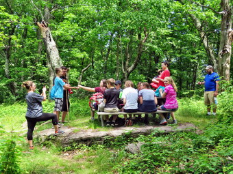
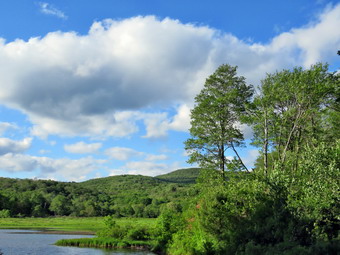
![]() On Saturday, June 15th I planned to start hiking early and perhaps do a 3500 foot peak or a flatter but longer route. On Thursday my son Karl called to see if we wanted to come watch their family run in the R4 5K Race in Rock Hill. Grandson Bryce, who is 8 year old wanted to run competitively with his dad. Luke and Lilly, the 6 year old twins, would run and walk with their mother Kathleen. Only 2 year old Brynn would not be in the race so her grandparents could watch her while the others ran. Cindy and I agreed so we met the family at the Rhulen building in Rock Hill just after 8:00 AM for the 9:00 AM race. Even Brynn had a number as she did not want to be left out! They all warmed up and then we made our way over to the start line. When the race started, I only saw Bryce as he began because the race is very popular and has many runners and walkers. I worked my way over to the finish line and then began to walk the course in reverse. I saw many runners that I knew and soon Bryce and Karl came in to view. I cheered them on and turned around to go back to the finish. I ran some in my heavy hiking boots and it felt pretty good despite the fact that it has been years since I ran! I found Cindy with Brynn along the way. Brynn wanted to find her mother and the twins so she and I turned around and followed the course in reverse. Brynn wanted to run and went for some distance before walking a little and the starting in again. We eventually found the rest of the family and Luke started running with his father as he wanted to keep a faster pace. We all ended up back at the finish line. Bryce printed out his results and found that his time of 26:27 was FIRST in the 10 and under age group! On the way back to the car, several Liberty students saw me and asked if they could join the cross country team. This was great news as I had though I would only have one or two runners but now have a good start on a team! I drive back to Livingston Manor to find Sheila ready to hike.
On Saturday, June 15th I planned to start hiking early and perhaps do a 3500 foot peak or a flatter but longer route. On Thursday my son Karl called to see if we wanted to come watch their family run in the R4 5K Race in Rock Hill. Grandson Bryce, who is 8 year old wanted to run competitively with his dad. Luke and Lilly, the 6 year old twins, would run and walk with their mother Kathleen. Only 2 year old Brynn would not be in the race so her grandparents could watch her while the others ran. Cindy and I agreed so we met the family at the Rhulen building in Rock Hill just after 8:00 AM for the 9:00 AM race. Even Brynn had a number as she did not want to be left out! They all warmed up and then we made our way over to the start line. When the race started, I only saw Bryce as he began because the race is very popular and has many runners and walkers. I worked my way over to the finish line and then began to walk the course in reverse. I saw many runners that I knew and soon Bryce and Karl came in to view. I cheered them on and turned around to go back to the finish. I ran some in my heavy hiking boots and it felt pretty good despite the fact that it has been years since I ran! I found Cindy with Brynn along the way. Brynn wanted to find her mother and the twins so she and I turned around and followed the course in reverse. Brynn wanted to run and went for some distance before walking a little and the starting in again. We eventually found the rest of the family and Luke started running with his father as he wanted to keep a faster pace. We all ended up back at the finish line. Bryce printed out his results and found that his time of 26:27 was FIRST in the 10 and under age group! On the way back to the car, several Liberty students saw me and asked if they could join the cross country team. This was great news as I had though I would only have one or two runners but now have a good start on a team! I drive back to Livingston Manor to find Sheila ready to hike.
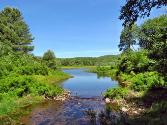
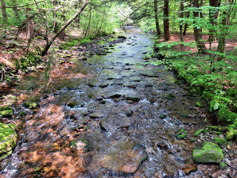
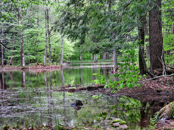
 Since it was already 11:00 AM when we got home, I knew I would have to stay closer to home than I had originally planned. I decided to go to Frock Pond and hike the loop that included both ponds. I though I might extend the hike if I felt like it but had no specific plans. By the time I started to get ready, the temperature was just reaching 70 degrees. I got dressed in a long-sleeved crew top with a short-sleeved baselayer. I put on a pair of RailRiders hiking pants which are expensive but last along time and have features like deep pockets and a generous cut which I really like. The pants have Velcro closures at the ankles which I hoped would discourage the ticks. I decided to wear my Vasque Talus hiking boots which have been my "go to" hiking boots. I also put on a wide-brimmed hat to combat the bright sun. I had a pair of Leki external lock poles which I have been using lately. The skies were blue with a few clouds and I knew the forecast did not call for any rain. Sheila was eager to get in the car so I got her in the backseat and put my gear in the car. We left Livingston Manor at 11:20 AM to head for Frick Pond. I drove out the DeBruce Road and turned left after six miles on Mongaup Pond Road. At the split in the road, I stayed to the left on Beech Mountain Road. When we arrived at the parking area, there were a few cars in the bigger lot. Two hikers were examining the kiosk map and I asked them if they wanted help. They declined so I got ready to get on the trail by setting my GPS. Sheila and I headed out the woods road that connects to the Quick Lake Trail at the register at 11:40 AM. The temperature was 73 degrees and there were clouds of insects swarming about. The woods road passed the register box to Frick Pond was wet from the rains which seem to fall several times a weak. At Gravestone Junction we stayed to the left on the red Quick Lake Trail crossing the stepping stones the Willowemoc Trail Crew had installed. We walked down to the pond and crossed the bridge over the outlet. The scene was much the same as always but I stopped to take a few pictures anyway. I picked up my pack and we walked on the trail along the west side of the pond. The trail continued to be wet and muddy in many spots but we were able to skirt most of them. At the trail junction with the Big Rock Trail, we headed left to stay on the Quick Lake Trail. We were keeping a pretty steady pace as we headed for Iron Wheel Junction. Sheila was running around following game trails and chasing a few chipmunks and squirrels. I removed a few branches from the trail as I walked along. The trail was wet and muddy. We passed through "spruce tunnel" to the small stream through the forest. The water was still high due to some blockages downstream so I walked a short distance upstream and crossed the stream. Sheila took a dip and came out of the water dashing madly up and down the trail. When we arrived at Iron Wheel Junction, we turned left to head toward Hodge Pond staying on the Quick Lake Trail.
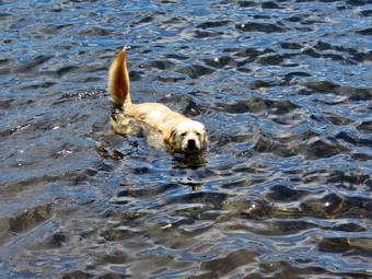
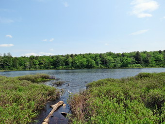
 We kept a quick pace up the hilly part of the trail. The trail was washed out in several places and I continued to remove small obstacles but at least it was dry compared to the lower sections. At one point we stopped and I put on some insect repellant as the mosquitoes were becoming an annoyance. We continued on the trail until it leveled off and descended slightly to Junkyard Junction at 3.1 miles. We turned right at this intersection and headed across the Flynn Trail toward Hodge Pond. The Flynn Trail was slightly damp in a few places and wet and muddy in others. The trip across this part of the Flynn Trail went quickly. Soon we were at the gate where the trail turns right and heads down toward Hodge Pond. We reached the area near the shore of the pond and turned left to follow the jeep trail around the back of the pond. The sky was still blue and there were a few more puffy white clouds so I decided to stop for a few moments at the head of the pond. The pond was very placid and there were almost no sounds. Sheila went for a swim and I took a few pictures of her and the pond. On the east side of the pond I turned left up the hill toward the ruins of the Beech Mountain Boy Scout Camp. The climb up this trail is steeper than the trail from the outlet of Hodge Pond but it is also shorter! When we got to the top of the hill, we turned right to head back toward the Flynn Trail. Once we were back at the Flynn Trail, we turned left on the Flynn Trail to head to the junction with the Big Rock Trail. We set a fast pace to the junction with the Big Rock Trail. I had thought about turning left at the junction and extending the hike by hiking over to Mongaup Pond. I decided I was a little too tired and it was a little too late so we continued straight ahead on the Flynn Trail. We had about 1.7 miles to go to get back to the car. This stretch can often seem long and boring but on this day I kept getting lost in my own thoughts which made the trip seem shorter. Everything was very green but not interesting enough to take pictures. As we neared the gate, we came to the huge spruce tree that lies across the trail. Cindy and I had cut an opening through it to allow hikers to pass. This was still in good shape and allowed us to pass easily. We followed the Flynn Trail to the gate and then turned left to continue on the trail to avoid the private property around the cabin. We followed the trail through the woods and back to the car. There were a few more cars parked in the lots. We arrived at 2:35 PM after hiking 6.3 miles in 2 hours and 55 minutes with 890 feet of elevation gain. We stopped for only 10 minutes and our overall and moving average speeds were both about 2.2 mph.
![]() On Sunday, June 9th I planned to do a hike with the youth group from Vine and Branch Church. After church, we had lunch and then headed over to Walnut Mountain for a short hike at 12:15 PM. I had changed into a long-sleeved Columbia crew top and a short-sleeved baselayer. I put on a pair of RailRiders hiking pants which are expensive but last a long time and have features like deep pockets and a generous cut which I really like. The pants have Velcro closures at the ankles. I decided to wear my Vasque Talus boots which are supportive and surprisingly roomy. I had a pair of Leki external lock poles which I have been using lately. We had to wait for the whole group to gather but were able to start the hike at 12:45 PM with about a dozen chidden and adults. We started up the main carriageway from the parking area. When we arrived at the trail junction with the Overlook Trail, we continued straight ahead and around the "back" of the mountain on the West Lake West Trail. Soon we were climbing up the hill to the first lookout. We stopped for a minute at the lookout but the leaves on the trees obscured much of the view. We could see some new housing being built in Swan Lake. We returned to the trail and started out descending and then ascending to a trail junction with the Overlook Trail. We turned left and followed the trail a short distance to the upper overlook. The picnic table which is usually found here was missing so we only took a few minutes to get a drink. I took a few pictures before we continued on the trails. We hiked up on the Sunset Trail to the Mountain House Trail toward the summit.
On Sunday, June 9th I planned to do a hike with the youth group from Vine and Branch Church. After church, we had lunch and then headed over to Walnut Mountain for a short hike at 12:15 PM. I had changed into a long-sleeved Columbia crew top and a short-sleeved baselayer. I put on a pair of RailRiders hiking pants which are expensive but last a long time and have features like deep pockets and a generous cut which I really like. The pants have Velcro closures at the ankles. I decided to wear my Vasque Talus boots which are supportive and surprisingly roomy. I had a pair of Leki external lock poles which I have been using lately. We had to wait for the whole group to gather but were able to start the hike at 12:45 PM with about a dozen chidden and adults. We started up the main carriageway from the parking area. When we arrived at the trail junction with the Overlook Trail, we continued straight ahead and around the "back" of the mountain on the West Lake West Trail. Soon we were climbing up the hill to the first lookout. We stopped for a minute at the lookout but the leaves on the trees obscured much of the view. We could see some new housing being built in Swan Lake. We returned to the trail and started out descending and then ascending to a trail junction with the Overlook Trail. We turned left and followed the trail a short distance to the upper overlook. The picnic table which is usually found here was missing so we only took a few minutes to get a drink. I took a few pictures before we continued on the trails. We hiked up on the Sunset Trail to the Mountain House Trail toward the summit.
 When the trail leveled off, we walked by some old foundations. I told the young people about the hotel that used to be at this location and the ski slopes. We walked left off the trail and followed the single-track bicycle trails up to the summit where we found a picnic table. We stopped to have a snack and get another drink. The young people read a Bible verse and the others tried to guess its origin. We took some pictures and then packed up to leave. We walked around the summit on the single-track trails crossing over the bridges the mountain bike club built. We walked down the other side to a path and then out to the Mountain House Trail. When this trail intersected the Sunset trail, we turned right and walked down to the Overlook Trail. A right turn placed us on the Overlook Trail which we walked back to the lower lookout. This time we turned left and followed the East Trail down the hill. The trail passed by the Frisbee golf course and ended at the playground. Parents were already present to pick up their children. It was 2:25 PM and we had hiked 2.8 miles in 1 hour and 40 minutes. The total elevation gain was 490 feet. The hike went so well that others will be scheduled in the future.
![]()
![]()
![]()
![]()
![]() On Saturday, June 8th I wanted to do a hike farther away from home with more distance and difficulty. I planned on going to North South Lake and hiking a good part of the Escarpment Trail. Cindy agreed to go with me and we began to get ready just before 9:00 AM when the temperature was already in the 60's! The highs for the days were forecast to reach 80 degrees in some places. As we got our gear together, Sheila seemed to be in complete agreement with my decision as she followed me around as I was dressing. I put on a long-sleeved Columbia crew top and a short-sleeved baselayer. I put on a pair of RailRiders hiking pants which are expensive but last a long time and have features like deep pockets and a generous cut which I really like. The pants have Velcro closures at the ankles. I decided to wear my Vasque Talus boots which are supportive and surprisingly roomy. I put a very light windbreaker in my pack in case I needed an added layer. I added a pair of OR Bugout gaiters to combat the mud and the ticks. We put our gear in the car and Sheila in the backseat and drove out DeBruce Road just after 9:00 AM. I drove to the end of the road and turned left on Route 47. We passed Frost Valley YMCA Camp and came to the parking area for Biscuit Brook. The lot was almost full. Further along, the parking area for Slide Mountain was also almost full. At the Panther-Giant Ledge area, the lot was full and cars were already parked on the road. Cindy and I decided that there would probably be too many people at North South Lake and many other places in that area. We considered Winter Clove but decided it was too far away. We settled on hiking to Bellayre from Lost Clove. I continued on Route 47 to Lost Clove Road where I turned left. I drove to the end and pulled into the parking lot which was empty! I set my GPS unit and we started out on the trail at 9:40 AM. We started right in as there is no trail register on this trail. Sheila was out like a shot well ahead of us as we had not hiked for two days. The first mile is an easement on private property. I remembered that the first part of the hike was steep but had forgotten how steep. For a good part of the first mile the trail simply goes UP with only short level parts to recover. To make things more difficult the trail has many loose stones. The temperature was in the low 80's with some humidity to make it more uncomfortable.
On Saturday, June 8th I wanted to do a hike farther away from home with more distance and difficulty. I planned on going to North South Lake and hiking a good part of the Escarpment Trail. Cindy agreed to go with me and we began to get ready just before 9:00 AM when the temperature was already in the 60's! The highs for the days were forecast to reach 80 degrees in some places. As we got our gear together, Sheila seemed to be in complete agreement with my decision as she followed me around as I was dressing. I put on a long-sleeved Columbia crew top and a short-sleeved baselayer. I put on a pair of RailRiders hiking pants which are expensive but last a long time and have features like deep pockets and a generous cut which I really like. The pants have Velcro closures at the ankles. I decided to wear my Vasque Talus boots which are supportive and surprisingly roomy. I put a very light windbreaker in my pack in case I needed an added layer. I added a pair of OR Bugout gaiters to combat the mud and the ticks. We put our gear in the car and Sheila in the backseat and drove out DeBruce Road just after 9:00 AM. I drove to the end of the road and turned left on Route 47. We passed Frost Valley YMCA Camp and came to the parking area for Biscuit Brook. The lot was almost full. Further along, the parking area for Slide Mountain was also almost full. At the Panther-Giant Ledge area, the lot was full and cars were already parked on the road. Cindy and I decided that there would probably be too many people at North South Lake and many other places in that area. We considered Winter Clove but decided it was too far away. We settled on hiking to Bellayre from Lost Clove. I continued on Route 47 to Lost Clove Road where I turned left. I drove to the end and pulled into the parking lot which was empty! I set my GPS unit and we started out on the trail at 9:40 AM. We started right in as there is no trail register on this trail. Sheila was out like a shot well ahead of us as we had not hiked for two days. The first mile is an easement on private property. I remembered that the first part of the hike was steep but had forgotten how steep. For a good part of the first mile the trail simply goes UP with only short level parts to recover. To make things more difficult the trail has many loose stones. The temperature was in the low 80's with some humidity to make it more uncomfortable.
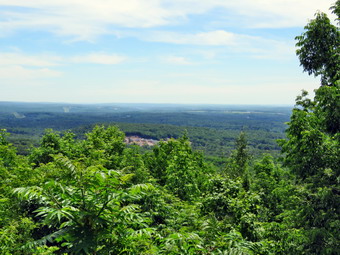
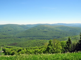
 After 1.25 mile the trail meets the Pine Hill West Branch Trail. We turned left to head toward the Belleayre Ski Area. The trail continued to ascend although a little more gradually. At 1.5 we stopped at a lean-to on the right side of the trail. The lean-to is old and in poor shape but it gave us a chance to sit and get out of the sun. We had a drink and a bar and both of us felt better when we started back on the trail. We continued to ascend to 2 miles where the trail opened into a small clearing and flatten out. I walked to the left side of the trail and found the USGS seal. We continued to walk along the wide woods roads on the ridge as they rolled up and down. We passed the first ski run called Cathedral Glen and followed the trail until it brought us to the main ski area. This area has the ski lodge, the main lifts and the ski patrol headquarters. I pointed out to Cindy that the door to the lodge appeared to be open which seemed very strange. I walked over to the top of one of the ski runs and took some pictures. There was some haze in the valley and on the mountains but I thought I got some good shots. I worked my way along the ski area taking more pictures including some of the lifts and buildings. I intended to walk along the entire ridge to the Deer Run area but Cindy decided to stay behind. Shiela and I headed out the road toward the end of the ridge. We noticed a couple coming toward us and I put Sheila on her leash. These were the first people we had seen all day! As we walked I could see that there was construction ahead. I was surprised to see a gondola lift running with none of the cars occupied. We walked passed it to the point where the ridge began to drop. We turned around and walked back to the area of the gondola where I took some pictures and spoke to the operator. He said the gondola was about three years old and a round trip ride was $20 per person. As we turned to walk back to the ski lodge, I stopped once again to take some pictures along the ridge.
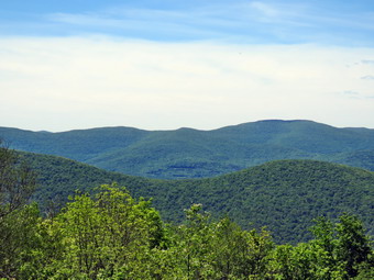 Sheila and I walked back and met Cindy. I took a few more pictures of the valley and mountains. We then walked over to the ski lodge which was indeed open. I had made a mistake and not brought enough water. I went inside and asked the attendant if she would fill a water bottle. She readily agreed so I gave Sheila the last of the water in the bottle and took it inside to be filled. From the porch on the lodge I took some pictures of Balsam and Eagle Mountains. At 12:25 PM we picked up to start back to the car. The walk along the ridge went quickly and we were soon walking the woods road back to the clearing with the USGS seal. We entered the woods and started down the trail passing the lean-to. Just before the trail junction we met another couple coming up the trail. We exchanged brief greetings and continued in our opposite directions. We had been descending and at 5.8 miles turned right to begin the final descent. I was getting more and more tired and my feet were beginning to bother me as my toes hit the end of my boots. Cindy was behind me and I could see she was not doing well. After descending some, we stopped and I gave her a drink and a bar and had some myself. This seemed to help some and we continued to descend. We stopped one more time when I knew we were within a few minutes of the car. We decided I would go ahead with both of our pack, put them in the car and then return for Cindy. Sheila and I hurried down to the car making it there in only a few minutes. I put the packs and Sheila in the car and then started back up the trail to help Cindy down. She had been able to make it down most of the trail and I helped her the rest of the way. I gave her some water and we stopped at a gas station where I got some juice. We had hiked 7.1 miles in 4.5 hours with and elevation gain of 2295 feet.
![]()
![]()
![]()
![]() On Thursday, June 5th I came home immediately after school as we did not have track practice. My return to full-time teaching combined with coaching track has really cut into my hiking time! When I got home and asked Sheila if she wanted to go hiking, she began barking, running around frantically and spinning in place. Sheila misses the hiking as much as I do. Since I just wanted some exercise, I decided to go across the street to Round Top. The temperature was in the high 70's so I knew I could dress for warm weather. I put on my long-sleeved Mammut crew top. I knew this might be a little too warm but felt I don't mind being warm. I put on a pair of RailRiders hiking pants which are expensive but last a long time and have features like deep pockets and a generous cut which I really like. The pants have Velcro closures at the ankles. I decided to wear my Keen Targhee III boots which are supportive and surprisingly roomy. I grabbed a pair of Leki poles with external locks that I have been using lately. At 3:55 PM we walked out the door to start the hike. I grabbed Sheila's leash from the car and we walked up the driveway. I decided we would try to do at least two figure 8's which might be enough given the situation. I aimed to hike for about an hour. Sheila was happy to get out as we headed down the driveway and across the street. We crossed the street and walked to the parking area by the Presbyterian Church. We walked to the back of the church and began the ascent of the steepest hill behind the church. The hill is short but gets the circulation pumping and is the steepest and longest climb on the "trail." Sheila helped me along by pulling me up the hill.
On Thursday, June 5th I came home immediately after school as we did not have track practice. My return to full-time teaching combined with coaching track has really cut into my hiking time! When I got home and asked Sheila if she wanted to go hiking, she began barking, running around frantically and spinning in place. Sheila misses the hiking as much as I do. Since I just wanted some exercise, I decided to go across the street to Round Top. The temperature was in the high 70's so I knew I could dress for warm weather. I put on my long-sleeved Mammut crew top. I knew this might be a little too warm but felt I don't mind being warm. I put on a pair of RailRiders hiking pants which are expensive but last a long time and have features like deep pockets and a generous cut which I really like. The pants have Velcro closures at the ankles. I decided to wear my Keen Targhee III boots which are supportive and surprisingly roomy. I grabbed a pair of Leki poles with external locks that I have been using lately. At 3:55 PM we walked out the door to start the hike. I grabbed Sheila's leash from the car and we walked up the driveway. I decided we would try to do at least two figure 8's which might be enough given the situation. I aimed to hike for about an hour. Sheila was happy to get out as we headed down the driveway and across the street. We crossed the street and walked to the parking area by the Presbyterian Church. We walked to the back of the church and began the ascent of the steepest hill behind the church. The hill is short but gets the circulation pumping and is the steepest and longest climb on the "trail." Sheila helped me along by pulling me up the hill.
When we got to the top of the hill, I looked around and saw some clouds gathering that might bring rain. We started on the trail by turning left at the trailhead. I thought I heard some voices coming from the trail but couldn't be sure. I let Sheila off her leash, and she began to explore the trail with her nose. As we followed the trail, I again heard the voices and saw a group coming toward us. I pit Sheila back on her leash as they approached. There were several mothers with children and one had a dog on a leash. The dog was a four month old Saint Bernard puppy which was as big as Shiela. We passed each other in opposite directions with the two dogs showing great interest in each other. The trail bed is becoming worn it which means that a few people are using the trail. I am always happy to see that someone else uses the trails. At the first trail junction, I followed Sheila as she turned right on the woods road which is the shallower approach to the trail system. There was a branch hanging down into the trail and I made a note to bring my loppers on the next trip. I continued to follow the yellow trail to the first junction where we turned left and followed it to the next trail junction. Along the way I removed a small tree trunk that had fallen across the trail. At the second junction with the blue trail, we turned right and started up the steep blue trail that leads over the summit of Round Top. We walked across the flat summit of Round Top and started down the other side. Soon we were back at the yellow trail. We turned right and walked the yellow trail to the next trail junction. Here we turned left and followed the yellow trail downhill to the lookout. There wasn't much to see at the lookout so we continued on the trail. We followed the yellow trail as it turned left and descended the hill to the first trail junction. The walk had gone quickly, so we turned around and started back up the hill back to the lookout. Sometimes Sheila resists another loop but this time she was in the lead. We followed the yellow trail uphill toward the lookout and turned right to continue up to the next trail junction with the blue trail. At the trial junction, we turned right to stay on the yellow trail. At the next junction we turned left to climb the shallower side of the summit ascent. We again walked across the flat summit and descended the steeper trail. At the trail junction, we turned left and followed the yellow trail along the base of Round Top. At the next junction we turned right this time to follow the trail down to the woods road that leads out to the first trial junction. That was enough for me given the time. We turned left and walked out to the trailhead. Sheila was well-behaved and stayed with me most of the time. I put her on her leash and we walked down the cemetery hill. We walked out through the church parking lot to the road and to our driveway. It was 5:00 PM and we had hiked over 2 miles in an hour.
![]()
![]()
![]()
![]()
![]() On Monday, June 3rd, I planned to go for a hike after coming home from school. This was the FIRST day in months that I did not have track practice after school as the season had ended. I knew I couldn't go very far from home and decided to go to Frick Pond. My plan was to hike to Hodge Pond on the Flynn Trail and then return to the junction with the Big Rock Trail. From here I would hike to the end of the Big Rock Trail around the back of Frick Pond and then on the Quick Lake Trail back to the parking area. I arrived home a little later than expected but the weather was beautiful and I decided to follow my plan. As I got my gear together just before 4:00 PM, Sheila seemed to be in complete agreement with my decision as she followed me around as I was dressing. The temperature was in the 50's and it felt at least that warm. I put on a long-sleeved Columbia crew top and a short-sleeved baselayer. I put on a pair of RailRiders hiking pants which are expensive but last a long time and have features like deep pockets and a generous cut which I really like. The pants have Velcro closures at the ankles. I decided to wear my Vasque Talus boots which are supportive and surprisingly roomy. I put a very light windbreaker in my pack in case I needed an added layer. I added a pair of OR Bugout gaiters to combat the mud and the ticks. I put my gear in the car and Sheila in the backseat and drove out DeBruce Road just before 4:00 PM. After 6 miles I turned left on Mongaup Road. Where the road splits, I stayed left on Beech Mountain Road and parked in the smaller lot at 4:10 PM. There was one other car in the lot. I promptly set my GPS unit to get ready for the hike. We crossed the road and started out on the Flynn Trail at 4:15 Pm which was a little later than I wanted. Despite teaching for a full day, I felt very energetic and set a fast pace on the trail through the woods. At the end of the trail we turned right on what was once Beech Mountain Road and started the long but gentle ascent to the junction with the Big Rock Trail. There was a slight breeze blowing which made me feel a little cool at first but this feeling disappeared as I hiked. The sky was blue with white clouds and all the trees were very green. The trail was only damp in places which made keeping a fast pace easier. I was trying to make the junction in 30 minutes but it took us almost 40 minutes to hike the 1.7 miles to the junction.
On Monday, June 3rd, I planned to go for a hike after coming home from school. This was the FIRST day in months that I did not have track practice after school as the season had ended. I knew I couldn't go very far from home and decided to go to Frick Pond. My plan was to hike to Hodge Pond on the Flynn Trail and then return to the junction with the Big Rock Trail. From here I would hike to the end of the Big Rock Trail around the back of Frick Pond and then on the Quick Lake Trail back to the parking area. I arrived home a little later than expected but the weather was beautiful and I decided to follow my plan. As I got my gear together just before 4:00 PM, Sheila seemed to be in complete agreement with my decision as she followed me around as I was dressing. The temperature was in the 50's and it felt at least that warm. I put on a long-sleeved Columbia crew top and a short-sleeved baselayer. I put on a pair of RailRiders hiking pants which are expensive but last a long time and have features like deep pockets and a generous cut which I really like. The pants have Velcro closures at the ankles. I decided to wear my Vasque Talus boots which are supportive and surprisingly roomy. I put a very light windbreaker in my pack in case I needed an added layer. I added a pair of OR Bugout gaiters to combat the mud and the ticks. I put my gear in the car and Sheila in the backseat and drove out DeBruce Road just before 4:00 PM. After 6 miles I turned left on Mongaup Road. Where the road splits, I stayed left on Beech Mountain Road and parked in the smaller lot at 4:10 PM. There was one other car in the lot. I promptly set my GPS unit to get ready for the hike. We crossed the road and started out on the Flynn Trail at 4:15 Pm which was a little later than I wanted. Despite teaching for a full day, I felt very energetic and set a fast pace on the trail through the woods. At the end of the trail we turned right on what was once Beech Mountain Road and started the long but gentle ascent to the junction with the Big Rock Trail. There was a slight breeze blowing which made me feel a little cool at first but this feeling disappeared as I hiked. The sky was blue with white clouds and all the trees were very green. The trail was only damp in places which made keeping a fast pace easier. I was trying to make the junction in 30 minutes but it took us almost 40 minutes to hike the 1.7 miles to the junction.
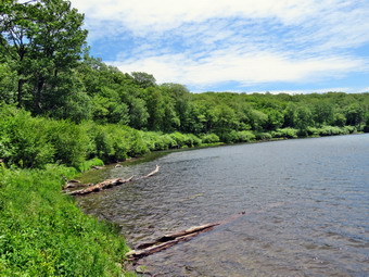
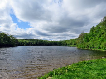
 We did not stop and continued straight ahead toward Hodge Pond. At the split in the trail, we stayed to the left and followed the Flynn Trail down to the shores of the pond. I chose to do this since the walk back up this hill always seems long even though the slope is gradual. Clouds had begun to gather over the pond a the breeze was blowing harder. I set my pack down and took out my camera to take some pictures of the pond. I was angularly interested in the clouds over the pond. Sheila jumped right into the water and walked around getting a drink. After taking some pictures, I packed up and considered my options. It was getting late so I decided not to hike around the pond since the only reason to do that was to add distance. I decided to follow the woods road up the hill on the east side of Hodge Pond. At the top of the short but steep climb, we turned right and walked the woods road back to the Flynn Trail. At the Flynn Trail. We turned left to walk back to the junction with the Big Rock Trail. At the junction, we turned right and started down the Big Rock Trail toward Times Square. The downhill walk went quickly and I must have been absorbed in my thoughts because I did not even notice the three distinct sections of the descent. When we arrived at Times Square, we continued straight across on the Big Rock Trail. I was surprised that the area was much drier than when we had worked on the drainage. The trail around the back of the pond was damp and slightly muddy in spots. As we entered the spruce trees, I stopped to take a few pictures before continuing on the trail. I found a couple of other spots to take some shots including a few of the wetlands at the north end of the pond and the wooden walkways. At the end of the Big Rock Trail, we turned left on the Quick Lake Trail to continue on to the bridge over the outlet stream from Frick Pond. At the bridge, we stopped and I took off my pack to take a few more pictures. I have many pictures from this spot but can never resist taking a few shots. I find this one of the most beautiful places in the Catskills. When I was finished taking pictures, I packed up and we continued on the Quick Lake Trail through Gravestone Junction. The woods road back to the car showed the results of the work we had done on the drainage. It was certainly drier than I expected and it was evident the ditches we had created were working to direct water off the rail. We arrived back at the car at 6:15 PM after hiking 5.5 miles in 2 hours and 5 minutes. The elevation gain was 855 feet.
![]()
![]()
![]()
![]()
![]() On Saturday, June 1st, I was ready to get out for hike on National Trails Day. Brad was back for weekend so I thought we might go to North South Lake but remembered that the weekends there are very busy. I decided on a visit to Dry Brook Ridge which has a nice climb and a good view of the Pepacton Reservoir. Bard and I collected the recyclables and garbage and went to the landfill. When we returned home the skies had clouded over and some rain was falling. Brad was going to have to stay home with a sick child so I changed my plans to stay closer to home. I decided I would go to Long Pond and hike a figure 8 loop of a little over 7 miles. This is an area that I visit often along with Frick Pond and Trout Pond. I hoped there wouldn't be too many people and that the trails would be in good shape. I started to get ready just before noon and Sheila made it clear she approved of my decision. I put on a long-sleeved Columbia crew top over an Underarmor short-sleeved baselayer. I put on a pair of RailRiders hiking pants which are expensive but last a long time and have features like deep pockets and a generous cut which I really like. The pants have Velcro closures at the ankles. I decided to wear my Vasque Talus boots which are supportive and surprisingly roomy. The temperature was already in the 70's and the sun had returned so I knew I would not need a jacket although I did put a rain jacket in my pack. I added a pair of OR Bugout gaiters to combat the mud and ticks. I put our gear in the trunk and an overjoyed Sheila in the back seat as I headed out the DeBruce Road. As I drove, several other plans came to mind but I decided to stick to the original one. I passed Mongaup Pond Road and continued to Willowemoc where I turned left on Flugertown Road. After a short distance, I pulled into the parking lot in the right where I was surprised to find no other cars. I set my GPS and put Sheila on her leash as we began our walk up Flugertown Road with the temperature in the low 70's. There was a slight breeze and I did not notice any insects as we hiked northward on the paved road.
On Saturday, June 1st, I was ready to get out for hike on National Trails Day. Brad was back for weekend so I thought we might go to North South Lake but remembered that the weekends there are very busy. I decided on a visit to Dry Brook Ridge which has a nice climb and a good view of the Pepacton Reservoir. Bard and I collected the recyclables and garbage and went to the landfill. When we returned home the skies had clouded over and some rain was falling. Brad was going to have to stay home with a sick child so I changed my plans to stay closer to home. I decided I would go to Long Pond and hike a figure 8 loop of a little over 7 miles. This is an area that I visit often along with Frick Pond and Trout Pond. I hoped there wouldn't be too many people and that the trails would be in good shape. I started to get ready just before noon and Sheila made it clear she approved of my decision. I put on a long-sleeved Columbia crew top over an Underarmor short-sleeved baselayer. I put on a pair of RailRiders hiking pants which are expensive but last a long time and have features like deep pockets and a generous cut which I really like. The pants have Velcro closures at the ankles. I decided to wear my Vasque Talus boots which are supportive and surprisingly roomy. The temperature was already in the 70's and the sun had returned so I knew I would not need a jacket although I did put a rain jacket in my pack. I added a pair of OR Bugout gaiters to combat the mud and ticks. I put our gear in the trunk and an overjoyed Sheila in the back seat as I headed out the DeBruce Road. As I drove, several other plans came to mind but I decided to stick to the original one. I passed Mongaup Pond Road and continued to Willowemoc where I turned left on Flugertown Road. After a short distance, I pulled into the parking lot in the right where I was surprised to find no other cars. I set my GPS and put Sheila on her leash as we began our walk up Flugertown Road with the temperature in the low 70's. There was a slight breeze and I did not notice any insects as we hiked northward on the paved road.
 It was a beautiful day and all the trees were green as we hiked along the flat road. The streams that we crossed were high but not overflowing. After about half a mile we came to the spot where the pavement ends and the road turns to gravel. We walked a little farther before I released Sheila from the leash to continue the hike. We kept a quick pace along the road and the walk was pleasant with the creek flowing beside the road. In another mile, we turned right off the road onto the snowmobile trail and walked to the first bridge. I stopped and took a few pictures and then continued on over the next bridge. From that point the trail continued up a short but steep hill heading south toward a trail junction. Once the trail flattened at the top of the hill, there are several large ponds and mudpits that stretched across the trail. Other hikers had widened the trail and we were able to make our way around the worst spots. At 2.2 miles we came to the trail junction and turned left on the snowmobile trail heading east, south and then northeast. In less than half a mile, a spur trail headed off to the right. This trail goes to a lean-to just off the shore of Long Pond. We stayed on the main trail and continued to encounter muddy and wet areas which made for less than ideal hiking. At 3.3 miles, we passed through the gate across the trail and turned left on the woods road. The road had many ruts and was very muddy. As we walked, both Sheila and I heard a engine coming toward us. A pickup truck appeared and drove passed without stopping or the driver even acknowledging we were present. We continued along the road until we came to a stream flowing from a beaver pond at 4.2 miles. We stopped for a few minutes so that I could take a few pictures. Ahead of us was private property belonging to the Peters Hunting Club. It seems there may be a right-of-way across the land but the bridge across Willowemoc Creek is private. I had asked and been given permission to walk across the land and the bridge so we continued ahead. We crossed the bridge and followed the road as it made a sharp left turn. We stopped on the road just before it entered the woods and I took some pictures of the valley.
 We continued along the road avoiding the wet spots and heading southwest for about .9 miles to the junction with the snowmobile trail. We turned left off the road and onto the same snowmobile trail we had traveled earlier in the hike. We again crossed the two bridges and walked uphill. The walk to the trail junction seemed to go quickly and we were soon back at the trail junction. This time we turned right and started back toward the parking area along the main trail. After .2 miles, a short spur trail branched off to the left leading down to the shores of Long Pond. At the end of the trail, I dropped my pack and took out my camera. I took some pictures of the pond and the surrounding area. I could hear several red-wing blackbirds and see a few but none were close enough to take pictures. I walked back to my pack, stowed the camera and walked back up to the main trail. We turned left and continued a little uphill trying to avoid the numerous muddy and wet areas. At one point we saw a hiker coming toward us so I put Sheila on her leash. We stopped for a minute to say "Hello" and then continued in opposite directions. The rest of the walk was a little over a half mile with over a 350 foot elevation drop. We arrived back at the car at 3:25 PM after hiking 7.2 miles in 3 hours and 10 minutes with a 760 foot elevation gain.
![]()
![]()
![]()
![]()
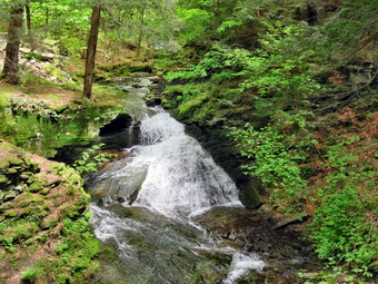
![]() On Saturday, May 25th, I was ready to get out for a second day of hiking in a row, something I had not done for a very long time. My son-in-law Brad was visiting and wanted to come along. I decided we would go to Trout Pond since I knew the 3500 foot peaks would be busy because of the long weekend and the beautiful weather. When I got up, the temperature was already in the high 50's, and the sun was shining with bright blue skies. This was a welcome change from the previous days which were cloudy and rainy. We ate breakfast and took care of Moe things around the house before preparing to hike. We started to get ready just before 11:00 AM and Sheila made it clear she approved of our decision. I put on a long-sleeved Columbia crew top as I like the protection when working. I put on a pair of RailRiders hiking pants which are expensive but last a long time and have features like deep pockets and a generous cut which I really like. The pants have Velcro closures at the ankles. I decided to wear my Vasque Talus boots which are supportive and surprisingly roomy. I decided to put on a very light windbreaker and added a pair of OR Bugout gaiters to combat the mud. We put our gear in the trunk and an overjoyed Sheila in the back seat as we headed to Roscoe on State Route 17 at 11:20 AM. I got on Route 206 and followed it across the Delaware County line to Morton Hill Road. After a left turn on Morton Hill Road, I drove to the intersection with Russell Brook Road. The open area at the top intersection was already parked full with one car just pulling in. I parked legally along the side of the road. When I got out of the car, I informed the young couple that they were parking on private property and that the land owner, understandably, objected to his. They thanked me and pulled out to park somewhere else. The number of cars parked seemed to indicate that there would be quite a few people at Trout Pond. I set my GPS and put Sheila on her leash as we began our walk down Russell Brook Road at 11:40 AM. There were several cars parked at the first illegal campsite on the right side of the road. Several tents were set up and a portable generator was running. A perfect getaway from the hustle and bustle of the world! We continued to walk down the road and found the next decimated campsite on the left filled and some cars blocking the trail on the right. We walked down the path to the area that overlooks the upper waterfalls. Even though I have many pictures from this spot, I often stop to take more as I find it beautiful. The water was high but not as high as I expected. I took quite a few pictures with different settings. We returned to the road and continued down to the lower lot which was almost filled with cars. The road had been very dry and I wondered if this would be true for the rest of the hike. As we crossed the bridge and started on the trail, we passed the Japanese knotweed which was just beginning to grow. I knew that I would be spending some time cutting this back in the bear future. We turned right onto the path to the falls, and I worked our way down the bank to the streambed. The path has become more and more delineated and easier to negotiate. The falls were flowing freely but did not have as much volume as I have seen. I got out my camera and took quite a few shots of the falls and the stream. Sheila posed in front of the falls and I took a few shots. We walked up the bank and turned left to walk back out to the main trail. We turned right and walked to the trail register. I noticed that the campsite to the right was also filled.
On Saturday, May 25th, I was ready to get out for a second day of hiking in a row, something I had not done for a very long time. My son-in-law Brad was visiting and wanted to come along. I decided we would go to Trout Pond since I knew the 3500 foot peaks would be busy because of the long weekend and the beautiful weather. When I got up, the temperature was already in the high 50's, and the sun was shining with bright blue skies. This was a welcome change from the previous days which were cloudy and rainy. We ate breakfast and took care of Moe things around the house before preparing to hike. We started to get ready just before 11:00 AM and Sheila made it clear she approved of our decision. I put on a long-sleeved Columbia crew top as I like the protection when working. I put on a pair of RailRiders hiking pants which are expensive but last a long time and have features like deep pockets and a generous cut which I really like. The pants have Velcro closures at the ankles. I decided to wear my Vasque Talus boots which are supportive and surprisingly roomy. I decided to put on a very light windbreaker and added a pair of OR Bugout gaiters to combat the mud. We put our gear in the trunk and an overjoyed Sheila in the back seat as we headed to Roscoe on State Route 17 at 11:20 AM. I got on Route 206 and followed it across the Delaware County line to Morton Hill Road. After a left turn on Morton Hill Road, I drove to the intersection with Russell Brook Road. The open area at the top intersection was already parked full with one car just pulling in. I parked legally along the side of the road. When I got out of the car, I informed the young couple that they were parking on private property and that the land owner, understandably, objected to his. They thanked me and pulled out to park somewhere else. The number of cars parked seemed to indicate that there would be quite a few people at Trout Pond. I set my GPS and put Sheila on her leash as we began our walk down Russell Brook Road at 11:40 AM. There were several cars parked at the first illegal campsite on the right side of the road. Several tents were set up and a portable generator was running. A perfect getaway from the hustle and bustle of the world! We continued to walk down the road and found the next decimated campsite on the left filled and some cars blocking the trail on the right. We walked down the path to the area that overlooks the upper waterfalls. Even though I have many pictures from this spot, I often stop to take more as I find it beautiful. The water was high but not as high as I expected. I took quite a few pictures with different settings. We returned to the road and continued down to the lower lot which was almost filled with cars. The road had been very dry and I wondered if this would be true for the rest of the hike. As we crossed the bridge and started on the trail, we passed the Japanese knotweed which was just beginning to grow. I knew that I would be spending some time cutting this back in the bear future. We turned right onto the path to the falls, and I worked our way down the bank to the streambed. The path has become more and more delineated and easier to negotiate. The falls were flowing freely but did not have as much volume as I have seen. I got out my camera and took quite a few shots of the falls and the stream. Sheila posed in front of the falls and I took a few shots. We walked up the bank and turned left to walk back out to the main trail. We turned right and walked to the trail register. I noticed that the campsite to the right was also filled.
 At the trail junction just after the register, we turned to the left to climb the steeper hill toward Mud Pond. The campsite on the right side of the trail just after the bridge had only one small tent. The trail continued to be very dry although there was evidence there had been a lot of water flowing down the trail. There were some occasional branches on the trail which we picked up and moved off the trail. The skies remained bright and blue with few clouds. On the ascent, we took a few breaks but it went quickly, and I was glad to see there were no major blowdowns on this part of the trail. We reached the top of the hill and walked down the wide woods road to the next trail junction at 1.6 miles. I continued to be surprised that the trail was so dry. We made a right to follow the trail up to the shoulder of Cherry Ridge. These trail sections are usually underwater were barely damp. We continued to remove branches, but there were no major blockages. After passing through an area with many small diameter trees, we started a short descent. After that, there was an ascent which continued for the next 1.2 miles until at 2.7 miles into the hike when we were at the highest point and ready to start the descent to Trout Pond. At some point, I heard Sheila yelp and called her back to the trail. She came pretty quickly but she was limping! I was upset but it wasn't very long before she was running normally. I had found the climb tiring but fulfilling and knew the descent would be easier. As we descended toward Trout Pond, the skies began to cloud over and some light rain began to fall. We met a couple coming toward us who were headed toward Mud Pond to camp. The last part of the trail down to Trout Pond is usually a stream but on this day it was dry. As we approached the bridge at the inlet end of the pond, the rain began to increase and I scrapped the idea of stopping to take pictures. We walked over the bridge and suddenly the trail began to be extremely muddy with deep tire tracks. This was a complete contrast to what we had experienced so far. To get around the muddiest area, we detoured into the large camping area just as a group of hikers was approaching from the other directions. They seemed distressed that we might claim the campsite until I assured them we were not. We continued on the main trail toward the outlet of the pond with some difficulty since there were areas of water that spanned the width of the trail. There were also deep ruts wide enough to indicate a pickup or some other kind of truck. We met a few more hikers and groups of hikers headed toward the inlet end of the pond. I had intended to stop at the lower end of the pond, but the rain was falling so we stopped only long enough to deploy our pack covers. The hike from the outlet to the trail junction is all downhill, and we were able to make pretty good time despite the rain. On the way down the trail we met several groups coming toward us. One group of 5 or 6 people was hiking with five dogs. I immediately put Sheila on her leash but NONE of the dogs in the other group was leashed. This is ANOTHER example of inconsiderate dog owners whose only concern is their own convenience. We continued passed the trail register and crossed the bridge over Russell Brook. We walked up the hill to the parking area and then on up the road to the car. We arrived back at the car at 2:30 PM having covered 5.7 miles and 1120 vertical feet in 2 hours and 50 minutes.
![]()
![]()
![]()
![]()
![]() On Friday, May 24th I decided to get out and hike with my grandson Bryce. Bryce is 8 years old and has already hiked many of the 3500 foot peaks with me and many other trails. I was trying to decide which mountain he should climb and had settled on something on the evil's Path or in the Blackhead Range. Bryce was supposed to arrive at our house between 8:30 AM and 9:00 AM. Around 8:15 AM, the ambulance pager sounded and I knew that would change my plans! When I returned from the call at 11:00 AM, Bryce was there. We did a few things around the house and then began to get ready to hike. We decided to go to Frick Pond and inspect the work that had been done the previous Sunday. As I got my gear together, Sheila seemed to be in complete agreement with my decision as she followed me around as I was dressing. The temperature was in the 60's and it felt at least that warm. I put on a long-sleeved Columbia crew top as I like the protection when working. I put on a pair of RailRiders hiking pants which are expensive but last a long time and have features like deep pockets and a generous cut which I really like. The pants have Velcro closures at the ankles. I decided to wear my Vasque Talus boots which are supportive and surprisingly roomy. I decided to put on a very light windbreaker and added a pair of OR Bugout gaiters to combat the mud. I had not completely planned a route but thought we would hike out the Quick Lake Trail to Iron Wheel Junction and the make a decision which direction we would go. Sheila was happy to be going anywhere and crouched in the back seat with her head on the console. Bryce sat in the back with Sheila as I drove out DeBruce Road just after noon. After 6 miles I turned left on Mongaup Road. Where the road splits, I stayed left on Beech Mountain Road and parked in the smaller lot at 12:25 PM. There were no other cars in the lot which surprised me since I expected some people might have extended the Memorial Day weekend. I set my GPS unit to get ready for the hike. We started out the woods road that becomes the Quick Lake Trail at the register box. Starting at the register the trail was wet and muddy but it was clear that the drainage work we had done was helping to direct some of the water off the trail. The woods road out to Frick Pond continued to be wet but we were able to avoid the worst spots. We stayed left at Gravestone Junction to stay on the Quick Lake Trail. When we arrived at the bridge across the outlet, I decided to stop and take pictures even though I have hundreds from this location. The water level in the pond was moderately high and the outlet stream was flowing freely. I took some shots of Bryce and Sheila on the bridge and a few of the pond and Flynn's Point.
On Friday, May 24th I decided to get out and hike with my grandson Bryce. Bryce is 8 years old and has already hiked many of the 3500 foot peaks with me and many other trails. I was trying to decide which mountain he should climb and had settled on something on the evil's Path or in the Blackhead Range. Bryce was supposed to arrive at our house between 8:30 AM and 9:00 AM. Around 8:15 AM, the ambulance pager sounded and I knew that would change my plans! When I returned from the call at 11:00 AM, Bryce was there. We did a few things around the house and then began to get ready to hike. We decided to go to Frick Pond and inspect the work that had been done the previous Sunday. As I got my gear together, Sheila seemed to be in complete agreement with my decision as she followed me around as I was dressing. The temperature was in the 60's and it felt at least that warm. I put on a long-sleeved Columbia crew top as I like the protection when working. I put on a pair of RailRiders hiking pants which are expensive but last a long time and have features like deep pockets and a generous cut which I really like. The pants have Velcro closures at the ankles. I decided to wear my Vasque Talus boots which are supportive and surprisingly roomy. I decided to put on a very light windbreaker and added a pair of OR Bugout gaiters to combat the mud. I had not completely planned a route but thought we would hike out the Quick Lake Trail to Iron Wheel Junction and the make a decision which direction we would go. Sheila was happy to be going anywhere and crouched in the back seat with her head on the console. Bryce sat in the back with Sheila as I drove out DeBruce Road just after noon. After 6 miles I turned left on Mongaup Road. Where the road splits, I stayed left on Beech Mountain Road and parked in the smaller lot at 12:25 PM. There were no other cars in the lot which surprised me since I expected some people might have extended the Memorial Day weekend. I set my GPS unit to get ready for the hike. We started out the woods road that becomes the Quick Lake Trail at the register box. Starting at the register the trail was wet and muddy but it was clear that the drainage work we had done was helping to direct some of the water off the trail. The woods road out to Frick Pond continued to be wet but we were able to avoid the worst spots. We stayed left at Gravestone Junction to stay on the Quick Lake Trail. When we arrived at the bridge across the outlet, I decided to stop and take pictures even though I have hundreds from this location. The water level in the pond was moderately high and the outlet stream was flowing freely. I took some shots of Bryce and Sheila on the bridge and a few of the pond and Flynn's Point.
 We continued on around the pond staying left at the trail junction to stay on the Quick Lake Trail. Surprisingly, the trail was much drier than I expected with only a few damp spots and one wet spot which was easily crossed. We continued on our hike passing through the "Spruce Tunnel." The small stream through the woods was running freely and was very high. I walked upstream to find an easier place to cross the stream but Bryce headed downstream. We both made it across without problems and continued on the trail. There were several ,places OM the trail where it was obvious that there had been a large flow of water. By 1:15 PM we had walked the 1.5 miles to Iron Wheel Junction. At the trail junction, we turned right of the Loggers' Loop as the skies were beginning to look like rain and this route gave us more options to bail out. The Logger's Loop is mostly downhill in this direction, and we made good time. This trail was also relatively dry and any wet spots were easily bypassed. Just before starting the descent to Times Square, we passed the small pond on the left side of the trail. This pond is seasonal but has been growing in size for several years, and the recent rains had filled it. We stopped so that I could take a few shots and then continued down the hill to Times Square. The final descent to the trail junction was wet. By 1:50 PM we were at Times Square and about 2.7 miles into the hike. The area was wet and will require some major work to fix the situation. At this point the skies seemed clear so we made the left turn up the Big Rock Trail. I considered simply walking the Logger's Loop back to Gravestone Junction as we were both tired but decided the challenge would be good. The Big Rock Trail gains 600 feet to the Flynn Trail over 1.1 miles. The average grade is only 10%, but the route has three different climbs and can seem long. We set a pretty fast pace on the climb, and I found that although my heart rate was elevated, I felt good. Having someone else along is always helpful and Bryce is a pleasure. We talked about hiking, school and the Bible. As we ascended the trail we both were tired but continued to talk to make the climb easier. We reached the Flynn Trail at 2:35 PM after hiking 3.9 miles, and immediately turned right and began the descent back to the car. Sheila was still excited at this point and was running up the trail and back to us. She was taking a few excursions off the trail to follow animal tracks but was pretty close, so I let her explore. The trip down the Flynn Trail was very dry and the trip, which can seem long, went quickly. We both agreed that our muscles were glad we were going down! We soon passed through the tunnel that Cindy and I had made through a large spruce tree across the trail. We arrived at the gate that blocks Beech Mountain Road and turned left to stay on the Flynn Trail as it continues through the woods. This avoids the private property around the cabin. Some hikers cannot read the signs and have annoyed the property owner by trespassing! We continued down to the parking area on the trail. We were back at 3:15 PM having covered 5.6 miles in 2 hours and 45 minutes with a vertical gain of 900 feet.
On Sunday, May 19th Cindy and I planned to participate in a drainage project at Frick Pond organized by Lisa Lyons of Morgan Outdoors in Livingston Manor. We decided to schedule the work to begin at 1:00 PM to give me a chance to return from church and prepare for the work. The event had been postponed a week due to rain but the NYNJTC had advertised the event and there had been a short article in a local newspaper. I was back from church and in Livingston Manor by noon and changed into my hiking gear. The temperature was in the high 60's so I knew I could dress for warm weather. I put on a long-sleeved Columbia crew top as I like the protection when working. I put on a pair of RailRiders hiking pants which are expensive but last a long time and have features like deep pockets and a generous cut which I really like. The pants have Velcro closures at the ankles. I decided to wear my Vasque Talus boots which are supportive and surprisingly roomy. I decided to put on a very light windbreaker and added a pair of OR Bugout gaiters to combat the mud. I left my poles at home opting instead to take along some tools. I put my Silky Sugowaza saw and a machete in my pack. I also brought along a Fiskars axe although I knew I would probably leave it in the car. I put my gear in the car and added a pick mattocks and a short-handled shovel. As I was preparing to leave, Sheila was giving me pitiful looks as we had not been hiking in some time. I promised her we would get out as soon as possible and then I drove out the DeBruce Road. After 6 miles, at Mongaup Pond Road, I turned left and continued to follow the road bearing left onto Beech Mountain Road at the fork. When I arrived in the parking area, the smaller lot was almost full and there were only a few spots left in the larger lot. Lisa was already there along with several volunteers. We introduced ourselves and waited for a few more volunteers to arrive. Andy Garrison was the only volunteer I knew and he was a welcome addition to the workday. Andy is the Long Path North Local Trails Committee Chair and has built many of miles of trails in the Catskills and along the Long Path corridor. Andy had brought with him enough tools to equip the 11 volunteers who showed up for the day.
We got underway a little after 1:00 PM by heading out the Quick Lake Trail to the Trail register where the trail meets a woods roads that leads out to Gravestone Junction. This area of the trail is relatively flat and water pools easily. It is difficult to get the water to run off the trail as the trail is lower than much of the surrounding area. There was plenty of water present and we began to divide up into small groups to attack the problem. We worked that way for a while and then gathered together at one area where more hands were needed. We worked until we had most of the water running off the trail. I asked Andy if he would accompany me to Times Square to survey the area to see what he thought might be done to m intonate the major drainage problem in that area. We left the others to work on the trail and headed to Gravestone Junction. We turned right on the Logger's Loop and walked along the eastern shore of Frick Pond. It wasn't long before we ran into the group Lisa had taken to work in this area. They were doing some "light" work but Lisa decided to try to work on getting some of the water off the trail Andy and I continued toward Times Square. When we arrived, I could see the area was still a problem as ground water originates on the Logger's Loop and follows the trail down to the junction. In addition, it appeared that there had been a wheeled vehicle in the area which further aggravated the problem. Andy looked around to assess the situation while I worked on putting a few stepping stones across a small "stream" along the direst route through the mess. Andy came over and helped me finish putting in some rocks and then we removed a small tree from across the Logger's Loop. As we were doing this work, several hikers passed us and thanked us for the work we do. We decided to return the way we had come. As we are about to leave, several of the other volunteers came toward us from around the back of Frick Pond. We headed back to Gravestone Junction on the Logger's Loop and again met Lisa's group. Lisa gathered us together for a picture and then we all began to head back. Cindy went out ahead and I followed but not as quickly due to the load I was carrying. At Gravestone Junction, I realized that I did not have the shovel I had brought so I stopped to wait for the others to arrive. I recovered my shovel and found that Lisa was taking some of the volunteers down to see Frick Pond. I decided to head back to the car and along the way I inspected the work that had been done. I arrived at the car a little after 3:00 PM, packed up the gear and headed home.
We arrived home at about 3:30 PM and I was really tired from the work. Sheila looked so disappointed that I knew I had to take her out for a walk. I brought my gear inside and asked Sheila if she wanted to hike. Her answer was clear so I put on her electronic collar, grabbed a pair of Leki poles with external locks that I have been using lately and we headed out the door. I took her leash from the car and we headed out the driveway to hike on Round Top. Sheila was obviously excited and I could not blame her. I decided I probably could only do one figure 8 but that it was better than nothing. We crossed the street and walked to the parking area by the Presbyterian Church. We walked to the back of the church and began the ascent of the steepest hill behind the church. The hill is short but gets the circulation pumping and is the steepest and longest climb on the "trail." Sheila helped me along by pulling me up the hill. When we got to the top of the hill, we started on the trail by turning left at the trailhead. As we followed the trail, I noticed that it was much drier than I expected based on the recent rains. I followed Sheila as she turned right on the woods road which is the shallower approach to the trail system. We continued to follow the yellow trail to the first junction where we turned left and followed it to the next trail junction. At the second junction with the blue trail, we turned right and started up the steep blue trail that leads over the summit of Round Top. We walked across the flat summit of Round Top and started down the other side. Soon we were back at the yellow trail. We turned right and walked the yellow trail to the next trail junction. Here we turned left and followed the yellow trail downhill to the lookout. There wasn't much to see at the lookout so we continued on the trail. We followed the yellow trail as it turned left and descended the hill to the first trail junction. The walk had gone quickly but I was tired and Sheila seemed content. We continued out to the trailhead where I put Sheila on her leash. We walked down the cemetery hill and through the parking lot to the street and our driveway.
![]()
![]()
![]()
![]() On Thursday, May 9th I came home immediately after school as we did not have track practice. My return to full-time teaching combined with coaching track has really cut into my hiking time! When I got home and asked Sheila if she wanted to go hiking, she began barking, running around frantically and spinning in place. Sheila misses the hiking as much as I do. Since I just wanted some exercise, I decided to go across the street to Round Top. The temperature was in the high 50's so I knew I could dress for cool to warm weather. I put on my long-sleeved Mammut crew top. I knew this might be a little too warm but felt I wanted to be warm. I put on a pair of RailRiders hiking pants which are expensive but last a long time and have features like deep pockets and a generous cut which I really like. The pants have Velcro closures at the ankles. I decided to wear my Vasque Talus boots which are supportive and surprisingly roomy. I decided against my Mammut hoody and put on a very light windbreaker. I grabbed a pair of Leki poles with external locks that I have been using lately. At 3:40 PM we walked out the door to start the hike. I grabbed Sheila's leash from the car and we walked up the driveway. I decided we would try to do at least two figure 8's which might be enough given the situation. I aimed to hike for about an hour. Sheila was happy to get out as we headed down the driveway and across the street. We crossed the street and walked to the parking area by the Presbyterian Church. We walked to the back of the church and began the ascent of the steepest hill behind the church. The hill is short but gets the circulation pumping and is the steepest and longest climb on the "trail." Sheila helped me along by pulling me up the hill.
On Thursday, May 9th I came home immediately after school as we did not have track practice. My return to full-time teaching combined with coaching track has really cut into my hiking time! When I got home and asked Sheila if she wanted to go hiking, she began barking, running around frantically and spinning in place. Sheila misses the hiking as much as I do. Since I just wanted some exercise, I decided to go across the street to Round Top. The temperature was in the high 50's so I knew I could dress for cool to warm weather. I put on my long-sleeved Mammut crew top. I knew this might be a little too warm but felt I wanted to be warm. I put on a pair of RailRiders hiking pants which are expensive but last a long time and have features like deep pockets and a generous cut which I really like. The pants have Velcro closures at the ankles. I decided to wear my Vasque Talus boots which are supportive and surprisingly roomy. I decided against my Mammut hoody and put on a very light windbreaker. I grabbed a pair of Leki poles with external locks that I have been using lately. At 3:40 PM we walked out the door to start the hike. I grabbed Sheila's leash from the car and we walked up the driveway. I decided we would try to do at least two figure 8's which might be enough given the situation. I aimed to hike for about an hour. Sheila was happy to get out as we headed down the driveway and across the street. We crossed the street and walked to the parking area by the Presbyterian Church. We walked to the back of the church and began the ascent of the steepest hill behind the church. The hill is short but gets the circulation pumping and is the steepest and longest climb on the "trail." Sheila helped me along by pulling me up the hill.
When we got to the top of the hill, we started on the trail by turning left at the trailhead. There was a car parked at the top of the hill which was blocking the road. I let Sheila off her leash, and she began to explore the trail with her nose. As we followed the trail, I noticed that it was much drier than I expected based on the recent rains. The trail bed is becoming worn it which means that a few people are using the trail. I am always happy to see that someone else uses the trails. At the first trail junction, I followed Sheila as she turned right on the woods road which is the shallower approach to the trail system. There was a branch hanging down into the trail and I made a note to bring my loppers on the next trip. I continued to follow the yellow trail to the first junction where we turned left and followed it to the next trail junction. At the second junction with the blue trail, we turned right and started up the steep blue trail that leads over the summit of Round Top. We walked across the flat summit of Round Top and started down the other side. Soon we were back at the yellow trail. We turned right and walked the yellow trail to the next trail junction. Here we turned left and followed the yellow trail downhill to the lookout. There wasn't much to see at the lookout so we continued on the trail. We followed the yellow trail as it turned left and descended the hill to the first trail junction. The walk had gone quickly, so we turned around and started back up the hill back to the lookout. Sometimes Sheila resists another loop but this time she was in the lead. We followed the yellow trail uphill toward the lookout and turned right to continue up to the next trail junction with the blue trail. At the trial junction, we turned right to stay on the yellow trail. At the next junction we turned left to climb the shallower side of the summit ascent. We again walked across the flat summit and descended the steeper trail. At the trail junction, we turned left and followed the yellow trail along the base of Round Top. At the next junction we turned right this time to follow the trail down to the woods road that leads out to the first trial junction. That was enough for me given the time. We turned left and walked out to the trailhead. Sheila was well-behaved and stayed with me most of the time. I put her on her leash and we walked down the cemetery hill. We walked across the field to our driveway. It was 4:35 PM and we had hiked over 2 miles in a little less than an hour.
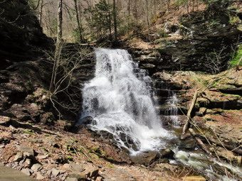
![]()
![]()
![]()
![]()
![]() On Wednesday, April 24th I decided I wanted to take of the nice weather and recent rains to take I some waterfalls. I decide to go to Rickett's Glen. Ricketts Glen is one of my favorite hiking spots in the northeast outside of New York. The Glens Natural Area is a National Natural Landmark with 22 named falls along a 7.3 mile loop trail. The falls vary in height from 11 feet to 94 feet and each has a different character. The weather report was for partly sunny skies with temperatures in the mid 60's. I wanted to arrive as early in the morning as I could so that I could return home for ambulance duty. Photographing the waterfalls in the glens can be tricky as too much sun makes the water too bright and not enough leaves the images too dark. The other drawback is that the area is so popular that there are usually a lot of people and many have elaborate photographic equipment. I was hoping that a Wednesday morning would limit the number of visitors. I asked Cindy if she wanted to go and she initially declined as she was tired. I had almost decided not to go but then changed my mind. When I told Cindy Sheila and I were going, she decided to come along! With the temperature forecast to reach into the 60's, I decided to make sure I was dressed in lighter clothes. I put on my long-sleeved light Columbia crew top with a short-sleeved baselayer. I knew this might be a little too warm but felt I could always remove a layer if needed. I put on a pair of RailRiders hiking pants which are expensive but last along time and have features like deep pockets and a generous cut which I really like. The pants have Velcro closures at the ankles. I decided to wear my Vasque Talus boots which are supportive and surprisingly roomy. I decided against my Mammut hoody and put on a very light windbreaker. I did add a pair of OR Bugout gaiters to combat the ticks. I got Sheila and our gear in the car and we left Livingston Manor just after 9:00 AM and headed over the back roads toward Honesdale. The entire trip takes between 2.5 and 3 hours with a stop along the way. The drive went pretty quickly and began to look more familiar as we got nearer to our destination. I avoided any wrong turns and arrived in the parking lot at 11:40 AM. The parking area had been completely redone which was a big improvement. There were only a few cars in the lot but I knew there were other parking areas to choose from. We got ready to hike and I set my GPS unit as we started out on the trail by 11:45 AM. The first 1.4 miles of the trail to Murray Reynolds Falls rolls a little but is almost flat. In general the trails were in good shape but there always seem to be some muddy spots and places where water flows over the trail. The traffic is so high that the rocks are worn smooth and can be very slippery even when dry. When the rocks are wet, muddy and have fallen leaves on them, they become a recipe for disaster unless hikers are careful. Signs warn about proper footwear and respect for the difficulty of the trail. The first part of the trail seemed longer than I remembered and we stopped a few times so I could rake a few pictures even though I knew the falls would be much more impressive. As we hiked we met a few people some hiking a lone and some in small groups. Most hikers were wearing appropriate footwear which was encouraging.
On Wednesday, April 24th I decided I wanted to take of the nice weather and recent rains to take I some waterfalls. I decide to go to Rickett's Glen. Ricketts Glen is one of my favorite hiking spots in the northeast outside of New York. The Glens Natural Area is a National Natural Landmark with 22 named falls along a 7.3 mile loop trail. The falls vary in height from 11 feet to 94 feet and each has a different character. The weather report was for partly sunny skies with temperatures in the mid 60's. I wanted to arrive as early in the morning as I could so that I could return home for ambulance duty. Photographing the waterfalls in the glens can be tricky as too much sun makes the water too bright and not enough leaves the images too dark. The other drawback is that the area is so popular that there are usually a lot of people and many have elaborate photographic equipment. I was hoping that a Wednesday morning would limit the number of visitors. I asked Cindy if she wanted to go and she initially declined as she was tired. I had almost decided not to go but then changed my mind. When I told Cindy Sheila and I were going, she decided to come along! With the temperature forecast to reach into the 60's, I decided to make sure I was dressed in lighter clothes. I put on my long-sleeved light Columbia crew top with a short-sleeved baselayer. I knew this might be a little too warm but felt I could always remove a layer if needed. I put on a pair of RailRiders hiking pants which are expensive but last along time and have features like deep pockets and a generous cut which I really like. The pants have Velcro closures at the ankles. I decided to wear my Vasque Talus boots which are supportive and surprisingly roomy. I decided against my Mammut hoody and put on a very light windbreaker. I did add a pair of OR Bugout gaiters to combat the ticks. I got Sheila and our gear in the car and we left Livingston Manor just after 9:00 AM and headed over the back roads toward Honesdale. The entire trip takes between 2.5 and 3 hours with a stop along the way. The drive went pretty quickly and began to look more familiar as we got nearer to our destination. I avoided any wrong turns and arrived in the parking lot at 11:40 AM. The parking area had been completely redone which was a big improvement. There were only a few cars in the lot but I knew there were other parking areas to choose from. We got ready to hike and I set my GPS unit as we started out on the trail by 11:45 AM. The first 1.4 miles of the trail to Murray Reynolds Falls rolls a little but is almost flat. In general the trails were in good shape but there always seem to be some muddy spots and places where water flows over the trail. The traffic is so high that the rocks are worn smooth and can be very slippery even when dry. When the rocks are wet, muddy and have fallen leaves on them, they become a recipe for disaster unless hikers are careful. Signs warn about proper footwear and respect for the difficulty of the trail. The first part of the trail seemed longer than I remembered and we stopped a few times so I could rake a few pictures even though I knew the falls would be much more impressive. As we hiked we met a few people some hiking a lone and some in small groups. Most hikers were wearing appropriate footwear which was encouraging.
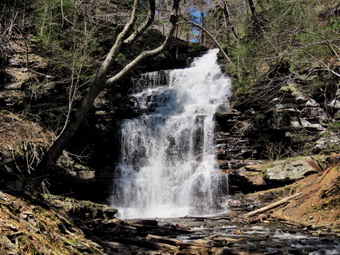 At one point the trail split with the more difficult route following low along the stream and the easier route heading up away from the water. The trails rejoins at the first falls. We stopped at Murray Reynolds and I took some pictures by walking down to the stream bed. The water had enough volume to make the falls interesting but not enough from preventing positioning for good shots. The sun was still low in the sky making the lighting good. The basic story of my hike was hike to the next falls, walk to the stream to find a good angle, wait for people to clear out, take pictures and repeat. A brochure at the trailhead has a great map and descriptions of the various falls. Each one is just a little different and many change with water volume. I stopped at the next two falls and took pictures at each. I looked for the signs that used to be posted at each falls but found many were missing. Even though we stopped frequently, we soon arrived at Watersmeet where Ganoga Glen and Glen Leigh meet. Just before Watersmeet, there was a UTV next to the trail. I could see the route the UTV used but there were no workers in the immediate area. We paused for a moment so that I could take some pictures and then headed up Ganoga Glen. We would then return by way of Glen Leigh. From this point on the trail got steeper and there were a number of wooden walkways and bridges. The first two falls we came to were Erie and Tuscarora both of which are 47 feet high and were roaring impressively. I took a lot of pictures of both falls which, of course, slowed us down. More information and descriptions of all the falls and maps of the park are available on the Pennsylvania Department of Conservation and Natural Resources website.
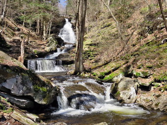 We hiked along saying "Hello" to various groups and talking to some of the people. We soon caught on to the fact that many of the people were parked at the northern end of the glens are were hiking down Ganoga Glen and back up Glen Leigh. I always prefer to hike Up and the way out and down on the way back! We made a slightly longer stop at 94 foot Ganoga Falls, the highest in the park. Many of the falls now have short, informal paths to the streambed at the base of the waterfall which makes taking unobstructed photography much easier. We continued to hike and stop for me to take pictures. By 2:00 PM we had hiked 3.4 miles and were at the top of Ganoga Glen. We turned right on the Highlands Trail to get to the trail through Glen Leigh. This trail is almost exactly a mile long and we began to meet more people as many had started up Glen Leigh or had parked at the upper Lake Rose parking area. We hiked quickly but this section of trail seemed longer than I remembered. We passed through Midway Crevasse but did not stop to take any pictures. This is the midway spot on the Falls Loop and is a narrow pathway between some rocks. We came to a shortcut path and turned right to follow it but soon decided we would return to the main trail. Soon the trail down Glen Leigh accreted on the right and we turned to hike down Glen Leigh. The first falls we came to was Onandaga and I stopped to take some shots. We repeated the sequence of hiking and taking pictures. At 3:00 PM we came to Ozone Falls which, at 60 feet high, is the send tallest falls in the glen area. Hiking down the slippery trails and stone steps was a little more unnerving than hiking up. I did not have my poles as I had Sheila on her leash most of the time. I did let her off several times to descend the steps as she could not help but pull me. By this time the sun was beginning to shine down into the glen making some scenes a little too bright for good exposures. I made a mental note to reverse my hiking direction next time!
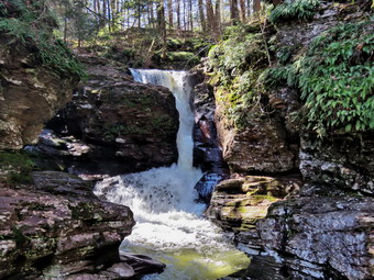 It wasn't very long before the trail began to flatten and the last few waterfalls came into view. There were several bridges that crossed and recrossed the stream and also provided a different perspective for picture taking. By 3:25 PM, we were back at Watersmeet after hiking 5.7 miles. We began the 1.7 mile walk back to the parking area. It was pleasant to just be able to hike without "worrying" about taking pictures. As I was headed toward the parking area there were still some people coming up then trail. It was hard to tell which groups were just beginning and which were turning to complete the loop. When we got to the point where the trail split, we headed to the right on the easier path back to the parking area. As we approached the bridge back to the parking area, Sheila and I continued across the road to visit Adams Falls while Cindy headed back to the car. Adams Falls is the last one in the park even though it is not in the glen area. This falls has made a deep cut in the rocks. There is a deep plunge pool at the end and it is evident that the stream has cut through the rock over the years. I thought about hiking the Evergreen Trail below this falls but decided against it as I was a little tired and knew I knew Cindy was waiting for me. I took pictures of the falls which was difficult do to the lighting. We turned around and walked back to the car and arriving at 4:15 PM having walked 7.5 miles in 4.5 hours with an ascent of over 1400 feet. On the way home we ran into some traffic near Scranton which helped me to stay awake!
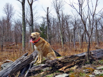
![]()
![]()
![]()
![]()
![]() On Tuesday, April 23rd I planned to hike a DEP parcel of land starting at Rehor Road just north of Tompkins Falls. This hike was inspired by James Hopson in a recent Facebook post. Cindy and I had hiked the first part of this route but I wanted to complete the hike. Lisa contacted me the day before and agreed that she would hike with me and that we would spot a car to shorten the hike by eliminating the road walk. This would mean a hike of about 5 miles. I couldn't start until after track practice in the morning so Lia and I agreed to meet at her house on Beaverkill Road and 11:15 AM. When I got up in the morning, it was already in the high 50's and I expected the temperature to rise throughout the day. I returned to track practice at 10:45 AM and began to get ready. Sheila knew that we were going hiking and kept an eye on us to make sure I would not forget her. With the temperature hovering around 70 degrees, I decided to make sure I was dressed in lighter clothes. I put on my long-sleeved light Columbia crew top with a short-sleeved baselayer. I knew this might be a little too warm but felt I could always remove a layer if needed. I put on a pair of RailRiders hiking pants which are expensive but last along time and have features like deep pockets and a generous cut which I really like. The pants have Velcro closures at the ankles. I decided to wear my Vasque Talus boots which are supportive and surprisingly roomy. I decided against my Mammut hoody and put on a very light windbreaker. I put a pair of light gloves in my pack more for the briars and to keep my hands warm. I did add a pair of OR Bugout gaiters to combat the ticks. I got Sheila and my gear in the car and I drove north on Old Route 17 to the Beaverkill Road where I turned right. I continued on the Beaverkill Road to the top, of the hill and pulled into Lisa's driveway at 11:15 AM. We were on our way almost immediately heading up the Beaverkill Road through Lew Beach and Turnwood for 10.8 miles to Barkaboom Road. We turned left and followed the road passing Big Pond. Just before Tompkins Falls, we found Deerlick Brook Road on the right. We turned right and drove up the road to the intersection with Minor Road. We turned around and parked Lisa's car in a pullout just down the road from the intersection. Lisa got in my car and I drove back to Barkaboom Road. I turned right and continued passed Tompkins falls and to Rehor Road on the right about 4.2 miles from Beaverkill Road. I pulled over and parked on the shoulder of the road at 11:45 AM. The temperature was 70 degrees as we got ready to hike so I left my windbreaker in the car. I set my THREE GPS units including my Garmin handheld unit, my Suunto Traverse watch and the Avenza app on my iPhone. We began the hike by starting up abandoned Rehor Road passing through the gate.
On Tuesday, April 23rd I planned to hike a DEP parcel of land starting at Rehor Road just north of Tompkins Falls. This hike was inspired by James Hopson in a recent Facebook post. Cindy and I had hiked the first part of this route but I wanted to complete the hike. Lisa contacted me the day before and agreed that she would hike with me and that we would spot a car to shorten the hike by eliminating the road walk. This would mean a hike of about 5 miles. I couldn't start until after track practice in the morning so Lia and I agreed to meet at her house on Beaverkill Road and 11:15 AM. When I got up in the morning, it was already in the high 50's and I expected the temperature to rise throughout the day. I returned to track practice at 10:45 AM and began to get ready. Sheila knew that we were going hiking and kept an eye on us to make sure I would not forget her. With the temperature hovering around 70 degrees, I decided to make sure I was dressed in lighter clothes. I put on my long-sleeved light Columbia crew top with a short-sleeved baselayer. I knew this might be a little too warm but felt I could always remove a layer if needed. I put on a pair of RailRiders hiking pants which are expensive but last along time and have features like deep pockets and a generous cut which I really like. The pants have Velcro closures at the ankles. I decided to wear my Vasque Talus boots which are supportive and surprisingly roomy. I decided against my Mammut hoody and put on a very light windbreaker. I put a pair of light gloves in my pack more for the briars and to keep my hands warm. I did add a pair of OR Bugout gaiters to combat the ticks. I got Sheila and my gear in the car and I drove north on Old Route 17 to the Beaverkill Road where I turned right. I continued on the Beaverkill Road to the top, of the hill and pulled into Lisa's driveway at 11:15 AM. We were on our way almost immediately heading up the Beaverkill Road through Lew Beach and Turnwood for 10.8 miles to Barkaboom Road. We turned left and followed the road passing Big Pond. Just before Tompkins Falls, we found Deerlick Brook Road on the right. We turned right and drove up the road to the intersection with Minor Road. We turned around and parked Lisa's car in a pullout just down the road from the intersection. Lisa got in my car and I drove back to Barkaboom Road. I turned right and continued passed Tompkins falls and to Rehor Road on the right about 4.2 miles from Beaverkill Road. I pulled over and parked on the shoulder of the road at 11:45 AM. The temperature was 70 degrees as we got ready to hike so I left my windbreaker in the car. I set my THREE GPS units including my Garmin handheld unit, my Suunto Traverse watch and the Avenza app on my iPhone. We began the hike by starting up abandoned Rehor Road passing through the gate.
 The road was wide and, although abandoned, seemed to be maintained. I had decided to follow the road as far as it went before starting out on a true bushwhack. The first .65 miles of the road climbs at about 12% which is not difficult but does get the blood flowing. The general direction is east and slightly northeast. At .65 miles the road turns 90 degrees to the left and at this point there is a small pond on the right. As we walked I pointed out some points of interest to Lisa. We followed the trail as it continued uphill making a slight turn to the right. At .8 miles we came to a left turn in the road and at this point there were some interesting stone walls. There had been many stone walls along the way and all were well-constructed and higher than many. The walls at the turn were even higher. At this point we decided to turn right off the trail to continue north. We worked our way up the hill and found a stone wall going up the hill with a road beside it. We followed the road using the principle of "go up". Since we knew we were looking for the highest point around, we simply kept going up. We were a little farther to the west than when Cindy and I had hiked and I began to correct for this. I adjust our route a little more to the northeast since both the map and the terrain seemed to indicate this was a good idea. As we walked we ran into several stands of briars but had to put up with them as there did not seem any way to avoid them. We came to the top of another small hill and looked around for some views of the Pepacton Reservoir. We couldn't find any. As we looked to the northeast, we could see some more high ground so we headed in that direction. We again ran into some prickers but I was able to find a route that had fewer of them and eventually led to an open field at the top of a subpeak! There were no real views but the open field was as surprising this time as the last time when I was hiking with Cindy. Near the top of the hill was a small structure that had collapsed. We took a break for a few minutes and then walked toward a stand of evergreen trees to the northeast. We found a woods road headed in that direction but it headed down and I knew we wanted to continue to the northeast and up to the top of the ridge. We walked along a "bridge" of land that fell off on both sides. After crossing an open patch with some briars, we entered the woods and did not have to deal with many briars for the rest of the trip. At this point, Lisa announced that she had left her keys in my car. I knew this would lengthen the hike but at least the walking would be on a flat road surface.
 We walked uphill toward the top of the west-east ridge and found the first of several different rock formations that were interesting. The rocks here showed very narrow bands of sedimentation so I took a few pictures before we moved on. We continued to the top of the ridge which was rather flat and at around 2.4 miles turned ESE to follow the ridge. The walking was mostly through open hardwood forest and easier than the briar patches we had encountered earlier. We hit a high point of a little over 2660 feet and then descended off the ridge before ascending to another bump. At 3.25 miles we turned southeast and continue to the highest point on this part of the ridge. There were some nice views to the north but it was impossible to get any good pictures. We did find a spot with two green plastic chairs! We continued to the highest point on the bump and then decided it was time to head down to Deerlick Brook Road. We turned south-southwest and started down a steep slope that averaged 18%. Along the way we found an impressive set of ledges and rock outcrops. We stopped so that I could take some pictures. I used Sheila to show the scale of the ledges. We continued down the hill until we could hear water and see the road. We worked our way around some springs that were flowing freely. I stopped to take a few shots of the springs and their outflow as everything was so green around them. We continued our hike out to the road crossing some small stream. Once on the road we turned right and headed west and then southwest following the road. We passed Minor Road and Lisa's car on the right. It was 1.5 miles to Barkaboom Road and the walk was pleasant. Deerlick Brook was flowing with crystal clear water and Sheila took a quick dip and got a drink. At Barkaboom Road I put Sheila on her leash, as we turned right and walked west-northwest toward the car. As we passed Tompkins Falls, a couple with a barking dog came up the bank. We passed by them and was glad for once that Sheila was not the most embarrassing dog around. I quickened my pace to stay ahead of them. I couldn't help but noticed how beautiful Barkaboom Brook was as it flowed over the rocks. At 4:00 PM we were back at the car after hiking 6.5 miles in 4 hours and 10 minutes. The elevation gain was 1437 feet. I considered hiking up to see the views from the hill above Rehor Road but a light rain was beginning to fall so I decided to leave that for another time. I drove Lisa back to her car and then headed home as the rain fell a little harder.
![]()
![]()
![]()
![]()
![]() On Wednesday, April 17th, I decided I wanted to hike a 3500 foot peak and Balsam Lake was as good as any. I had hiked the day before and was a little tired but the weather for the rest of the week included showers almost very day. I knew that I could not start until after morning track practice but knew that would be enough time to hike Balsam Lake even though I intended to hike from the Millbrook trailhead. An trip up the Beaverkill Road the week before had convinced me that the trailhead at the end of the road would not be accessible. I thought I might also hike Graham if time and energy permitted. When I returned from track practice at 11:30 AM, the temperature was 50 degrees but it felt warmer. Sheila knew that we were going hiking and kept and eye on me to make sure I would not forget her. Since the weather was already warm, I decided to dress accordingly. I put on a light Columbia long-sleeved crew top. I put on a pair of RailRiders hiking pants which are expensive but last along time and have features like deep pockets and a generous cut which I really like. The pants have Velcro closures at the ankles. I decided to wear my Vasque Talus boots which are supportive and surprisingly roomy. I decided against my Mammut hoody and put on a very light windbreaker. I put a pair of light gloves in my pack more for the briars and to keep my hands warm. I decided to wear a light hat. We left Livingston Manor just before noon as I drove west and north on Old Route 17 toward Roscoe. I turned right on the Beaverkill Road to drive through Lew Beach to Turnwood. Just before Turnwood, I turned left on Barkaboom Road and drove to the intersection with BWS 9. I turned right and after a short drive I turned right again onto Millbrook Road. The 8 mile drive along the road was pleasant and the temperature held at 55 degrees. I pulled into the parking area at 12:45 PM to find no other cars. When I got out of the car, there was a stiff breeze and I felt a little cold. I knew I would warm up on the hike but I worried that the temperature would drop as we climbed higher. I set my GPS device and then we crossed the road to start the hike. Sheila could hardly contain herself so I got her across the road quickly and onto the trail.
On Wednesday, April 17th, I decided I wanted to hike a 3500 foot peak and Balsam Lake was as good as any. I had hiked the day before and was a little tired but the weather for the rest of the week included showers almost very day. I knew that I could not start until after morning track practice but knew that would be enough time to hike Balsam Lake even though I intended to hike from the Millbrook trailhead. An trip up the Beaverkill Road the week before had convinced me that the trailhead at the end of the road would not be accessible. I thought I might also hike Graham if time and energy permitted. When I returned from track practice at 11:30 AM, the temperature was 50 degrees but it felt warmer. Sheila knew that we were going hiking and kept and eye on me to make sure I would not forget her. Since the weather was already warm, I decided to dress accordingly. I put on a light Columbia long-sleeved crew top. I put on a pair of RailRiders hiking pants which are expensive but last along time and have features like deep pockets and a generous cut which I really like. The pants have Velcro closures at the ankles. I decided to wear my Vasque Talus boots which are supportive and surprisingly roomy. I decided against my Mammut hoody and put on a very light windbreaker. I put a pair of light gloves in my pack more for the briars and to keep my hands warm. I decided to wear a light hat. We left Livingston Manor just before noon as I drove west and north on Old Route 17 toward Roscoe. I turned right on the Beaverkill Road to drive through Lew Beach to Turnwood. Just before Turnwood, I turned left on Barkaboom Road and drove to the intersection with BWS 9. I turned right and after a short drive I turned right again onto Millbrook Road. The 8 mile drive along the road was pleasant and the temperature held at 55 degrees. I pulled into the parking area at 12:45 PM to find no other cars. When I got out of the car, there was a stiff breeze and I felt a little cold. I knew I would warm up on the hike but I worried that the temperature would drop as we climbed higher. I set my GPS device and then we crossed the road to start the hike. Sheila could hardly contain herself so I got her across the road quickly and onto the trail.
 The lower part of the trail was free from snow and ice but I didn't know if this would continue all the way to the summit. I was still a little cold on the trail but I soon warmed up as we hiked. The trail register is a little over a quarter mile up the trail and it cam up quickly even though the trail was a little wet in places. I must admit that I didn't remember much of the hike in from this direction. The terrain was not as flat as I had remembered with about a 450 foot gain in the first mile. At this point the trail passes through a switchback and then continues to climb. Along the way I noticed what appeared to be a woods road head off to the left. It wasn't very distinct but I wondered if it could be the continuation of the upper road that forms part of the path to Graham. At some point I also noticed that the right side of the road was supported by laid up stone similar to that on the other side. This road used to connect the Beaverkill Valley to Millbrook and was well maintained. As we continued to gain elevation there was some ice on the rocks on the right side of the trail and I stopped to take a few shots. In another spot there was a small pocket of water on the left side of then trail with a small stream flowing into it. Sheila went over to get a drink and then started to dig at the pool of water. Farther up the trail we began to run into snow. At first the snow was only in the woods but then it started to cover parts of the trail. Sheila went and sat in the snow so I took some pictures. I then took some pictures of the trail with the snow and ice. The walk seemed long but at 2.1 miles we passed by the path to Graham and at 2.2 miles we turned right on the trail to the summit.
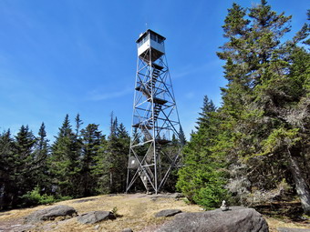 As I started up the mountain, I realized that I was a little tired and the trail was wet and muddy in spots which made the walk harder. Just after we made the turn, we met a family of four coming down from the summit. They were from the Millbrook side but were hiking from the Beaverkill trailhead while I was doing the opposite. As we continued to gain elevation, there was more and more snow on the trail. Some of the snow had drifted and had not yet melted. In other places, there was a spine of snow packed in the middle of the trail where most people walk. After the 3500 foot sign there was a pretty consistent layer of snow and ice up until the cabin. The last .7 miles is all uphill and gains about 425 feet to the clearing with the fire tower. As we approached the tower, the snow disappeared and the tower clearing was mostly free of snow except for some under the trees. It was 2:25 PM when we arrived and I dumped my pack at the picnic table. I got out my camera and leashed Sheila to the picnic table as I did not want her to follow me up the tower. I headed up the tower with my camera and as soon as I was above the level of the trees, the breeze hit me. I climbed to the landing just below the cab noticing that several pieces of protective screening were missing or loose. From the landing, I took a lot of shots including some through the tower. The skies were blue and there were a few wispy, white clouds. I took a few shots of Sheila and the descended the tower and walked over to the picnic table. I released Sheila and then got a bar and a drink. I put on my spikes for the descent and started back on the route we had used to get to the summit. I decided that it was late enough that I would not make the loop or try for Graham.
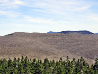 The trip down the mountain to the trail junction went quickly as I was able to get a good grip on the ice and not worry about falling. We turned left to return to the car. Once we passed the cutoff to Graham I knew that the trail was downhill all the way. We were making good time! At some point Sheila seemed to be more interested in playing in the snow by running up and down the trail through it. I thought we would make much better time on the way back but the trip out and back were taking about the same amount of time. The trail had been highly eroded by the recent anis leaving exposed stones which made the hiking more difficult. When we arrived back at the parking lot, there was another car present. We were back at the trail head by 4:10 PM having covered 6 miles in 3 hours and 20 minutes including the time at the tower. The temperature was in the low 60's as I drove away following the same route back home. On the Barkaboom Road, I considered stopping at Rehor Road and hiking to a viewpoint near the beginning of the old road. I decided that I was not interested in expending any more energy on this day. As we passed Tompkins Falls, I looked at the flow of water and decided it was no better than a week before when I got plenty of pictures.
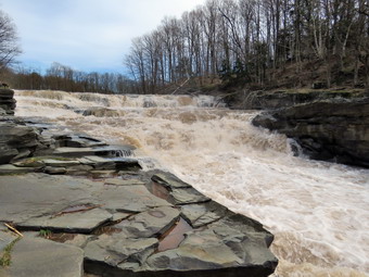
![]() On Tuesday, April 16th Cindy and I left Pratt Rock and headed east on Route 23. After a short drive, I turned left on Route 23A and drove north. Red Falls is impossible to miss on the right side of the road. I pulled over and parked on the side of the road. There are "No Parking" signs here so I never stay very long. This spot is popular with many young people and there is often garbage and broken bottles strewn about the area. The land is owned by the DEP and is open to the public. Cindy did not want to go to the falls and I decided to leave Sheila with her as the falls were as full as I had ever seen them. I walked to a short but steep path down the bank to the falls. I worked my way down the path to the edge of the falls. Much like the other waterfalls we had visited Red Falls was roaring with a high volume and rapidly flowing water. Fortunately, there was enough room on the rocks along the side of the falls to allow me to walk downstream. I took pictures of the falls as a whole from as far downstream as I dared go. The rocks were slippery and water was splashing onto them. I probably went a little too far but was able to keep my footing. I also took pictures of various parts of the falls and the water downstream. I started to work my way back up the rocks to the spot where I had come down to the creek. From there I walked back up the steep path to the car. We were all ready to return home after a day of visiting so many different attractions./p>
On Tuesday, April 16th Cindy and I left Pratt Rock and headed east on Route 23. After a short drive, I turned left on Route 23A and drove north. Red Falls is impossible to miss on the right side of the road. I pulled over and parked on the side of the road. There are "No Parking" signs here so I never stay very long. This spot is popular with many young people and there is often garbage and broken bottles strewn about the area. The land is owned by the DEP and is open to the public. Cindy did not want to go to the falls and I decided to leave Sheila with her as the falls were as full as I had ever seen them. I walked to a short but steep path down the bank to the falls. I worked my way down the path to the edge of the falls. Much like the other waterfalls we had visited Red Falls was roaring with a high volume and rapidly flowing water. Fortunately, there was enough room on the rocks along the side of the falls to allow me to walk downstream. I took pictures of the falls as a whole from as far downstream as I dared go. The rocks were slippery and water was splashing onto them. I probably went a little too far but was able to keep my footing. I also took pictures of various parts of the falls and the water downstream. I started to work my way back up the rocks to the spot where I had come down to the creek. From there I walked back up the steep path to the car. We were all ready to return home after a day of visiting so many different attractions./p>
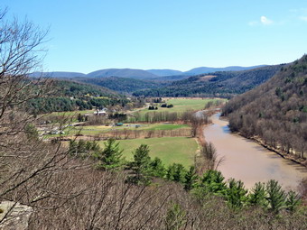
![]()
![]()
![]()
![]()
![]() On Tuesday, April 16th after visiting Vroman's Nose and several waterfalls, Cindy and I decided to go to hike at Pratt Rock just east of Prattsville. From Mine Kill Falls I drove west on Route 30 and turned left on Route 990V which passes by the newly reconstructed Schoharie Reservoir dam. The water was roaring over the dam but there is no good place to get a look at the dam. I continued east on Route 990V passing Gilboa-Conesville Central School. In Conesville, I turned right and headed south on the Prattsville Road. I drove slowly over the bridge to take a look at Manorkill Falls. The falls upstream from the bridge was interesting but I decided not to stop since access and a good place to the view the falls is limited. We continued south to Prattsvile and turned left on Route 23. I drove east on Route 23 to the parking area for Pratt Rock just outside of town. I turned into the small parking area on the left and found there were no other cars in the lot. We started our hike at 2:25 PM by walking on the path passing the information kiosk and continuing up the path around the "back" of the cliffs. As we passed the first bench carved into the rock, we could see some of the carvings much higher up on the cliffs. We decided to bypass the trail that goes to the base of the cliffs and continued to walk west and up the trail that goes to the top of the cliffs. The trail is a little steep in spots and is highly eroded since it is a popular destination. It was also wet and muddy in spots. We were soon at the top of the cliffs taking in the view of the sparkling Batavia Kill below. The water was high and the flow showed the power of the stream. There were no other hikers in sight so I took quite a few pictures of the valley below. The sun angle was again not very advantageous but I did get some nice shots. We continued to walk up to the next set of lookouts which are more to the east. The angle of the sun was better here so I took some more shots of the stream below, the valley and the hills beyond. To the northeast a high mountain was visible and I was pretty sure it was Huntersfield Mountain which is on the CHH list. I took some more pictures before we headed back down the trail and found a shortcut to the trail that runs just below the cliffs. This trail was a tricky little descent but brought us out just below the carvings. There were no others present so I got out the camera and took some pictures of the rock carvings. The whole area is beginning to show some neglect. The carvings are deteriorating and are not whitewashed frequently. It is most distressing that a few people have found it necessary to deface the carvings with graffiti. The carvings are a real artistic and historic treasure which are being ignored. When I was done with my photography, we descended the trail back to the car. We were at the car by 3:10 PM after covering the short hike of less than a mile. We were ready to head to one last destination which was Red Falls on Route 23A only a short distance away.
On Tuesday, April 16th after visiting Vroman's Nose and several waterfalls, Cindy and I decided to go to hike at Pratt Rock just east of Prattsville. From Mine Kill Falls I drove west on Route 30 and turned left on Route 990V which passes by the newly reconstructed Schoharie Reservoir dam. The water was roaring over the dam but there is no good place to get a look at the dam. I continued east on Route 990V passing Gilboa-Conesville Central School. In Conesville, I turned right and headed south on the Prattsville Road. I drove slowly over the bridge to take a look at Manorkill Falls. The falls upstream from the bridge was interesting but I decided not to stop since access and a good place to the view the falls is limited. We continued south to Prattsvile and turned left on Route 23. I drove east on Route 23 to the parking area for Pratt Rock just outside of town. I turned into the small parking area on the left and found there were no other cars in the lot. We started our hike at 2:25 PM by walking on the path passing the information kiosk and continuing up the path around the "back" of the cliffs. As we passed the first bench carved into the rock, we could see some of the carvings much higher up on the cliffs. We decided to bypass the trail that goes to the base of the cliffs and continued to walk west and up the trail that goes to the top of the cliffs. The trail is a little steep in spots and is highly eroded since it is a popular destination. It was also wet and muddy in spots. We were soon at the top of the cliffs taking in the view of the sparkling Batavia Kill below. The water was high and the flow showed the power of the stream. There were no other hikers in sight so I took quite a few pictures of the valley below. The sun angle was again not very advantageous but I did get some nice shots. We continued to walk up to the next set of lookouts which are more to the east. The angle of the sun was better here so I took some more shots of the stream below, the valley and the hills beyond. To the northeast a high mountain was visible and I was pretty sure it was Huntersfield Mountain which is on the CHH list. I took some more pictures before we headed back down the trail and found a shortcut to the trail that runs just below the cliffs. This trail was a tricky little descent but brought us out just below the carvings. There were no others present so I got out the camera and took some pictures of the rock carvings. The whole area is beginning to show some neglect. The carvings are deteriorating and are not whitewashed frequently. It is most distressing that a few people have found it necessary to deface the carvings with graffiti. The carvings are a real artistic and historic treasure which are being ignored. When I was done with my photography, we descended the trail back to the car. We were at the car by 3:10 PM after covering the short hike of less than a mile. We were ready to head to one last destination which was Red Falls on Route 23A only a short distance away.
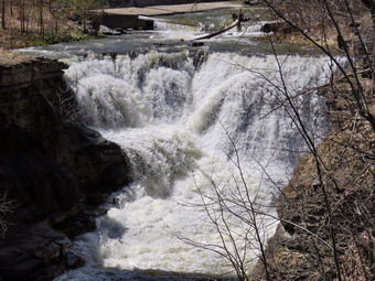
![]() On Tuesday, April 16th we were driving south and west on Route 30 after visiting Vroman's Nose and a few other spots. I had planned to visit some waterfalls in the area since I knew they would be roaring from recent rains. After passing by the Blenhiem-Gilboa Power Project, we came to the entrance for the parking lot for Mine Kill Falls on the left. I pulled into the parking area at 1:35 PM to find two other cars present. We knew the hike was short but I wanted to record a GPS track and take some pictures. I set my electronics and shouldered my pack. Since there were others enjoying the park, I put Sheila on her leash as we waked down the path toward the viewing platform. Just before the platform we turned right and I noted a couple coming up from the platform. We started to follow the trail down toward the base of the falls and never saw the other couple again. Either they had already been down the trail or had decided they did not want to walk to the base of the falls. The aqua blazes on the trail designated this as part of the Long Path. The trail was very wet and muddy in places as it wound down to the pool at the base of the falls. I dropped my pack and took out the camera to get some pictures of the falls. The lighting was poor as the sun was bright and shining directly on the water. The intermittent falls to the right of the main falls was flowing nicely. This falls has a higher drop than the main falls but a much lower volume. I was able to get pictures of the water as it flows between the rocks as well as shots of the lower falls as it spills into the pool. I also took pictures of the water falling from high off the cliffs. I took some more shots before we picked up and headed back up the trail. I followed the Long Path as it veered to the left and though that I did not remember hiking this section when I competed it. Later, by looking at my maps, it was obvious I had hiked it but from the other direction. We walked from the bottom of the falls back to the top and turned right to go to the viewing platform. There was no one else at the platform so I got out the camera and started to take pictures of the water flowing through the deep crevice in the rocks. I also took some pictures of another falls farther upstream just beyond the road bridge. This falls was flowing with a volume I had never seen before and it rivaled the lower falls for volume of water and noise. After I finished with my photography, we turned around and walked back to the car. I drove out to Route 30 and turned left to head toward Prattsville and Pratt Rock.
On Tuesday, April 16th we were driving south and west on Route 30 after visiting Vroman's Nose and a few other spots. I had planned to visit some waterfalls in the area since I knew they would be roaring from recent rains. After passing by the Blenhiem-Gilboa Power Project, we came to the entrance for the parking lot for Mine Kill Falls on the left. I pulled into the parking area at 1:35 PM to find two other cars present. We knew the hike was short but I wanted to record a GPS track and take some pictures. I set my electronics and shouldered my pack. Since there were others enjoying the park, I put Sheila on her leash as we waked down the path toward the viewing platform. Just before the platform we turned right and I noted a couple coming up from the platform. We started to follow the trail down toward the base of the falls and never saw the other couple again. Either they had already been down the trail or had decided they did not want to walk to the base of the falls. The aqua blazes on the trail designated this as part of the Long Path. The trail was very wet and muddy in places as it wound down to the pool at the base of the falls. I dropped my pack and took out the camera to get some pictures of the falls. The lighting was poor as the sun was bright and shining directly on the water. The intermittent falls to the right of the main falls was flowing nicely. This falls has a higher drop than the main falls but a much lower volume. I was able to get pictures of the water as it flows between the rocks as well as shots of the lower falls as it spills into the pool. I also took pictures of the water falling from high off the cliffs. I took some more shots before we picked up and headed back up the trail. I followed the Long Path as it veered to the left and though that I did not remember hiking this section when I competed it. Later, by looking at my maps, it was obvious I had hiked it but from the other direction. We walked from the bottom of the falls back to the top and turned right to go to the viewing platform. There was no one else at the platform so I got out the camera and started to take pictures of the water flowing through the deep crevice in the rocks. I also took some pictures of another falls farther upstream just beyond the road bridge. This falls was flowing with a volume I had never seen before and it rivaled the lower falls for volume of water and noise. After I finished with my photography, we turned around and walked back to the car. I drove out to Route 30 and turned left to head toward Prattsville and Pratt Rock.
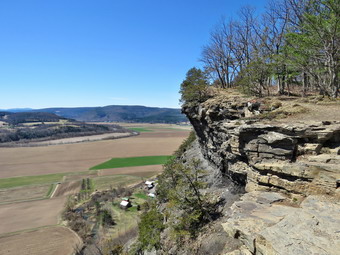
![]()
![]()
![]()
![]() On Tuesday, April 16th I knew that I had to get out for a hike after the heavy rain on Monday. I wanted to try to pick a trail that would be relatively dry and thought about hiking Balsam Lake Mountain and Graham from the Millbrook trailhead. I knew the Beaverkill Road had been nearly impassible the week before and that the heavy rains would have made it worse. I asked Cindy if she wanted to go and she said she did not want to hike mountains. I thought about going to see some waterfalls knowing they should be roaring and decided that heading north to Vroman's Nose, Mine Kill Falls, Pratt Rock and Red Falls would be just the thing. Cindy agreed but had some work to do before we could get going. The temperature on the back porch was 50 degrees in the sun but stepping outside told another story. Sheila was very happy to be getting out as we got dressed, packed our gear and got ready to go. The temperatures were forecast to be in the low 50's but with a wind speed of 15 mph most of the day so I dressed accordingly. I put on my Mammut long-sleeved crew top with a long-sleeved baselayer. I put on my pair of Columbia Omniheat hiking pants which have a reflective lining. I decided against a baselayer under the pants as I thought that would be too warm. I decided to put on a pair of OR Crocodile gaiters anyway. I wore my Vasque Talus hiking boots which are supportive especially with third-party insole. I wore a light hat and threw a pair of gloves in the pack. We left Livingston Manor at 10:15 AM and I set the car's GPS for Middleburgh. The route it suggested was State Route 17 to Roscoe and then Route 206 to Route 30 at the Pepacton Reservoir. I made a right on Route 30 and then followed it along the reservoir to Margaretville and then through Roxbury and Grand Gorge to Middleburgh. Just outside of Middleburgh I turned left on Mill Valley Road. Less than a mile up the road I parked in the Vromans Nose parking lot on the left side of the road. The association that maintains the area had increased the parking lot to more than double its size! There were only a few other cars in the lot when we left to start our hike at 11:55 AM. Some people left just ahead of us so I left my poles in the car and put Sheila on her leash. It was obvious that the trail was going to be wet and muddy from what we found as we walked through the gate. As we walked through the open field that leads to the trails, we found the trail to the right was still closed to allow the "old" trail to recover from overuse. We turned to the left to hike the steeper side first which would allow us to return on the gentle side. As we turned onto the yellow blazed trail I noted that it did not seem familiar and I questioned whether or not I was on the correct path but I soon realized it was just that I was traveling in a direction I had only taken once before. My intention was to continue on the yellow path all the way to the top passing the Long Path as we went. We came to the more gentle trail that comes in from the right at .2 miles but decided to climb the steeper trail and continued straight ahead. The half mile from where we entered the trail to the top averaged about an 18% grade. The only people we passed were some returning on the more gentle trail after visiting the top.
On Tuesday, April 16th I knew that I had to get out for a hike after the heavy rain on Monday. I wanted to try to pick a trail that would be relatively dry and thought about hiking Balsam Lake Mountain and Graham from the Millbrook trailhead. I knew the Beaverkill Road had been nearly impassible the week before and that the heavy rains would have made it worse. I asked Cindy if she wanted to go and she said she did not want to hike mountains. I thought about going to see some waterfalls knowing they should be roaring and decided that heading north to Vroman's Nose, Mine Kill Falls, Pratt Rock and Red Falls would be just the thing. Cindy agreed but had some work to do before we could get going. The temperature on the back porch was 50 degrees in the sun but stepping outside told another story. Sheila was very happy to be getting out as we got dressed, packed our gear and got ready to go. The temperatures were forecast to be in the low 50's but with a wind speed of 15 mph most of the day so I dressed accordingly. I put on my Mammut long-sleeved crew top with a long-sleeved baselayer. I put on my pair of Columbia Omniheat hiking pants which have a reflective lining. I decided against a baselayer under the pants as I thought that would be too warm. I decided to put on a pair of OR Crocodile gaiters anyway. I wore my Vasque Talus hiking boots which are supportive especially with third-party insole. I wore a light hat and threw a pair of gloves in the pack. We left Livingston Manor at 10:15 AM and I set the car's GPS for Middleburgh. The route it suggested was State Route 17 to Roscoe and then Route 206 to Route 30 at the Pepacton Reservoir. I made a right on Route 30 and then followed it along the reservoir to Margaretville and then through Roxbury and Grand Gorge to Middleburgh. Just outside of Middleburgh I turned left on Mill Valley Road. Less than a mile up the road I parked in the Vromans Nose parking lot on the left side of the road. The association that maintains the area had increased the parking lot to more than double its size! There were only a few other cars in the lot when we left to start our hike at 11:55 AM. Some people left just ahead of us so I left my poles in the car and put Sheila on her leash. It was obvious that the trail was going to be wet and muddy from what we found as we walked through the gate. As we walked through the open field that leads to the trails, we found the trail to the right was still closed to allow the "old" trail to recover from overuse. We turned to the left to hike the steeper side first which would allow us to return on the gentle side. As we turned onto the yellow blazed trail I noted that it did not seem familiar and I questioned whether or not I was on the correct path but I soon realized it was just that I was traveling in a direction I had only taken once before. My intention was to continue on the yellow path all the way to the top passing the Long Path as we went. We came to the more gentle trail that comes in from the right at .2 miles but decided to climb the steeper trail and continued straight ahead. The half mile from where we entered the trail to the top averaged about an 18% grade. The only people we passed were some returning on the more gentle trail after visiting the top.
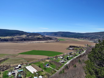 Soon we arrived at the top and I immediately began to take pictures. The fields below were much greener than at home and the Schoharie Creek was swollen with water. At the very first lookout I took pictures in all directions including some of the crumbling rock that makes up the Nose. I decided to bypass a few of the lookouts along the way as the view is better from the top. I took a few pictures of Sheila and Cindy and then continued on the trail. The aqua blazes indicated this is the route of the Long path, a hiking trail that runs form New York City to Albany. Once on the summit I dropped my pack and got out the camera as Cindy took over holding Sheila's leash. I was a little disappointed as the sky was a solid blue with no clouds. A slight haze hung over the Catskills in the distance. I still took some pictures concentrating on the farmland below with alternating patches of green and brown. I also took some shots along the edge of the cliffs. Vromans Nose has an elevation of about 1220 feet above sea level which makes it about 500 feet higher than the surrounding plain. It isn't very high but it gives a great view of the plain below and the peaks both near and far. We continued our hike by walking along the edge of the cliff. We stopped at the far end of the cliffs where I again took some more shots concentrating on the hills to the north and the bends in the Schoharie Creek below. The descent starts out a little steep and slippery but soon become a wide path with a gentler slope. We passed the point where the Long Path comes up on the left. This is a very steep ascent which I made when I hiked the Long Path. The trail back was a mess with water and mud covering the trail from side to side almost all the way back. At this rate this trail will have to be closed to allow it to "rest". We turned right at 1.1 miles and continued to follow the trail as it looped back to the trail we used at the start of the hike. At 1.4 miles we turned left and hiked back to the car. We were back at the car 1:00 PM having hiked 1.6 miles in 1 hour and 5 minutes with an elevation gain of 500 feet. We got in the car and drove south and west on Route 30 toward Mine Kill Falls
 As long as we were on Route 30, I decided to stop at a few places along the way. As we passed many flat fields on Route 30, we came to a small cemetery on the right. I pulled over as I had almost stopped where several times. A monument dedicated to a Jacob Hager caught my attention. The cemetery had about a dozen grave markers all dedicated to the Hager family. Jacob Hager had fought in the American Revolution in battles against Joseph Brandt in the Schoharie Valley. I took some pictures and then got back in the car to continue the journey.
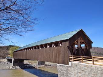 On the drive to Vroman's Nose we had noticed that, to our complete surprise, the covered bridge in North Blenheim had been replaced. The bridge was the world's longest covered bridge at 210 feet and had an unusual double-barreled configuration with two different "lanes" separated by a divider. On August 28, 2011 Tropical Storm Irene caused Schoharie Creek to flood and the bridge was washed away. After several years of "negotiations", the reconstruction of the bridge began in 2017 and was finished in late 2018 at a total cost of nearly 7 million dollars! I pulled into the parking area near the bridge and got out with my camera to take some pictures. The bridge is an entirely new construction but I could see that it was as close to the historic bridge as possible. The same construction techniques were used with more modern materials and the bridge was raised between 10 and 15 feet to, hopefully, avoid the disaster that occurred in 2011. I walks the length of the bridge and back taking pictures as I went. I also took pictures of the entrance and some from the side. When I was done, I returned to the car and got back on Route 3o heading east.
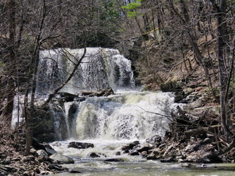 There was one more stop I wanted to make before Mine Kill Falls. As we approached the Blenheim-Gilboa Reservoir, I turned right on Creamery Road and turned around at the end of the street. The Long Path goes down this road and passes by a cemetery and then into the woods. I parked along the right side of street with Mill Brook Falls in full view. I got out of the car and grabbed my camera to take a few pictures of the falls that were flowing nicely with high volume. Mill Creek Falls forms on Mill Creek as it flows southeast and empties into the West Kill. In the summer the falls is only a trickle and the West Kill a lazy stream. It is a popular place for children to go to get cool on a hot summer's day. On this day the West Kill was very high and flowing very fast. The falls were thundering as they spilled into the stream below. I took a few shots and then returned to the car. I drove south again on Route 30 as our next stop was Mine Kill Falls.
On Sunday, April 14th I wanted to get in a hike after church and before the rains started. I had missed hiking Saturday as I had an all-day track meet and Monday's forecast called for rain all day. As we drove home, I asked Cindy if she wanted to hike but she refused my offer. I really don't like hiking alone with Sheila but I often don't have much choice as Cindy often turns me down. I decided that despite the late start and threat of rain, I would check out a ridge near the Cannonsville Reservoir west of Walton on Route 10. This ridge includes some 2000 foot peaks including Clabber, Middle Clabber and Speedwell. The ridge is mostly on DEC land which has some woods roads but no marked trails. I thought at the very least I could check out the area to setup a hike for a later date. I started getting ready just after 1:00 PM when the temperature was just below 70 degrees! Sheila knew that we were going hiking and kept and eye on us to make sure we would not forget her. Since the weather was already warm, I decided to dress accordingly. I put on a light Columbia long-sleeved crew top. I put on a pair of RailRiders hiking pants which are expensive but last along time and have features like deep pockets and a generous cut which I really like. The pants have Velcro closures at the ankles. I decided to wear my Keen Glarus hiking boots which are my "go to" hiking boots but are showing some wear. I decided against my Mammut hoody and put on a very light windbreaker. I put a pair of light gloves in my pack more for the briars and to keep my hands warm. I got Sheila and my gear in the car and drove out to State Route 17 and headed north toward Hancock. I passed an MVA in our ambulance territory that I had missed while at church. I was upset that I was not available and that no one else on our ambulance corps desponded to this emergency which was serious enough to require a helicopter. I continued on the Quickway to exit 87A where I picked up Route 268 North toward the Cannonsville. As I drove, the skies continued to darken and I seriously questioned whether or not I should even start the hike. At the intersection with Route 10, I turned left and headed west passing by Dryden Broook Road and Chamberlain Brook Road. I had an idea where I might start from a Facebook post by another hiker. I turned around And parked on the opposite shoulder of the road at 2:00 PM. When I got out of the car, I almost got back in as the wind had picked up and the skies were dark. I decided that as long as I was hiking uphill, I could hike back to the car pretty fast. I set my GPS unit and Sheila and I crossed the road to start our hike.
I found a path up to a clearing and continued to head uphill and north. We crossed a right-of-way and then picked up a wood road that seemed to be headed in the right direction. The road was overgrown but easy to follow. The wind continued to blow and I made myself a promise that I would turn around if the rain started. I continued to check our route with my GPS and was annoyed that I had left my compass at home since it is much easier to use. The woods road crossed another road or right-of way as it wound its way up the hill. We crossed several brooks and the the road seemed to turn a little too much to the north and started to descend. I decided to follow it a little farther as it seemed to turn uphill a little farther ahead. I also saw a structure ahead that I wanted to investigate. At that moment the rain started first as a shower and then as something more. I turned around and started back intending to follow the same route we had taken in the way out. It was pretty easy to follow the road we had followed out and Sheila was ahead of me following the track. As we neared the end we followed a slightly different route but ended up back at the car at 2:50 PM after hiking only 1.5 miles. Of course, the rain had almost stopped. I decided to follow the same route back home and by the time I reached Route 268 it was pouring! When I got home I placed the track on my BaseCamp software to check our progress and to plan for next time. It was clear that the other hiker whose route I was following had not hit what is marked on the map as Clabber Peak. I was glad I had checked since Clabber Peak is a little farther north than I was headed. I planned a route for a future date starting where I was parked and continuing to Clabber Peak. After hitting Clabber, I intend to head south along the ridge passing over Middle Clabber and another bump before getting to Speedwell which is at the southernmost end of this ridge. I intend to work my way down to Route 10 and then back to the car.
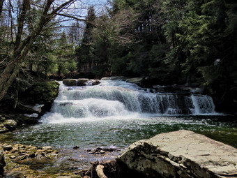
![]()
![]()
![]()
![]()
![]() On Sunday, April 7th, I wanted to get in a hike after church. I knew Cody would not be willing to hike two days in a row so the choice was up to me. I tried to think of a trail that might not be too muddy and came up with the hike from Alder lake to the Beaver Meadow leanto. When We got home from church, I immediately started to get ready trying to account for the 62 degree temperature at the house. I got dressed in my Mammut long-sleeved crew top with no baselayer. I put on a pair of RailRiders hiking pants which are expensive but last along time and have features like deep pockets and a generous cut which I really like. The pants have Velcro closures at the ankles but I decided to put on a pair of OR Crocodile gaiters anyway. I decided to wear my Keen Glarus hiking boots which are my "go to" hiking boots but are showing some wear. Sheila would not let me leave her sight and seemed ecstatic that we are hiking two days in a row. I got my gear and Sheila in the car and headed up the Beaverkill Road somewhere around 1:00 PM. I headed toward Turnwood and Alder Creek Road. On the way I began to think it would be a good idea to hike to the fire tower on Balsam Lake Mountain. I passed by Alder Creek Road and continued on the Beaverkill Road passing Quill Gordon Lodge and Bevaerkill Falls. The road began to get very rough with potholes an deep ruts but I persisted thinking I would just drive slowly. Just before the Zen monastery there was a "Rough Road" sign and I decided to give up and return to Alder Lake. I turned around and drove back down the road. Near Bevaerkill Falls I pulled over and took out my camera. I walked down to a viewpoint for the falls and took some pictures. The sun was at a bad angle but I thought I got a few good shots. I returned to the car and drove to Alder Creek Road where I turned right and drove to the Alder Lake parking lot. The gate was open and I parked at 1:30 PM. There were a few cars in the lot as I set my GPS devices: Garmin handheld, Avenza on the iPhone and Suunto Traverse watch. We started out at 1:32 PM by walking the path passed the Coykendall Mansion. As we walked, I could hear the sound of a machine and found a motorcycle in front of the ruins. It really didn't surprise me as I know many people feel that rules are not meant for them! We headed down to the "lawn" passing by the stone foundations which marked the last remnants of the Coykendall Mansion. We stopped so that I could take some pictures of the lake which still had a covering of ice. The trees looked bare but there was hint of leaf buds on some. The sky was blue with puffy white clouds.
On Sunday, April 7th, I wanted to get in a hike after church. I knew Cody would not be willing to hike two days in a row so the choice was up to me. I tried to think of a trail that might not be too muddy and came up with the hike from Alder lake to the Beaver Meadow leanto. When We got home from church, I immediately started to get ready trying to account for the 62 degree temperature at the house. I got dressed in my Mammut long-sleeved crew top with no baselayer. I put on a pair of RailRiders hiking pants which are expensive but last along time and have features like deep pockets and a generous cut which I really like. The pants have Velcro closures at the ankles but I decided to put on a pair of OR Crocodile gaiters anyway. I decided to wear my Keen Glarus hiking boots which are my "go to" hiking boots but are showing some wear. Sheila would not let me leave her sight and seemed ecstatic that we are hiking two days in a row. I got my gear and Sheila in the car and headed up the Beaverkill Road somewhere around 1:00 PM. I headed toward Turnwood and Alder Creek Road. On the way I began to think it would be a good idea to hike to the fire tower on Balsam Lake Mountain. I passed by Alder Creek Road and continued on the Beaverkill Road passing Quill Gordon Lodge and Bevaerkill Falls. The road began to get very rough with potholes an deep ruts but I persisted thinking I would just drive slowly. Just before the Zen monastery there was a "Rough Road" sign and I decided to give up and return to Alder Lake. I turned around and drove back down the road. Near Bevaerkill Falls I pulled over and took out my camera. I walked down to a viewpoint for the falls and took some pictures. The sun was at a bad angle but I thought I got a few good shots. I returned to the car and drove to Alder Creek Road where I turned right and drove to the Alder Lake parking lot. The gate was open and I parked at 1:30 PM. There were a few cars in the lot as I set my GPS devices: Garmin handheld, Avenza on the iPhone and Suunto Traverse watch. We started out at 1:32 PM by walking the path passed the Coykendall Mansion. As we walked, I could hear the sound of a machine and found a motorcycle in front of the ruins. It really didn't surprise me as I know many people feel that rules are not meant for them! We headed down to the "lawn" passing by the stone foundations which marked the last remnants of the Coykendall Mansion. We stopped so that I could take some pictures of the lake which still had a covering of ice. The trees looked bare but there was hint of leaf buds on some. The sky was blue with puffy white clouds.
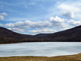 I packed up and decided to walk the trail around the lake in the opposite direction I normally choose. We turned right and walked over the dam and followed the path toward some campsites. I began to notice that the trail was poorly marked and I chose a lower path. We walked a short distance and then joined the actual trail. I noticed that there were signs indicating the campsite were closed as they had deteriorated from overuse. I wondered if this would make any difference to the campers who come to the lake in the summer! The trail was wet and muddy in spots and the farther east we walked the more snow we began to encounter. I was pleasantly surprised that the DEC had replaced the bridge that was broken and stopped to take a picture. We continued on the trail and crossed over the bridge over Alder Creek. I saw a fisherman approaching and put Sheila on her leash until we had passed him. We continued to walk and I could see a couple approaching. At that point a trail turned to the right and it looked like the Millbrook Ridge Trail. There was no sign and no blazes but I knew it was the trail we wanted. We turned right and started out on the trail. We had to walk a good distance before I saw one faded blaze. Ever since the DEC declared that volunteers are no competent to place blazes the trail markings in the Catskills have deteriorated. What a shame that the blazes are becoming less distinct as more and more people are frequenting the trails! I am not sure who the DEC has designated to mark the trails but they are not getting the job done. The trail was wet and muddy in many places and there were both old and new blowdowns to contend with. Some of the blowdowns had been cut but whoever did the cutting left what they cut in the trail! Others were cut in several, places but the job was left incomplete. I was almost sorry I did not have my saws but decided this was work for another day. I thought it would be nice to find out who the maintainer is for the trail and offer to help. For the next 1.5 miles the trail climbs and then levels off several times. The elevation gain is several hundred feet but the grade is never more than 12% and averages around 6%. There isn't too much to see along the way but this day was very pleasant. I enjoyed the sounds and sights of Alder Creek as it flows parallel to the trail much of the way. The further along the trail we walked the more snow was on the trail and in the forest. In one spot there was a large beaver dam on the left. There was a lot of water in Alder Creek and in the small triturates flowing across the trail. We passed by the first beaver meadow and continued hiking toward our destination.
 Soon we arrived at the Beaver Meadow lean-to. We walked down to the lean-to and I dropped my pack and got out the camera. I noticed that the privy was now completely torn apart by thoughtless campers looking for some firewood. One person starts the vandalism and the rest join in! It had taken only an hour an 15 minutes to get to the beaver meadow even though we had stopped several times to clear the trail and take pictures. We walked out to the edge of the beaver meadow where there is a large flat rock and I took pictures of the meadow. There was still quite a bit of snow on the edges and the skies were now much more overcast. We went back to the lean-to and I got a drink and a bar. I took some pictures of the lean-to which is in terrible shape and wondered who makes the decisions on what lean-tos need repair or replacement. At 2:45 PM we started back to Alder Lake. I knew the trip back would be easier since it was all downhill or flat. We walked almost without stopping until we arrived at the Loop Trail around the lake. We turned right and started along the northern shore of the lake. I remembered that there had been some beaver dams that caused flooding of the trail and wondered if they were still in place. We crossed the first ridge and I could see a fisherman on the second. I Put Sheila on her leash and stopped to take a picture of a cherry tree that the beavers were working on felling. I also took pictures of an extensive series of dams which they had constructed and which will flood the trail in time. I like beavers but these guys need to control themselves. As we passed the fisherman, we struck up a conversation. He really wanted to talk but I wanted to get home so I excused myself. We continued along the trail with one stop to take a few shots of Cradle Rock Ridge. We hiked up the lawn and passed the mansion. I decided I had enough pictures of the mansion and walked back to the car. It was 3:55 PM and head had hiked 4.6 miles in 2 hours and 20 minutes with several stops. The elevation gain was a modest 665 feet.
![]()
![]()
![]()
![]()
![]() On Saturday, April 6th I planned to hike a DEP parcel of land starting at Rehor Road just north of Tompkins Falls. This hike was inspired by James Hopson in a recent Facebook post. My intent was to follow his route but hike a loop rather than using a car spot. This would mean a hike about 8 miles long rather than 5 miles. I knew this would be too long for Cindy if she came along so I contacted the caretaker of the property on Minor Road. It wasn't easy but I finally got in contact and received to hike down to Minor Road and out to Deerlick Road. When I got up in the morning it was already in the high 30's but there was still a light drizzle falling and a heavy fog in the valley. I knew we would wait until late morning to begin to hike since the skies were supposed to clear and the temperature was forecast to rise. I did some chores including going to the local landfill. Finally, we began to get ready around 10:00 AM when the skies were still cloudy, the fog was still hanging around and the temperature had only risen a few degrees. Sheila knew that we were going hiking and kept and eye on us to make sure we would not forget her. Although the forecast was for warmer temperatures, I decided to dress in layers. I put on my long-sleeved Mammut crew top with a long-sleeved baselayer. I knew this might be a little too warm but felt I could always remove a layer if needed. I put on a pair of light tights under my Columbia Omniheat hiking pants which have a reflective lining. The pants have Velcro closures at the ankles which I hoped would fend off any ticks which might be out in the warmer weather. I donned my Mammut hoody which has enough zippers to dump heat if needed. I put on a light hat and gloves. I put on my Salomon B-52 winter hiking boots which are waterproof and warm. They don't have as much support as my regular boots but I was not planning on hiking over 10 miles! I did put on a pair of OR Crocodile gaiters. We had decided to take our spikes but to forgo the snowshoes. We got Sheila and our gear in the car and I drove north on Old Route 17 to the Beaverkill Road where I turned right. I continued on the Beaverkill Road through Lew Beach and Turnwood for 10.8 miles to Barkaboom Road. I turned left and followed the road passing Big Pond which was still covered in ice. Just before Tompkins Falls, we found Deerlick Brook Road on the right. I continued passed Tompkins falls and began to look for Rehor Road on the right. We cam to a road that looked promising. It was not marked but had a gate with a DEP sign. I check my Avenza app and found we were in the right place. The distance from Beaverkill Road was about 4.2 miles. I pulled over and parked on the shoulder of the road at 11:30 AM. The temperature was 39 degrees as we got ready to hike. I set my THREE GPS units including my Garmin handheld unit, my Suunto Traverse watch and the Avenza app on my iPhone. We began the hike by starting up abandoned Rehor Road passing through the gate.
On Saturday, April 6th I planned to hike a DEP parcel of land starting at Rehor Road just north of Tompkins Falls. This hike was inspired by James Hopson in a recent Facebook post. My intent was to follow his route but hike a loop rather than using a car spot. This would mean a hike about 8 miles long rather than 5 miles. I knew this would be too long for Cindy if she came along so I contacted the caretaker of the property on Minor Road. It wasn't easy but I finally got in contact and received to hike down to Minor Road and out to Deerlick Road. When I got up in the morning it was already in the high 30's but there was still a light drizzle falling and a heavy fog in the valley. I knew we would wait until late morning to begin to hike since the skies were supposed to clear and the temperature was forecast to rise. I did some chores including going to the local landfill. Finally, we began to get ready around 10:00 AM when the skies were still cloudy, the fog was still hanging around and the temperature had only risen a few degrees. Sheila knew that we were going hiking and kept and eye on us to make sure we would not forget her. Although the forecast was for warmer temperatures, I decided to dress in layers. I put on my long-sleeved Mammut crew top with a long-sleeved baselayer. I knew this might be a little too warm but felt I could always remove a layer if needed. I put on a pair of light tights under my Columbia Omniheat hiking pants which have a reflective lining. The pants have Velcro closures at the ankles which I hoped would fend off any ticks which might be out in the warmer weather. I donned my Mammut hoody which has enough zippers to dump heat if needed. I put on a light hat and gloves. I put on my Salomon B-52 winter hiking boots which are waterproof and warm. They don't have as much support as my regular boots but I was not planning on hiking over 10 miles! I did put on a pair of OR Crocodile gaiters. We had decided to take our spikes but to forgo the snowshoes. We got Sheila and our gear in the car and I drove north on Old Route 17 to the Beaverkill Road where I turned right. I continued on the Beaverkill Road through Lew Beach and Turnwood for 10.8 miles to Barkaboom Road. I turned left and followed the road passing Big Pond which was still covered in ice. Just before Tompkins Falls, we found Deerlick Brook Road on the right. I continued passed Tompkins falls and began to look for Rehor Road on the right. We cam to a road that looked promising. It was not marked but had a gate with a DEP sign. I check my Avenza app and found we were in the right place. The distance from Beaverkill Road was about 4.2 miles. I pulled over and parked on the shoulder of the road at 11:30 AM. The temperature was 39 degrees as we got ready to hike. I set my THREE GPS units including my Garmin handheld unit, my Suunto Traverse watch and the Avenza app on my iPhone. We began the hike by starting up abandoned Rehor Road passing through the gate.
 The road was wide and, although abandoned, seemed to be maintained. I had decided to follow the road as far as it went before starting out on a true bushwhack. We stopped so that I could take some pictures of the road which was covered with a layer of snow. The snow made walking a little difficult but we made good time. The first .65 miles of the road climbs at about 12% which is not difficult but does get the blood flowing. The general direction is east and slightly northeast. At .65 miles the road turns 90 degrees to the left and at this point there is a small pond on the right. I walked down to the shore of the pond to take a few pictures before turning to the main trail. We followed the trail as it continued uphill making a slight turn to the right. At .8 miles we came to a left turn in the road and at this point there were some interesting stone walls. There had been many stone walls along the way and all were well-constructed and higher than many. The walls at the turn were even higher and I took some pictures. At this point we decided to turn right off the trail to continue north. We worked our way up the hill and found a stone wall going up the hill with a road beside it. We followed the road using the principle of "go up". Since we knew we were looking for the highest point around, we simply kept going up. The road leveled and seemed end at in a more open spot which looked familiar from some pictures I had seen. I took some shots and we decided to adjust our route a little more to the northeast since both the map and the terrain seemed to indicate this was a good idea. As we walked we ran into several stands of briars but had to put up with them as there did not seem any way to avoid them. We came to the top of another small hill and looked around for some views of the Pepacton Reservoir. We couldn't find any and we both remarked that if there were views we probably wouldn't see anything anyway as it was still cloudy with fog. As we looked to the northeast, we could see some more high ground so we headed in that direction. We again ran into some prickers but I was able to find a route that had fewer of them and eventually led to an open field at the top of a subpeak! There were no real views but the open field was surprising and we thought that someone must have been clearing it as the trees had not been able to reclaim the area. I put my pack down and took a few shots down the hill as Cindy approached. I noticed that there seemed to be a road heading in that direction. Near the top of the hill was a small structure that had collapsed and I took some picture of it. I walked farther up the hill and a little to the hoping to get a view of the reservoir but there was none.
 We had to make a decision about the rest of the hike. I wanted to continue northeast to another ridge to see if we could get some views. I knew this would lengthen the hike and was pretty sure it would be more than Cindy would want to do. She agreed and we decided to see if we could find a way to shorten the hike. I was not too disappointed since the hike had been a good way to explore the area and set up the next hike. We decided to head down the hill to the southwest following what looked like a road. As we started in that direction we did find that there was a road and I hoped it would eventually take us to Deerlick Brook Road. The road was easy to follow but continued to head southwest rather than southeast or east. I reasoned that the wrist abet could happened is that we would eventually meet our route up the mountain. At 2.3 miles the road abruptly turned left and continued more steeply downhill. There were no "POSTED" sign so we continue on the road which came to a gravel road at 2.8 miles. There was a nice barn here and some good views. We turned left on what I was sure was Minor Road which would take us down to Deerlick Brook Road. We continued down the hill following the road until it intersected Deerlick Brook Road at 3.1 miles. It was 2:00 PM when we turned right on the road and headed toward Barkaboom Road. The skies had cleared and there was some blue with white clouds. The sun was out and it did seem warmer. The sunlight sparkling off the brook along the road made me stop to take a few pictures. After I packed up, we continued down to Barkaboom Road without any more stops. We turned right to start back to the car. After .3 miles, Tompkins Falls came up on the left. I decided to go down the bank to take some pictures. Sheila went with me while Cindy waited seated on the guardrail. I took as many different pictures as I could and even walked upstream a little to take some pictures of some ice on the cliffs along the stream. By this time I was getting tired so we climbed back up the bank and continued down the road. I did stop one more time on the road to get some more pictures of the falls from right in front of them. We arrived back at the car at 2:55 PM having hiked 5.3 miles in 3 hours and 20 minutes with over and hour of stopped time. The elevation gain was a respectable 1010 feet and the moving average of 2.2 mph was acceptable.
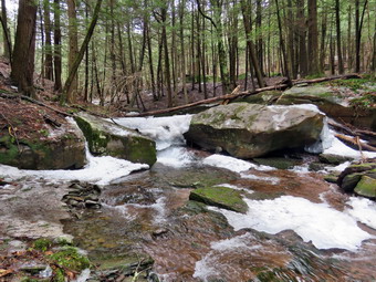
![]()
![]()
![]()
![]()
![]() On Saturday, March 30th I planned to meet my brother-in-law Jeff for a hike. I called him the night before and, after some discussion, we decided to hike at Kelly Hollow. Jeff was not sure of the location so we agreed to meet at the parking area on the south side of the Dunraven Bridge across the Pepacton Reservoir at 10:00 AM. When I got up in the morning it was already in the low 40's and I knew it would grow warmer throughout the day. I asked Cindy if she wanted to hike and she agreed. The hike is only about 4 miles but there are some interesting sites including a stream that runs between the trail out and the trail back. There is also a beaver pond on the trail with a lean-to. We began to get ready ay 9:00 AM preparing to leave just before 9:30 AM. Sheila knew that we were going hiking and kept and eye on us to make sure we would not forget her. I dressed in my long-sleeved Mammut crew top with a long-sleeved baselayer. I knew this might be a little too warm but felt I could always remove a layer if needed. I put on a pair of Columbia Omniheat hiking pants which have a reflective lining. The pants have Velcro closures at the ankles which I hoped would fend off any ticks which might be out in the warmer weather. I donned my Mammut hoody which has enough zippers to dump heat if needed. I put on a light hat and gloves. I put on my Keen Glarus hiking boots which have become my "go to" boots which Keen has discontinued. This last pair is hard to keep waterproof and the sole is delaminating before I would expect. I did put on a pair of OR Crocodile gaiters. We had decided to take our spikes but to forgo the snowshoes. We got Sheila and our gear in the car and I drove downtown to check the mail. We then headed north on State Route 17 toward Roscoe at 9:30 AM. I prefer using the Beaverkill and Barkaboom Roads which saves some miles but Cindy prefers fewer back roads. I took exit 94 and drove north toward the Pepacton Reservoir on Route 206. At the junction with Route 30, I turned right and followed Route 30 to the Dunraven Bridge. We pulled into the parking area at 10:05 AM and waited for Jeff to appear. At 10:15 AM, I decided to cross the bridge and drive toward Route 28 on Route 30. When we arrived at Route 28, Jeff was not there so I turned around and drove back to the bridge. There is no cell phone service in the area so when we did not find Jeff in the working area I turned left on the BWS road. I drove along these roads until reaching the junction with the Barkaboom Road. I turned left on BWS 9. After 4.5 miles, I turned right on Millbrook Road and continued 5.25 miles to the parking lot for Kelly Hollow on the right. We parked at 10:50 AM with one other car in the lot. We had hoped that Jeff might has found his way to the parking area but the car was not his. I took a moment to set my GPS before starting our hike at 10:55 AM by heading out on the trail marked with yellow XC skiing blazes. The temperature was a little above 50 degrees with a slight breeze blowing. The skies were overcast with white clouds but a few blue areas were peeking through. There was some snow in the parking area and a little ice on the trail but it was otherwise clear. My plan was to walk the trail in a figure 8 which is something I had done several times before. We followed the trail as it crossed a small stream and then turned right on the woods road heading south and ascending slightly passing through a gate. Along the way the trail was wet in spots from the rain the night before and there were more icy patches.
On Saturday, March 30th I planned to meet my brother-in-law Jeff for a hike. I called him the night before and, after some discussion, we decided to hike at Kelly Hollow. Jeff was not sure of the location so we agreed to meet at the parking area on the south side of the Dunraven Bridge across the Pepacton Reservoir at 10:00 AM. When I got up in the morning it was already in the low 40's and I knew it would grow warmer throughout the day. I asked Cindy if she wanted to hike and she agreed. The hike is only about 4 miles but there are some interesting sites including a stream that runs between the trail out and the trail back. There is also a beaver pond on the trail with a lean-to. We began to get ready ay 9:00 AM preparing to leave just before 9:30 AM. Sheila knew that we were going hiking and kept and eye on us to make sure we would not forget her. I dressed in my long-sleeved Mammut crew top with a long-sleeved baselayer. I knew this might be a little too warm but felt I could always remove a layer if needed. I put on a pair of Columbia Omniheat hiking pants which have a reflective lining. The pants have Velcro closures at the ankles which I hoped would fend off any ticks which might be out in the warmer weather. I donned my Mammut hoody which has enough zippers to dump heat if needed. I put on a light hat and gloves. I put on my Keen Glarus hiking boots which have become my "go to" boots which Keen has discontinued. This last pair is hard to keep waterproof and the sole is delaminating before I would expect. I did put on a pair of OR Crocodile gaiters. We had decided to take our spikes but to forgo the snowshoes. We got Sheila and our gear in the car and I drove downtown to check the mail. We then headed north on State Route 17 toward Roscoe at 9:30 AM. I prefer using the Beaverkill and Barkaboom Roads which saves some miles but Cindy prefers fewer back roads. I took exit 94 and drove north toward the Pepacton Reservoir on Route 206. At the junction with Route 30, I turned right and followed Route 30 to the Dunraven Bridge. We pulled into the parking area at 10:05 AM and waited for Jeff to appear. At 10:15 AM, I decided to cross the bridge and drive toward Route 28 on Route 30. When we arrived at Route 28, Jeff was not there so I turned around and drove back to the bridge. There is no cell phone service in the area so when we did not find Jeff in the working area I turned left on the BWS road. I drove along these roads until reaching the junction with the Barkaboom Road. I turned left on BWS 9. After 4.5 miles, I turned right on Millbrook Road and continued 5.25 miles to the parking lot for Kelly Hollow on the right. We parked at 10:50 AM with one other car in the lot. We had hoped that Jeff might has found his way to the parking area but the car was not his. I took a moment to set my GPS before starting our hike at 10:55 AM by heading out on the trail marked with yellow XC skiing blazes. The temperature was a little above 50 degrees with a slight breeze blowing. The skies were overcast with white clouds but a few blue areas were peeking through. There was some snow in the parking area and a little ice on the trail but it was otherwise clear. My plan was to walk the trail in a figure 8 which is something I had done several times before. We followed the trail as it crossed a small stream and then turned right on the woods road heading south and ascending slightly passing through a gate. Along the way the trail was wet in spots from the rain the night before and there were more icy patches.
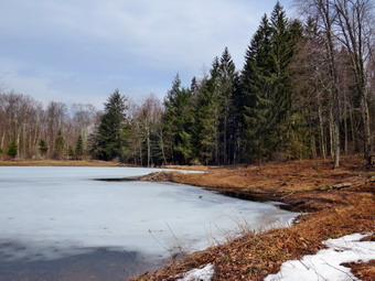 At .3 miles we came to the short spur trail to a designated campsite and passed by as there is not much to see. There was a lot of water flowing in the stream and we could hear and see it easily from above on the bank. At .6 miles we came to the cutoff to the right for the Short Loop hike. We turned right to walk down the cutoff trail to the bridge. The small waterfall below the bridge looked quite inviting so I decided to work my way down the bank to get a better vantage point. As I worked my way down the bank, I realized that the bank was frozen solid and in many places it was simply a thin layer of pine needles over ice. I finally got to a good viewpoint and took off my pack to get out my camera. I took quite a few pictures of the walls and the stream. I packed up and tried to find a good way back ho the bank. I ended up working my way along the stream and climbed the bank, with some problems. Near the bridge. The approach to the bridge was very icy but we worked our way across. I stopped on the bridge to take some pictures and then we continued along the trail. We came to another spot where I wanted to take a side trip down Ti the stream. Sheila alerted and I could see a dog coming toward us with no owner in sight. I put Sheila on her leash as the owner finally came into view. He called his dog to no avail although his dog seemed more interested in hiking. We exchanged grief greetings. This is just one of the many examples of a responsible dog owner meeting one who is either oblivious or irresponsible! I walked down to the stream to another waterfall and was able to get some pictures from the bank. Under better conditions, I would have continued to work my way down to the streambed to unobstructed pictures. I finished and walked back up to the trail. We crossed a bridge across the stream which had an icy approach. We walked up the hill and turned left on the loop trail heading southwest and then south toward the beaver pond and lean-to. Over the next .4 miles we gained almost 300 feet for a 12% grade. Although this is not a steep climb it was more than I remembered. At 1.3 miles we were at the beaver pond which is quickly becoming a beaver meadow. On this day there was quite a bit of water and some ice. Sheila decided to walk out on the ice which we did not appreciate! There are no more beavers in the area but there is a small lodge on the shore. There were some nice patches of blue in a sky full of puffy white clouds so I took some pictures before we continued around the pond. The grass and briars were still prominent on the trail. We crossed a small stream on a bridge and stopped again on the other side. I took a few more pictures before continuing on to the lean-to in the woods. The lean-to was in good shape but beginning to deteriorate so we passed by without stopping.
 We continued on the trail now heading northeast and downhill. The trail made a turn so that we were heading southeast and we crossed a few bridges over small streams. There were several blowdowns to work around or over. This side of the trail had more ice and we considered putting on our spikes several times. At one point we started to walk through a grove of pines and I stopped to take a few shots. At 2 miles we came to the spot where I had bushwhacked up to Millbrook Ridge to look down on Alder Lake. At 2.3 miles we made an almost 180 degree turn and started heading north. I noted that this would be a good place to try another bushwhack as it was only .7 miles to the trail that runs along Millbrook Ridge. We continued north on the trail still descending. We were headed toward the crossover trail which we would again use to finish or figure 8. We came across a point where a larger waterfall was almost visible from the trail. The bank was too steep to descend so I took pictures as I could from the bank. Sheila alerted as we walked and we could see a couple approaching us. I again leashed Sheila and the couple passed by with a few welcoming words. We walked a little farther and I found a way to walk down the bank to a point I could get a better view. I though about descending down to the streambed. I realized I could slide down the bank but I could not slide up the bank. I decided to stay where I was an take some pictures. This is definitely is a spot I will return to under better conditions. At 3 miles we again came to the crossover trail and turned left to cross the middle of the figure 8. We again carefully crossed the bridge and walked up the hill on the other side to the main trail. This time we turned right and started to walk 1.1 miles back to the car. The day was pleasant with a slight breeze blowing and I had long ago removed my hat and gloves and had opened the zippers on my hoody. This part of the trail was not well marked but the path was pretty obvious as it followed a woods road. Along the way another substantial waterfall appeared and I just had to walk down the bank to get a better view. I took some shots and then returned to the trail. This part of the trail was very wet with a few patches of ice. At 3.9 miles we finished the descent and came to the Middletown Cemetery. We continued out the access road to Millbrook Road avoiding a great amount of mud on the access road. We turned right and walked the final .3 miles back to the car. It was 2:05 PM and we had spent 3 hours and 15 minutes hiking 4.5 miles with an elevation gain of 735 feet. We had paused for a little over 40 minutes most of which was for my streams exploration and photography breaks. The temperature when we returned to the car was 52 degrees.
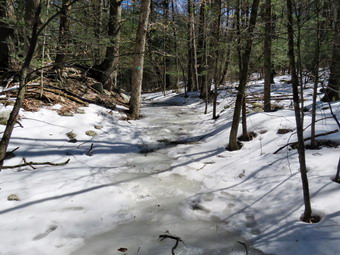
![]()
![]()
![]()
![]()
![]() On Saturday, March 13rd, I couldn't decide whether or not I was ready to hike again after having been out the day before. I finally decided that I would feel better going for a walk and chose to head back to Sam's Point. My plan was to hike the South Gully Trail from Route 52 to the Loop Road and Sam's Point. I remembered this a s a pleasant, rather flat hike along a stream with several small waterfalls. I didn't know whether I would find much snow but did think there might be some ice based on the conditions we had found at Sam's Point the week before. I did not bother to ask Cindy if she wanted to hike as I did not want to hear her say "No". I am always glad that I have Sheila because she always answers "Yes"! Since I have been teaching again full time, I have not had as much time to hike with Sheila so she kept her eye on me as I began to get ready. The temperature as I was getting ready at 11:15 AM the temperature was still in the mid 30's with a stiff wind blowing. I put on a long-sleeved base layer and wore my Mammut pullover which is heavier than most others I own. I put on a pair of tights underneath my Columbia Omniheat hiking pants which have a reflective lining. The pants have Velcro closures at the ankles which means gaiters are not usually needed until the snow gets deeper. I donned my Mammut hoody which has enough zippers to dump heat if needed. I put on a hat and gloves. I wore my Solomon B-52 winter hiking boots as I did not know how much snow and ice to expect. I also put on a pair of OR Crocodile gaiters to fend off the ticks which I thought might be out. I grabbed a pair of Leki poles with external locks that I have been using lately. I brought my spikes just in case I ran into more ice than I had anticipated. I also brought along my Tubbs Alp Flex VTR snowshoes with the Boa binding. This binding uses a thin steel cable system and a ratchet which tightens it to give a custom fit and a secure binding. These snowshoes also have a televator to elevate the hiker's heel on ascents. This is a feature that you didn't know you needed until you try it and then it is hard to live without it! I got my gear in my car and put Sheila in the backseat before heading out the driveway. I stopped to check the mail and then I headed south and east on the Quickway to Liberty a little after 11:30 AM. I took Route 52 toward Woodbourne and Ellenville. In Ellenville I continued on Route 52 up the mountain toward Cragsmoor. Just after crossing South Gully on the road bridge, I turned around and parked on the east side of the road where the trail crosses. The temperature was just 40 degrees and there was no new snow at all! I knew I would not need the snowshoes. The air temperature felt warm but the wind seemed to cut through even my wind-resistant jacket. I set my GPS unit and we started out on the trail at 12:10 PM. We passed a sign that explained the importance of limiting the spread of invasive species and A sign that, incorrectly, gave the distances to South Gully Road and the Loop Road at Sam's Point. Shortly after starting on the trail, we approached a pile of branches on the trail. As I worked my way around these branches, the wind came up and a large branch fell beside me on the trail. I thought that it would have done some mage had it hit me but continued anyway.
On Saturday, March 13rd, I couldn't decide whether or not I was ready to hike again after having been out the day before. I finally decided that I would feel better going for a walk and chose to head back to Sam's Point. My plan was to hike the South Gully Trail from Route 52 to the Loop Road and Sam's Point. I remembered this a s a pleasant, rather flat hike along a stream with several small waterfalls. I didn't know whether I would find much snow but did think there might be some ice based on the conditions we had found at Sam's Point the week before. I did not bother to ask Cindy if she wanted to hike as I did not want to hear her say "No". I am always glad that I have Sheila because she always answers "Yes"! Since I have been teaching again full time, I have not had as much time to hike with Sheila so she kept her eye on me as I began to get ready. The temperature as I was getting ready at 11:15 AM the temperature was still in the mid 30's with a stiff wind blowing. I put on a long-sleeved base layer and wore my Mammut pullover which is heavier than most others I own. I put on a pair of tights underneath my Columbia Omniheat hiking pants which have a reflective lining. The pants have Velcro closures at the ankles which means gaiters are not usually needed until the snow gets deeper. I donned my Mammut hoody which has enough zippers to dump heat if needed. I put on a hat and gloves. I wore my Solomon B-52 winter hiking boots as I did not know how much snow and ice to expect. I also put on a pair of OR Crocodile gaiters to fend off the ticks which I thought might be out. I grabbed a pair of Leki poles with external locks that I have been using lately. I brought my spikes just in case I ran into more ice than I had anticipated. I also brought along my Tubbs Alp Flex VTR snowshoes with the Boa binding. This binding uses a thin steel cable system and a ratchet which tightens it to give a custom fit and a secure binding. These snowshoes also have a televator to elevate the hiker's heel on ascents. This is a feature that you didn't know you needed until you try it and then it is hard to live without it! I got my gear in my car and put Sheila in the backseat before heading out the driveway. I stopped to check the mail and then I headed south and east on the Quickway to Liberty a little after 11:30 AM. I took Route 52 toward Woodbourne and Ellenville. In Ellenville I continued on Route 52 up the mountain toward Cragsmoor. Just after crossing South Gully on the road bridge, I turned around and parked on the east side of the road where the trail crosses. The temperature was just 40 degrees and there was no new snow at all! I knew I would not need the snowshoes. The air temperature felt warm but the wind seemed to cut through even my wind-resistant jacket. I set my GPS unit and we started out on the trail at 12:10 PM. We passed a sign that explained the importance of limiting the spread of invasive species and A sign that, incorrectly, gave the distances to South Gully Road and the Loop Road at Sam's Point. Shortly after starting on the trail, we approached a pile of branches on the trail. As I worked my way around these branches, the wind came up and a large branch fell beside me on the trail. I thought that it would have done some mage had it hit me but continued anyway.
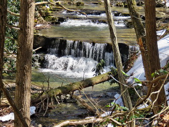 I stopped to take a few shots of the trail which had patches of ice but not much snow. I also took some pictures of the stream below. My memory had betrayed me as we soon began to climb veering away from the stream. Over the next .7 miles we gained over 500 feet over a 15% grade. The trail was muddy in places but mostly alternated from clear to areas of ice. These alternating patches made it hard to put on spikes as they would soon be useless. There were many blowdowns and, in places, the trail was poorly marked. My impression was that some real work needs to be done to get this trail back in shape! At about 1 mile the trail began to descend back toward the stream. The trail was a sheet of ice and I stopped to put on my spikes. As I sat on a bank next to the trail, I had to find a way to prop myself up as even the frozen ground was slippery. I managed to get my spikes on and walk gingerly down the trail to an area covered in hard-crusted snow. I walked over to the stream and got a few pictures of some small waterfalls. There were none of the larger falls I remembered but I did notice that there was quite a bit of erosion along the stream. I walked back to the trail and started an ascent over a river of ice. There was no way to walk around this ice so I carefully worked my way to the top where it thinned out. Sheila, who has built-in crampons, seemed to have no trouble at all. Continuing along the trail we again ran into patches of clear trail alternating with ice. We also had to cross several small streams which was actually easier than I thought it would be. We again ran into a descent where I put my spikes on again and crossed a stream which was deeper and faster flowing than the others. After crossing the stream, I tried to follow the aqua blazes of the Long Path but could not find them along the path that seemed to be favored by previous hikers. Even Sheila was having trouble finding the trail. I returned to the area near the stream and looked ahead for the blazes. I was lucky enough to look to my left and see the blazes farther up the hill. There was no marking for a turn and this area certainly needs some attention. We walked up the hill parallel to the gully made by the stream. I knew we were nearing South Gully Road and I could soon see the pavement. At this point the wind began to blow again and another branch fell next to the trail! At 2:10 PM we arrived at South Gully Road after hiking 2.15 miles and gaining over 800 feet. The distance was almost half a mile farther than marked on the sign at the beginning of the trail. I was not having much fun, it was growing late and I was not looking forward to returning the way I had come. I decided we would walk back to the car on the roads.
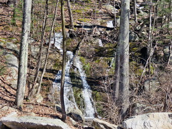 I was actually excited to walk back on the roads as I knew we could make good time and it was a route I had never tried before. Walking roads on hikes is nothing new to us as we have done it often hiking the Long Path and the Finger lakes Trail. What I could not properly gauge is how long the road walk would be. I stowed my poles in my packs and put Sheila on her leash. We turned left and started northwest on the road. It was a pleasure to be walking downhill with good footing. I was surprised that quite a few cars passed us on the road ting in both directions. Sheila walks very nicely on her leash and I could soon see Route 52. At 3.65 miles the road turned north and began to head north which lengthened the distance back to the car. This last stretch of road down to Route 52 was a steep descent. We stopped along the way so that I could take pictures of a waterfall on the right side of the road. After getting a drink, we continued down to Route 52 where we turned left and started up hill. I took a quick look at my GPS and found it was less than a mile back to the car. We walked along the wide shoulder of the road avoiding the broken glass that always seems to be present. We stopped briefly so that I could look down from the bridge to the stream far below. I noticed that the temperature seemed to be much warmer as we arrived back at the car at 3:10 PM. We had hiked 5.4 miles in 3 hours gaining a total of 1215 feet. It had taken us 2 hours to fight up the 2.15 miles up the icy trail and only 1 hour to walk the other 3.2 miles back to the car! I thought about stopping to take some pictures from farther up the mountain. I also thought about stopping to take pictures of the waterfall that is on Route 52 in the village of Ellenville. In both cases, I decided I was just too tried and drove directly home.
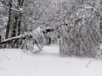
![]()
![]()
![]()
![]()
![]() On Saturday, March 22nd, I had wanted to get out on a hike after a snowfall the night before. It was ironic that we had a scheduled day off from school as a "give back" day because we had used so few snow days. All of the other schools in Sullivan County closed! I was supplied to hear from a few friends that up to 8 inches of snow had fallen at only slightly higher elevations around the valley. I knew that the Frick Pound area might have more snow that around Livingston Manor and decided to take try snowshoeing there. I asked Cindy if she wanted to go and got a sort of noncommittal response. I began to get ready but delayed a little to let the road crews plow. When I started to put my gear together at 10:30 AM, Cindy told me she wasn't going. I was disappointed as we had been hiking together over the last few weeks. I knew that hiking in difficult conditions with snowshoes is easier when you have a human companion. I knew that once Cindy said "no" there was no use trying to convince her so I continued to prepare. I can always count on Sheila as she is always ready to go and this day was no exception. The temperature in town was 37 degrees but I knew it might be a few degrees colder at Frick Pond. I put on a long-sleeved base layer and wore my Mammut pullover which is heavier than most others I own. I put on a pair of tights underneath my Columbia Omniheat hiking pants. These have a reflective lining and are heavier than my "go to" Railriders pants. The pants have Velcro closures at the ankles which means gaiters are not usually needed until the snow gets deeper. I donned my Mammut hoody which has enough zippers to dump heat if needed. I put on a heavier hat and gloves. I wore my Salomon B52 winter boots which are all leather and seem to be waterproof with sufficient insulation. I decided to put on a pair of OR Crocodile gaiters. I grabbed a pair of Leki poles with external locks that I have been using lately. I decided to wear my Tubbs Alp Flex VTR snowshoes with the Boa binding. This binding uses a thin steel cable system and a ratchet which tightens it to give a custom fit and a secure binding. These snowshoes also have a televator to elevate the hiker's heel on ascents. This is a feature that you didn't know you needed until you try it and then it is hard to live without it! I made sure my microspikes were in my pack as I was not sure whether I would use the snowshoes of the spikes. At 10:45 AM we walked out the door, got in the car and went to the post office to check the mail. I started out DeBruce Road toward Frick Pond and after 6 miles, at Mongaup Pond Road, I turned left and continued to follow the road bearing left onto Beech Mountain Road at the fork. The road was not plowed which surprised me a little. When we arrived in the parking area, there were no cars in the parking lots and neither of the lots was plowed. I parked in the smaller lot as I planned to start at the beginning of the Flynn Trail. The temperature was 34 degrees and a sustained wind was blowing and then gusting. The wind was causing snow and slush to fall from the trees which was unpleasant. I got out of the car and found there was at least six inches of new snow and I knew this could increase as we gained elevation. I was unhappy hat the show was heavy and I knew this would mean it would clump on the snowshoes. I decided to put on the snowshoes as the Flynn Trail looked untouched. I finished getting ready by setting my GPS unit. We crossed the road and started our hike on the Flynn Trail at 11:15 AM. The trail was unbroken but there wasn't too much snow in the areas covered by the trees. At the end of the trail through the woods we turned right on the old Beech Mountain Road and continued to follow the Flynn trail uphill. The snow immediately became deeper where the trail was exposed.
On Saturday, March 22nd, I had wanted to get out on a hike after a snowfall the night before. It was ironic that we had a scheduled day off from school as a "give back" day because we had used so few snow days. All of the other schools in Sullivan County closed! I was supplied to hear from a few friends that up to 8 inches of snow had fallen at only slightly higher elevations around the valley. I knew that the Frick Pound area might have more snow that around Livingston Manor and decided to take try snowshoeing there. I asked Cindy if she wanted to go and got a sort of noncommittal response. I began to get ready but delayed a little to let the road crews plow. When I started to put my gear together at 10:30 AM, Cindy told me she wasn't going. I was disappointed as we had been hiking together over the last few weeks. I knew that hiking in difficult conditions with snowshoes is easier when you have a human companion. I knew that once Cindy said "no" there was no use trying to convince her so I continued to prepare. I can always count on Sheila as she is always ready to go and this day was no exception. The temperature in town was 37 degrees but I knew it might be a few degrees colder at Frick Pond. I put on a long-sleeved base layer and wore my Mammut pullover which is heavier than most others I own. I put on a pair of tights underneath my Columbia Omniheat hiking pants. These have a reflective lining and are heavier than my "go to" Railriders pants. The pants have Velcro closures at the ankles which means gaiters are not usually needed until the snow gets deeper. I donned my Mammut hoody which has enough zippers to dump heat if needed. I put on a heavier hat and gloves. I wore my Salomon B52 winter boots which are all leather and seem to be waterproof with sufficient insulation. I decided to put on a pair of OR Crocodile gaiters. I grabbed a pair of Leki poles with external locks that I have been using lately. I decided to wear my Tubbs Alp Flex VTR snowshoes with the Boa binding. This binding uses a thin steel cable system and a ratchet which tightens it to give a custom fit and a secure binding. These snowshoes also have a televator to elevate the hiker's heel on ascents. This is a feature that you didn't know you needed until you try it and then it is hard to live without it! I made sure my microspikes were in my pack as I was not sure whether I would use the snowshoes of the spikes. At 10:45 AM we walked out the door, got in the car and went to the post office to check the mail. I started out DeBruce Road toward Frick Pond and after 6 miles, at Mongaup Pond Road, I turned left and continued to follow the road bearing left onto Beech Mountain Road at the fork. The road was not plowed which surprised me a little. When we arrived in the parking area, there were no cars in the parking lots and neither of the lots was plowed. I parked in the smaller lot as I planned to start at the beginning of the Flynn Trail. The temperature was 34 degrees and a sustained wind was blowing and then gusting. The wind was causing snow and slush to fall from the trees which was unpleasant. I got out of the car and found there was at least six inches of new snow and I knew this could increase as we gained elevation. I was unhappy hat the show was heavy and I knew this would mean it would clump on the snowshoes. I decided to put on the snowshoes as the Flynn Trail looked untouched. I finished getting ready by setting my GPS unit. We crossed the road and started our hike on the Flynn Trail at 11:15 AM. The trail was unbroken but there wasn't too much snow in the areas covered by the trees. At the end of the trail through the woods we turned right on the old Beech Mountain Road and continued to follow the Flynn trail uphill. The snow immediately became deeper where the trail was exposed.
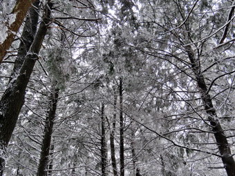 Sheila started up the trail breaking a little track for me to follow. When she began to follow animal tracks, I directed her to stay in the middle of the woods road. I am no longer surprised when Sheila does exactly what I ask her as she is a great trail dog. When we came to the tunnel that I had cut in a big spruce tree that had fallen across the trail, we stopped so that I could take some pictures of that tree and the snow on the trail. The walking was tiring and it wasn't the kind of snow where Sheila could break much of a trail. We stopped every now and then so that I could catch my breath. On one stop I opened the zippers on my hoody. I was getting warm working on the ascent despite the wind. I missed talking to Cindy but that might have been hard since the wind continued to blow. I stopped again to take some pictures of the unbroken snow and the snow still clinging to the trees. It took almost an hour to hike a little over one mile to the area where there is a clearing on the eastern side of the trail. I was tired and knew there was still more than half a mile to the Big Rock Trail. My plan had been to hike to the trail junction and then to the lookout over Hodge Pond on Beech Mountain coming back to the Big Rock Trail and down to Times Square. I now knew that I would not be hiking to Hodge Pond. I knew that the Big Rock Trail would not be packed by snowmobiles and that I would have to break the trail all the way. It seemed like a long haul to the junction with the Big Rock Trail. After 1.7 miles of uphill hiking, we reached the Big Rock Trail after almost and hour and 15 minutes of walking. The trail was unbroken but at least I knew that most of the rest of the trip was downhill or flat! We turned left and started downhill on the heavy, freshly fallen snow which was a real pleasure! Sheila seemed to agree as she ran ahead and then doubled back at a furious pace despite sinking into deep snow. At the junction of the two trails there was at least 9 inches of freshly fallen snow with a few inches of base beneath. We made good time heading for Times Square. There are three separate areas where the trail levels and then descends and again but I was ready for these. On the way down the snow grew less but was sticking to my snowshoes. I kept stopping to knock the snow off which slowed the descent.
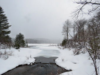 When we reached Times Square, we continued straight ahead on the Big Rock Trail around the back of Frick Pond keeping a fast pace. We cross both of the bridges over the small inlet streams to Frick Pond. We stopped in the woods and I took a few pictures of the trail through the spruce forest. We walked across the wooden causeways which were covered in snow. I had thought I would take some pictures but I was tired and there was nothing exceptional. We continued over the rest of the Big Rock Trail out to the Quick Lake Trail. We turned left on the Quick Lake Trail which also was covered in freshly-fallen snow. It was a short walk to the bridge across the outlet of Frick Pond. As we approached, the wind began blowing in earnest and more snow was falling. Even though I have taken many pictures from the bridge and the visibility was poor, I couldn't resist stopping to take a few more. I took shots of the pond and Beech Mountain, hidden in the snow. I packed up and we headed up the hill. We passed through Gravestone Junction and continued on the woods road back toward the parking area. This trail is usually wet but there were only a few spots of open of water with the rest frozen solid. As we approached the register box, I decided to continue straight ahead on the woods road that leads directly to the parking area. The walk was short and we emerged in the small parking area where there were two cars now parked. The other lot was still not plowed! We walked over to the car after hiking 4 miles in 2 hours and 40 minutes with a vertical gain of 720 feet. The temperature was 34 degrees, the same as the beginning of the hike.