| Pick a Catskill 35 Peak: |
Balsam Lake Mountain
Balsam Lake Mountain can be accessed from the Beaverkill Road, the Millbrook-Arena Road or from the Millbrook Ridge Trail from Alder Lake. The mountain has one of five reconstructed and maintained fire towers in the Catskill Park. The mountain can be hiked as an out-and-back or as a loop. Any of the loops can be done in either direction.
Attention: As of January 13, 2021 Doubletop and Graham Mountains have been closed to all hikers. The mountains are on private property owned by the Gould family who for years have allowed hikers free access. The family has decided to exercise their private property right and anyone found on their property will be trespassing. The descriptions on this page remain as they are a part of the history of hiking in the Catskills.
| Trailhead Coordinates | |
|---|---|
| Name | Coordinates |
| Beaverkill Road (end) | N42.0239 W74.5998 |
| Millbrook Road | N42.0704 W74.5738 |
| Alder Lake | N42.0499 W74.6827 |
| Quick Look - Balsam Lake Loop from Beaverkill | ||||
|---|---|---|---|---|
| Difficulty | Round trip | Total climb | Location | Internet Maps |
| 4.3 mi. | 1210 ft. | N42.0458 W74.5944 | AllTrails | |
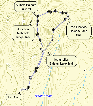
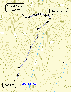
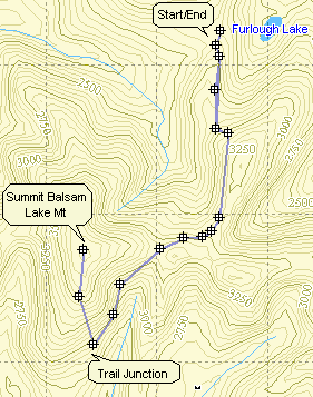
From the intersection of Old Route 17 and DeBruce Road in Livingston Manor, drive 1.3 miles north to Beaverkill Road. Turn right on Beaverkill Road and drive 20 miles to the end of the Beaverkill Road passing through Lew Beach and Turnwood. Park at the trailhead at the end of the Beaverkill Road. The public road dead ends at this spot and a private road on the left continues to the Balsam Lake Lodge. Find the blue-blazed Dry Brook Ridge Trail and hike .9 miles to the junction with the red blazed Balsam Lake Mountain Trail on the left. Turn left at this junction and begin an ascent of .85 miles gaining 825 feet. The grade is tee and in places is 28%. There is a spring just after the 3500 foot marker and just below the spring a side trail on the left leads to a lean-to. At 1.5 miles the Millbrook Ridge Trail branches off to the left leading across Millbrook Ridge to Alder Lake. At 1.7 miles you will break out into the summit clearing and see your reward for the steep hike. There is no view from the ground but the mountain has one of the five fire towers remaining in the Catskill Park. The fire tower offers a spectacular view in all directions. Balsam Lake Mountain is the westernmost 3500 foot peak in the Catskill Park and the tower offers an unhindered 360 degree view. When you are finished taking in the view, continue on the red trail as it heads east from the summit. The trail descends for .75 miles losing 415 feet until it rejoins the Dry Brook Ridge Trail. Turn right here and hike 1.9 miles back to the trailhead.
| Quick Look - Balsam Lake Out and Back from Beaverkill (steep) | ||||
|---|---|---|---|---|
| Difficulty | Round trip | Total climb | Location | Internet Maps |
| 3.3 mi. | 1171 ft. | N42 02.73 W74 53.70 | AllTrails | |
From the intersection of Old Route 17 and DeBruce Road in Livingston Manor, drive 1.3 miles north to Beaverkill Road. Turn right on Beaverkill Road and drive 20 miles to the end of the Beaverkill Road passing through Lew Beach and Turnwood. Park at the trailhead at the end of the Beaverkill Road. The public road dead ends at this spot and a private road on the left continues to the Balsam Lake Lodge. Find the blue-blazed Dry Brook Ridge Trail and hike .9 miles to the junction with the red blazed Balsam Lake Mountain Trail on the left. Turn left at this junction and begin an ascent of .85 miles gaining 825 feet. The grade is tee and in places is 28%. There is a spring just after the 3500 foot marker and just below the spring a side trail on the left leads to a lean-to. At 1.5 miles the Millbrook Ridge Trail branches off to the left leading across Millbrook Ridge to Alder Lake. At 1.7 miles you will break out into the summit clearing and see your reward for the steep hike. There is no view from the ground but the mountain has one of the five fire towers remaining in the Catskill Park. The fire tower offers a spectacular view in all directions. Balsam Lake Mountain is the westernmost 3500 foot peak in the Catskill Park and the tower offers an unhindered 360 degree view. When you are done, return the way you came making your way back down the steep ascent. When you reach the Dry Brook Ridge trail at the bottom turn right and hike .9 miles back to your car.

| Quick Look - Balsam Lake Out and Back from Beaverkill (gentle) | ||||
|---|---|---|---|---|
| Difficulty | Round trip | Total climb | Location | Internet Maps |
| 4.5 mi. | 1142 ft. | N42 02.73 W74 53.70 | AllTrails | |
From the intersection of Old Route 17 and DeBruce Road in Livingston Manor, drive 1.3 miles north to Beaverkill Road. Turn right on Beaverkill Road and drive 20 miles to the end of the Beaverkill Road passing through Lew Beach and Turnwood. Park at the trailhead at the end of the Beaverkill Road. The public road dead ends at this spot and a private road on the left continues to the Balsam Lake Lodge. Find the blue-blazed Dry Brook Ridge Trail and hike .9 miles to the first trail junction. Continue straight ahead on the blue-blazed trail to 1.9 miles to a second junction with the Balsam Lake Mountain Trail. Turn left and begin the ascent to the summit. The trail gains 415 ft. in .7 miles with several steep sections alternating with flatter areas. The reward for the climb is the fire tower at the summit of the mountain. There is no view from the ground but the views from the tower take in most of the 3500 foot peaks. To return to the parking area retrace your route back down the mountain to the Dry Brook Ridge Trail. Turn right and hike 1.9 miles back to the parking area.

| Quick Look - Balsam Lake Loop from Millbrook | ||||
|---|---|---|---|---|
| Difficulty | Round trip | Total climb | Location | Internet Maps |
| 6.7 mi. | 1675 ft. | N42 02.73 W74 53.70 | AllTrails | |
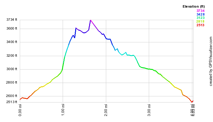
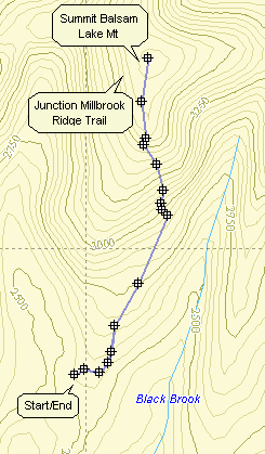
From the bridge in Margaretville drive east on Route 28 for 1.1 miles to Dry Brook Road in Arkville. Turn right and drive 6 miles to Millbrook Road. Turn right and drive about 2.2 miles to the parking area on the right. From the intersection of Rt 7 and Rt 30 east of Downsville drive 11.7 mile east on Route 30 along the Pepacton Reservoir to the Dunraven Bridge. Turn right on BWS 8 and drive 1.9 miles. Turn left on BWS 9 and drive 4.6 miles to Millbrook Road. Turn right and drive 9.8 miles to the parking area on the left. Cross Millbrook Road and begin your hike on the blue Dry Brook Ridge Trail. Much of the trail is on an old woods road which is still passable by four wheel drive vehicle. Hike 2.1 miles to the junction with the red Balsam Lake Mountain Trail. Turn right and begin the ascent to the summit. The trail gains 415 ft. in .7 miles with several steep sections alternating with flatter areas. The reward for the climb is the fire tower at the summit of the mountain. There is no view from the ground but the views from the tower take in most of the 3500 foot peaks. To return to the parking area continue on the red trail as it exits the summit to the south. The first part of this trail is a gentle descent which becomes steeper as it starts down a set of stone steps near a spring. The steps are often damp and slippery. Along the way the Millbrook Ridge Trail to Alder lake branches to the right at 3.0 miles. A spur trail to the right just below the spring leads to a lean-to. The trail from the summit to the junction with the blue Dry Brook Ridge Trail is only .8 miles but the loss in elevation is 830 feet. Parts of the trail average a 28% grade. At the junction with the red Dry Brook Ridge Trail turn left and hike 3.1 miles back to the parking area.
| Quick Look - Balsam Lake Out and Back from Millbrook (gentle) | ||||
|---|---|---|---|---|
| Difficulty | Round trip | Total climb | Location | Internet Maps |
| 6.0 mi. | 1260 ft. | N42 02.73 W74 53.70 | AllTrails | |
From the bridge in Margaretville drive east on Route 28 for 1.1 miles to Dry Brook Road in Arkville. Turn right and drive 6 miles to Millbrook Road. Turn right and drive about 2.2 miles to the parking area on the right. From the intersection of Rt 7 and Rt 30 east of Downsville drive 11.7 mile east on Route 30 along the Pepacton Reservoir to the Dunraven Bridge. Turn right on BWS 8 and drive 1.9 miles. Turn left on BWS 9 and drive 4.6 miles to Millbrook Road. Turn right and drive 9.8 miles to the parking area on the left. Cross Millbrook Road and begin your hike on the blue Dry Brook Ridge Trail. Much of the trail is on an old woods road which is still passable by four wheel drive vehicle. Hike 2.1 miles to the junction with the red Balsam Lake Mountain Trail. Turn right and begin the ascent to the summit. The trail gains 415 ft. in .7 miles with several steep sections alternating with flatter areas. The reward for the climb is the fire tower at the summit of the mountain. There is no view from the ground but the views from the tower take in most of the 3500 foot peaks. To return to the parking area retrace your steps by hiking back down the trail to the Dry Brook Ridge Trail. Turn left and hike 2.1 miles back to the parking area.

| Quick Look - Balsam Lake Out and Back from Millbrook (steep) | ||||
|---|---|---|---|---|
| Difficulty | Round trip | Total climb | Location | Internet Maps |
| 7.5 mi. | 2107 ft. | N42 02.73 W74 53.70 | AllTrails | |
From the bridge in Margaretville drive east on Route 28 for 1.1 miles to Dry Brook Road in Arkville. Turn right and drive 6 miles to Millbrook Road. Turn right and drive about 2.2 miles to the parking area on the right. From the intersection of Rt 7 and Rt 30 east of Downsville drive 11.7 mile east on Route 30 along the Pepacton Reservoir to the Dunraven Bridge. Turn right on BWS 8 and drive 1.9 miles. Turn left on BWS 9 and drive 4.6 miles to Millbrook Road. Turn right and drive 9.8 miles to the parking area on the left. Cross Millbrook Road and begin your hike on the blue Dry Brook Ridge Trail. Much of the trail is on an old woods road which is still passable by four wheel drive vehicle. Hike 3.1 miles to the second junction with the red Balsam Lake Mountain Trail. Turn right and begin the steep ascent to the summit. The ascent is .85 miles gaining 825 feet making the grade 28% for a long stretch. There is a spring just after the 3500 foot marker and just below the spring a side trail on the left leads to a lean-to. As you hike from the spring to the summit the Millbrook Ridge Trail branches off to the left leading across Millbrook Ridge to Alder Lake. At 3.9 miles you will break out into the summit clearing and see your reward for the steep hike. There is no view from the ground but the mountain has one of the five fire towers remaining in the Catskill Park. The fire tower offers a spectacular view in all directions. Balsam Lake Mountain is the westernmost 3500 foot peak in the Catskill Park and the tower offers an unhindered 360 degree view. When you are done, return the way you came making your way back down the steep ascent. When you reach the Dry Brook Ridge trail at the bottom turn left and hike 3.1 miles back to your car.

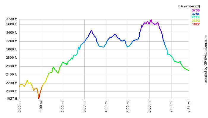
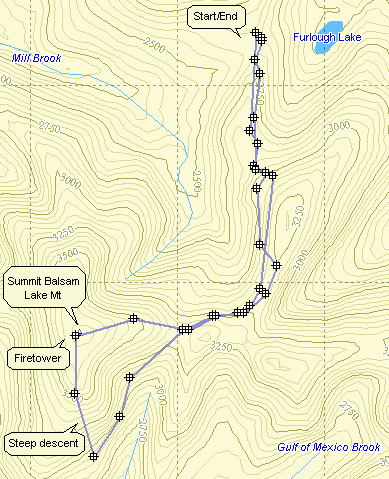
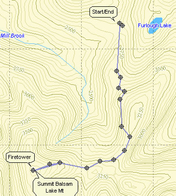
| Quick Look - Alder Lake to Balsam Lake Mountain | ||||
|---|---|---|---|---|
| Difficulty | Round trip | Total climb | Location | Internet Maps |
| 7.8 mi. | 2628 ft. | N42 02.73 W74 53.70 | AllTrails | |
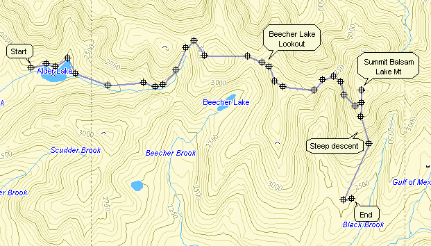
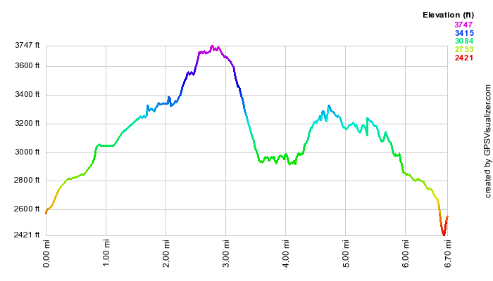
This hike is 7.8 miles one way making a round trip hike 15.6 miles. Road walking does not help as it makes the hike longer. It may be best to arrange for a pickup or to setup a car shuttle.>From the intersection of Old Route 17 and DeBruce Road in Livingston Manor, drive 1.3 miles north to Beaverkill Road. Turn right on Beaverkill Road and drive 20 miles to the end of the Beaverkill Road passing through Lew Beach and Turnwood. Park at the trailhead at the end of the Beaverkill Road. The public road dead ends at this spot and a private road on the left continues to the Balsam Lake Lodge. Park one car in the parking area. Drive back down the Beaverkill Road for 8.0 miles to Alder Creek Road. Turn right on Alder Creek Road and drive 2.2 miles to the end of the road. Bear right sharply onto the access road to Alder Lake and park in the parking lot. Walk out of the end of the parking area toward the lake. The Coykendall mansion house that stood on the grounds has been removed by New York State as they did not have the money to maintain or restore it. Now only the stone work remains. As you walk toward the lake stay left to get on the red Alder Lake Loop Trail. After about .8 miles on this trail the yellow Millbrook Ridge trail turns to the left heading east. The trail ascends very gently and at about 2.2 miles you arrive at the Beaver Meadow lean-to and spring. There once was a large beaver pond here but it is now being reclaimed and forming a meadow. Back on the trail you will pass another pond on your right after which the trail climbs more steeply. At about 3.4 miles you are at the highest point on the ridge (3480 ft) which is a peak on the Catskill Highest Hundred list. The trail then descends slightly before another ascent to the overlook at 4.7 miles into the hike. The viewpoint looks down on Beecher Lake and a Zen Buddhist monastery on its shore. Continue on the main trail heading east and southeast toward Balsam Lake Mountain. At about 5.6 miles you will begin the final climb up to mountain which is on the Catskill 3500 list. The climb is only .3 miles but gains 380 feet making the average grade 22%! At 5.9 miles the Millbrook Ridge Trail ends at the Balsam Lake Mountain Trail. Turn left and walk to the Balsam Lake fire tower at the summit of the mountain which is your reward for the steep hike. There is no view from the ground but the mountain has one of the five fire towers remaining in the Catskill Park. The fire tower offers a spectacular view in all directions. Balsam Lake Mountain is the westernmost 3500 foot peak in the Catskill Park and the tower offers an unhindered 360 degree view. When you have taken pictures of the tower and from the tower head back the way you came on the red Balsam Lake Mountain Trail. This time pass by the Millbrook Ridge Trail and continue down the mountain. The first part of this trail is a gentle descent which becomes steeper as it starts down a set of stone steps near a spring. The steps are often damp and slippery. A spur trail to the right just below the spring leads to a lean-to. The trail from the summit to the junction with the blue Dry Brook Ridge Trail is only .8 miles but the loss in elevation is 830 feet. Parts of the trail average a 28% grade. At the junction with the red Dry Brook Ridge Trail turn right and hike .9 miles to the parking area. Drive back to Alder Lake to retrieve the other car.