
What You Missed
Summer 2025
Summer 2025
![]()
![]()
![]()
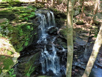
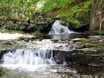
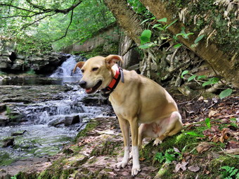
![]() On Friday, September 19th, I planned take Sheena for a longer hike away from Livingston Manor as I had full ambulance coverage from 6:00 AM to 2:00 PM. An early morning ambulance call changed my mind. I finally returned home by 10:00 AM reassured that my cover would respond to the next call. I decided to go to the Parksville Rail Trail as it is close but interesting with a nice falls. I began to get ready at 10:15 AM with bright blue skies and lots of sun. The Parksville Rail Trail is under three miles out and back from Fox Mt Road to Parksville. On this day, I decided to park in Parksville and hike the entire stretch of trail from Parksville to Old Liberty Road which is 6 miles round trip. My intention was to hike as fays as possible without taking pictures. I intended to carry my pack so that I would have my camera if I changed my mind and water and snacks if needed. Sheena actually does get in about twice the mileage that I do as she forges ahead and then comes back to me! I have transitioned from using a leash all the time to using a GarmimSport PRO electronic collar which has many versatile settings and seems to do the job. This allows Sheena to roam and keeps me sane by not having to yank on her leash. It seems that Sheena likes hiking as she smells my clothes and then runs to sit by the door! I got dressed in a new Columbia Omni-Shade Omni-Wick shirt without a baselayer. I put on a pair of RailRiders hiking pants which are expensive but last a long time and have features like deep pockets and a generous cut which I really like. I decided to put on my Keen Durand hiking boots which fit well. I added a new pair of Xstance insoles in an effort to find the best support and cushioning for my feet. These insoles have shock absorbing gel pads, TPU arch support, and memory foam cushioning all wrapped in a breathable fabric. The insoles have been hyped by their manufacturer and seemed to be living up to their claims. I grabbed a pair of Leki Micro Vario poles I have been using for some time because they are light and lock without slipping. I didn't bother to wear my OR floppy hat or gaiters. I put my gear in the back of the car and Sheena in the back seat and we left Livingston Manor at 10:30 AM. I got on Sate Route 17 and headed toward Liberty exiting at exit 98 for Parksville. At the bottom of the ramp I turn left on Short Ave and left again at the next intersection. I parked on the left side of the street where there is room for a few cars. I made sure Sheena's ecollar was adjusted correctly and then I let her out of the car at 10:45 AM. The temperature was 70 degrees and the sun made it feel even warmer.
On Friday, September 19th, I planned take Sheena for a longer hike away from Livingston Manor as I had full ambulance coverage from 6:00 AM to 2:00 PM. An early morning ambulance call changed my mind. I finally returned home by 10:00 AM reassured that my cover would respond to the next call. I decided to go to the Parksville Rail Trail as it is close but interesting with a nice falls. I began to get ready at 10:15 AM with bright blue skies and lots of sun. The Parksville Rail Trail is under three miles out and back from Fox Mt Road to Parksville. On this day, I decided to park in Parksville and hike the entire stretch of trail from Parksville to Old Liberty Road which is 6 miles round trip. My intention was to hike as fays as possible without taking pictures. I intended to carry my pack so that I would have my camera if I changed my mind and water and snacks if needed. Sheena actually does get in about twice the mileage that I do as she forges ahead and then comes back to me! I have transitioned from using a leash all the time to using a GarmimSport PRO electronic collar which has many versatile settings and seems to do the job. This allows Sheena to roam and keeps me sane by not having to yank on her leash. It seems that Sheena likes hiking as she smells my clothes and then runs to sit by the door! I got dressed in a new Columbia Omni-Shade Omni-Wick shirt without a baselayer. I put on a pair of RailRiders hiking pants which are expensive but last a long time and have features like deep pockets and a generous cut which I really like. I decided to put on my Keen Durand hiking boots which fit well. I added a new pair of Xstance insoles in an effort to find the best support and cushioning for my feet. These insoles have shock absorbing gel pads, TPU arch support, and memory foam cushioning all wrapped in a breathable fabric. The insoles have been hyped by their manufacturer and seemed to be living up to their claims. I grabbed a pair of Leki Micro Vario poles I have been using for some time because they are light and lock without slipping. I didn't bother to wear my OR floppy hat or gaiters. I put my gear in the back of the car and Sheena in the back seat and we left Livingston Manor at 10:30 AM. I got on Sate Route 17 and headed toward Liberty exiting at exit 98 for Parksville. At the bottom of the ramp I turn left on Short Ave and left again at the next intersection. I parked on the left side of the street where there is room for a few cars. I made sure Sheena's ecollar was adjusted correctly and then I let her out of the car at 10:45 AM. The temperature was 70 degrees and the sun made it feel even warmer.
The first part of the trail was barely damp as the sun had evaporated any water and there had been no rain. We came to the small garden and plaque on the left side of the trail. The plaque details a short history of Parksville and the O&W railroad. This information includes the importance of the dairy industry and the many hotels that dotted the area. We immediately encountered loud nsuic and barking dogs at the house on the right of the trail. The owner always yells at the dogs that pay absolutely no attention to him!Once we got passed the noise, I noticed that there was relative quiet and that the are was warn with a slight breeze blowing. Off her leash Sheena would run ahead of me a certain distance and then maintain that distance by waiting for me or increasing her pace. The trail was dry and all the soft and muddy patches were gone. The trail runs parallel to the Little Beaverkill and the new section of State Route 17. It follows the route of the O&W railroad and is very flat. Sheena was setting a quick pace and I didn't mind as long as she would listen and wait for me when necessary. The water level in the stream was very low. In a short time we arrived at the rapids and falls. They are making some noise but the water level was low. Many leaves were falling and they poked pretty on the trail and on the area around the falls. I had many pictures of the falls and could wait until there was a little more color on the leaves. We continued our accelerated pace heading for the Fox Mt Road parking area. We came to the area of the landslide and this area was wet and muddy. Sheena pushed on through and I did likewise. We came to the bridge and walkways which were dry so there was no chance of slipping. We came off the wooden walkways and continued on as quickly as possible. We soon popped out of the trees onto the gravel path that leads to the parking area. It was 11:10 AM and we had walked 1.4 miles in 25 minutes!
We walked through the parking area and turned left on Service Road toward Fox Mountain Road. We again turned left to walk underneath the Quickway. We walked to the intersection of Fox Mounatin Road and Benton Hollow Road and hopped the guard rail where I took Sheena off her leash. We immediately came to what was left of the trestle supports that carried the trail tracks over the stream. I noticed what remained of a painting on the trestle. I had seen this painting before but had not realized it was a memorial to NASCAR driver Davey Allison #28 who drove the Texaco-Havoline Ford car. Allison died in a helicopter crash in 1993. We walked up the trail to left to the top of the trestle. As we entered the shade of the trees, it immediately seemed a little cooler. The trail was well defined and stretched ahead for some distance. Like most rail trails it is very straight. The hope is to connect the Parksville Rail Trail to all the sections that stretch as far as Livingston Manor. We started to walk along the trail and I noticed there was quite a bit of traffic on the Quickway but that I could shut out the noise. The land dropped off steeply to the Little Beaverkill on the right. On the left were some "cliffs" which were the result of the railroad cutting a path for the tracks. We continued to walk along the well-defined trail which was completely dry. It was a pleasant walk without many insects which surprised me. There were a few small blowdowns on the trail which could be removed with hand tools. I walked over or around these but Sheena jumped over all the blowdowns. She can take a running start or seemingly jump from a standing start. There are two places along the trail where there are piles of garbage. It is hard to determine why they were there. Both piles had tarps over them which seemed to indicate someone once valued the items but people have begun to remove them. There are some very interesting signs. A VW bug was just over the bank on the right after the first pile of debris. We soon came to a gate on the trail which was odd since it was state land. No one seems to know why the gate is there or who placed it. It may separate the state land from the private land of Sonoma Falls. We walked around the gate and continued on the trail. There was a path to the left just after the gate. It looked interesting but we stayed on the rail trail.
Soon we came to a small pond on the right with a red building behind it. The building looked to be in good shape but the windows were all boarded up. There was a definite path between the pond on the right and the wetlands on the left of the trail. It looked like a beaver trail to me but I could not see any dam, lodge, or even any trees that the beavers had cut. The level of the pond was very low as we had not had rain of any significance for weeks. We came to a driveway on the left which leads to the Sonoma Falls property. At one time there was a campground on the property. Some local business people bought the property and built a cider mill and market. They took the time to construct some hiking trails along the stream. I remember that the falls were very nice with at least five separate drops which increased in height the farther upstream one ventured. The business closed when not enough people would go out of their way to visit. We continued to hike toward Old Liberty Road along the completely flat trail with wetlands on the right and "cliffs" on the left. These cliffs were formed by the railroad blasting a clear path for the tracks. The walk to Old Liberty Road went quickly and we were at the gate. It was 11:45 and we had hiked 3 miles in 1 hour for a 3 MPH moving speed. I took a minute to get a drink and give Sheena one. I also ate a bar and then we immediately turned around and hiked back toward Sonoma Falls. We walked passed the driveway to the, passed by the red buildin and were soon at the gate. We walked around the gate and some trees and increased our pace on the way back. I noticed that my shoulders and back were sore so I tightened my waist belt which helped some.
 Sheena had plenty of energy left and was far ahead of me. She always came barreling back to me before venturing off again. The section of trail back to the Fox Mt parking area always seems a little ling as there is not much to see. When we reached the road, I put Sheena back on her leash for the short road walk back to the parking area. We passed through the parking area and started back on the trail. The day had become warmer and the shade of the trees helped keep me cool. As we approached the first viewpoint, I looked up to find two women hiking toward us with two dogs off leash. I put Sheena on her leash but the women were slow to reciprocate. One woman finally got her dog under control. The other dog was a large black lab that paid no attention to their mistress. She eventually grabbed him by the tail. Sheena and I passed by without a word. We continued at a quick pace passing the walkways and the falls. We retuned to the car at 12:50 PM after hiking 6 miles in 2 hours and 5 minutes. Our moving speed was 3 MPH which was better than I could have expected especially with a full pack. The ascent was over 390 feet although it is hard to see how that could be. I do hope the plans to connect the sections of the rail trails are successful! I also hope that someone reopens Sonoma Falls as it is a beautiful setting. When I returned home, Cindy came out the door and alerted me to an ambulance call that my cover had not covered and I was off!
![]()
![]()
![]()
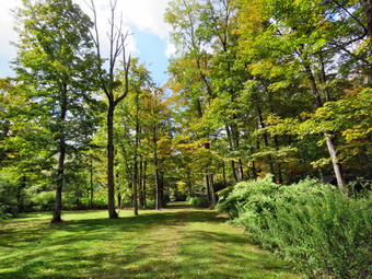
![]() On Thursday, September 18th I had planned to go on a longer hike with Sheena as I though I had ambulance coverage. As it turned out I would have to cover from 6:00 AM to 12:00 PM and would only have from noon to 2:00 PM to hike. At 7:45 AM I responded to a call. After returning, I had some chores to do around the house. At 11:45 AM another call came over the pager and I was out the door. By the time I returned at 1:45 PM I was committed to covering calls. I decided to simply go across the street and hike on Round Top. Sheena was giving every indication that she thought hiking was a great idea. I started to get ready to hike with the temperature at 78 degrees on the back porch. I got dressed in a new Columbia Omni-Shade Omni-Wick shirt without a baselayer. I put on a pair of RailRiders hiking pants which are expensive but last a long time and have features like deep pockets and a generous cut which I really like. I thought about wearing a pair of low-cut and lighter hiking shoes but thought the trail might be wet and muddy. I decided to put on my Keen Durand hiking boots which fit well. I added a new pair of Xstance insoles in an effort to find the best support and cushioning for my feet. These insoles have shock absorbing gel pads, TPU arch support, and memory foam cushioning all wrapped in a breathable fabric. The insoles have been hyped by their manufacturer and seemed to be living up to their claims. I grabbed a pair of Leki Micro Vario poles I have been using for some time because they are light and lock without slipping. I put the ecollar on Sheena and turned it on. At 2:05 PM I put Sheena on her leash and we walked out the door to start the hike. We headed down the driveway and toward the street. Sheena has gotten used to walking on her leash to the end of the drive but sometimes gets nervous as we get near the road. This time she looked both ways and then looked at me and I said "Wait" to check for cars. When I said "OK", Sheena readily crossed the street and headed across the field. We walked to the back of the church and began the ascent of the steepest hill behind the church. Sheena had no problem walking up the hill except for the fact that she likes to stop and sniff very frequently. The hill is short but gets the circulation pumping and is the steepest and longest climb on the "trail." We did not stop on the way to the top of the hill and set a fast pace. Sheena is getting bigger every day and her pull on the leash is signficant. At the top we paused for only a moment so I could look around at the hills that surround the hamlet of Livingston Manor. The skies were a flat blue with no clouds. Sheena was eager to enter the woods on the trail and hopped right up the steps. The trail was completely dry.
On Thursday, September 18th I had planned to go on a longer hike with Sheena as I though I had ambulance coverage. As it turned out I would have to cover from 6:00 AM to 12:00 PM and would only have from noon to 2:00 PM to hike. At 7:45 AM I responded to a call. After returning, I had some chores to do around the house. At 11:45 AM another call came over the pager and I was out the door. By the time I returned at 1:45 PM I was committed to covering calls. I decided to simply go across the street and hike on Round Top. Sheena was giving every indication that she thought hiking was a great idea. I started to get ready to hike with the temperature at 78 degrees on the back porch. I got dressed in a new Columbia Omni-Shade Omni-Wick shirt without a baselayer. I put on a pair of RailRiders hiking pants which are expensive but last a long time and have features like deep pockets and a generous cut which I really like. I thought about wearing a pair of low-cut and lighter hiking shoes but thought the trail might be wet and muddy. I decided to put on my Keen Durand hiking boots which fit well. I added a new pair of Xstance insoles in an effort to find the best support and cushioning for my feet. These insoles have shock absorbing gel pads, TPU arch support, and memory foam cushioning all wrapped in a breathable fabric. The insoles have been hyped by their manufacturer and seemed to be living up to their claims. I grabbed a pair of Leki Micro Vario poles I have been using for some time because they are light and lock without slipping. I put the ecollar on Sheena and turned it on. At 2:05 PM I put Sheena on her leash and we walked out the door to start the hike. We headed down the driveway and toward the street. Sheena has gotten used to walking on her leash to the end of the drive but sometimes gets nervous as we get near the road. This time she looked both ways and then looked at me and I said "Wait" to check for cars. When I said "OK", Sheena readily crossed the street and headed across the field. We walked to the back of the church and began the ascent of the steepest hill behind the church. Sheena had no problem walking up the hill except for the fact that she likes to stop and sniff very frequently. The hill is short but gets the circulation pumping and is the steepest and longest climb on the "trail." We did not stop on the way to the top of the hill and set a fast pace. Sheena is getting bigger every day and her pull on the leash is signficant. At the top we paused for only a moment so I could look around at the hills that surround the hamlet of Livingston Manor. The skies were a flat blue with no clouds. Sheena was eager to enter the woods on the trail and hopped right up the steps. The trail was completely dry.
As soon as we entered the woods, I took Sheena off her leash. We started on the trail with Sheena setting a good pace. Sheena was ranging ahead of me and taking some time to explore off the trail. At the first trail junction, we continued straight up the hill with Sheena leading the way. When we reached the top of the hill, we followed the yellow trail as it turned right. We walked uphill through the field of ferns that was beginning to turn brown as temperatures at night had dipped into the low 40's. Some of the leaves on the trees were beginning to change to yellow and red but there was still plenty of green. We continued on the yellow trail up a small hill to the junction with the blue trail to the summit. I decided we would do a figure 8 so we turned right on the yellow trail. We followed the yellow trail along the base of Round Top with Sheena running ahead, waiting for me, and then running back. I did my best to keep up with her but her energy is boundless. At the next junction with the blue trail, we turned left and headed up toward the summit. Sheena showed no sign of slowing down as she ran up and down the trail. We passed by the white crossover trail and hiked up and over the highest point on the trail on public land and started down the other side. We bypassed the white crossover trail again and turned left on the switchback in the blue trail. Sheena is getting very good at making the correct turns on the figure 8 pattern that we use. We walked out into the woods and turned almost 180 degrees to head back to the main blue trail. There was one large branch hanging into the trail and I knew I could not remove it completely without a saw. At the main blue trail we turned left and headed down the main blue trail. At the junction with the yellow trail we turned left and walked along the base of Round Top. At the next junction with the blue trail we turned right and headed down the yellow trail. Where the trail meets the woods road, we turned right and continued downhill to the first trail junction. Sheena was in the lead for most of the hike and always seems to get the turns correct. The electronic collar has been working so well I hardly use it anymore. Sheena had a lot of energy left so I decided to turn around and get in another figure 8.
We turned around and walked up the woods road with Sheena pushing the pace even though she was going off trail quite a bit. At the end of the woods road we turned left on the yellow trail and headed up to the first junction with the blue trail. This area of the trail and a few others need to be trimmed before the winter season. We turned left on the yellow trail at the junction and walked along the base of Round Top to the next junction with the blue trail. Since Sheena was still interested in hiking, we turned right and headed up the blue trail toward the summit. We turned right on the switchback and headed out into the woods. We made the nearly 180 degree turn and headed back to the main blue trail. We turned right and bypassed the white crossover trail. We walked the blue trail to the summit and then started down the other side. When we came to the white trail we bypassed it and continued downhill to the junction with the yellow trail. We turned right and again walked along the base of Round Top. At the next trail junction, we turned left and headed toward the lookout. We continued downhill on the yellow trail and passed the "Sitting Rocks". We walked on the yellow trail down to the viewpoint and continued to follow the trail as it turned left. Sheena still had tons of energy left and it was hard to stop her from trying to do zoomies and run off the trail into the woods. We started to descend the trail and Sheena showed she still had a lot of energy left as she continued to run ahead and then double back. I decided to let her have her fun until we got to the first trail junction. We walked straight out to the trailhead where I put her back on the leash. We turned right to walk down the cemetery hill to the church parking lot. We walked through the parking lot to Rock Avenue and then across the street after we looked both ways. We were back at the house by 3:05 PM. We hiked for 1 hour and 5 minutes for over 2 miles of hiking. Sheena drank a lot of water and we laid down for a nap.
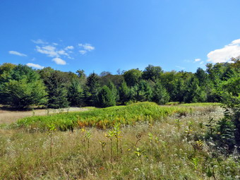
![]() On Wednesday, September 17th, Cindy and I were schedules to attend the Windsor District's monthly pastor's meeting. We normally meet at a different church each month but this months we were to meet at The Hilltop Lodge at the Hills at Windsor. This is a conference center now owned by the Assemblies of God. It has several buildings where groups can meet situated on 475 acres. There are 11 trails on the property but few are marked or maintained. After our meeting and lunch, we had been invited to walk some of the trails. The biggest drawback was that we could not take Sheena with us! I got dressed in a new Columbia Omni-Shade Omni-Wick shirt without a baselayer. I put on a pair of RailRiders hiking pants which are expensive but last a long time and have features like deep pockets and a generous cut which I really like. I thought about wearing a pair of low-cut and lighter hiking shoes but thought the trail might be wet and muddy. I decided to put on my Keen Durand hiking boots which fit well. I added a new pair of Xstance insoles in an effort to find the best support and cushioning for my feet. These insoles have shock absorbing gel pads, TPU arch support, and memory foam cushioning all wrapped in a breathable fabric. The insoles have been hyped by their manufacturer and seemed to be living up to their claims. I grabbed a pair of Leki Micro Vario poles I have been using for some time because they are light and lock without slipping. I also decided to take my pack as it adds some difficulty to short hikes and allows me to carry my camera and some supplies. I put our gear in the back of the car and Sheena in her kennel in the back room. Sheena does not like to be without us and her howling is epic. We left Livingston Manor at 8:45 AM as north and east on State Route 17 toward Binghamton. The drive seemed to go very quickly and in less than an hour we were getting off exit 78. After a few turns we were driving up Garrett Road to the top of the hill. The Hilltop Lodge was on the right side of the road just before it turned to a dirt trail. I parked in the driveway where one car was already parked. We met Kevin inside and waited for the others to arrived. Kevin gave us a tour of the lodge which was 10 beds, a kitchen, meeting rooms and bathrooms. I took some pictures of the inside of the lodge and some more of the views from a bench outside. After our meeting we ate lunch and then it was time to hike.
On Wednesday, September 17th, Cindy and I were schedules to attend the Windsor District's monthly pastor's meeting. We normally meet at a different church each month but this months we were to meet at The Hilltop Lodge at the Hills at Windsor. This is a conference center now owned by the Assemblies of God. It has several buildings where groups can meet situated on 475 acres. There are 11 trails on the property but few are marked or maintained. After our meeting and lunch, we had been invited to walk some of the trails. The biggest drawback was that we could not take Sheena with us! I got dressed in a new Columbia Omni-Shade Omni-Wick shirt without a baselayer. I put on a pair of RailRiders hiking pants which are expensive but last a long time and have features like deep pockets and a generous cut which I really like. I thought about wearing a pair of low-cut and lighter hiking shoes but thought the trail might be wet and muddy. I decided to put on my Keen Durand hiking boots which fit well. I added a new pair of Xstance insoles in an effort to find the best support and cushioning for my feet. These insoles have shock absorbing gel pads, TPU arch support, and memory foam cushioning all wrapped in a breathable fabric. The insoles have been hyped by their manufacturer and seemed to be living up to their claims. I grabbed a pair of Leki Micro Vario poles I have been using for some time because they are light and lock without slipping. I also decided to take my pack as it adds some difficulty to short hikes and allows me to carry my camera and some supplies. I put our gear in the back of the car and Sheena in her kennel in the back room. Sheena does not like to be without us and her howling is epic. We left Livingston Manor at 8:45 AM as north and east on State Route 17 toward Binghamton. The drive seemed to go very quickly and in less than an hour we were getting off exit 78. After a few turns we were driving up Garrett Road to the top of the hill. The Hilltop Lodge was on the right side of the road just before it turned to a dirt trail. I parked in the driveway where one car was already parked. We met Kevin inside and waited for the others to arrived. Kevin gave us a tour of the lodge which was 10 beds, a kitchen, meeting rooms and bathrooms. I took some pictures of the inside of the lodge and some more of the views from a bench outside. After our meeting we ate lunch and then it was time to hike.
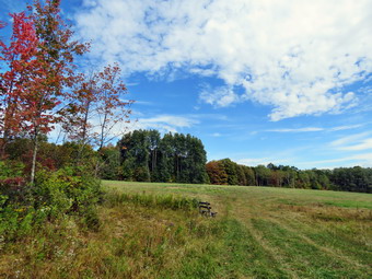 I was surprised that only Cindy and I were interested in hiking and Cindy had her doubts! Kevin gave me a map which was difficult to follow but better than nothing. I decided we would try to get to a small pond on the south of the property that could be accessed by a red trail. I estimated the distance was between 3 and 4 miles. We went to the car to get our equipment. I set my GPS to be able to find our position and keep a track of the hike. We started our hike at 1:05 PM with the temperature at 72 degrees. We walked south on a dirt and gravel road toward a series of fields. The route took us downhill for about .35 miles where the road opened into a large field. I stopped to take a few pictures of the fields with some colorful trees and interesting clouds. After I was done. We headed west on a blue trail and then almost immediately south on a red trail. The field were mowed but once we were on the trail there was high grass and weeds making the hiking more difficult. The walk continued downhill which worried Cindy as she knew the return hike would be uphill. There were a few red or pink ribbons along the trail but it was unclear if they were marking the trail and they were few and far between. I was able to match our route on the GPS and the map and we seemed to be going the right way. There were many trails and woods roads in the area. Some of these were on the map and some were not. Cindy was lagging behind even though we were walking downhill. I stopped to check the GPS and map as Cindy caught up and announced she was not having fun. I knew it was time to turn around even though we were only .8 miles and 25 minutes out. We had dropped about 200 feet over gentle terrain. I was disappointed because I like the adventure of going somewhere I have never been before. We turned around and followed our route back the way we came. Of course the return trip was uphill! At 1 mile I continued straight ahead on a woods road and immediately had the feeling I should have turned right. I checked the GPS and walked back to the turn which now looked familiar. The detour only took us .1 miles out of the way. We continued our walk back to the car without any more mistakes on my part. We were back at 2:00 PM after hiking only 1.7 miles in 55 minutes. The temperature was 76 degrees. We thanked Kevin and started home. I definitely will return to hike and maybe to stay with a group. I would like to help expand and upgrade the facilities by creating trails and maps easier for users.
![]()
![]()
![]()
![]()
![]() On Tuesday, September 16th, I planned take Sheena for a longer hike away from Livingston Manor as I had full ambulance coverage from 8:00 AM to 2:00 PM. An early morning ambulance call changed my mind. I ate breakfast at Caf� 43 and returned home by 10:00 AM. I decided to go to the Parksville Rail Trail as it is close but interesting with a nice falls. I began to get ready at 10:30 AM with right blue skies and lots of sun. The Parksville Rail Trail is under three miles out and back but keeping a quick pace helps increase the difficulty. Sheena actually does get in about twice the mileage that I do as she forges ahead and then comes back to me! I have transitioned from using a leash all the time to using a GarmimSport PRO electronic collar which has many versatile settings and seems to do the job. This allows Sheena to roam and keeps me sane by not having to yank on her leash. It seems that Sheena likes hiking as she smells my clothes and then runs to sit by the door! I got dressed in a new Columbia Omni-Shade Omni-Wick shirt without a baselayer. I put on a pair of RailRiders hiking pants which are expensive but last a long time and have features like deep pockets and a generous cut which I really like. I thought about wearing a pair of low-cut and lighter hiking shoes but thought the trail might be wet and muddy. I decided to put on my Keen Durand hiking boots which fit well. I added a new pair of Xstance insoles in an effort to find the best support and cushioning for my feet. These insoles have shock absorbing gel pads, TPU arch support, and memory foam cushioning all wrapped in a breathable fabric. The insoles have been hyped by their manufacturer and seemed to be living up to their claims. I grabbed a pair of Leki Micro Vario poles I have been using for some time because they are light and lock without slipping. I didn't bother to wear my OR floppy hat or gaiters. I also decided not to take my pack but to hike as fast as possible. I put our gear in the back of the car and Sheena in the back seat and we left Livingston Manor at 10:50 AM. I drove out Old Route 17 toward Parksville and turned left under the Quickway overpass onto Service Road. I drove toward Parksville and pulled into the parking area on the right side of the road just after Fox Mountain Rd. There was one car parked in the lot when we arrived but I could not tell if the occupants were coming or going. I made sure Sheena's ecollar was adjusted correctly and then I let her out of the car at 11:00 AM. The temperature was 70 degrees and the sun made it feel warmer.
On Tuesday, September 16th, I planned take Sheena for a longer hike away from Livingston Manor as I had full ambulance coverage from 8:00 AM to 2:00 PM. An early morning ambulance call changed my mind. I ate breakfast at Caf� 43 and returned home by 10:00 AM. I decided to go to the Parksville Rail Trail as it is close but interesting with a nice falls. I began to get ready at 10:30 AM with right blue skies and lots of sun. The Parksville Rail Trail is under three miles out and back but keeping a quick pace helps increase the difficulty. Sheena actually does get in about twice the mileage that I do as she forges ahead and then comes back to me! I have transitioned from using a leash all the time to using a GarmimSport PRO electronic collar which has many versatile settings and seems to do the job. This allows Sheena to roam and keeps me sane by not having to yank on her leash. It seems that Sheena likes hiking as she smells my clothes and then runs to sit by the door! I got dressed in a new Columbia Omni-Shade Omni-Wick shirt without a baselayer. I put on a pair of RailRiders hiking pants which are expensive but last a long time and have features like deep pockets and a generous cut which I really like. I thought about wearing a pair of low-cut and lighter hiking shoes but thought the trail might be wet and muddy. I decided to put on my Keen Durand hiking boots which fit well. I added a new pair of Xstance insoles in an effort to find the best support and cushioning for my feet. These insoles have shock absorbing gel pads, TPU arch support, and memory foam cushioning all wrapped in a breathable fabric. The insoles have been hyped by their manufacturer and seemed to be living up to their claims. I grabbed a pair of Leki Micro Vario poles I have been using for some time because they are light and lock without slipping. I didn't bother to wear my OR floppy hat or gaiters. I also decided not to take my pack but to hike as fast as possible. I put our gear in the back of the car and Sheena in the back seat and we left Livingston Manor at 10:50 AM. I drove out Old Route 17 toward Parksville and turned left under the Quickway overpass onto Service Road. I drove toward Parksville and pulled into the parking area on the right side of the road just after Fox Mountain Rd. There was one car parked in the lot when we arrived but I could not tell if the occupants were coming or going. I made sure Sheena's ecollar was adjusted correctly and then I let her out of the car at 11:00 AM. The temperature was 70 degrees and the sun made it feel warmer.
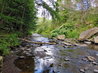
 The first part of the trail was barely damp as the sun had evaporated the rains that had fallen during recent brief showers. Off her leash Sheena would run ahead of me a certain distance and then maintain that distance by waiting for me or increasing her pace. We were soon back under the cover of the trees. Once we were hiking on the trail, we were sheltered from the sun but I was still warm. The trail was wet with soft and muddy patches in all the usual spots. The trail runs parallel to the Little Beaverkill and the new section of State Route 17. It follows the route of the O&W railroad and is very flat. Sheena was setting a quick pace and I didn't mind as long as she would listen and wait for me when necessary. The water level in the stream was very low. Shortly after starting the hike I looked up to see a young woman hiking toward us. I took Sheena by the collar and attached her leash. We continued walking and met the woman who said "Hello". Sheena seemed interested in the woman but was more interested in getting back to hiking. I let her off her leash and we continued on the trail through some muddy patches until we came to the viewpoint just before the wooden walkways. This spot has a nice view down to the stream and the skies were blue with some nice clouds. We walked across the wooden walkways which were drier and not as slippery compared to our last visit. The area before the bridge was only damp. Just after the bridge was a large patch of mud that was smaller than usual. The culvert under the bridge appeared permanently blocked and the water forms the mud. No one seems concerned about solving this problem. I walked around the mud to continue the hike but Sheena walked right through it. We came to the landslide that had brought down several trees that had been cut and cleared. This area is now muddy but there were some stepping stones. Sheena does not seem to mind sloshing through the water and wading through the mud. As we walked, we could hear the increase in noise from the stream. I looked up to see two women walking toward us and again leased Sheena until the women passed us. I let Sheena off her leash and we soon reached the falls. As we walked by I inspected them and found the water was even lower than last time.
 We pushed on toward the other end of the trail continuing toward Parksville with Sheena in the lead. I did take a peek at the stream from the bench on the trail. Within a few minutes, we were nearing the Parksville end of the trail and Sheena was eager to continue. We came to a spot in the trail where we could see the other side. The large dog that is often there was absent. We continued toward Parksville where the dogs near the end of the trail that had been absent during cold weather were barking their heads off and the resident was playing his music as if he though everyone in Parksville would enjoy it. We tagged the end of the trail when we reached the sign at the Parksville end of the rail trail. It was 11:23 AM and it had taken us 23 minutes to hike the length of the trail non-stop. I knew if we hurried back we could set a record time. We immediately turned around and started back toward the car. We set a fast pace back from the falls with Sheena in the lead. Just before we reached the falls, we met the first solo woman hiker and I pulled Sheena off the trail to let her pass. The young woman said "Cute dog" as she walked by. I released Sheena amd we soon came to the bridge, I hopped around the mud while Sheena pushed through. We continued on the trail meeting the other two women as we neared the end of trees on the trail. As we approached the end of the trail, I called Sheena and told her "With" which is the equivalent of "Heel". We arrived back at the car at 11:45 AM after hiking over 2.7 miles in 45 minutes which was our record! The temperature had risen to 76 degrees. Sheena seemed fresh and I felt she could have hiked out and back on the trail another time as could I. We returned home and we both had something to drink. There had been no other ambulance calls while we were on the trail which made me feel good.
![]()
![]()
![]()
![]()
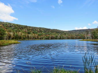
![]() On Monday, September 15th I had planned to get out and do a longer hike I had not done in some time. I had to go out for a very early morning call and then another came in at 9:00 AM and I responded. I was cancelled from the call and was back home by 10:00 AM. The day looked beautiful even though the temperature was only 60 degrees and I asked Cindy if she wanted to go for a walk. She agreed and I waited for her to get ready. I also started to get ready at 10:30 AM when the temperature was 58 degrees on the back porch and the humidity was 75%. I had full ambulance coverage until 2:00 PM and we decided we would go to Huggins Lake. This hike is about 4 miles and is always deserted. There is a long uphill stretch at the beginning and a shorter, steeper descent to the lake. The forecast did not include any rain and for temperatures in the high 70s. As soon as I started to get ready, Sheena began to run around and whine anticipating getting out of the house. I got dressed in a new Columbia Omni-Shade Omni-Wick shirt without a baselayer. I put on a pair of RailRiders hiking pants which are expensive but last a long time and have features like deep pockets and a generous cut which I really like. I thought about wearing a pair of low-cut and lighter hiking shoes but thought the trail might be wet and muddy. I decided to put on my Keen Durand hiking boots which fit well. I added a new pair of Xstance insoles in an effort to find the best support and cushioning for my feet. These insoles have shock absorbing gel pads, TPU arch support, and memory foam cushioning all wrapped in a breathable fabric. The insoles have been hyped by their manufacturer and seemed to be living up to their claims. I grabbed a pair of Leki Micro Vario poles because they are light and lock without slipping. I decided to leave my phone at home. I put on my OR Bugoff gaiters to combat the ticks which have been plentiful this year. I got our gear in the car and Sheena in the backseat. We left Livingston Manor at 10:50 AM and drove north on Old Route 17. I turned right on the Beaverkill Road and left on Campsite Road. At the bottom of the hill I turned right and drove down to the campgrounds parking area and across the Beaverkill Covered Bridge. At the end of the road I turned right and followed Berry Brook Road to the trailhead for Huggins Lake. We arrived at the road to the parking area to find it very rough with a lot erosion. It was even worse than in July when it was bad! I decided to give it a try and was able to get to the parking lot. I was not surprised to find we were the only car in the parking lot. I set my GPS unit and we started off at 11:10 AM by walking through the metal gate on the woods road. The sun was bright but we were shaded by the trees. The temperature was 66 degrees as we headed out on the wide woods road to the lake. The humidity was still high making everything feel "sticky". The hike isn't long, less than 4 miles. The trail is maintained by the DEC and we saw a few blowdowns along the way that had been cleared. There were no new blowdowns in the trail that needed to be cleared.
On Monday, September 15th I had planned to get out and do a longer hike I had not done in some time. I had to go out for a very early morning call and then another came in at 9:00 AM and I responded. I was cancelled from the call and was back home by 10:00 AM. The day looked beautiful even though the temperature was only 60 degrees and I asked Cindy if she wanted to go for a walk. She agreed and I waited for her to get ready. I also started to get ready at 10:30 AM when the temperature was 58 degrees on the back porch and the humidity was 75%. I had full ambulance coverage until 2:00 PM and we decided we would go to Huggins Lake. This hike is about 4 miles and is always deserted. There is a long uphill stretch at the beginning and a shorter, steeper descent to the lake. The forecast did not include any rain and for temperatures in the high 70s. As soon as I started to get ready, Sheena began to run around and whine anticipating getting out of the house. I got dressed in a new Columbia Omni-Shade Omni-Wick shirt without a baselayer. I put on a pair of RailRiders hiking pants which are expensive but last a long time and have features like deep pockets and a generous cut which I really like. I thought about wearing a pair of low-cut and lighter hiking shoes but thought the trail might be wet and muddy. I decided to put on my Keen Durand hiking boots which fit well. I added a new pair of Xstance insoles in an effort to find the best support and cushioning for my feet. These insoles have shock absorbing gel pads, TPU arch support, and memory foam cushioning all wrapped in a breathable fabric. The insoles have been hyped by their manufacturer and seemed to be living up to their claims. I grabbed a pair of Leki Micro Vario poles because they are light and lock without slipping. I decided to leave my phone at home. I put on my OR Bugoff gaiters to combat the ticks which have been plentiful this year. I got our gear in the car and Sheena in the backseat. We left Livingston Manor at 10:50 AM and drove north on Old Route 17. I turned right on the Beaverkill Road and left on Campsite Road. At the bottom of the hill I turned right and drove down to the campgrounds parking area and across the Beaverkill Covered Bridge. At the end of the road I turned right and followed Berry Brook Road to the trailhead for Huggins Lake. We arrived at the road to the parking area to find it very rough with a lot erosion. It was even worse than in July when it was bad! I decided to give it a try and was able to get to the parking lot. I was not surprised to find we were the only car in the parking lot. I set my GPS unit and we started off at 11:10 AM by walking through the metal gate on the woods road. The sun was bright but we were shaded by the trees. The temperature was 66 degrees as we headed out on the wide woods road to the lake. The humidity was still high making everything feel "sticky". The hike isn't long, less than 4 miles. The trail is maintained by the DEC and we saw a few blowdowns along the way that had been cleared. There were no new blowdowns in the trail that needed to be cleared.
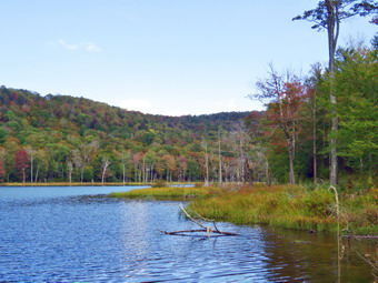 The first 1.2 miles is all uphill and gains almost 700 feet. Sheena was running up and down the trail following game paths into the woods. I often wonder how many miles she puts on as I plod along the trails. At times she would come back and check on us and then she was off again. I had feared long, wet grass on the trail but the grass was short and relatively dry. We did run into some patches of stinging nettles in the samper spots. There was no mud on the trail and everything was very dry. The ascent has several spots which appear to be the top of the climb but are not. Cindy and I were setting a good pace and we both seemed to be doing ok. In fact, Cindy was ahead setting the pace! After the initial climb, the trail descends, levels some and then climbs again until the final descent to Huggins Lake. There is a flat spot at the highest point which is about 20 feet long! As we continued, the trail made a sharp turn from southeast to north at about 1.6 miles. We enjoyed the downhill trek to the shores of the pond. The downhill walk is .65 miles from the highest point and the elevation drop is 250 feet. This means Huggins Lake is at a much higher elevation than the trailhead. As we walked down the hill to the pond, I knew we would soon have to turn around and climb back up the hill. When we arrived at the lake at 12:05 PM, I noticed that the water level was higher than any place I had visited lately. I dropped my pack and got out my camera to take pictures of the lake. The sky was blue with towering white clouds. Most of the trees were still green but some were changing color and a few were beautiful in reds or yellows. I took some pictures of the lake and the hills that surround it. At the outlet I could immediately see that the beavers had dammed the water flow and that reeds had grown to all but block all nut a few streams of the outlet flow. I thought Sheena might take a dip in the water but she stayed on dry ground which was good as the water was a little slimmy. I took a few more pictures of the lake and dome of the flowering weeds that were almost head high. I returned to my pack and stowed the camera. I packed up and we started back up the hill at 11:15 AM. The only negative point about Huggins Lake is that there is only one trail and so there are no variations available unless you bushwhack. I had thought about bushwhacking around the lake but the ascent on the other side is very steep. The ascent on the woods road went smoothly for the most part as we climbed the hill back to the highest point on the trail. I was glad Cindy was along because our conversation and company made the hike seem shorter and our effrts seem easier. I let Sheena lead on the way back and she outpaced us at the entire way despite her excursion off trail chasing chipmunks. The climb from the lake seemed easier than I remembered and we were soon at the highest point on the hike. From the high point we started down the other side of the hill on the trail. Downhill was definitely easier than uphill! Sheena seemed very interested in following game trails off the main trail and I had to keep calling her back. From the highest point it was all downhill to the car. We almost seemed to be jogging downhill at times being careful to avoid tripping over rocks and roots. We arrived back at the car at 1:05 PM after hiking 3.7 miles in 1 hour and 55 minutes with 12 minutes of stopped time and a total elevation gain of 940 feet. Our moving speed was 2.1 MPH with an overall speed of 2.0 MPH.
![]()
![]()
![]()
![]()
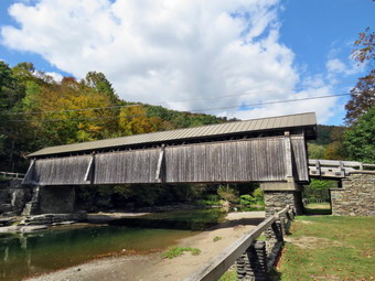
![]() On Friday, September 12th, I wanted to get out for a short hike near home for the exercise and for the relaxation. I had ambulance coverage from 8:00AM to 2:00 PM which allowed me some freedom. I thought about going to the Beaverkill Campgrounds to see the level of the water in the stream after the recent lack of significant rainfall. I asked Cindy if she wanted to go and she agreed. As we started to get ready at 10:30 PM the temperature was 72 degrees on the back porch with sunny skies and some puffy white clouds. As usual, Sheena was excited but was trying to be the "good dog". I got dressed in a new Columbia Omni-Shade Omni-Wick shirt without a baselayer. I put on a pair of RailRiders hiking pants which are expensive but last a long time and have features like deep pockets and a generous cut which I really like. I thought about wearing a pair of low-cut and lighter hiking shoes but thought the trail might be wet and muddy. I decided to put on my Keen Durand hiking boots which fit well. I added a new pair of Xstance insoles in an effort to find the best support and cushioning for my feet. These insoles have shock absorbing gel pads, TPU arch support, and memory foam cushioning all wrapped in a breathable fabric. The insoles have been hyped by their manufacturer and seemed to be living up to their claims. I grabbed a pair of Leki Micro Vario poles because they are light and lock without slipping. I decided to leave my phone at home. I put our gear in the back of the car and Sheena in the back seat and we left the house at 10:45 AM. I drove out Old Route 17 toward Roscoe and turned right on Beaverkill Road. As we started the descent into the Beaverkill Valley, I turned left on Campsite Road and followed it down to the parking area near the Beaverkill Covered Bridge. There was one car parked in the lot as I pulled in and parked. A glance at the river showed that the level was very low. The sandy beach was wide and dry and the rock I usually stand on to take pictures was completely exposed.
On Friday, September 12th, I wanted to get out for a short hike near home for the exercise and for the relaxation. I had ambulance coverage from 8:00AM to 2:00 PM which allowed me some freedom. I thought about going to the Beaverkill Campgrounds to see the level of the water in the stream after the recent lack of significant rainfall. I asked Cindy if she wanted to go and she agreed. As we started to get ready at 10:30 PM the temperature was 72 degrees on the back porch with sunny skies and some puffy white clouds. As usual, Sheena was excited but was trying to be the "good dog". I got dressed in a new Columbia Omni-Shade Omni-Wick shirt without a baselayer. I put on a pair of RailRiders hiking pants which are expensive but last a long time and have features like deep pockets and a generous cut which I really like. I thought about wearing a pair of low-cut and lighter hiking shoes but thought the trail might be wet and muddy. I decided to put on my Keen Durand hiking boots which fit well. I added a new pair of Xstance insoles in an effort to find the best support and cushioning for my feet. These insoles have shock absorbing gel pads, TPU arch support, and memory foam cushioning all wrapped in a breathable fabric. The insoles have been hyped by their manufacturer and seemed to be living up to their claims. I grabbed a pair of Leki Micro Vario poles because they are light and lock without slipping. I decided to leave my phone at home. I put our gear in the back of the car and Sheena in the back seat and we left the house at 10:45 AM. I drove out Old Route 17 toward Roscoe and turned right on Beaverkill Road. As we started the descent into the Beaverkill Valley, I turned left on Campsite Road and followed it down to the parking area near the Beaverkill Covered Bridge. There was one car parked in the lot as I pulled in and parked. A glance at the river showed that the level was very low. The sandy beach was wide and dry and the rock I usually stand on to take pictures was completely exposed.
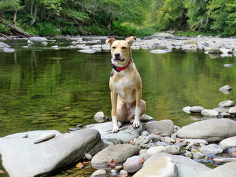 I put Sheena on her leash and we started our hike at 12:00 PM by walking out of the parking lot to the bridge with the temperature at 66 degrees. When we got to the other side, the gate that normally blocks the road along the river and through the old campsites was open. I looked at the trail and saw that it was completely bare and dry and had been mowed. We turned left on a woods road that parallels the river and started down the short hill. I let Sheena off her leash but she heard some noise and was heading in the wrong direction. I reached for the ecollar remote to encourage her to behave and found I had forgotten it! She calmed down with voice commands and I put her back on her leash. I stowed my poles under a rock and we continued down the path. I had decided to take some pictures on the way out. When we got to the spring house on the right I found there was no water so pictures would be uninteresting. I turned my attention to the small streambed next to the spring house and found it was almost dry with a thin layer of mudd. Again no chance to take pictures. When we got to the first culvert, I noticed that the path down to the edge of the stream was completely eroded and very steep. Without poles, I was not going to try to negotiate this path. I walked along the bank a few feet to try to get a view of the covered bridge so we continued on the deserted woods road. The stream was almost silent as the water level was so low, The landscape including the mowed grass and the picnic tables contrasted nicely with the sunlight and blue skies. The whole area had a serene feel enhanced by the sound of the flowing water. On the trail we passed by several areas with picnic tables. These tables sit unused and rotting along the road, a testimony to better days when this area had camping areas. Now this area is used for day use. We walked by more tables which had not been used in years. I did stop at one point to take some pictures of the tables that were in better condition. A little later we came to what was once a bathroom for some campsites that had long since disappeared. There were more tables in this area. We stopped and I walked to the stream where rocks had been piled up and contained by wire screen. I walked to the edge and stood on some rocks to take more pictures of the stream in both directions. Sheena came over and stood on the wall next to me. The rapids in this area were greatly reduced compared to the normal water level and the sunlight was playing off the water. I returned to the picnic table where I left my pack and took a few shots of the bathroom and the woods road before we continued on the woods road. At about .7 miles into the hike the woods road met the paved road that serves the campsites. I made sure to put Sheena back on her leash. I stopped to take some pictures of the empty campsites. We continued on the road through the campsites and along the river. Many of the campsites have a cement block fireplace with a grill but some were upgraded to poured concrete. Everything was very quiet except for the water in the river. This was not surprising as the campsites were closed.
 We walked along the paved road to the last campsite where the road ends and I walked down to the edge of the river. I was careful to watch where I was walking but the water level was low which allowed me to walk farther out into the stream to get pictures from a different location and angle. Sheena decided she wanted to wade a little a get a short drink. I tried to get a few shots of her in the water. I stopped to take some pictures of the river especially downstream. When Sheena came out of the water, I had her pose on a rock and took some shots of her downstream. We turned around amd walked back passed the last campsite. We continued on the campsite road toward the last bathroom. Where the road split, there was a gathering of picnic tables and I took a few shots. I also took some shots of the bathroom and the clouds overhead. We stayed to the left to walk the parallel section of road back through the campsites. This road parallels the one we walked out on to make a sort of loop. I stopped again to take pictures of the volleyball net and the towering clouds. We continued along the woods road to the maintenance building and stayed right to walk back toward the parking area. We returned the way we had come although at a quicker pace. We continued our hike and I began to look to the left where the land rose out of the valley to a ridge. I could see that the land leveled off part of the way up and then started up again. I had walked up a path to this area on a previous hike and had no intention of trying it again as I was looking for something new. I had wanted to start further back but will save that for another time. We passed the spring house on the main campsite road. As we walked up the hill to the road, I retrieved my poles from under a rock. We turned right to walk through the bridge. Before going through the bridge, I too some shots of the river upstream of the bridge. There was one deep pool but there was also an enormous shoal of round rocks. At the end of the bridge, we turned right to head back to the car. Cindy and Sheena got in the car and I stowed my poles and my pack. I got out the camera and walked over to the river. I walked out onto a large rock and took picture downstream. When I turned to take pictures of the bridge, I noticed a woman sitting on a rock. It did not look like the woman was going to move so I took pictures anyway. I returned to the car at 1:20 PM having hiked 2.8 miles in 1 hour and 20 minutes with plenty of stopped time for pictures. The car's thermometer read 68 degrees.
![]()
![]()
![]()
![]()
![]() On Thursday, September 11th I wanted to get out on a longer hike with Sheena. I had ambulance coverage from 8:00 AM to 4:00 PM but as luck would have it a call came in at 7:30 AM! The patient needed a procure that could not be dome at Catskill so we headed for Middletown. I was done by 10:30 AM so I decided to immediately go hiking. Cindy was at her Bible study so it was just Sheena and I so I chose to go to Frick Pond and bushwhack the ledges between the Flynn Trail and Mongaup Pond. We would then return on the snowmobile trail and the Big Rock Trail passing by Frick Pond. I did not remember doing this specific hike but estimates it was over 5 miles. I did remember that the bushwhack down the cliffs was interesting. The thermometer read over 70 degrees but it was in the direct sun so I expected it was actually cooler outside. I began to get ready at 10:45 AM with Sheena on my heels the whole time sensing we would be going out. I got dressed in a new Columbia Omni-Shade Omni-Wick shirt without a baselayer. I put on a pair of RailRiders hiking pants which are expensive but last a long time and have features like deep pockets and a generous cut which I really like. I thought about wearing a pair of low-cut and lighter hiking shoes but thought the trail might be wet and muddy. I decided to put on my Keen Durand hiking boots which fit well. I added a new pair of Xstance insoles in an effort to find the best support and cushioning for my feet. These insoles have shock absorbing gel pads, TPU arch support, and memory foam cushioning all wrapped in a breathable fabric. The insoles have been hyped by their manufacturer and seemed to be living up to their claims. I grabbed a pair of Leki Micro Vario poles because they are light and lock without slipping. We left the house at 11:00 AM to drive out DeBruce Road for about 6 miles to Mongaup Pond Road. I turned left and drove to where the road split and stayed left on Beech Mountain Road. When we arrived at the parking area there were no cars in either lot. I parked in the small lot and got ready to hike. I set my GPS and we started our hike by crossing the road at 11:25 AM with the temperature at 66 degrees. The trail was damp places but there was no mud. We continued on the Flynn Trail to the woods road. We turned right on the woods road which was once an extension of Beech Mountain Road and started our climb. We kept up a quick pace talking as we walked until we came to the spot where there is a clearing a little off the trail on the right at 1.15 miles. We turned into the woods and walked a path up to the clearing. I took my pack off and got the camera to take some pictures of the clearing. No one seems to know eagerly why the clearing is there but some speculate the dirt was used to build the Beech Mountain Road up to the Boy Scout camp. The clearing has a thin layer of dirt over bedrock and is unusual since it supports a wide variety of plants. There is a thick layer of moss in most place and the moss represents several different species. The area is often quite wet but on this day it was dry. I put my camera away and picked up my pack to walk toward the treeline trying to find a break where we could begin our bushwhack east to Mongaup Pond. I found a spot and we started walking through the mostly open woods heading east and slightly southeast. Sheena seemed to love running through the woods but never got far from me.
On Thursday, September 11th I wanted to get out on a longer hike with Sheena. I had ambulance coverage from 8:00 AM to 4:00 PM but as luck would have it a call came in at 7:30 AM! The patient needed a procure that could not be dome at Catskill so we headed for Middletown. I was done by 10:30 AM so I decided to immediately go hiking. Cindy was at her Bible study so it was just Sheena and I so I chose to go to Frick Pond and bushwhack the ledges between the Flynn Trail and Mongaup Pond. We would then return on the snowmobile trail and the Big Rock Trail passing by Frick Pond. I did not remember doing this specific hike but estimates it was over 5 miles. I did remember that the bushwhack down the cliffs was interesting. The thermometer read over 70 degrees but it was in the direct sun so I expected it was actually cooler outside. I began to get ready at 10:45 AM with Sheena on my heels the whole time sensing we would be going out. I got dressed in a new Columbia Omni-Shade Omni-Wick shirt without a baselayer. I put on a pair of RailRiders hiking pants which are expensive but last a long time and have features like deep pockets and a generous cut which I really like. I thought about wearing a pair of low-cut and lighter hiking shoes but thought the trail might be wet and muddy. I decided to put on my Keen Durand hiking boots which fit well. I added a new pair of Xstance insoles in an effort to find the best support and cushioning for my feet. These insoles have shock absorbing gel pads, TPU arch support, and memory foam cushioning all wrapped in a breathable fabric. The insoles have been hyped by their manufacturer and seemed to be living up to their claims. I grabbed a pair of Leki Micro Vario poles because they are light and lock without slipping. We left the house at 11:00 AM to drive out DeBruce Road for about 6 miles to Mongaup Pond Road. I turned left and drove to where the road split and stayed left on Beech Mountain Road. When we arrived at the parking area there were no cars in either lot. I parked in the small lot and got ready to hike. I set my GPS and we started our hike by crossing the road at 11:25 AM with the temperature at 66 degrees. The trail was damp places but there was no mud. We continued on the Flynn Trail to the woods road. We turned right on the woods road which was once an extension of Beech Mountain Road and started our climb. We kept up a quick pace talking as we walked until we came to the spot where there is a clearing a little off the trail on the right at 1.15 miles. We turned into the woods and walked a path up to the clearing. I took my pack off and got the camera to take some pictures of the clearing. No one seems to know eagerly why the clearing is there but some speculate the dirt was used to build the Beech Mountain Road up to the Boy Scout camp. The clearing has a thin layer of dirt over bedrock and is unusual since it supports a wide variety of plants. There is a thick layer of moss in most place and the moss represents several different species. The area is often quite wet but on this day it was dry. I put my camera away and picked up my pack to walk toward the treeline trying to find a break where we could begin our bushwhack east to Mongaup Pond. I found a spot and we started walking through the mostly open woods heading east and slightly southeast. Sheena seemed to love running through the woods but never got far from me.
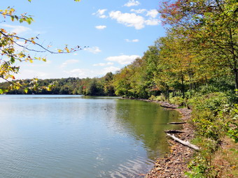 In less than a quarter mile from the clearing we came to the first series of ledges and found a way to descend through them. Just before I started down, I looked ahead and saw the water of Mongaup Pond ahead. I look at my GPS and we were only .4 miles away from the pond. I took a few shots of the rock ledges and the "caves" under them. We continued to work our way down being careful of our steps as the dry leaves were slippery and there were plenty of loose rocks. The grade was pretty steep averaging about 18%. We worked our way down through another level and I took a few more pictures including some of Sheena sitting beneath the ledges. We continued to descend and turn a little more to the southeast. I was having trouble finding the woods road that I hag used before and checked my GPS to make sure we were headed in the best direction. Sheena was up ahead and seems to be following a trail. I told her to "Stay" and I caught up to her. Sheena had found the overgrown woods road heading southeast so we started to follow it. The road paralleled a drainage which conducts water down toward the pond. Sooner than I thought we were at the loop road around the pond. We turned left and we walked the road north until we came to the area on the right where there is a bench and a nice view of the pond. I put my pack on the bench and got out the camera to take pictures of the pond in different directions, angles, and zooms. The campgrounds had closed earlier than usual due to lack of staffing. This made the area very quiet and serene. The only noses we could hear were some maintenance workers cutting grass. There were some geese and one lone duck on the water. The clouds over Mongaup Pond were magnificent and the lighting was spectacular. I almost decided to sit down for a while but knew I had a few miles to hike. When I was done I got a drink and a bar feeling particularly energetic. Sheena also asked for a drink and I gave her one in the portable dish I carry. We walked out to the road and turned right continuing north. We soon came to some campsites on the left and Sheena investigated each one. At campsite 159 we found the snowmobile trail that would take us back up the hill to the Flynn Trail.
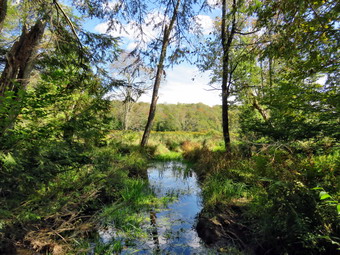 The first part of the trail runs along a swamp and is normally very wet and muddy. I found almost no mud and no standing water which made the trip much easier. The trail beagn to climb at 2.7 miles and slowly turned from north to northwest until at 3.3 miles it turned due south. The climb continued and at 3.7 miles it turned west. Sheena was having a great time chasing squirrels and chipmunks off the trail. At several points I saw her start to chase something large but she came right back when I called. The weather was ideal for hiking with low humidity and a slight breeze. I never felt too hot or too cold. When we reached 4 miles into the hike the trail turned north and reached the highest point of 2866 feet at 4.4 miles. At this point we had climbed 700 feet in 1.75 miles and I was ready for some downhill hiking. We walked downhill and at 4.7 miles we were at the junction of the Flynn and Big Rock Trails. We continued straight ahead on the Big Rock Trail headed for Times Square. The Big Rock Trail was a welcome change as it descends 590 feet over 1.1 miles to Times Square. The trail has several spots where it seems you are at the bottom but it then continues. This can be discouraging but in this day I did not notice it. By 2:50 PM we had reached Times Square where we walked straight across to continue on the Big Rock Trail. There were a few muddy spots along this trail before we walk under the evergreen trees. The trail in this area had a deep layer of needles on the ground making a soft surface for walking.
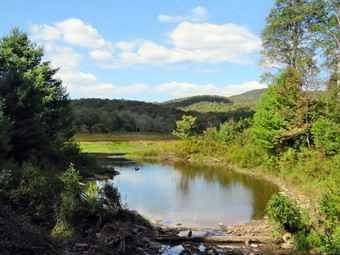 We came to the bridges over the inlet streams and I stopped to take some pictures. There was more water in the inlet streams than anywhere else but they were still very low. I completed my photography and we walked across the second bridge and continued beneath some more evergreens. As we approached the wooden walkways I decided to take a few shots before walking over them. The walkways continue to deteriorate without any attention from the DEC. After the walkways we approached the junction with the Quick Lake Trail. This area also had a few muddy spots compared to the mud pits often found here. At the junction we turned left and continued on the Quick Lake Trail to the bridge at the outlet of Frock Pond. I put my pack down and took out the camera to snap some pictures. I was surprised to see that someone had cleaned up the area of the dam removing a small sapling. I took pictures of the small dam which was not needed as there was no water flowing in the outlet stream. When I was done, we walked up the small hill and came to Gravestone Junction. We continued straight ahead on the Quick Lake Trail toward the parking area. The trail was nearly dry and the walk went quickly. We passed the register and were soon back at the car without seeing another person. The temperature at the car was 68 degrees which was only a few degrees warmer than when we had started. It was 3:25 PM and I had hiked 6.8 miles in just under 4 hours with 30 minutes of stopped time. The total elevation gain of 1340 feet. I checked my records at home and found I had done this hike before. WI checked the GPS track at home I found our bushwhack almost exactly followed the route I had taken before!
![]()
![]()
![]()
![]()
![]() On Wednesday, September 10th, I had full ambulance coverage from 6:00 AM to 2:00 PM and wanted to get in a hike with Cindy and Sheena. At 9:30 AM an ambulance call came in and decided to first respond. I evaluated the patient and provided care until the ambulance arrived. We moved the patient to the rig and I was home by 10:30 AM. I asked Cindy if she would like to hike the Parksville Rail Trail and she said "Yes". The temperature was 70 degrees with sun and some clouds and the conditions were ideal for hiking. The Parksville Rail Trail is close to home but has an interesting waterfall. It is under three miles out and back but keeping a quick pace helps increase the difficulty. Sheena actually does get in about twice the mileage that we do as she forges ahead and then comes back! I have transitioned from using a leash all the time to using a GarmimSport PRO electronic collar which has many versatile settings and seems to do the job. This allows Sheena to roam and keeps me sane by not having to yank on her leash. It seems that Sheena likes hiking as she smells my clothes and then runs to sit by the door! I got dressed in a new Columbia Omni-Shade Omni-Wick shirt without a baselayer. I put on a pair of RailRiders hiking pants which are expensive but last a long time and have features like deep pockets and a generous cut which I really like. I thought about wearing a pair of low-cut and lighter hiking shoes but thought the trail might be wet and muddy. I decided to put on my Keen Durand hiking boots which fit well. I added a new pair of Xstance insoles in an effort to find the best support and cushioning for my feet. These insoles have shock absorbing gel pads, TPU arch support, and memory foam cushioning all wrapped in a breathable fabric. The insoles have been hyped by their manufacturer and seemed to be living up to their claims. I grabbed a pair of Leki Makalu Lite poles I have been using for some time because they are light and lock without slipping. I decided not to take my pack as the pictures I would take would be much the same as on several past trips. (The pictures displayed here are from a late August trip.) We put our gear in the back of the car and Sheena in the back seat and we left Livingston Manor at 10:45 AM. I drove out Old Route 17 toward Parksville and turned left under the Quickway overpass onto Service Road. I drove toward Parksville and pulled into the parking area on the right side of the road just after Fox Mountain Rd. There were no cars in the lot as we parked with the temperature at 70 degrees. I made sure Sheena's ecollar was adjusted correctly and turned it on.
On Wednesday, September 10th, I had full ambulance coverage from 6:00 AM to 2:00 PM and wanted to get in a hike with Cindy and Sheena. At 9:30 AM an ambulance call came in and decided to first respond. I evaluated the patient and provided care until the ambulance arrived. We moved the patient to the rig and I was home by 10:30 AM. I asked Cindy if she would like to hike the Parksville Rail Trail and she said "Yes". The temperature was 70 degrees with sun and some clouds and the conditions were ideal for hiking. The Parksville Rail Trail is close to home but has an interesting waterfall. It is under three miles out and back but keeping a quick pace helps increase the difficulty. Sheena actually does get in about twice the mileage that we do as she forges ahead and then comes back! I have transitioned from using a leash all the time to using a GarmimSport PRO electronic collar which has many versatile settings and seems to do the job. This allows Sheena to roam and keeps me sane by not having to yank on her leash. It seems that Sheena likes hiking as she smells my clothes and then runs to sit by the door! I got dressed in a new Columbia Omni-Shade Omni-Wick shirt without a baselayer. I put on a pair of RailRiders hiking pants which are expensive but last a long time and have features like deep pockets and a generous cut which I really like. I thought about wearing a pair of low-cut and lighter hiking shoes but thought the trail might be wet and muddy. I decided to put on my Keen Durand hiking boots which fit well. I added a new pair of Xstance insoles in an effort to find the best support and cushioning for my feet. These insoles have shock absorbing gel pads, TPU arch support, and memory foam cushioning all wrapped in a breathable fabric. The insoles have been hyped by their manufacturer and seemed to be living up to their claims. I grabbed a pair of Leki Makalu Lite poles I have been using for some time because they are light and lock without slipping. I decided not to take my pack as the pictures I would take would be much the same as on several past trips. (The pictures displayed here are from a late August trip.) We put our gear in the back of the car and Sheena in the back seat and we left Livingston Manor at 10:45 AM. I drove out Old Route 17 toward Parksville and turned left under the Quickway overpass onto Service Road. I drove toward Parksville and pulled into the parking area on the right side of the road just after Fox Mountain Rd. There were no cars in the lot as we parked with the temperature at 70 degrees. I made sure Sheena's ecollar was adjusted correctly and turned it on.
The first part of the trail before the trees was slightly damp as the sun had evaporated the any rain. Sheena ran ahead and then came back toward us. Off her leash Sheena runs ahead of us a certain distance and then maintains that distance by waiting or increasing her pace. We were soon under the cover of the trees and Cindy amd I both agreed it felt cooler but still pleasant. Once we were hiking on the trail, we were sheltered from the sun but I was still warm. The trail was damp with soft and muddy patches in all the usual spots. The trail runs parallel to the Little Beaverkill and the new section of State Route 17. It follows the route of the O&W railroad and is very flat. Sheena was setting a quick pace and I didn't mind as long as she would listen and wait for us when necessary. We continued on the trail and I noticed the water level in the stream was lower than on the previous trip. We continued on the trail through some muddy patches until we came to the viewpoint just before the wooden walkways. This spot has a nice view down to the stream and the skies were blue with some clouds. The problem is the viewpoint is partially blocked by trees and bushes. I had already decided not to stop for pictures on this trip anyway. As we were getting ready to cross the walkways, we heard a racket and saw a golf cart coming toward us over the bridges. Sheena heard the noise and saw the cart and bolted down therapy back toward the car. I asked the boys in the cart to stop until I caught Sheena and they stopped where they were. I followed Sheena but each time I got close she ran further on the trail. I tried the ecollar but she did not respond. Eventually I managed to get her to come to me andI put her on her leash. We walked back toward the bridges but when Sheena saw the cart she would not budge. I motioned for the cart to continue on the trail and held on the Sheena's collar athey passed. Sheena and I walked back to Cindy where I took Sheena off her leash. It was then that I discovered that I had failed to turn on he ecollar! We walked across the wooden walkways which were wet and slippery. The area before the bridge was only damp. Just after the bridge was a patch of mud from one side of the trail to the other. The culvert under the bridge appeared permanently blocked and the water forms the mud. No one seems concerned about solving this problem. We walked around the mud to continue the hike but Sheena walked right through it. We came to the landslide that had brought down several trees that had been cut and cleared. This area is now muddy but there were some stepping stones. Sheena does not seem to mind sloshing through the water and wading through the mud. As we walked, we could hear the increase in noise from the stream.
When we reached the falls, I looked at the falls and the water level was lower than last time. We continued on the trail but I then noticed a young woman standing by the sign that describes the fish found in the stream. I put Sheena on her leash and we walked by saying "hello". We continued on the trail toward Parksville and within a few minutes we were nearing the Parksville end of the trail. Sheena was eager to continue even when we came to a spot in the trail where we could see the other side. The large dog that is often there was absent. We continued toward Parksville where the dogs near the end of the trail were missing in action. We turned around and immediately started back toward the car at a rapid pace. We came to the falls and continued our quick pace with Sheena in the lead. At some point I noticed Cindy had stopped for a moment and I continued at a slower pace. Eventually I turned around and saw Cindy searching for something on the side of the trail. I walked back to her and she said she thought she might have dropped her phone. There was no phone in sight so we started back toward the car at an increased rate. Sheena began to run up and down the trail and work off her energy ignoring the fact that she was running through water and mud. She took advantage of the freedom and ran an extra-long distance before turning around and roaring back passed us. When we came to the bridge, we hopped around the mud while Sheena pushed through. We arrived back at the car at 12:15 PM after hiking over 2.7 miles in 1 hour and 15 minutes. The temperature at the car was 72 degrees. When we got home I found there had been no ambulance calls.
![]()
![]()
![]()
![]() On Tuesday, September 9th I had planned to go on a longer hike to bushwhack the ledges on the west side of Mongaup Pond. I had some chores to do around the house and by the time I was done I decided to simply go across the street and hike on Round Top. Sheena was giving every indication that she thought hiking was a great idea. I had ambulance coverage only until 2:00 PM and at 3:30 PM I was going to my grandson's Bryce home cross country meet. At 10:30 AM I started to get ready to hike with the temperature at 72 degrees on the back porch. I got dressed in a new Columbia Omni-Shade Omni-Wick shirt without a baselayer. I put on a pair of RailRiders hiking pants which are expensive but last a long time and have features like deep pockets and a generous cut which I really like. I thought about wearing a pair of low-cut and lighter hiking shoes but thought the trail might be wet and muddy. I decided to put on my Keen Durand hiking boots which fit well. I added a new pair of Xstance insoles in an effort to find the best support and cushioning for my feet. These insoles have shock absorbing gel pads, TPU arch support, and memory foam cushioning all wrapped in a breathable fabric. The insoles have been hyped by their manufacturer and seemed to be living up to their claims. I grabbed a pair of Leki Makalu Lite poles I have been using for some time because they are light and lock without slipping. I grabbed my OR floppy hat and but left home my OR Bugout gaiters. I put the ecollar on Sheena and turned it on. At 11:00 AM I put Sheena on her leash and we walked out the door to start the hike. We headed down the driveway and toward the street. Sheena has gotten used to walking on her leash to the end of the drive but sometimes gets nervous as we get near the road. This time she looked both ways and then looked at me and I said "OK" because there were no cars. She readily crossed the street and headed across the field. We walked to the back of the church and began the ascent of the steepest hill behind the church. Sheena had no problem walking up the hill except for the fact that she likes to stop and sniff very frequently. The hill is short but gets the circulation pumping and is the steepest and longest climb on the "trail." We did not stop on the way to the top of the hill and set a fast pace. Sheena is getting bigger every day and her pull on the leash is signficant. At the top we paused for a minute so I could look around at the hills that surround the hamlet of Livingston Manor. The skies were a blue with no clouds. Sheena was eager to enter the woods on the trail and hopped right up the steps. The trail was completely dry.
On Tuesday, September 9th I had planned to go on a longer hike to bushwhack the ledges on the west side of Mongaup Pond. I had some chores to do around the house and by the time I was done I decided to simply go across the street and hike on Round Top. Sheena was giving every indication that she thought hiking was a great idea. I had ambulance coverage only until 2:00 PM and at 3:30 PM I was going to my grandson's Bryce home cross country meet. At 10:30 AM I started to get ready to hike with the temperature at 72 degrees on the back porch. I got dressed in a new Columbia Omni-Shade Omni-Wick shirt without a baselayer. I put on a pair of RailRiders hiking pants which are expensive but last a long time and have features like deep pockets and a generous cut which I really like. I thought about wearing a pair of low-cut and lighter hiking shoes but thought the trail might be wet and muddy. I decided to put on my Keen Durand hiking boots which fit well. I added a new pair of Xstance insoles in an effort to find the best support and cushioning for my feet. These insoles have shock absorbing gel pads, TPU arch support, and memory foam cushioning all wrapped in a breathable fabric. The insoles have been hyped by their manufacturer and seemed to be living up to their claims. I grabbed a pair of Leki Makalu Lite poles I have been using for some time because they are light and lock without slipping. I grabbed my OR floppy hat and but left home my OR Bugout gaiters. I put the ecollar on Sheena and turned it on. At 11:00 AM I put Sheena on her leash and we walked out the door to start the hike. We headed down the driveway and toward the street. Sheena has gotten used to walking on her leash to the end of the drive but sometimes gets nervous as we get near the road. This time she looked both ways and then looked at me and I said "OK" because there were no cars. She readily crossed the street and headed across the field. We walked to the back of the church and began the ascent of the steepest hill behind the church. Sheena had no problem walking up the hill except for the fact that she likes to stop and sniff very frequently. The hill is short but gets the circulation pumping and is the steepest and longest climb on the "trail." We did not stop on the way to the top of the hill and set a fast pace. Sheena is getting bigger every day and her pull on the leash is signficant. At the top we paused for a minute so I could look around at the hills that surround the hamlet of Livingston Manor. The skies were a blue with no clouds. Sheena was eager to enter the woods on the trail and hopped right up the steps. The trail was completely dry.
As soon as we entered the woods, I took Sheena off her leash. We started on the trail with Sheena setting a good pace. Sheena was ranging ahead of me and taking some time to explore off the trail. At the first trail junction, we continued straight up the hill with Sheena leading the way. When we reached the top of the hill, we followed the yellow trail as it turned right. We walked uphill through the field of ferns that was beginning to turn brown as temperatures at night that dipped into the low 40's. Some of the leaves on the trees were beginning to change to yellow and red but there was still plenty of green. We continued on the yellow trail up a small hill to the junction with the blue trail to the summit. I decided we would do a figure 8 so we turned right on the yellow trail. We followed the yellow trail along the base of Round Top with Sheena running ahead, waiting for me, and then running back. I did my best to keep up with her but her energy is boundless. At the next junction with the blue trail, we turned left and headed up toward the summit. Sheena showed no sign of slowing down as she ran up and down the trail. We passed by the white crossover trail and hiked up and over the highest point on the trail on public land and started down the other side. We bypassed the white crossover trail again and turned left on the switchback in the blue trail. Sheena is getting very good at making the correct turns on the figure 8 pattern that we use. We walked out into the woods and turned almost 180 degrees to head back to the main blue trail. There was one large branch hanging into the trail and I took the time to break off some branches but could not remove it completely without a saw. At the main blue trail we turned left and headed down the main blue trail. At the junction with the yellow trail we turned left and walked along the base of Round Top. At the next junction with the blue trail we turned right and headed down the yellow trail. Where the trail meets the woods road, we turned right and continued downhill to the first trail junction. Sheena was in the lead for most of the hike and always seems to get the turns correct. The electronic collar has been working so well I hardly use it anymore. Sheena had a lot of energy left so I decided to turn around and get in another figure 8.
We turned around and walked up the woods road with Sheena pushing the pace even though she was going off trail quite a bit. At the end of the woods road we turned left on the yellow trail and headed up to the first junction with the blue trail. This area of the trail and a few others need to be trimmed before the winter season. We turned left on the yellow trail at the junction and walked along the base of Round Top to the next junction with the blue trail. Since Sheena was still interested in hiking, we turned right and headed up the blue trail toward the summit. We turned right on the switchback and headed out into the woods. We made the nearly 180 degree turn and headed back to the main blue trail. We turned right and bypassed the white crossover trail. We walked the blue trail to the summit and then started down the other side. When we came to the white trail we bypassed it and continued downhill to the junction with the yellow trail. We turned right and again walked along the base of Round Top. At the next trail junction, we turned left and headed toward the lookout. We continued downhill on the yellow trail and passed the "Sitting Rocks". We walked on the yellow trail down to the viewpoint and continued to follow the trail as it turned left. Sheena still had tons of energy left and it was hard to stop her from trying to do zoomies and run off the trail into the woods. We started to descend the trail and Sheena showed she still had a lot of energy left as she continued to run ahead and then double back. At one point she saw something on the left side of the trail and scampered up the nearly vertical bank to look around. I decided to let her have her fun until we got to the first trail junction. We walked straight out to the trailhead where I put her back on the leash. We turned right to walk down the cemetery hill to the church parking lot. We walked through the parking lot to Rock Avenue. We walked across the road after we looked both ways. We were back at the house by 1:10 PM. We hiked for 1 hour and 10 minutes for over 2 miles of hiking. Sheena drank a lot of water and then laid down by me for a nap.
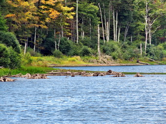
![]()
![]()
![]()
![]()
![]() On Monday, September 8th I had coverage for ambulance calls from 11:00 Am to 4:00 PM! I wanted to get out for a hike somewhere that I had not been in some time. I decided I wanted to take Sheena and go to the area around Trout Pond. This is an area I have hiked many times but I had not been there in some time. As usual I got some extra sleep in the morning but was awakened by the pager at 9:45 AM for a lift assist call. We were back at the base with an hour and it didn't take me long to document the call. I returned home and decided we would get ready to hike with the temperature at 60 degrees with blue skies and white puffy clouds. Sheena is a Feist-Cur cross which are actual types of dogs used on farms and for hunting in the south. She loves to get out and hike. Even though she is only 1 year old she is very strong for a small dog. I am glad that I have transitioned to an ecollar and that Sheena has learned basic commands very quickly. I got dressed in a new Columbia long-sleeved shirt without a baselayer. I put on a pair of RailRiders hiking pants which are expensive but last a long time and have features like deep pockets and a generous cut which I really like. I decided to put on my Keen Durand hiking boots which fit well. I added a new pair of Xstance insoles in an effort to find the best support and cushioning for my feet. These insoles have shock absorbing gel pads, TPU arch support, and memory foam cushioning all wrapped in a breathable fabric. The insoles have been hyped by their manufacturer and seemed to be living up to their claims. I grabbed a pair of Leki Makalu Lite poles I have been using for some time because they are light and lock without slipping. I decided to wear my OR BugOut gaiters as a defense against the ticks that are looking for a warm home and a meal! I got dressed in a new Columbia long-sleeved shirt without a baselayer. I put on a pair of RailRiders hiking pants which are expensive but last a long time and have features like deep pockets and a generous cut which I really like. I decided to put on my Keen Durand hiking boots which fit well. I added a new pair of Xstance insoles in an effort to find the best support and cushioning for my feet. These insoles have shock absorbing gel pads, TPU arch support, and memory foam cushioning all wrapped in a breathable fabric. The insoles have been hyped by their manufacturer and seemed to be living up to their claims. I grabbed a pair of Leki Makalu Lite poles I have been using for some time because they are light and lock without slipping. I decided to wear my OR BugOut gaiters as a defense against the ticks that are looking for a warm home and a meal! At the last minute I grabbed my OR floppy hat. I put the electronic training collar on Sheena and made sure it was turned on. I put my gear in the back of the car and left Livingston Manor at 11:55 AM. I drove north on the Quickway towards Roscoe and got off at exit 94 heading north on Route 206 towards Downsville. After crossing the Rockland Flats and passing the Roscoe Nursing Home, I turned left on Morton Hill Road and drove to the intersection with Russell Brook Road. There were no cars sitting in the "lot" at the intersection of the two roads. People see the open space and park there without thinking about the fact that the land is private. I did not want to have to walk back up Russell Brook Road at the end of the hike so I decided to drive down the road to park in the lower lot. I drove passed the small pulloff above the upper falls as I thought I would leave this for last. I drove down to the lower parking lot and parked the car in the lot where one other car was parked. Russell Brook Falls is popular as a falls and a swimming area and people also like to camp at Trout Pond. It was late in the season and it was a weekday.
On Monday, September 8th I had coverage for ambulance calls from 11:00 Am to 4:00 PM! I wanted to get out for a hike somewhere that I had not been in some time. I decided I wanted to take Sheena and go to the area around Trout Pond. This is an area I have hiked many times but I had not been there in some time. As usual I got some extra sleep in the morning but was awakened by the pager at 9:45 AM for a lift assist call. We were back at the base with an hour and it didn't take me long to document the call. I returned home and decided we would get ready to hike with the temperature at 60 degrees with blue skies and white puffy clouds. Sheena is a Feist-Cur cross which are actual types of dogs used on farms and for hunting in the south. She loves to get out and hike. Even though she is only 1 year old she is very strong for a small dog. I am glad that I have transitioned to an ecollar and that Sheena has learned basic commands very quickly. I got dressed in a new Columbia long-sleeved shirt without a baselayer. I put on a pair of RailRiders hiking pants which are expensive but last a long time and have features like deep pockets and a generous cut which I really like. I decided to put on my Keen Durand hiking boots which fit well. I added a new pair of Xstance insoles in an effort to find the best support and cushioning for my feet. These insoles have shock absorbing gel pads, TPU arch support, and memory foam cushioning all wrapped in a breathable fabric. The insoles have been hyped by their manufacturer and seemed to be living up to their claims. I grabbed a pair of Leki Makalu Lite poles I have been using for some time because they are light and lock without slipping. I decided to wear my OR BugOut gaiters as a defense against the ticks that are looking for a warm home and a meal! I got dressed in a new Columbia long-sleeved shirt without a baselayer. I put on a pair of RailRiders hiking pants which are expensive but last a long time and have features like deep pockets and a generous cut which I really like. I decided to put on my Keen Durand hiking boots which fit well. I added a new pair of Xstance insoles in an effort to find the best support and cushioning for my feet. These insoles have shock absorbing gel pads, TPU arch support, and memory foam cushioning all wrapped in a breathable fabric. The insoles have been hyped by their manufacturer and seemed to be living up to their claims. I grabbed a pair of Leki Makalu Lite poles I have been using for some time because they are light and lock without slipping. I decided to wear my OR BugOut gaiters as a defense against the ticks that are looking for a warm home and a meal! At the last minute I grabbed my OR floppy hat. I put the electronic training collar on Sheena and made sure it was turned on. I put my gear in the back of the car and left Livingston Manor at 11:55 AM. I drove north on the Quickway towards Roscoe and got off at exit 94 heading north on Route 206 towards Downsville. After crossing the Rockland Flats and passing the Roscoe Nursing Home, I turned left on Morton Hill Road and drove to the intersection with Russell Brook Road. There were no cars sitting in the "lot" at the intersection of the two roads. People see the open space and park there without thinking about the fact that the land is private. I did not want to have to walk back up Russell Brook Road at the end of the hike so I decided to drive down the road to park in the lower lot. I drove passed the small pulloff above the upper falls as I thought I would leave this for last. I drove down to the lower parking lot and parked the car in the lot where one other car was parked. Russell Brook Falls is popular as a falls and a swimming area and people also like to camp at Trout Pond. It was late in the season and it was a weekday.
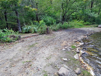 My intention was to bypass he falls on the way out and visit them on the way back. I had brought my GPS unit even though we had done the hike before as I wanted to see how long and how fast we would go. We started our hike by turning on the electronic collar on Sheena and the remote in my pocket. When I let Sheena out of the car she started running around the parking area sniffing everything in sight. At 12:15 AM we started our hike by walking down the woods road toward the bridge across Russell Brook. The road was completely dry. I did not know at the time that these conditions would continue through the entire hike.! As we crossed the bridge, I could see that the water in the brook very low and almost not flowing. The Japanese knotweed was in full nloom and was we continued we found it encroaching on the trail with only a narrow path. I used to cut back the knotweed but it is the responsibility of the DEC and they seldom bother. We bypassed the trail to the falls and continued on the main trail toward Trout Pond. The history of this area is very interesting. Russell Brook Falls had been the site of a dam that impounded water for a waterwheel in Butternut Grove. The wheel was still there a few years ago. The area near the register box was the "landing zone" for loggers who cleared the evergreen trees, not for tanning but, for the production of wood alcohol. The trees were transported on narrow gauge railway that ran parallel to Russell Brook. The railway met the mainline O&W near Butternut Grove where the logs were unloaded. There were several acid factories in the area that produced wood alcohol. There was also a factory on the lower part of Russell Brook that produced khaki dye for the uniforms of American troops during World War I. We followed the main trail passed the register box and up the trail toward Trout Pond. The trail was dry which was a contrast to many times when it has been wet and muddy. I did notice that several blowdowns had been cut and cleared from the trail using a chainsaw. These trails are maintained by the DEC and the frequency that they are maintained is spotty.
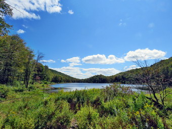 We continued on the trail uphill toward Trout Pond. I wasn't consciously pushing the pace but the walk seemed to go very quickly as we passed the path to the first primitive campsite on the left. My breathing and heartrate were up but it felt good. Sheena was leading the way but keeping a consistent distance ahead of me. She did come back to visit several times! I could hear the outlet stream from Trout Pond but the sound was niffled. Sheena was ahead of me on the trail with an occasional trip off trail. Giving her the command "Trail" brought here right back. When she is on the trail, she picks a certain distance ahead of me and maintains that distance by waiting for me or speeding up. I did notice that all the small streams that cross the trail were completely dry. Soon we were at the outlet end of the pond and we walked over to the shore.I put my pack down to get out my camera and while I was doing that I heard splashing as Sheena was doing some wading in the water. The skies were blue with towering puffy white clouds. The sun was shining but would not interfere with photography. What was most remarkable was the level of water in the pond. There was at least 10 feet between the spillway and the water leaving an extra wide beach area. Of course, this meant there was no water going over the dam. I could see some trees around the edge of the lake were starting to change to yellows and reds. I made sure to get shots of the pond and the blue sky with the clouds. I also some of the beach and the empty spillway. In the process I also included the more colorful trees. I remembered times when I was there with Sheila and she would swim to retrieve sticks or wade to cool off. I packed up and we returned to the main trail to walk the flat woods road toward the inlet end of the pond. This trail is always wet but on this day it was dry! Sheena kept walking over to the edge of the water looking like she might jump in again. We did walk off the trail to the shore where I took a few more pictures from different angles. The small stream just before the trail junction near the leanto was also dry. When we came to the bridge, I stopped to take a few pictures of the pond from the bridge. The inlet stream was dry without a drop of water. This was so unusual I took a few shots. Sheena was doing zoomies around the trails and paths. We crossed the bridge and stayed to the right on the Mud Pond Trail which would take us over Cherry Ridge and form a loop back to the parking area. The trail was uncharacteristicly dry but very rocky as we started to ascend the hill. My left leg foot was a little sore as this route is the most difficult I have done in some time. As we continued up the trail, I slowed a little as the grade increased. I had not been hiking many hills much over the summer and I felt it. We began to run into places where branches, small trees, and large trees had been cut and removed from the trail. These trails are maintained by the DEC so they must have had a crew in the area recently.
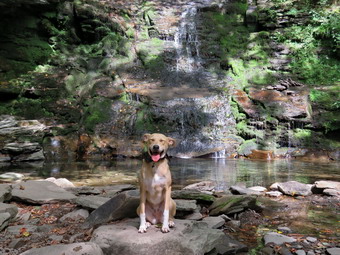 From the bridge at the inlet we climbed 430 feet over the next .75 miles. The trail headed west from the inlet until turning sharply south at around 2 miles. The highest point on the trail was at 2.2 miles after which most of the rest of the hike is downhill. I was not surprised that I was getting tired on the climb but I still felt great. As we started down the other side, the trail was still dry even in places where it is usually damp. There was none of the standing or running water which I have come to expect. The relatively dry conditions continued for the rest of the trip making the hike more enjoyable than some of the last outings here. The pain in my left foot unproved so I hardly felt it. We ascended a small hill to the stand of small birch trees and then descended the other side. At 3.4 miles we had descended 420 feet from Cherry Ridge to the snowmobile trail near Mud Pond. I could see that the trail was dry so we stayed on the woods road. O considered walking over to Mud Pond but I was a little later than I wanted and the sun was at the wrong angle. We ascended a small hill before starting downhill back toward the parking area. Usually this section has some running water across it and some running down the trail. Today there was no water in any of the streams except for the small stream near the bottom of the hill which had a trichle. This part of the trail is exceptionally rocky making the descent tricky. Even though I was being careful there were times I was very glad I had the poles! All told, we dropped another 380 feet over the next .7 miles back to the bridge just before the trail register. I crossed the bridge over the outlet stream which had some water but it was not flowing. We continued on the trail to the first junction where we turned right. When we came to the path to the falls we turned left and walked toward the falls. Someone had trimmed the knotweed back along this path. We walked to the spot where the path descends to the streambed. We walked down to the bottom and to the streambed. I was glad there were no people present. The falls had barely any water falling over the rocks. The volume was about what a garden hose would supply! I put down my pack and got out my camera and took some pictures of the falls at different angles and zooms. I also took shots of the stream which had only a small amount of water flowing. I remembered how Sheila would pose in front of the falls while I took pictures of her. I got Sheena to pose briefly by the falls and took a few shots. I returned to my pack and put away the camera. We walked back up to the path that runs out to the main trail.
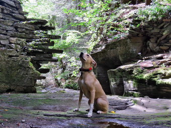 We turned right and and headed up the hill because I wanted to see the upper falls. Once we reached the top I had to decide if I wanted to go down to the streambed again. I decided I would but Sheena was way ahead of me and had already jumped own and headed for the stream. I sat on a ledge of rock and lowered myself down then followed the path to the streambed. Although the area was dry, some of the rocks had some damp moss which was slippery. I put my pack down and got out my camera. The upper falls were as dry or drier than the larger, lower falls. I was able to get almost to the middle of the stream to take pictures. I took shots of the interior of the ravine and the stream and dam. I was able to walk across the stream to the other side to take some pictures from places and angles I had never used. I had Sheena sit near the brink of the falls so that I could take some shots. When I was done, I put away the camera and started up the path. I wondered where Sheena was but found she had already jumped up the ledge to the top. I threw my poles up and grabbed on to a root. I pulled myself up but either the ledge is higher or I am older! As we started back I had Sheena walk close to me as there was a lot of broken glass on the trail! I will never understand why people can't have fun and cleanup after themselves without being inconsiderate of others. We walked down the path and straight out to the trail. I paused for a moment to take a few final pictures of the knotweed. We crossed the bridge and walked up the trail to the parking area. We were back at the car at 3:05 PM and had hiked 4.7 miles in 2 hours and 50 minutes with an elevation gain of 925 feet. We had stopped 25 minutes for pictures. My moving speed was just under 2 mph but I was satisfied because of the rolling terrain. There were now no cars in the lot and we had met no other hikers on the trail. We did meet one car coming down the road on the way out. The driver pulled into a pulloff which I appreciated.
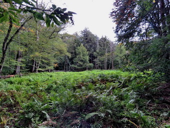
![]()
![]()
![]()
![]()
![]() On Friday, September 5th, I was ready to get out and hike for the fifth day in a row. None of the previous hikes were long but they were getting me in the habit of hiking rather than sitting at home. I had ambulance coverage until noon and thought about getting out by 8:00 AM for a longer hike somewhere close. My crew covered a call at 6:15 AM but when the pager sounded at 8:00 AM no EMT responded. I did respond but was disappointed that I would now be on call for the rest of the day!. When we returned I called another EMT and they agreed to cover call starting at 2:00 PM. I thanked them and was very happy we could get out even if it was a shorter hike. The rain that was in the forecast was now out of the forecast so I asked Cindy if she would like to go to Frick Pond and hike the Logger's Loop. She said "Yes' and we started to get ready at 1:30 PM when the temperature was 76 on the back porch. As I started gathering my equipment and getting dressed, Sheena was very quiet but did not let me out of her sight. I got dressed in a new Columbia long-sleeved shirt without a baselayer. I put on a pair of RailRiders hiking pants which are expensive but last a long time and have features like deep pockets and a generous cut which I really like. I decided to put on my Keen Durand hiking boots which fit well. I added a new pair of Xstance insoles in an effort to find the best support and cushioning for my feet. These insoles have shock absorbing gel pads, TPU arch support, and memory foam cushioning all wrapped in a breathable fabric. The insoles have been hyped by their manufacturer and seemed to be living up to their claims. I grabbed a pair of Leki Makalu Lite poles I have been using for some time because they are light and lock without slipping. I decided to wear my OR BugOut gaiters as a defense against the ticks that are looking for a warm home and a meal! I put the ecollar on Sheena and turned it on. We got our gear and Sheena in my car and left Livingston Manor at 2:00 PM. I drove out the DeBruce Road about 6 miles to Mongaup Road and turned left to continue up the road to the point where it splits. I stayed left on Beech Mountain Road and drove to the Frick Pond trailhead. When we arrived at the parking areas, there was one cars parked in the smaller lot. I pulled into the smaller lot and parked. The skies were completely bright and blue and there were a few clouds.
On Friday, September 5th, I was ready to get out and hike for the fifth day in a row. None of the previous hikes were long but they were getting me in the habit of hiking rather than sitting at home. I had ambulance coverage until noon and thought about getting out by 8:00 AM for a longer hike somewhere close. My crew covered a call at 6:15 AM but when the pager sounded at 8:00 AM no EMT responded. I did respond but was disappointed that I would now be on call for the rest of the day!. When we returned I called another EMT and they agreed to cover call starting at 2:00 PM. I thanked them and was very happy we could get out even if it was a shorter hike. The rain that was in the forecast was now out of the forecast so I asked Cindy if she would like to go to Frick Pond and hike the Logger's Loop. She said "Yes' and we started to get ready at 1:30 PM when the temperature was 76 on the back porch. As I started gathering my equipment and getting dressed, Sheena was very quiet but did not let me out of her sight. I got dressed in a new Columbia long-sleeved shirt without a baselayer. I put on a pair of RailRiders hiking pants which are expensive but last a long time and have features like deep pockets and a generous cut which I really like. I decided to put on my Keen Durand hiking boots which fit well. I added a new pair of Xstance insoles in an effort to find the best support and cushioning for my feet. These insoles have shock absorbing gel pads, TPU arch support, and memory foam cushioning all wrapped in a breathable fabric. The insoles have been hyped by their manufacturer and seemed to be living up to their claims. I grabbed a pair of Leki Makalu Lite poles I have been using for some time because they are light and lock without slipping. I decided to wear my OR BugOut gaiters as a defense against the ticks that are looking for a warm home and a meal! I put the ecollar on Sheena and turned it on. We got our gear and Sheena in my car and left Livingston Manor at 2:00 PM. I drove out the DeBruce Road about 6 miles to Mongaup Road and turned left to continue up the road to the point where it splits. I stayed left on Beech Mountain Road and drove to the Frick Pond trailhead. When we arrived at the parking areas, there was one cars parked in the smaller lot. I pulled into the smaller lot and parked. The skies were completely bright and blue and there were a few clouds.
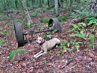 I set my GPS unit and we started out the woods road to the Quick Lake Trail at the register. The trail was dry with only the hint of some moisture on the grass. From the register on the trail was damp on places with isolated patches of mud. There was no standing water or running water across the trail. It was easy to avoid the mud by picking our steps carefully. As we walked we could see the tracks of a small pickup truck which I had seen there before. The local rangers were unaware of any "official" work being done but I would like to know who is putting ruts on the trail and disturbing the dam at the bridge in Frick Pond. At Gravestone Junction, we stopped so that I could take some pictures of the memorial stone for two young children from the Lobbdell family who died when their cabin caught fire in the 1903's. When I was done, we turned right on the Logger's Loop Trail to do a counterclockwise loop heading toward Times Square. Almost immediately we ran into tall stands of weeds blocking the trail. I stopped to take some pictures. The NYNJTC decided to eliminate individual maintainers and trail supervisors in favor of roving trail crews. The result in this area has not been good. After a flurry of activity last summer, it is obvious that the crew had not returned to maintain the area. This is a shame as the former maintainers always tried to keep the loop around Frick Pond in good shape as so many people are introduced to hiking on these trails. I put my camera away and we wad through the weeds. On the other side it wasn't long before we came to the primitive campsites to the left of the trail and two blowdowns blocking the trail. These two trees have been across the trail for months and no one has addressed them. When individual maintainers were working on the trails they would have been gone in less than a week! I again took some shots to show the problem and then we continued toward Tomes Square. The rest of the trail was largely clear but it was wet and muddy in spots. The walk to Times Square is mostly downhill which we enjoyed. Sheena was out ahead following her nose and venturing if the trail in places. A whistle or a "Not too far' bring her right back to me every time. All of the small streams which cross the trail were dry. At Times Square we continued straight ahead on the Logger's Loop which was wet but not as bad as I have seen it in the past. There are many surface springs and some runoff that head downhill to Times Square. We started a slight uphill climb on the trail but the hiking was relatively easy. The trail flattened and we came to the small, seasonal "pond" on the right side of the trail. The pond had no water and was a field of ferns. I took some shots and noticed the ferns were growing brown and some leaves on the trees were turning. Some insects were out and biting so I put on some repellant and regretted that I had not brought my OT floppy hat that allows me to apply bug juice to it.
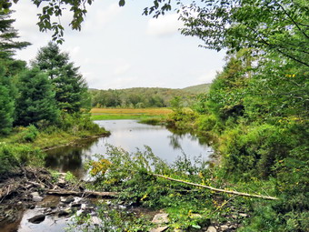 I pointed out to Sindy several large plastic culverts along the way. The DEC has started a project to replace the metal culverts and to install culverts were they were needed but did not exist. That project began at least five years ago but was not completed and the black culverts stand out like a sore thumb. The rest of the Loggers Loop to Iron Wheel Junction usually has deep ponds and large mud pits but on this day there were no ponds and only few small muddy areas. We came to a large culvert that directs a substantial stream underneath the trail. I stopped to take some shots as the stream was completely dry! We continued on the trail and it wasn't long before we were walking downhill and the climbing a small hill to Iron Wheel Junction. We stopped at the trail junction so I could take some pictures of the wheels that give the junction its name. Sheena posed for some pictures before we turned left and headed back toward Frick Pond on the Quick Lake Trail. The trail is slightly downhill which allowed us to keep up a good pace. It was made even easier as the places that are normally wet and muddy were almost dry! When we came to the small stream in the woods, we found the water level so low it was hard to see any water flowing. I took some pictures of the area before we move on. Walking through the "spruce tunnel" was easy as it too was almost dry. Eventually we walked out the other side where the trail was mostly dry with a little mud. We came to another blowdown blocking the trail. It had been there so long that hikers had created a detour around it! We continued on the trail and arrived at the junction with the Big Rock Trail where we turned right to stay on the Quick Lake Trail. We headed toward the bridge at the outlet end of Frick Pond. The trail was dry with hardly any mud. We continued on the Quick Lake Trail to the bridge across the outlet of Frick Pond. We crossed the bridge and stopped at the other side. I dropped my pack to get out the camera despite the fact that I have taken hundreds of pictures from this location. The skies were blue but it was somewhat overcast with only a few clouds.I also took shots of the pond and of Beech Mountain. I noticed a tree near the outlet had been cut and was lying in the water. I looked at the dut and could not decide whether it was manmade of beaver-made. There wee other trees that had been cut for no particular reason. To me, this is vandalism and should be addressed. I packed up and we continued up the hill and back to Gravestone Junction. This section of trail was a little damp with som mud. At Gravestone Junction we continued out the Quick Lake Trail and back to the car. We arrived at the car at 4:05 PM having hiked 3.7 miles in 1 hours and 50 minutes with an elevation gain of 340 feet. Our time stopped was 17 minutes most of which was time spent taking pictures. Our overall speed was 2 MPH while our moving speed was 2.3 MPH.
![]()
![]()
![]()
![]() On Thursday, September 4th I had not planned to hike as we had gone out three days in a row and my body ached more than a little. In addition, we had two early morning ambulance calls. I got up at 6:30 AM, made Cindy a cup of tea, let Sheena out, and went back to sleep. I woke up again at 8:00 AM to the ambulance pager sounding. We completed that call in our won district. We were back at base for only 15 minutes and were called to cover a call in Liberty. This time we got back to base and I finished my documentation. I met my wife at Caf� 43 where they on have only delicious food. I returned home to find Sheena begging to go out for a hike. I still was not convinced I wanted to hike but Sheena had other ideas and was indicating that she thought hiking was a great idea. By 1:30 PM Sheena could no longer be contained so I finally decided to listen to her which pleased her greatly! I decided to go across the street to Round Top with Sheena and hike some small loops which would keep me close for ambulance calls. I was the only EMT on duty so I would take my phone which announces calls and allows me to indicate I am responding. I started to get ready to hike at 1:30 PM with the temperature at 72 degrees on the back porch. I got dressed in a new Columbia long-sleeved shirt without a baselayer. I put on a pair of RailRiders hiking pants which are expensive but last a long time and have features like deep pockets and a generous cut which I really like. I decided to put on my Keen Durand hiking boots which fit well. I added a new pair of Xstance insoles in an effort to find the best support and cushioning for my feet. These insoles have shock absorbing gel pads, TPU arch support, and memory foam cushioning all wrapped in a breathable fabric. The insoles have been hyped by their manufacturer and seemed to be living up to their claims. I grabbed a pair of Leki Makalu Lite poles I have been using for some time because they are light and lock without slipping. I put the ecollar on Sheena and turned it on. At 1:50 PM I put Sheena on her leash and we walked out the door to start the hike. We headed down the driveway and toward the street. Sheena has gotten used to walking on her leash to the end of the drive but sometimes gets nervous as we get near the road. This time she looked both ways and then looked at me and I said "OK" because there were no cars. She readily crossed the street and headed across the field by the church. We walked to the back of the church and began the ascent of the steepest hill behind the church. Sheena had no problem walking up the hill except for the fact that she likes to stop and sniff very frequently. The hill is short but gets the circulation pumping and is the steepest and longest climb on the "trail." We did not stop on the way to the top of the hill and set a fast pace. At the top we paused for a minute so I could look around at the hills that surround the hamlet of Livingston Manor. The skies which had been blue and sunny were now overcast with dark clouds and there was a wind blowing. Sheena was eager to enter the woods on the trail and hopped right up the steps. The trail was completely dry.
On Thursday, September 4th I had not planned to hike as we had gone out three days in a row and my body ached more than a little. In addition, we had two early morning ambulance calls. I got up at 6:30 AM, made Cindy a cup of tea, let Sheena out, and went back to sleep. I woke up again at 8:00 AM to the ambulance pager sounding. We completed that call in our won district. We were back at base for only 15 minutes and were called to cover a call in Liberty. This time we got back to base and I finished my documentation. I met my wife at Caf� 43 where they on have only delicious food. I returned home to find Sheena begging to go out for a hike. I still was not convinced I wanted to hike but Sheena had other ideas and was indicating that she thought hiking was a great idea. By 1:30 PM Sheena could no longer be contained so I finally decided to listen to her which pleased her greatly! I decided to go across the street to Round Top with Sheena and hike some small loops which would keep me close for ambulance calls. I was the only EMT on duty so I would take my phone which announces calls and allows me to indicate I am responding. I started to get ready to hike at 1:30 PM with the temperature at 72 degrees on the back porch. I got dressed in a new Columbia long-sleeved shirt without a baselayer. I put on a pair of RailRiders hiking pants which are expensive but last a long time and have features like deep pockets and a generous cut which I really like. I decided to put on my Keen Durand hiking boots which fit well. I added a new pair of Xstance insoles in an effort to find the best support and cushioning for my feet. These insoles have shock absorbing gel pads, TPU arch support, and memory foam cushioning all wrapped in a breathable fabric. The insoles have been hyped by their manufacturer and seemed to be living up to their claims. I grabbed a pair of Leki Makalu Lite poles I have been using for some time because they are light and lock without slipping. I put the ecollar on Sheena and turned it on. At 1:50 PM I put Sheena on her leash and we walked out the door to start the hike. We headed down the driveway and toward the street. Sheena has gotten used to walking on her leash to the end of the drive but sometimes gets nervous as we get near the road. This time she looked both ways and then looked at me and I said "OK" because there were no cars. She readily crossed the street and headed across the field by the church. We walked to the back of the church and began the ascent of the steepest hill behind the church. Sheena had no problem walking up the hill except for the fact that she likes to stop and sniff very frequently. The hill is short but gets the circulation pumping and is the steepest and longest climb on the "trail." We did not stop on the way to the top of the hill and set a fast pace. At the top we paused for a minute so I could look around at the hills that surround the hamlet of Livingston Manor. The skies which had been blue and sunny were now overcast with dark clouds and there was a wind blowing. Sheena was eager to enter the woods on the trail and hopped right up the steps. The trail was completely dry.
As soon as we entered the woods, I took Sheena off her leash. Sheena was ranging ahead of me and taking some time to explore off the trail. At the first trail junction, we turned right and start the long gentle climb up the woods road. At the end we turned left on the trail and walked uphill to the junction with the blue trail. We turned left and walked along the base of Round Top. I again realized that I needed to bring my Stihl weed whacker to cut down the brush encroaching on the trail. At the next junction we turned left to continue on the yellow trail. We walked down a small hill and passed the "Sitting Rocks". Soon we were at the viewpoint where we followed the yellow trail as it headed downhill to the first trail junction. Sheena was showing a lot if energy by running ahead and the returning to me. She was also ranging off trail but coming right back to me. At the first trail junction we turned around and headed back up the hill.
The hike up the hill seemed easier than ever and we were soon at the top. We followed the yellow trail as it turned to the right and proceeded through the field of ferns. We passed the "Sitting Rocks" and walked up the small hill. The trail continued through some areas were there was brush hanging into the trail. At the first junction with the blue trail we turned right and followed the yellow trail along the base of Round Top. At the next junction with the blue trail we turned right to stay on the yellow trail to complete another small loop. What I could see of the skies showed changes from sunny to dark. I hoped the rain would hold off. At the end of the trail we turned right on the woods road and headed downhill toward the first trail junction. At the trail junction we turned around and started back up the woods roads.
At the end of the woods road we turned left on the trail and walked uphill to the junction with the blue trail. We turned left and walked along the base of Round Top. At the next junction we turned left to continue on the yellow trail. We walked down a small hill and passed the "Sitting Rocks". Soon we were at the viewpoint where we followed the yellow trail as it headed downhill to the first trail junction. Sheena was showing a lot if energy by running ahead and the returning to me. She was also ranging off trail but coming right back to me. At the first trail junction we turned around and headed back up the hill.
The hike up the hill still seemed easier than the long walk up the woods road and we were soon at the top. We followed the yellow trail as it turned to the right and proceeded through the field of ferns. We passed the "Sitting Rocks" and walked up the small hill. At the first junction with the blue trail we turned right and followed the yellow trail along the base of Round Top. At the next junction with the blue trail we turned right to stay on the yellow trail to complete another small loop. The skies continued to show changes from dark to sunny. The rain had held off so far. At the end of the trail we turned right on the woods road and headed downhill toward the first trail junction. At the trail junction we turned left and headed out to the trailhead. I put Sheena back on the leash as we turned right to walk down the cemetery hill to the church parking lot. We walked through the parking lot to Rock Avenue. We walked across the road after we looked both ways. We were back at the house by 3:00 PM. We hiked for 1 hour and 10 minutes for over 2 miles of hiking. The four small loops took about the same time as 2 small and 2 big loops or two figure 8s! Sheena drank a lot of water and then laid down by me for a nap.
![]()
![]()
![]()
![]() On Wednesday, September 3rd I had not planned to hike as we had gone out two days in a row and my body ached a little. In addition, we had two overnight ambulance calls. I got up at 6:30 AM, made Cindy a cup of tea, let Sheena out, and went back to sleep. I woke up again at 10:00 AM and noticed it was a little cloudy but the temperature was 72 degrees. I still was not convinced I wanted to hike but Sheena had other ideas and was indicating that she thought hiking was a great idea. I completed some chores around the house. By 1:30 PM Sheena could no longer be contained so I finally decided to listen to her which pleased her greatly! I decided to go across the street to Round Top with Sheena and hike some figure 8s. I was the only EMT on duty so I would take my phone which announces calls and allows me to indicate I am responding. I started to get ready to hike at 1:45 PM with the temperature at 78 degrees on the back porch. I got dressed in a new Columbia Omni-Shade Omni-Wick shirt without a baselayer. I put on a pair of RailRiders hiking pants which are expensive but last a long time and have features like deep pockets and a generous cut which I really like. I decided to wear a pair of low-cut and lighter no-name hiking shoes. The shoes are very light and the outsoles have an aggressive tread. Like many hiking shoes they have no arch support or cushioning in the insole. I decided I would not add an insole as I do for all my shoes because the hike would be short. I grabbed a pair of Leki Makalu Lite poles I have been using for some time because they are light and lock without slipping. I put the ecollar on Sheena and turned it on. At 2:00 PM I put Sheena on her leash and we walked out the door to start the hike. We headed down the driveway and toward the street. Sheena has gotten used to walking on her leash to the end of the drive but sometimes gets nervous as we get near the road. This time she looked both ways and then looked at me and I said "OK" because there were no cars. She readily crossed the street and headed across the field by the church. We walked to the back of the church and began the ascent of the steepest hill behind the church. Sheena had no problem walking up the hill except for the fact that she likes to stop and sniff very frequently. The hill is short but gets the circulation pumping and is the steepest and longest climb on the "trail." We did not stop on the way to the top of the hill and set a fast pace. At the top we paused for a minute so I could look around at the hills that surround the hamlet of Livingston Manor. The skies were a blue with a few clouds. Sheena was eager to enter the woods on the trail and hopped right up the steps. The trail was completely dry.
On Wednesday, September 3rd I had not planned to hike as we had gone out two days in a row and my body ached a little. In addition, we had two overnight ambulance calls. I got up at 6:30 AM, made Cindy a cup of tea, let Sheena out, and went back to sleep. I woke up again at 10:00 AM and noticed it was a little cloudy but the temperature was 72 degrees. I still was not convinced I wanted to hike but Sheena had other ideas and was indicating that she thought hiking was a great idea. I completed some chores around the house. By 1:30 PM Sheena could no longer be contained so I finally decided to listen to her which pleased her greatly! I decided to go across the street to Round Top with Sheena and hike some figure 8s. I was the only EMT on duty so I would take my phone which announces calls and allows me to indicate I am responding. I started to get ready to hike at 1:45 PM with the temperature at 78 degrees on the back porch. I got dressed in a new Columbia Omni-Shade Omni-Wick shirt without a baselayer. I put on a pair of RailRiders hiking pants which are expensive but last a long time and have features like deep pockets and a generous cut which I really like. I decided to wear a pair of low-cut and lighter no-name hiking shoes. The shoes are very light and the outsoles have an aggressive tread. Like many hiking shoes they have no arch support or cushioning in the insole. I decided I would not add an insole as I do for all my shoes because the hike would be short. I grabbed a pair of Leki Makalu Lite poles I have been using for some time because they are light and lock without slipping. I put the ecollar on Sheena and turned it on. At 2:00 PM I put Sheena on her leash and we walked out the door to start the hike. We headed down the driveway and toward the street. Sheena has gotten used to walking on her leash to the end of the drive but sometimes gets nervous as we get near the road. This time she looked both ways and then looked at me and I said "OK" because there were no cars. She readily crossed the street and headed across the field by the church. We walked to the back of the church and began the ascent of the steepest hill behind the church. Sheena had no problem walking up the hill except for the fact that she likes to stop and sniff very frequently. The hill is short but gets the circulation pumping and is the steepest and longest climb on the "trail." We did not stop on the way to the top of the hill and set a fast pace. At the top we paused for a minute so I could look around at the hills that surround the hamlet of Livingston Manor. The skies were a blue with a few clouds. Sheena was eager to enter the woods on the trail and hopped right up the steps. The trail was completely dry.
As soon as we entered the woods, I took Sheena off her leash. I looked up and saw a woman hiking out the trail toward us. She was walking slowly but I was impressed as she had a pair of Leki poles. She said she had been hiking for almost 2 hours. After she passed, we started on the trail with Sheena setting a good pace. Sheena was ranging ahead of me and taking some time to explore off the trail. At the first trail junction, Sheena chose to go straight up the hill. When we reached the top of the hill, we followed the yellow trail as it turned right. We walked uphill through the field of ferns that was full grown and still very green despite temperatures at night that dipped into the 40's. When we reached the "sitting rock", Sheena ignored it and continued to walk along the trail. We continued on the yellow trail up a small hill to the junction with the blue trail to the summit. I decided we would do a figure 8 so we turned right on the yellow trail. We followed the yellow trail along the base of Round Top with Sheena running ahead, waiting for me, and then running back. I did my best to keep up with her. At the next junction with the blue trail, we turned left and headed up toward the summit. Sheena showed no sign of slowing down as she ran up and down the trail. We passed by the white crossover trail and over the highest point on the trail on public land and started down the other side. We bypassed the white crossover trail and turned left on the switchback in the blue trail. Sheena is getting very good at making the correct turns on the figure 8 pattern that we use. We walked out into the woods and turned almost 180 degrees to head back to the main blue trail. There was one large branch lying near the ground and I took the time to break off some branches but could not remove it completely without a saw. I practiced giving Sheena commands so she will get used to obeying them. "With" makes her walk next to me near my heels. "Not too far" tells hers to wait for me until I am closer. "Come" makes her return to me and sit until I release her. On the main blue trail we turned left and headed down the main blue trail. At the junction with the yellow trail we turned left and walked along the base of Round Top. At the next junction with the blue trail we turned right and headed down the yellow trail. Where the trail meets the woods road, we turned right and continued downhill to the first trail junction. Sheena was in the lead for most of the hike and always seems to get the turns correct. The electronic collar has been working very well. Sheena had a lot of energy left so I decided to turn around and get in another figure 8.
We turned around and walked up the woods road with Sheena pushing the pace. At the end of the woods road we turned left on the yellow trail and headed up to the first junction with the blue trail. This area of the trail and a few branches and bushes that need to be trimmed before the winter season. We turned left on the yellow trail at the junction and walked along the base of Round Top to the next junction with the blue trail. Since Sheena was still interested in hiking, we turned right and headed up the blue trail toward the summit. We turned right on the switchback and headed out into the woods. We made the nearly 180 degree turn and headed back to the main blue trail. We turned right and bypassed the white crossover trail. We walked the blue trail to the summit and then started down the other side. When we came to the white trail we bypassed it and continued downhill to the junction with the yellow trail. We turned right and again walked along the base of Round Top. At the next trail junction, we turned left and headed toward the lookout. We continued downhill on the yellow trail and Sheena again bypassed the "Sitting Rocks". We walked on the yellow trail down to the viewpoint and continued to follow the trail as it turned left. Sheena still had tons of energy left and it was hard to stop her from trying to do zoomies and run off the trail into the woods. We started to descend the trail and Sheena showed she still had a lot of energy left as she continued to run ahead and then double back. I decided to let her have her fun until we got to the first trail junction. We walked straight out to the trailhead where I put her back on the leash. We turned right to walk down the cemetery hill to the church parking lot. We walked through the parking lot to Rock Avenue. We walked across the road after we looked both ways. We were back at the house by 3:00 PM. We hiked for 1 hour for over 2 miles of hiking. Sheena drank a lot of water and then laid down by me for a nap.
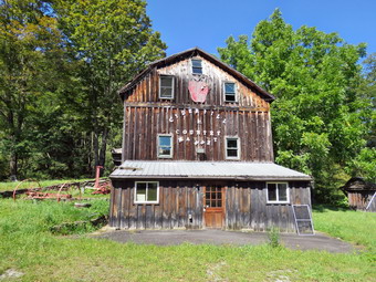
![]()
![]()
![]()
![]()
![]() On Tuesday, September 2nd I wanted to get out for a longer hike as I had ambulance coverage from 8:00 AM to 2:00 PM. There were no ambulance calls overnight but I had some intestinal distress that left me wondering whether I should hike at all. I got up and ate some breakfast and felt much better. In addition, Sheena was giving clear indications she wanted to make it two days in a row of hiking. I started to get ready to hike at 10:30 AM with with the temperature at 66 degrees and Sheena watching my every move. I decided to hike the Parksville Rail Trail from Parksville toward Livingston Manor. I got dressed in a new Columbia Omni-Shade Omni-Wick shirt without a baselayer. I put on a pair of RailRiders hiking pants which are expensive but last a long time and have features like deep pockets and a generous cut which I really like. I thought about wearing a pair of low-cut and lighter hiking shoes but thought the trail might be wet and muddy. I decided to put on my Keen Durand hiking boots which fit well. I added a new pair of Xstance insoles in an effort to find the best support and cushioning for my feet. These insoles have shock absorbing gel pads, TPU arch support, and memory foam cushioning all wrapped in a breathable fabric. The insoles have been hyped by their manufacturer and seemed to be living up to their claims. I grabbed a pair of Leki Makalu Lite poles I have been using for some time because they are light and lock without slipping. I also put on my OR BugOut gaiters for the ticks that are still active. I put the ecollar on Sheena and turned it on. At 10:45 AM I put my gear in the car and Sheena in the back seat. I headed out Old Route 17 across the Flats and then took Old Route 17 and Service Road to the point where they meet Fox Mountain Road. Just after this intersection is the western parking area for the rail trail. The parking lot was empty as I put Sheena on her leash for the short road walk to the beginning of the trail.
On Tuesday, September 2nd I wanted to get out for a longer hike as I had ambulance coverage from 8:00 AM to 2:00 PM. There were no ambulance calls overnight but I had some intestinal distress that left me wondering whether I should hike at all. I got up and ate some breakfast and felt much better. In addition, Sheena was giving clear indications she wanted to make it two days in a row of hiking. I started to get ready to hike at 10:30 AM with with the temperature at 66 degrees and Sheena watching my every move. I decided to hike the Parksville Rail Trail from Parksville toward Livingston Manor. I got dressed in a new Columbia Omni-Shade Omni-Wick shirt without a baselayer. I put on a pair of RailRiders hiking pants which are expensive but last a long time and have features like deep pockets and a generous cut which I really like. I thought about wearing a pair of low-cut and lighter hiking shoes but thought the trail might be wet and muddy. I decided to put on my Keen Durand hiking boots which fit well. I added a new pair of Xstance insoles in an effort to find the best support and cushioning for my feet. These insoles have shock absorbing gel pads, TPU arch support, and memory foam cushioning all wrapped in a breathable fabric. The insoles have been hyped by their manufacturer and seemed to be living up to their claims. I grabbed a pair of Leki Makalu Lite poles I have been using for some time because they are light and lock without slipping. I also put on my OR BugOut gaiters for the ticks that are still active. I put the ecollar on Sheena and turned it on. At 10:45 AM I put my gear in the car and Sheena in the back seat. I headed out Old Route 17 across the Flats and then took Old Route 17 and Service Road to the point where they meet Fox Mountain Road. Just after this intersection is the western parking area for the rail trail. The parking lot was empty as I put Sheena on her leash for the short road walk to the beginning of the trail.
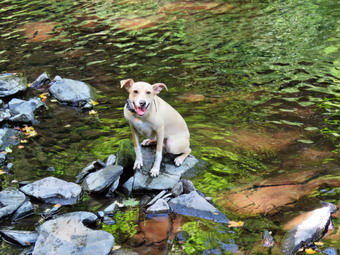 We started out at 11:00 AM with the temperature right at 68 degrees. A slight breeze was blowing but the skies were bright and sunny with some billowing white clouds. We walked on Service Road toward Fox Mountain Road and turned left to walk underneath the Quickway. We walked back to the intersection of Fox Mounatin Road and Benton Hollow Road and hopped the guard rail where I took Sheena off her leash. We immediately came to what was left of the trestle supports that carried the trail tracks over the stream. I noticed what remained of a painting on the trestle. I had seen this painting before but had not realized it was a memorial to NASCAR driver Davey Allison #28 who drove the Texaco-Havoline Ford car. Allison died in a helicopter crash in 1993. We walked up the trail to left to the top of the trestle. As we entered the shade of the trees, it immediately seemed a little cooler. The trail was well defined and stretched ahead for some distance. Like most rail trails it is very straight. Town of Liberty Supervisor Frank DeMayo had told me that this was state land and the town had an agreement from the state to use it during the summer. The hope is to connect the Parksville Rail Trail to all the sections that stretch as far as Livingston Manor. We started to walk along the trail and I noticed there was quite a bit of traffic on the Quickway but that I could shut out the noise. The land dropped off steeply to the Little Beaverkill on the right. On the left were some "cliffs" which were the result of the railroad cutting a path for the tracks. We continued to walk along the well-defined trail which was completely dry. It was a pleasant walk without many insects which surprised me. There were a few small blowdowns on the trail which could be removed with hand tools. I walked over or around these and removed some small branches on the trail as we walked. Sheena jumped over all the blowdowns. She can take a running start or seemingly jump from a standing start. There are two places along the trail where there are piles of garbage. It is hard to determine why they were there. Both piles had tarps over them which seemed to indicate someone once valued the items but people have begun to remove them. There are some very interesting signs. A VW bug was just over the bank on the right after the first pile of debris. We soon came to a gate on the trail which was odd since it was state land. No one seems to know why the gate is there or who placed it. It may separate the state land from the private land of Sonoma Falls. We walked around the gate and continued on the trail. There was a path to the left just after the gate. It looked interesting but we stayed on the rail trail.
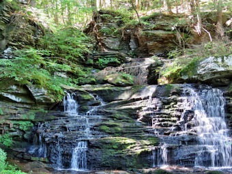 Soon we came to a small pond on the right with a red building behind it. The building looked to be in good shape but the windows were all boarded up. There was a definite path between the pond on the right and the wetlands on the left of the trail. It looked like a beaver trail to me but I could not see any dam, lodge, or even any trees that the beavers had cut. The level of the pond was very low as we had not had rain of any significance for weeks. After hiking about 1.3 miles, we came to a driveway on the left which leads to the Sonoma Falls property. I knew this was private land but two town supervisors had said it was alright to visit it. At one time there was a campground on the property. Some local business people bought the property and built a cider mill and market. They took the time to construct some hiking trails along the stream. I remember that the falls were very nice with at least five separate drops which increased in height the farther upstream one ventured. The business closed when not enough people would go out of their way to visit. It was 11:30 AM and it had only taken us 30 minutes to hike the 1.3 miles. I decided to continue to hike to Old Liberty Road. We walked along the complete flat trail wit wetlands on the right and "cliffs" on the left. These cliffs were formed by the railroad blasting a clear path for the tracks. The walk to Old Liberty Road went quickly and we were at the gate in 8 minutes. We immediately turned around and hiked back to the driveway to Sonoma Falls in 7 minutes. We turned right and walked toward the first falls behind the main building. I pt down my pack and got out the camera. The sun was very bright making the photography challenging. I walked to the front of the main building and took pictures of that building and some of the others. The roof of the main building is collapsing. Vandals have painted graffiti on other buildings. It made me very sad to see this once busy attraction deteriorate is badly. We walked back to my pack at the stream just behind the building and I got my first look at the falls. They had not changed much but the water level was very low. There was a falls right in front and one visible farther upstream. I started taking the first of what would be a large number of pictures. I perched on some rocks and got a nice shot of both sets of falls. I picked up the pack and walked a little uphill where there was a nice viewpoint and I took some more pictures. I put the camera back in the pack as we walked the trail up to the second falls and I found a way to get a clear shot. There are several areas where there is laid up stone which made me think there had been mills along the stream at some point. I again put the camera in the pack as we walked a little farther upstream to the third set of falls. The amount of water coming over the falls was minimal and the sun was very bright. I decided to skip these falls and we moved on.
We continued to walk and came to a small pond at the base of the highest falls so far. From the pond the sunlight was too bright for any good shots so we continued to walk along the stream until I found a good viewpoint for the falls. I had to experiment with zoom and angles amd settings to get some shot. I also tried using the flash which seemed to darken the pictures! I took some shots and of the lower falls and a few of the upper. We walked up the bank and then up the hill toward the upper falls. We walked as far as we could and then descended some to get better pictures of the upper falls. I again used the flash to improve some shots. When I was done, we walked back up the bank and then up the steep hill toward the uppermost falls. We walked along the edge of the gorge until I could get some shots of the last falls. This is by far the highest falls and trying to get all of it in one shot was challenging given the bright sunlight. I took a few shots and then moved a little more upstream for a better view of the upper drop of the three that make up these falls. The water level continued to be very low but the noise the falls was making was impressive. I took my last shots of the falls and then packed up to get ready to hike back to the car. We walked up to a woods road that passes over the stream. We turned left and followed the woods road in the opposite direction. We continued to the sign at the trail junction and instead of turning left to follow the trails back the way we had come, we continued straight ahead following yellow markers. The markers followed another woods road and were pretty clear until I looked ahead and could not see the anymore. I followed Sheena who seemed to be able to find the trail even when there was no trail! We passed through some muddy areas which carry the runoff from the higher ground and the water from spring to the valley below. We came to a point where another woods road turned left and also where I could find yellow markers. Sheena wanted to continue straight ahead along a woods road but I told her "Let's go down". She immediately started downbill following the woods road. The yellow markers continued for a short distance down the hill until the woods road ended at another woods road. We had the choice of going left or right. I knew that turning left would take us back to the cider mill. I said "Back to the car" and Sheena turned right. It wasn't very long before we were at the rail trail at the point near the gate. This was the trail I had thought about exploring earlier! Sheena turned right on the rail trail and I followed as we began a fast-paced walk back to the car. We were back at the car at 1:00 PM having hiked over 4 miles in 2 hours with stopped time for photography. The ascent was over 300 feet almost all of which was the climb to the waterfalls. I do hope the plans to connect the sections of the rail trails are successful! I also hope that someone reopens Sonoma Falls as it is a beautiful setting.
![]()
![]()
![]()
![]() On Monday, September 1st I had not planned to hike as I was covering ambulance calls with only one other responder. Sheena had other ideas and was indicating that she thought hiking was a great idea. I completed some chores around the house and began to get ready to hike at noon. Sheena watched my every move, snifted my clothes and sat by the door to my study so that I could not "forget" her. I decided to go across the street to Round Top with Sheena and hike some loops to change it up a little from the figure 8s we normally do. I started to get ready to hike with the temperature at 74 degrees on the back porch which was a bit warmer than the forecast. I got dressed in a new Columbia Omni-Shade Omni-Wick shirt without a baselayer. I put on a pair of RailRiders hiking pants which are expensive but last a long time and have features like deep pockets and a generous cut which I really like. I thought about wearing a pair of low-cut and lighter hiking shoes but thought the trail might be wet and muddy. I decided to put on my Keen Durand hiking boots which fit well. I added a new pair of Xstance insoles in an effort to find the best support and cushioning for my feet. These insoles have shock absorbing gel pads, TPU arch support, and memory foam cushioning all wrapped in a breathable fabric. The insoles have been hyped by their manufacturer and seemed to be living up to their claims. I grabbed a pair of Leki Makalu Lite poles I have been using for some time because they are light and lock without slipping. I put the ecollar on Sheena and turned it on. I put my cell phone in a pocket hoping I would not have to respond on a call. At 12:20 PM I put Sheena on her leash and we walked out the door to start the hike. We headed down the driveway and toward the street. Sheena has gotten used to walking on her leash to the end of the drive but sometimes gets nervous as we get near the road. This time she looked both ways and then looked at me and I said "OK" because there were no cars. She readily crossed the street and headed across the field. We walked to the back of the church and began the ascent of the steepest hill behind the church. Sheena had no problem walking up the hill except for the fact that she likes to stop and sniff very frequently. The hill is short but gets the circulation pumping and is the steepest and longest climb on the "trail." We did not stop on the way to the top of the hill and set a fast pace. Sheena is getting bigger every day and her pull on the leash is signficant. At the top we paused for a minute so I could look around at the hills that surround the hamlet of Livingston Manor. The skies were a blue with a few clouds. Sheena was eager to enter the woods on the trail and hopped right up the steps. The trail was only damp with almost no mud.
On Monday, September 1st I had not planned to hike as I was covering ambulance calls with only one other responder. Sheena had other ideas and was indicating that she thought hiking was a great idea. I completed some chores around the house and began to get ready to hike at noon. Sheena watched my every move, snifted my clothes and sat by the door to my study so that I could not "forget" her. I decided to go across the street to Round Top with Sheena and hike some loops to change it up a little from the figure 8s we normally do. I started to get ready to hike with the temperature at 74 degrees on the back porch which was a bit warmer than the forecast. I got dressed in a new Columbia Omni-Shade Omni-Wick shirt without a baselayer. I put on a pair of RailRiders hiking pants which are expensive but last a long time and have features like deep pockets and a generous cut which I really like. I thought about wearing a pair of low-cut and lighter hiking shoes but thought the trail might be wet and muddy. I decided to put on my Keen Durand hiking boots which fit well. I added a new pair of Xstance insoles in an effort to find the best support and cushioning for my feet. These insoles have shock absorbing gel pads, TPU arch support, and memory foam cushioning all wrapped in a breathable fabric. The insoles have been hyped by their manufacturer and seemed to be living up to their claims. I grabbed a pair of Leki Makalu Lite poles I have been using for some time because they are light and lock without slipping. I put the ecollar on Sheena and turned it on. I put my cell phone in a pocket hoping I would not have to respond on a call. At 12:20 PM I put Sheena on her leash and we walked out the door to start the hike. We headed down the driveway and toward the street. Sheena has gotten used to walking on her leash to the end of the drive but sometimes gets nervous as we get near the road. This time she looked both ways and then looked at me and I said "OK" because there were no cars. She readily crossed the street and headed across the field. We walked to the back of the church and began the ascent of the steepest hill behind the church. Sheena had no problem walking up the hill except for the fact that she likes to stop and sniff very frequently. The hill is short but gets the circulation pumping and is the steepest and longest climb on the "trail." We did not stop on the way to the top of the hill and set a fast pace. Sheena is getting bigger every day and her pull on the leash is signficant. At the top we paused for a minute so I could look around at the hills that surround the hamlet of Livingston Manor. The skies were a blue with a few clouds. Sheena was eager to enter the woods on the trail and hopped right up the steps. The trail was only damp with almost no mud.
As soon as we entered the woods, I took Sheena off her leash. We started on the trail with Sheena setting a good pace. Sheena was ranging ahead of me and taking some time to explore off the trail. At the first trail junction, we turned right and started up the woods road which is the gentler approach to the trails. The walk up the woods road went quickly and at the end we turned left to follow the trail up to the junction with the blue trail. Rather than turn right as we do for figure 8s, we continued straight ahead up the hill. This confused Sheena as she had already made the turn but she caught up quickly and head up the hill. We passed the white crossover trail and headed up to the highest point on public land. We walked over the top and started down the other side. We again avoided the white rail. I intended to turn left on the switchback but Sheena headed straight down the hill and I followed. At the junction with the yellow trail we continued straight ahead toward the lookout. When we came to the "Sitting Rock" Sheena passed it like it was not there. She headed out into the ferns but came right back to the trail. At the viewpoint we followed the yellow trail as it turned left and headed toward the first trail junction. The ground was dry and a little "slippery" but we were soon at the first junction. We immediately turned around and headed back up the trail to the lookout. We followed the yellow trail as it headed right and back through the field of ferns. The ferns were still very green but I knew it would not be long before they would turn brown. There were some leaves on then ground but most were brown. We continued passed the :sitting Rock" and up the small hill to the junction with the blue trial. This time we turned right and walked along the base of Round Top. The branches and brush closing in on the trail reminded me I needed to make a maintenance trip before winter when the snow on the branches would block the trail. At the next junction with the blue trail we turned right and headed down the yellow trail to the wood road. We turned right and walked the woods road back to the first rail junction.
I hoped to get in two big and two small loops and we were now half done. We turned around and walked up the woods road with Sheena pushing the pace. At the end of the woods road we turned left on the yellow trail and headed up to the first junction with the blue trail. This area of the trail and a few branches that needed to be trimmed before the winter season. We turned left on the yellow trail at the junction and walked along the base of Round Top to the next junction with the blue trail. We turned left and again walked down the yellow trail to the lookout. The trail turned left and we followed it down to the viewpoint. We followed the yellow trail as it turned left and continued down the hill to the first trail junction. Sheena was having a great time doing some zoomies and then going off trail and back. We turned around to start the last big loop. I still felt fresh and Sheena showed no signs of slowing as she ran up the hill. A turn to the right took us through the ferns one more time. We walked up the small hill again and along the narrow trail to the next trail junction with the blue trail. This time we continued straight up the hill on the blue trail. We bypassed the switchback in the blue trail and the white crossover trail and continued over the top. Sheena was in the lead as we started down the blue trail to the junction with the yellow trail. We bypassed the white trail on the right and continued straight ahead at the junction with the yellow trail. We followed the yellow trail to the woods road and then turned right to follow the woods road to the first trail junction. We had complete two of each loop so we turned left and headed out to the trailhead. Sheena showed she still had a lot of energy left as she continued to run ahead and then double back. I decided to let her have her fun until we got to the trailhead. We walked straight out to the trailhead where I put her back on the leash. We turned right to walk down the cemetery hill to the church parking lot. We walked through the parking lot to Rock Avenue and across the road after we looked both ways. We were back at the house by 1:45 PM. We hiked for 1 hour and 25 minutes for well over 2 miles of hiking. Sheena drank a lot of water and then laid down by me for a nap.
![]()
![]()
![]()
![]() On Thursday, August 28th I had not planned to hike as we had gone out two days in a row and my body ached a little. Sheena had other ideas and was indicating that she thought hiking was a great idea. I completed some chores around the house even though I had ambulance coverage only until 2:00 PM. At 12:30 PM I finally decided to listen to Sheena which pleased het greatly! I decided to go across the street to Round Top with Sheena and hike some figure 8s. I started to get ready to hike with the temperature at 68 degrees on the back porch. I got dressed in a new Columbia Omni-Shade Omni-Wick shirt without a baselayer. I put on a pair of RailRiders hiking pants which are expensive but last a long time and have features like deep pockets and a generous cut which I really like. I thought about wearing a pair of low-cut and lighter hiking shoes but thought the trail might be wet and muddy. I decided to put on my Keen Durand hiking boots which fit well. I added a new pair of Xstance insoles in an effort to find the best support and cushioning for my feet. These insoles have shock absorbing gel pads, TPU arch support, and memory foam cushioning all wrapped in a breathable fabric. The insoles have been hyped by their manufacturer and seemed to be living up to their claims. I grabbed a pair of Leki Makalu Lite poles I have been using for some time because they are light and lock without slipping. I grabbed my OR floppy hat and but left home my OR Bugout gaiters. I put the ecollar on Sheena and turned it on. At 1:00 PM I put Sheena on her leash and we walked out the door to start the hike. We headed down the driveway and toward the street. Sheena has gotten used to walking on her leash to the end of the drive but sometimes gets nervous as we get near the road. This time she looked both ways and then looked at me and I said "OK" because there were no cars. She readily crossed the street and headed across the field. We walked to the back of the church and began the ascent of the steepest hill behind the church. Sheena had no problem walking up the hill except for the fact that she likes to stop and sniff very frequently. The hill is short but gets the circulation pumping and is the steepest and longest climb on the "trail." We did not stop on the way to the top of the hill and set a fast pace. Sheena is getting bigger every day and her pull on the leash is signficant. At the top we paused for a minute so I could look around at the hills that surround the hamlet of Livingston Manor. The skies were a blue with a few clouds. Sheena was eager to enter the woods on the trail and hopped right up the steps. The trail was only damp with almost no mud.
On Thursday, August 28th I had not planned to hike as we had gone out two days in a row and my body ached a little. Sheena had other ideas and was indicating that she thought hiking was a great idea. I completed some chores around the house even though I had ambulance coverage only until 2:00 PM. At 12:30 PM I finally decided to listen to Sheena which pleased het greatly! I decided to go across the street to Round Top with Sheena and hike some figure 8s. I started to get ready to hike with the temperature at 68 degrees on the back porch. I got dressed in a new Columbia Omni-Shade Omni-Wick shirt without a baselayer. I put on a pair of RailRiders hiking pants which are expensive but last a long time and have features like deep pockets and a generous cut which I really like. I thought about wearing a pair of low-cut and lighter hiking shoes but thought the trail might be wet and muddy. I decided to put on my Keen Durand hiking boots which fit well. I added a new pair of Xstance insoles in an effort to find the best support and cushioning for my feet. These insoles have shock absorbing gel pads, TPU arch support, and memory foam cushioning all wrapped in a breathable fabric. The insoles have been hyped by their manufacturer and seemed to be living up to their claims. I grabbed a pair of Leki Makalu Lite poles I have been using for some time because they are light and lock without slipping. I grabbed my OR floppy hat and but left home my OR Bugout gaiters. I put the ecollar on Sheena and turned it on. At 1:00 PM I put Sheena on her leash and we walked out the door to start the hike. We headed down the driveway and toward the street. Sheena has gotten used to walking on her leash to the end of the drive but sometimes gets nervous as we get near the road. This time she looked both ways and then looked at me and I said "OK" because there were no cars. She readily crossed the street and headed across the field. We walked to the back of the church and began the ascent of the steepest hill behind the church. Sheena had no problem walking up the hill except for the fact that she likes to stop and sniff very frequently. The hill is short but gets the circulation pumping and is the steepest and longest climb on the "trail." We did not stop on the way to the top of the hill and set a fast pace. Sheena is getting bigger every day and her pull on the leash is signficant. At the top we paused for a minute so I could look around at the hills that surround the hamlet of Livingston Manor. The skies were a blue with a few clouds. Sheena was eager to enter the woods on the trail and hopped right up the steps. The trail was only damp with almost no mud.
As soon as we entered the woods, I took Sheena off her leash. We started on the trail with Sheena setting a good pace. Sheena was ranging ahead of me and taking some time to explore off the trail. At the first trail junction, we continued straight up the hill with Sheena leading the way. When we reached the top of the hill, we followed the yellow trail as it turned right. We walked uphill through the field of ferns that was full grown and still very green despite temperatures at night that dipped into the 40's. When we reached the "sitting rock", Sheena ignored it and continued to walk along the trail. We continued on the yellow trail up a small hill to the junction with the blue trail to the summit. I decided we would do a figure 8 so we turned right on the yellow trail. We followed the yellow trail along the base of Round Top with Sheena running ahead, waiting for me, and then running back. I did my best to keep up with her. At the next junction with the blue trail, we turned left and headed up toward the summit. Sheena showed no sign of slowing down as she ran up and down the trail. We passed by the white crossover trail and over the highest point on the trail on public land and started down the other side. We bypassed the white crossover trail again and turned left on the switchback in the blue trail. Sheena is getting very good at making the correct turns on the figure 8 pattern that we use. We walked out into the woods and turned almost 180 degrees to head back to the main blue trail. There was one large branch hanging into the trail and I took the time to break off some branches but could not remove it completely without a saw. I practiced giving Sheena commands so she will get used to obeying them. "With" makes her walk next to me near my heels. "Not too far" tells hers to wait for me until I am closer. "Come" makes her return to me and sit until I release her. On the main blue trail we turned left and headed down the main blue trail. At the junction with the yellow trail we turned left and walked along the base of Round Top. At the next junction with the blue trail we turned right and headed down the yellow trail. Where the trail meets the woods road, we turned right and continued downhill to the first trail junction. Sheena was in the lead for most of the hike and always seems to get the turns correct. The electronic collar has been working very well. Sheena had a lot of energy left so I decided to turn around and get in another figure 8 starting at 1:35 PM.
We turned around and walked up the woods road with Sheena pushing the pace. At the end of the woods road we turned left on the yellow trail and headed up to the first junction with the blue trail. This area of the trail and a few others need to be trimmed before the winter season. We turned left on the yellow trail at the junction and walked along the base of Round Top to the next junction with the blue trail. Since Sheena was still interested in hiking, we turned right and headed up the blue trail toward the summit. We turned right on the switchback and headed out into the woods. We made the nearly 180 degree turn and headed back to the main blue trail. We turned right and bypassed the white crossover trail. We walked the blue trail to the summit and then started down the other side. When we came to the white trail we bypassed it and continued downhill to the junction with the yellow trail. We turned right and again walked along the base of Round Top. At the next trail junction, we turned left and headed toward the lookout. At this point I heard sirens that sounded as if the ambulance was responding to a call. I was proud that I had a good crew that could respond and give me a chance to hike. We continued downhill on the yellow trail and Sheena again bypassed the "Sitting Rocks". We walked on the yellow trail down to the viewpoint and continued to follow the trail as it turned left. Sheena still had tons of energy left and it was hard to stop her from trying to do zoomies and run off the trail into the woods. We started to descend the trail and Sheena showed she still had a lot of energy left as she continued to run ahead and then double back. I decided to let her have her fun until we got to the first trail junction. We walked straight out to the trailhead where I put her back on the leash. We turned right to walk down the cemetery hill to the church parking lot. We walked through the parking lot to Rock Avenue. We walked across the road after we looked both ways. We were back at the house by 2:05 PM. We hiked for 1 hour and 5 minutes for over 2 miles of hiking. Sheena drank a lot of water and then laid down by me for a nap.
![]()
![]()
![]()
![]()
![]() On Thursday, August 21st, I had full ambulance coverage from 6:00 AM to 2:00 PM and wanted to get in a longer hike with Sheena. I had plans to do an 8+ mile hike and had no overnight calls. However, at 6:30 AM a call came in and my coverage did not respond so I went instead. I was home by 8:30 AM already having abandoned my plans for a longer hike. Cindy and I went for breakfast at Caf� 43 in town and then did some errands around town. We were home again by 10:00 AM and I got some chores done around the house. At 10:45 I asked Cindy If she would like to hike the Parksville Rail Trail and she said "Yes". There was a small chance of rain but the temperature was 70 degrees and the conditions were ideal for hiking. The Parksville Rail Trail is close to home but has an interesting waterfall. It is under three miles out and back but keeping a quick pace helps increase the difficulty. Sheena actually does get in about twice the mileage that we do as she forges ahead and then comes back! I have transitioned from using a leash all the time to using a GarmimSport PRO electronic collar which has many versatile settings and seems to do the job. This allows Sheena to roam and keeps me sane by not having to yank on her leash. It seems that Sheena likes hiking as she smells my clothes and then runs to sit by the door! I got dressed in a new Columbia Omni-Shade Omni-Wick shirt without a baselayer. I put on a pair of RailRiders hiking pants which are expensive but last a long time and have features like deep pockets and a generous cut which I really like. I thought about wearing a pair of low-cut and lighter hiking shoes but thought the trail might be wet and muddy. I decided to put on my Keen Durand hiking boots which fit well. I added a new pair of Xstance insoles in an effort to find the best support and cushioning for my feet. These insoles have shock absorbing gel pads, TPU arch support, and memory foam cushioning all wrapped in a breathable fabric. The insoles have been hyped by their manufacturer and seemed to be living up to their claims. I grabbed a pair of Leki Makalu Lite poles I have been using for some time because they are light and lock without slipping. I grabbed my OR floppy hat and but left home my OR Bugout gaiters. We quickly put together Cindy's new PacerPoles that I got her for her birthday as the other were unsuitable for use. We put our gear in the back of the car and Sheena in the back seat and we left Livingston Manor at 11:00 AM. I drove out Old Route 17 toward Parksville and turned left under the Quickway overpass onto Service Road. I drove toward Parksville and pulled into the parking area on the right side of the road just after Fox Mountain Rd. There were no cars in the lot as we parked with the temperature at 62 degrees I made sure Sheena's ecollar was adjusted correctly and turned on. I put her on her leash and let her out of the car at 11:15 AM.
On Thursday, August 21st, I had full ambulance coverage from 6:00 AM to 2:00 PM and wanted to get in a longer hike with Sheena. I had plans to do an 8+ mile hike and had no overnight calls. However, at 6:30 AM a call came in and my coverage did not respond so I went instead. I was home by 8:30 AM already having abandoned my plans for a longer hike. Cindy and I went for breakfast at Caf� 43 in town and then did some errands around town. We were home again by 10:00 AM and I got some chores done around the house. At 10:45 I asked Cindy If she would like to hike the Parksville Rail Trail and she said "Yes". There was a small chance of rain but the temperature was 70 degrees and the conditions were ideal for hiking. The Parksville Rail Trail is close to home but has an interesting waterfall. It is under three miles out and back but keeping a quick pace helps increase the difficulty. Sheena actually does get in about twice the mileage that we do as she forges ahead and then comes back! I have transitioned from using a leash all the time to using a GarmimSport PRO electronic collar which has many versatile settings and seems to do the job. This allows Sheena to roam and keeps me sane by not having to yank on her leash. It seems that Sheena likes hiking as she smells my clothes and then runs to sit by the door! I got dressed in a new Columbia Omni-Shade Omni-Wick shirt without a baselayer. I put on a pair of RailRiders hiking pants which are expensive but last a long time and have features like deep pockets and a generous cut which I really like. I thought about wearing a pair of low-cut and lighter hiking shoes but thought the trail might be wet and muddy. I decided to put on my Keen Durand hiking boots which fit well. I added a new pair of Xstance insoles in an effort to find the best support and cushioning for my feet. These insoles have shock absorbing gel pads, TPU arch support, and memory foam cushioning all wrapped in a breathable fabric. The insoles have been hyped by their manufacturer and seemed to be living up to their claims. I grabbed a pair of Leki Makalu Lite poles I have been using for some time because they are light and lock without slipping. I grabbed my OR floppy hat and but left home my OR Bugout gaiters. We quickly put together Cindy's new PacerPoles that I got her for her birthday as the other were unsuitable for use. We put our gear in the back of the car and Sheena in the back seat and we left Livingston Manor at 11:00 AM. I drove out Old Route 17 toward Parksville and turned left under the Quickway overpass onto Service Road. I drove toward Parksville and pulled into the parking area on the right side of the road just after Fox Mountain Rd. There were no cars in the lot as we parked with the temperature at 62 degrees I made sure Sheena's ecollar was adjusted correctly and turned on. I put her on her leash and let her out of the car at 11:15 AM.
The first part of the trail before the trees was damp as the sun had evaporated the rains that had fallen yesterday and overnight. I let Sheena off her leash and she ran ahead and then came back toward us. Off her leash Sheena runs ahead of us a certain distance and then maintains that distance by waiting or increasing her pace. We were soon under the cover of the trees and Cindy amd I both agreed it felt cooler but still pleasant. Once we were hiking on the trail, we were sheltered from the sun but I was still warm. The trail was wet with soft and muddy patches in all the usual spots. The trail runs parallel to the Little Beaverkill and the new section of State Route 17. It follows the route of the O&W railroad and is very flat. Sheena was setting a quick pace and I didn't mind as long as she would listen and wait for us when necessary. We continued on the trail and I noticed the water level in the stream was much lower than on the previous trip last week. We continued on the trail through some muddy patches until we came to the viewpoint just before the wooden walkways. This spot has a nice view down to the stream and the skies were blue with some clouds. The problem is the viewpoint is partially blocked by trees and bushes so I decided not to stop for pictures. We walked across the wooden walkways which were wet and slippery. The area before the bridge was only damp. Just after the bridge was a patch of mud from one side of the trail to the other. The culvert under the bridge appeared permanently blocked and the water forms the mud. No one seems concerned about solving this problem. We walked around the mud to continue the hike but Sheena walked right through it. We came to the landslide that had brought down several trees that had been cut and cleared. This area is now muddy but there were some stepping stones. Sheena does not seem to mind sloshing through the water and wading through the mud. As we walked, we could hear the increase in noise from the stream.
When we reached the falls, I looked at the falls and the water level was lower than last time and I almost decided to skip the pictures and just hike. I relented and Sheena and I walked down Te makeshift path to the streambed. I took off my pack and took out the camera. It was obvious that the water level was lower and there was much more bedrock visible beneath the water. I took pictures of the entire scene and of the individual parts. I used different zooms and angles and even was able to step out to the middle of the stream on some rocks. Back on shore I took shots downstream and then some of Sheena posing sitting on some rocks with the falls in the background. Sheena has gotten good at posing and often does so before I ask. When I was done, we walked back up the path. I again got out the camera to take pictures of the falls from above. I also took some shots upstream. When done, I replaced the camera in my pack and started up the trail. We stopped near a bench where a path leads down to the stream. I inspected the area and found I could probably walk along the edge of the stream to the falls. I decided against this idea as the rocks were covered in moss and looked very slippery. I noticed that someone had left some white sheets of plastic on the rocks on the opposite shore. This is another example of a beautiful scene spoiled by lazy and inconsiderate people! We continued on the trail toward Parksville and within a few minutes we were nearing the Parksville end of the trail. Sheena was eager to continue even when we came to a spot in the trail where we could see the other side. The large dog that is often there was absent. We continued toward Parksville where the dogs near the end of the trail were making a lot of noise. As we approached the end of the trail, we saw a large group of young men from one of the camps approaching. It was 12:00 PM when we turned around and immediately started back toward the car at a rapid pace. We knew these young men set a fast pace and we wanted to stay ahead of them. We came to the falls and continued our quick pace with Sheena in the lead. At some point I noticed Cindy was not next to me. She had not said anything but had fallen back. I also noticed that the group of young men was no longer following us. I assumed the group had stopped at the falls and we did not see them again. Sheena began to run up and down the trail and work off her energy ignoring the fact that she was running through water and mud. She took advantage of the freedom and ran an extra-long distance before turning around and roaring back passed us. When we came to the bridge, we hopped around the mud while Sheena pushed through. We arrived back at the car at 12:30 PM after hiking over 2.7 miles in 1 hour and 30 minutes with time spent for photography. The temperature at the car was only 64 degrees. There had been no ambulance calls.
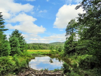
![]()
![]()
![]()
![]()
![]() On Tuesday, December 22nd, I planned to take a longer hike as I had ambulance coverage from 8:00 AM to 2:00 PM. The pager woke me at 6:30 AM for al call. As we were returning from the hospital we were asked to cover another call in Liberty further delaying my hiking plans. At 10:30 AM the temperature was 64 degrees and the skies were blue with white puffy clouds. I checked the forecast and the rain that was forecast was not until evening. I decided to go to the Frick Pond area and hike a loop that included a long uphill on the Flynn Trail. I got dressed in my new Columbia OmniShade long-sleeved crew top that reflects the sun and is surprisingly cool. I put on a pair of RailRiders hiking pants which are expensive but last along time and have features like deep pockets and a generous cut which I really like. The pants have Velcro closures at the ankles but I decided to add a pair of OR Bugout gaiters. I have not seen as many ticks as in the past but I know they are out there. I decided to put on my Keen Durand hiking boots which fit well. I added a new pair of Xstance insoles in an effort to find the best support and cushioning for my feet. These insoles have shock absorbing gel pads, TPU arch support, and memory foam cushioning all wrapped in a breathable fabric. The insoles have been hyped by their manufacturer and seemed to be living up to their claims. I grabbed a pair of Leki Makalu Lite poles I have been using for some time because they are light and lock without slipping. I also put on my OR floppy hat which allows me to spray on some insect repellant to keep away the bugs prevalent at Frick Pond. As I was getting ready Sheena was sniffing my clothes and keeping her eyes on me all the time. I got my gear in the car and Sheena in the backseat. I started out the DeBruce Road at 11:00 AM and turned left after six miles on Mongaup Pond Road. At the split in the road I stayed to the left on Beech Mountain Road following another car up to the parking areas. When we arrived, there was one car in the smaller lot and one in the larger. There were some people milling around the other car and they eventually started out the Quick Lake Trail. I parked in the smaller lot and set my GPS. I shouldered my pack as we crossed the road to start the hike at 11:15 AM.
On Tuesday, December 22nd, I planned to take a longer hike as I had ambulance coverage from 8:00 AM to 2:00 PM. The pager woke me at 6:30 AM for al call. As we were returning from the hospital we were asked to cover another call in Liberty further delaying my hiking plans. At 10:30 AM the temperature was 64 degrees and the skies were blue with white puffy clouds. I checked the forecast and the rain that was forecast was not until evening. I decided to go to the Frick Pond area and hike a loop that included a long uphill on the Flynn Trail. I got dressed in my new Columbia OmniShade long-sleeved crew top that reflects the sun and is surprisingly cool. I put on a pair of RailRiders hiking pants which are expensive but last along time and have features like deep pockets and a generous cut which I really like. The pants have Velcro closures at the ankles but I decided to add a pair of OR Bugout gaiters. I have not seen as many ticks as in the past but I know they are out there. I decided to put on my Keen Durand hiking boots which fit well. I added a new pair of Xstance insoles in an effort to find the best support and cushioning for my feet. These insoles have shock absorbing gel pads, TPU arch support, and memory foam cushioning all wrapped in a breathable fabric. The insoles have been hyped by their manufacturer and seemed to be living up to their claims. I grabbed a pair of Leki Makalu Lite poles I have been using for some time because they are light and lock without slipping. I also put on my OR floppy hat which allows me to spray on some insect repellant to keep away the bugs prevalent at Frick Pond. As I was getting ready Sheena was sniffing my clothes and keeping her eyes on me all the time. I got my gear in the car and Sheena in the backseat. I started out the DeBruce Road at 11:00 AM and turned left after six miles on Mongaup Pond Road. At the split in the road I stayed to the left on Beech Mountain Road following another car up to the parking areas. When we arrived, there was one car in the smaller lot and one in the larger. There were some people milling around the other car and they eventually started out the Quick Lake Trail. I parked in the smaller lot and set my GPS. I shouldered my pack as we crossed the road to start the hike at 11:15 AM.
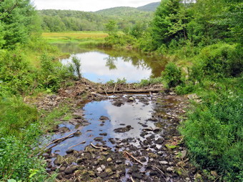 We had to be careful of the extreme erosion at the start of the Flynn Trail. After that, the walk through the woods was relatively easy. All the trees that had been lying across the trail had been removed. At the end of the trail, we turned right onto what once was Beech Mountain Road to the Beech Mountain Boy Scout Camp near Hodge Pond. There was a single, narrow track leading up the trail. The weather was warm but there was a cool breeze making the conditions almost ideal. As we walked up the trail, the skies were blue with interesting cloud patterns. Sheena was ranging far ahead and then coming back to me. I felt energized and was setting a fast pace. I decided I would not take pictures and just hike as fast as I could. We continued up the hill passing the clearing on the right side of the trail just after 1 mile. The Flynn Trail dipped briefly before climbing the last .6 miles to the junction with the Big Rock Trail. The walk had taken less than 45 minutes which was a record for us! We turned left to descend the Big Rock Trail. I was happy to be going downhill except for a little twinge in my right foot. Walking down the Big Rock Trail seemed very easy except for the fact that there are several places where it looks like the end of the descent at Times Square. The Big Rock Trail has several spots where the trail levels some and bends to the right. These spots sometimes fool me into thinking we are near to Times Square when we are not. There was one tree across the trail but it was not blocking our path. On this day I was lost in my thoughts and the walk went quickly. At 12:25 PM we had hiked 2.8 miles and the 1 mile trip down The Big Rock Trail had taken less than 30 minutes. We stood at Times Square where the Big Rock Trail and Logger's Loop cross. I decided that since I was feeling fresh, we would turn right and hike the Logger's Loop to the Quick Lake Trail at Iron Wheel Junction.
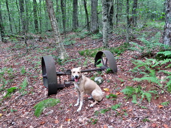 As we began on the Logger's Loop, we started up the hill with the skies growing darker and I wondered if the rain would come early. The trail heads northwest and gains about 200 feet in .8 miles where it turns southwest. Along the way I noticed the beauty of the high rocks and small cliffs on the right side of the trail. From the highest point on the trail we began to descend slightly to Iron Wheel Junction at 4.1 miles at 12:55 PM. We turned left to follow the Quick Lake Trail toward Frick Pond. This part of the trail was a little damp from some overnight showers. We walked downhill to the small stream in the woods and found it was almost dry and even drier than a week before. I stepped across the stream but Sheena just ran through. We walked through the "spruce tunnel" where many of the blowdowns had been cleared. The walk went quickly and we were soon at the junction with the Big Rock Trail. Along the way there was one blowdown that blocked the trail but we followed the detour hikers had made. The maintenance of these trails has been very poor this season as individual maintainers have been put aside for Trail Crews that seldom visit the area. We stayed to the right on the Quick Lake Trail and walked to the bridge at the outlet of Frick Pond. I stopped for a few minutes to take in the sight. Each time I pass this way I seem to be attracted to the beauty of the scene. Someone had laid down some branches to dam the water and it had worked as some ducks were swimming on the pond. The clouds had unified and formed a dark wall but there was sun shining through. We crossed the bridge and walked to the top of the hill. We walked toward Gravestone Junction where we stayed to the right on the Quick Lake Trail. We looked ahead and saw at least 20 people walking toward us. I pulled Sheena off the trail to let the party pass. One young man was wearing a tux and a young woman had on a wedding dress. I wished them well and hoped they could get in their ceremony before the rain started. The trail ahead was almost dry with a few wet spots. We continued along the Quick Lake Trail passing the register box to walk the last few hundred feet to the car. It was 1:35 PM and we had hiked 5.5 miles in 2 hours and 20 minutes with an elevation gain of 850 feet. The temperature was still only 62 degrees. I had just enough time to get home to cover ambulance calls.
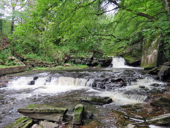
![]()
![]()
![]()
![]()
![]() On Thursday, August 21st, I had full ambulance coverage from 8:00 AM to 2:00 PM and wanted to get in a longer hike with Sheena. I had plans to do an8+ mile hike but two calls in the middle on night meant I had only two hours of sleep. When I got back at 5:00 AM, I went back to sleep and decided I would have to do a shorter walk. I woke up at 10:00 AM feeling reasonably rested. It was already 70 degrees and I decided to wait until Cindy got home from Bible study to hike the Parksville Rail Trail. The Parksville Rail Trail is close to home but has an interesting waterfall. It is under three miles out and back but keeping a quick pace helps increase the difficulty. Sheena actually does get in about twice the mileage that we do as she forges ahead and then comes back! I have transitioned from using a leash all the time to using a GarmimSport PRO electronic collar which has many versatile settings and seems to do the job. This allows Sheena to roam and keeps me sane by not having to yank on her leash. It seems that Sheena likes hiking as she smells my clothes and then runs to sit by the door! Cindy Got home at 12:15 PM and we both grabbed a quick lunch as time was growing short. I got dressed in a new Columbia Omni-Shade Omni-Wick shirt without a baselayer. I put on a pair of RailRiders hiking pants which are expensive but last a long time and have features like deep pockets and a generous cut which I really like. I thought about wearing a pair of low-cut and lighter hiking shoes but thought the trail might be wet and muddy. I decided to put on my Keen Durand hiking boots which fit well. I added a new pair of Xstance insoles in an effort to find the best support and cushioning for my feet. These insoles have shock absorbing gel pads, TPU arch support, and memory foam cushioning all wrapped in a breathable fabric. The insoles have been hyped by their manufacturer and seemed to be living up to their claims. I grabbed a pair of Leki Makalu Lite poles I have been using for some time because they are light and lock without slipping. I grabbed my OR floppy hat and pt on my OR Bugout gaiters as I expected some mud from the rain that fell all day on Wednesday. We put our gear in the back of the car and Sheena in the back seat and we left Livingston Manor at 11:40 AM. Sheena has finally realized that she can easily jump in the back seat! I drove out Old Route 17 toward Parksville and turned left under the Quickway overpass onto Service Road. I drove toward Parksville and pulled into the parking area on the right side of the road just after Fox Mountain Rd. There were no cars in the lot as we parked with the temperature at 72 degrees I made sure Sheena's ecollar was adjusted correctly and turned on. I put her on her leash and let her out of the car at 12:56 PM.
On Thursday, August 21st, I had full ambulance coverage from 8:00 AM to 2:00 PM and wanted to get in a longer hike with Sheena. I had plans to do an8+ mile hike but two calls in the middle on night meant I had only two hours of sleep. When I got back at 5:00 AM, I went back to sleep and decided I would have to do a shorter walk. I woke up at 10:00 AM feeling reasonably rested. It was already 70 degrees and I decided to wait until Cindy got home from Bible study to hike the Parksville Rail Trail. The Parksville Rail Trail is close to home but has an interesting waterfall. It is under three miles out and back but keeping a quick pace helps increase the difficulty. Sheena actually does get in about twice the mileage that we do as she forges ahead and then comes back! I have transitioned from using a leash all the time to using a GarmimSport PRO electronic collar which has many versatile settings and seems to do the job. This allows Sheena to roam and keeps me sane by not having to yank on her leash. It seems that Sheena likes hiking as she smells my clothes and then runs to sit by the door! Cindy Got home at 12:15 PM and we both grabbed a quick lunch as time was growing short. I got dressed in a new Columbia Omni-Shade Omni-Wick shirt without a baselayer. I put on a pair of RailRiders hiking pants which are expensive but last a long time and have features like deep pockets and a generous cut which I really like. I thought about wearing a pair of low-cut and lighter hiking shoes but thought the trail might be wet and muddy. I decided to put on my Keen Durand hiking boots which fit well. I added a new pair of Xstance insoles in an effort to find the best support and cushioning for my feet. These insoles have shock absorbing gel pads, TPU arch support, and memory foam cushioning all wrapped in a breathable fabric. The insoles have been hyped by their manufacturer and seemed to be living up to their claims. I grabbed a pair of Leki Makalu Lite poles I have been using for some time because they are light and lock without slipping. I grabbed my OR floppy hat and pt on my OR Bugout gaiters as I expected some mud from the rain that fell all day on Wednesday. We put our gear in the back of the car and Sheena in the back seat and we left Livingston Manor at 11:40 AM. Sheena has finally realized that she can easily jump in the back seat! I drove out Old Route 17 toward Parksville and turned left under the Quickway overpass onto Service Road. I drove toward Parksville and pulled into the parking area on the right side of the road just after Fox Mountain Rd. There were no cars in the lot as we parked with the temperature at 72 degrees I made sure Sheena's ecollar was adjusted correctly and turned on. I put her on her leash and let her out of the car at 12:56 PM.
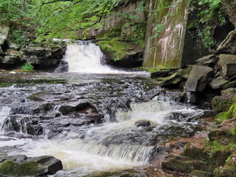 The first part of the trail before the trees was damp as the sun had evaporated the rains that had fallen yesterday. I let Sheena off her leash and she ran ahead and then came back toward us. Off her leash Sheena runs ahead of us a certain distance and then maintains that distance by waiting or increasing her pace. We were soon under the cover of the trees and Cindy amd I both agreed it felt cooler. Once we were hiking on the trail, we were sheltered from the sun but I was still warm. The trail was wet with soft and muddy patches in all the usual spots. The trail runs parallel to the Little Beaverkill and the new section of State Route 17. It follows the route of the O&W railroad and is very flat. Sheena was setting a quick pace and I didn't mind as long as she would listen and wait for us when necessary. At one point we looked up and saw a trail runner coming toward us. I took Sheena to the side of the trail so that he could pass. We continued on the trail and I noticed the water level in the stream was only a little high than on the previous trip. We continued on the trail through some muddy patches until we came to the viewpoint just before the wooden walkways. This spot has a nice view down to the stream and the skies were bright and sunny with some clouds. The problem is the viewpoint is partially blocked by trees and bushes so I decided not to stop for pictures. We walked across the wooden walkways which were wet and slippery. The area before the bridge was only damp. Just after the bridge was a patch of mud from one side of the trail to the other. The culvert under the bridge appeared permanently blocked and the water forms the mud. No one seems concerned about solving this problem. I walked around the mud to continue the hike but Sheena walked right through it. We came to the landslide that had brought down several trees that had been cut and cleared. This area is now muddy but there were some stepping stones. Sheena does not seem to mind sloshing through the water and wading through the mud. We looked up to see two women walking toward us with a noisey little dog off leash. I put Sheena on her leash and one woman picked up their dog as we passed by each other. As we walked, we could hear the increase in noise from the stream.
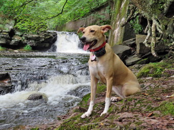 When we reached the falls, I looked at the falls and the water level was slightly higher than last time so I decided to skip the pictures and just hike. Within a few minutes, we were nearing the Parksville end of the trail and Sheena was eager to continue. We came to a spot in the trail where we could see the other side. The large dog that is often there was absent. We continued toward Parksville where the dogs near the end of the trail that had been absent during cold weather were making a lot of noise. We tagged the end of the trail when we reached the sign at the Parksville end of the rail trail. It was 1:30 PM when we turned around and immediately started back toward the car. We set a fast pace back which was interrupted as I walkd Sheena to the side of the trail to let the runner pass on his way back to his car. From the falls we set a quick pace with Sheena in the lead. We met the women with their dog but they walked off the trail and allowed us to pass. After passing them, Sheena began to run up and down the trail and work off her energy ignoring the fact that she was running through water and mud. She took advantage of the freedom and ran an extra-long distance before turning around and roaring back passed us. When we came to the bridge, we hopped around the mud while Sheena pushed through. We arrived back at the car at 2:00 PM after hiking over 2.7 miles in 1 hour and 5 minutes. The temperature at the car was 74 degrees. There had been one ambulance call which my crew covered. I go on over 80% of the calls so it feels strange when I am not on a call. I am happy that younger people are stepping up to cover calls!
![]()
![]()
![]()
![]()
![]() On Tuesday, August 19th I planned to hike a longer loop at Bear Spring WMA as I had ambulance coverage from 8:00 AM to 2:00 PM. The pager woke me for a special announcement at 7:00 AM! The temperature was 48 degrees and the skies were completely overcast. I checked the forecast and it had changed from mostly sunny to cloudy. I got Cindy a cup of tea and went back to bed! When I woke up again at 9:00 AM feeling more rested. The temperature was 66 degrees and the skies, contrary to the forecast, were now partly sunny with billowing white clouds. I decided to go to the Frick Pond area and hike a loop that included a long uphill. I got dressed in my new Columbia OmniShade long-sleeved crew top that reflects the sun and is surprisingly cool. I put on a pair of RailRiders hiking pants which are expensive but last along time and have features like deep pockets and a generous cut which I really like. The pants have Velcro closures at the ankles but I decided to add a pair of OR Bugout gaiters. I have not seen as many ticks as in the past but I know they are out there. I decided to put on my Keen Durand hiking boots which fit well. I added a new pair of Xstance insoles in an effort to find the best support and cushioning for my feet. These insoles have shock absorbing gel pads, TPU arch support, and memory foam cushioning all wrapped in a breathable fabric. The insoles have been hyped by their manufacturer and seemed to be living up to their claims. I grabbed a pair of Leki Makalu Lite poles I have been using for some time because they are light and lock without slipping. I also put on my OR floppy hat which allows me to spray on some insect repellant to keep away the bugs prevalent at Frick Pond. I got my gear in the car and Sheena in the backseat. I started out the DeBruce Road at 10:30 AM and turned left after six miles on Mongaup Pond Road. At the split in the road I stayed to the left on Beech Mountain Road following another car up to the parking areas. When we arrived, there were no cars in the smaller lots but several parked in the large lo with some people milling around. I parked in the smaller lot and immediately got ready to get ahead of the people gathering in the other lot. I set my GPS and we walked out the woods road toward Frick Pond at 10:45 AM.
On Tuesday, August 19th I planned to hike a longer loop at Bear Spring WMA as I had ambulance coverage from 8:00 AM to 2:00 PM. The pager woke me for a special announcement at 7:00 AM! The temperature was 48 degrees and the skies were completely overcast. I checked the forecast and it had changed from mostly sunny to cloudy. I got Cindy a cup of tea and went back to bed! When I woke up again at 9:00 AM feeling more rested. The temperature was 66 degrees and the skies, contrary to the forecast, were now partly sunny with billowing white clouds. I decided to go to the Frick Pond area and hike a loop that included a long uphill. I got dressed in my new Columbia OmniShade long-sleeved crew top that reflects the sun and is surprisingly cool. I put on a pair of RailRiders hiking pants which are expensive but last along time and have features like deep pockets and a generous cut which I really like. The pants have Velcro closures at the ankles but I decided to add a pair of OR Bugout gaiters. I have not seen as many ticks as in the past but I know they are out there. I decided to put on my Keen Durand hiking boots which fit well. I added a new pair of Xstance insoles in an effort to find the best support and cushioning for my feet. These insoles have shock absorbing gel pads, TPU arch support, and memory foam cushioning all wrapped in a breathable fabric. The insoles have been hyped by their manufacturer and seemed to be living up to their claims. I grabbed a pair of Leki Makalu Lite poles I have been using for some time because they are light and lock without slipping. I also put on my OR floppy hat which allows me to spray on some insect repellant to keep away the bugs prevalent at Frick Pond. I got my gear in the car and Sheena in the backseat. I started out the DeBruce Road at 10:30 AM and turned left after six miles on Mongaup Pond Road. At the split in the road I stayed to the left on Beech Mountain Road following another car up to the parking areas. When we arrived, there were no cars in the smaller lots but several parked in the large lo with some people milling around. I parked in the smaller lot and immediately got ready to get ahead of the people gathering in the other lot. I set my GPS and we walked out the woods road toward Frick Pond at 10:45 AM.
The first part of the trail was dry and these conditions continued for most of the hike. The woods road out to Frick Pond continued to be dry with no visible water or mud. As we approached Gravestone Junction, we could see another hiker ahead of us. They slowed to read the signs and I lost track of them. We stayed left at Graveyard Junction to stay on the Quick Lake Trail and we never saw the hiker that had been ahead of us. I had been noticing the tracks of a pickup truck which I had seen on our last trip. As we walked toward the bridge there were a few damp spots that stopped just short of mud. When we arrived at the bridge across the outlet, I decided to stop and take pictures despite the fact that I have hundreds from this location. The water level in the pond was so low there was no water in the stream below the bridge. The yellow caution tape was gone. There appeared to be a beaver dam forming nut I looked at the end of the branches and their placement. The ends looked like they had been cut by a hatchet and then just placed on the "dam". Beavers carefully anchor what they cut a weave it into the dam. All of this was very curious especially since the local rangers were unaware of what was happening. There was a very blue sky with some white clouds. I took some shots of the pond and the sky. We continued on around the pond staying left at the Big Rock Trail junction on the Quick Lake Trail. The trail was dry and stayed that way. There were two blowdowns on this short section of trail. One was on the ground and easy to step over. The other blowdown was much larger and blocked the trail. Hikers had detoured the trail around the tree. Ever since the NYNJTC decided to maintain the trails in this area with an "elite" trail crew rather than individual maintainers, the conditions on the trails have deteriorated. We continued on our hike passing through the "Spruce Tunnel". The small stream through the woods was reduced to a small pool with only a trickle of water flowing. Sheena simply waled across but I stopped to take some shots before using stepping stones to cross. The trail to Iron Wheel Junction is usually muddy but it too was dry. By 11:30 AM we had walked the 1.5 miles to Iron Wheel Junction. We stopped so that I could take a few pictures and Sheena walked right over to pose for some shots. We turned right and headed out on the Logger's Loop Trail which was almost completely dry.
The Logger's Loop is mostly downhill in this direction and we made good time but occasionally encountered some small blowdowns along the way. The Logger's Loop really isn't a loop by itself but starts north, turns east and eventually heads south towards Times Square. It continues straight through Times Square and ends at Gravestone Junction. Our walk went quickly as I was lost in some thoughts that now escape me. Sheena had been doing what she always does which is to go ahead a certain distance. She keeps that distance by waiting for me or quickening her pace. She often dumps excess energy by doing zoomies running farther ahead and then barreling back toward me. We continued to walk and just before starting the descent to Times Square we came to the area that is sometimes a pond and sometimes a wetland on the left side of the trail. This pond is seasonal but has been growing in size for several years. I stopped to take a few pictures as the pond was completely dry and was more a field of ferns. The area where I was standing had obviously dried. As I was standing there, the mosquitoes began to swarm and I quickly packed up to leave. We started to walk downhill toward Times Square arriving at 12:05 PM about 2.7 miles into the hike. The area was dry when it is usually wet because it is at the bottom of two hills. I had to make a decision about the next part of the hike. Straight ahead or right were the short and flat way back to the car. A left turn would add miles to the hike and start with a nice uphill! We turned left to walk uphill on the Big Rock Trail. The Big Rock Trail gains 600 feet to the Flynn Trail over 1.1 miles for an average grade of 12%. However, the route has three different climbs and can seem long at times.
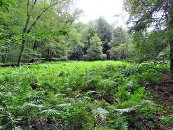 We set a pretty fast pace on the climb and I found that although my heart rate was elevated I felt much better than when we started the hike. We encountered two blowdowns on the trail that would need tools to be cleared. In the middle of the final climb, I stopped, not because I was tired, because I wanted to. I leaned on my poles and closed my eyes. The only sounds I could hear was the wind blowing through the trees and the birds chirping softly. I don't normally stop like this but it was so very peaceful. We reached the Flynn Trail at 12:45 PM after hiking 3.8 miles and stopped for a drink. Sheena took a long drink and I ate a bar. After a short break, we turned right and began the descent back to the car. I was glad to be hiking downhill but Sheena did not seem to care. She was still excited at this point and was running up the trail and back to me. She was taking a few excursions off the trail to follow animal tracks but was pretty close so I let her explore. At one point she ran off the trail like a shot chasing, I believe, some deer. I called her and said "Trail" and she came back immediately! The trip down the Flynn Trail went very quickly and we were soon at a huge evergreen tree that Cindy and I had once cleared from the trail. We arrived at the gate that blocks Beech Mountain Road and turned left to stay on the Flynn Trail. The trail through the woods avoids the private property around the cabin. Some hikers cannot read the signs and have annoyed the property owner by trespassing! We continued down to the parking area on the trail. We were back at 1:25 PM having covered 5.5 miles in 2 hours and 40 minutes with a vertical gain of 875 feet. There were now 2 more cars parked in the small parking area but none in the large area. The temperature was now 74 degrees. When we arrived home, Cindy alerted me that there was an ambulance call that needed an EMT. I changed into a corps short and left to go on the call.
![]()
![]()
![]()
![]()
![]() On Thursday, August 14th, I had full ambulance coverage from 8:00 AM to 2:00 PM and wanted to get in a longer hike with Sheena and Brad, my son-in-law. Brad and I had a call in the middle of the night and we did not get back until 2:00 AM. Another call awoke us before 6:00 AM and we returned home just before 8:00 AM. We were both very and decided to get a few more hours of sleep. I did not know if I cloud go back to sleep but I woke up at 11:00 AM feeling reasonably rested. It was already 80 degrees as I began to get ready at 11:30 AM but I new it would be cooler in the shade. I planned take Sheena for a longer hike away from Livingston Manor and decided to go to the Parksville Rail Trail as it is close but interesting with a nice falls. I asked Brad if he would like to go with us and he agreed. The Parksville Rail Trail is under three miles out and back but keeping a quick pace helps increase the difficulty. Sheena actually does get in about twice the mileage that we do as she forges ahead and then comes back! I have transitioned from using a leash all the time to using a GarmimSport PRO electronic collar which has many versatile settings and seems to do the job. This allows Sheena to roam and keeps me sane by not having to yank on her leash. It seems that Sheena likes hiking as she smells my clothes and then runs to sit by the door! I got dressed in a new Columbia Omni-Shade Omni-Wick shirt without a baselayer. I put on a pair of RailRiders hiking pants which are expensive but last a long time and have features like deep pockets and a generous cut which I really like. I thought about wearing a pair of low-cut and lighter hiking shoes but thought the trail might be wet and muddy. I decided to put on my Keen Durand hiking boots which fit well. I added a new pair of Xstance insoles in an effort to find the best support and cushioning for my feet. These insoles have shock absorbing gel pads, TPU arch support, and memory foam cushioning all wrapped in a breathable fabric. The insoles have been hyped by their manufacturer and seemed to be living up to their claims. I grabbed a pair of Leki Makalu Lite poles I have been using for some time because they are light and lock without slipping. I grabbed my OR floppy hat but left the OR Bugout gaiters behind. I decided to take my pack as I thought I might want to take pictures and the thought of having a drink and a snack was appealing. I put our gear in the back of the car and Sheena in the back seat and we left Livingston Manor at 11:50 AM. Sheena has finally realized that she can easily jump in the back seat! I drove out Old Route 17 toward Parksville and turned left under the Quickway overpass onto Service Road. I drove toward Parksville and pulled into the parking area on the right side of the road just after Fox Mountain Rd. A forest ranger's truck was in the parking area parked next to a DEC Econ police truck. Both vehicles were occupied and I wondered if something was happening. There were no cars parked in the lot when we arrived. I made sure Sheena's ecollar was adjusted correctly and turned on. I put her on her leash and let her out of the car at 12:05 PM. The temperature was 83 degrees but the sun made it feel warmer.
On Thursday, August 14th, I had full ambulance coverage from 8:00 AM to 2:00 PM and wanted to get in a longer hike with Sheena and Brad, my son-in-law. Brad and I had a call in the middle of the night and we did not get back until 2:00 AM. Another call awoke us before 6:00 AM and we returned home just before 8:00 AM. We were both very and decided to get a few more hours of sleep. I did not know if I cloud go back to sleep but I woke up at 11:00 AM feeling reasonably rested. It was already 80 degrees as I began to get ready at 11:30 AM but I new it would be cooler in the shade. I planned take Sheena for a longer hike away from Livingston Manor and decided to go to the Parksville Rail Trail as it is close but interesting with a nice falls. I asked Brad if he would like to go with us and he agreed. The Parksville Rail Trail is under three miles out and back but keeping a quick pace helps increase the difficulty. Sheena actually does get in about twice the mileage that we do as she forges ahead and then comes back! I have transitioned from using a leash all the time to using a GarmimSport PRO electronic collar which has many versatile settings and seems to do the job. This allows Sheena to roam and keeps me sane by not having to yank on her leash. It seems that Sheena likes hiking as she smells my clothes and then runs to sit by the door! I got dressed in a new Columbia Omni-Shade Omni-Wick shirt without a baselayer. I put on a pair of RailRiders hiking pants which are expensive but last a long time and have features like deep pockets and a generous cut which I really like. I thought about wearing a pair of low-cut and lighter hiking shoes but thought the trail might be wet and muddy. I decided to put on my Keen Durand hiking boots which fit well. I added a new pair of Xstance insoles in an effort to find the best support and cushioning for my feet. These insoles have shock absorbing gel pads, TPU arch support, and memory foam cushioning all wrapped in a breathable fabric. The insoles have been hyped by their manufacturer and seemed to be living up to their claims. I grabbed a pair of Leki Makalu Lite poles I have been using for some time because they are light and lock without slipping. I grabbed my OR floppy hat but left the OR Bugout gaiters behind. I decided to take my pack as I thought I might want to take pictures and the thought of having a drink and a snack was appealing. I put our gear in the back of the car and Sheena in the back seat and we left Livingston Manor at 11:50 AM. Sheena has finally realized that she can easily jump in the back seat! I drove out Old Route 17 toward Parksville and turned left under the Quickway overpass onto Service Road. I drove toward Parksville and pulled into the parking area on the right side of the road just after Fox Mountain Rd. A forest ranger's truck was in the parking area parked next to a DEC Econ police truck. Both vehicles were occupied and I wondered if something was happening. There were no cars parked in the lot when we arrived. I made sure Sheena's ecollar was adjusted correctly and turned on. I put her on her leash and let her out of the car at 12:05 PM. The temperature was 83 degrees but the sun made it feel warmer.
The first part of the trail before the trees was barely damp as the sun had evaporated the rains that had fallen several days ago. I let Sheena off her leash and she ran ahead and then came back toward us. Off her leash Sheena runs ahead of us a certain distance and then maintains that distance by waiting or increasing her pace. We were soon under the cover of the trees and Brad amd I both agreed it felt cooler. Once we were hiking on the trail, we were sheltered from the sun but I was still warm. The trail was wet with soft and muddy patches in all the usual spots. The trail runs parallel to the Little Beaverkill and the new section of State Route 17. It follows the route of the O&W railroad and is very flat. Sheena was setting a quick pace and I didn't mind as long as she would listen and wait for us when necessary. Brad and I started a conversation which centered around fire and ambulance matters. We continued on the trail and I noticed the water level in the stream was lower than on my previous trip. We continued on the trail through some muddy patches until we came to the viewpoint just before the wooden walkways. This spot has a nice view down to the stream and the skies were bright and sunny with some clouds. The problem is the viewpoint is partially blocked by trees and bushes so I decided not to stop for pictures. We walked across the wooden walkways which were damp and slippery. The area before the bridge was only damp. Just after the bridge was a patch of mud from one side of the trail to the other. The culvert under the bridge appeared permanently blocked and the water forms the mud. No one seems concerned about solving this problem. I walked around the mud to continue the hike but Sheena walked right through it. We came to the landslide that had brought down several trees that had been cut and cleared. This area is now muddy but there were some stepping stones. Sheena does not seem to mind sloshing through the water and wading through the mud. As we walked, we could hear the increase in noise from the stream. We reached the falls and I could see a large family group with children further up the trail.
I looked at the falls and the water level was lower than last time so I decided to skip the pictures and just hike. I thought we might hike part of the trail toward Livingston Manor if we got back to the car in time. I put Sheena on her leash as we pushed on toward the other end of the trail toward Parksville. The family group was walking toward us and we passed them as several of the children said "That's a cute dog!" When we had left them behind, I let Sheena of the leash but almost immediately had to hook her up again as a woman with a black lab came hiking toward us. Sheena and the other dog seemed interested in each other but we walked on by. Within a few minutes, we were nearing the Parksville end of the trail and Sheena was eager to continue. We came to a spot in the trail where we could see the other side. The large dog that is often there was absent. We continued toward Parksville where the dogs near the end of the trail that had been absent during cold weather were making some a lot of noise. We tagged the end of the trail when we reached the sign at the Parksville end of the rail trail. We immediately turned around and started back toward the car. We set a fast pace back which was interrupted as I put Sheena back on her leash to get by the family who had turned around at the falls and were returning. From the falls we set a wick pace with Sheena in the lead. We met the woman with the dog as we crossed the washed out area from the landslide. After passing them, I let Sheena off her leash again so she could run up and down the trail and work off her energy. She took advantage and ran an extra-long distance before turning around ad roaring back passed us. When we came to the bridge, we hopped around the mud while Sheena pushed through. We arrived back at the car at 1:10 PM after hiking over 2.7 miles in 1 hour and 5 minutes. The temperature at the car was 85 degrees. The forest ranger's truck was gone but the Econ Police vehicle was still present.
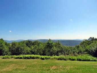
![]()
![]()
![]()
![]()
![]() On Tuesday, August 12th, I wanted to get in a longer hike than I had been doing recently. I knew my son-in-law Brad would want to accompany me and I was glad as we have many of the same interests I had coverage for ambulance calls from 8:00 AM to 2:00 PM so we could hike for up to 4 hours without guilt. When I got up at 9:00 AM it was already 70 degrees on the back porch amd I knew the temperature was forecast to rise throughput the day. I wanted to get out and hike to some elevation to test my fitness as I had not been hiking much lately. I decided to head to the Frick Pond area and hike the Flynn Trail toward Beech Mountain where there are several good viewpoints. I started to get ready at 9:45 AM with the skies blue with some puffy white clouds. Sheena was pretty excited as I started to get ready as getting out to hike is her favorite thing. I got dressed in my new Columbia Omni-shade short-sleeved crew top with no baselayer due to the expected heat. I put on a pair of RailRiders hiking pants which are expensive but last a long time and have features like deep pockets and a generous cut which I really like. I decided to put on my Keen Durand hiking boots which fit well. I added a new pair of Xstance insoles in an effort to find the best support and cushioning for my feet. These insoles have shock absorbing gel pads, TPU arch support, and memory foam cushioning all wrapped in a breathable fabric. The insoles have been hyped by their manufacturer and seemed to be living up to their claims. I grabbed a pair of Leki Makalu Lite poles I have been using for some time because they are light and lock without slipping. I put on my OR BugOut gaiters as I knew there were always ticks around that like to hitch a ride. I also wore my OR floppy hat as shade from the sun and a place to sprat insect repellent. I put my gear in the back of the car and Sheena in the back seat and left my house at 10:05 AM. I drove out the DeBruce Road about 6 miles to Mongaup Road and turned left. I continued up the road to the point where it splits and stayed left on Beech Mountain Road. It was a short drive to the parking areas on the left. The larger parking areas had one vehicle in it. I parked in the smaller lot where there was one car. I regretted that I had forgotten my GPS but I had done the hike that I intended before. We crossed the road at 10:25 AM to begin our hike on the Flynn Trail with the temperature at 74 degrees.
On Tuesday, August 12th, I wanted to get in a longer hike than I had been doing recently. I knew my son-in-law Brad would want to accompany me and I was glad as we have many of the same interests I had coverage for ambulance calls from 8:00 AM to 2:00 PM so we could hike for up to 4 hours without guilt. When I got up at 9:00 AM it was already 70 degrees on the back porch amd I knew the temperature was forecast to rise throughput the day. I wanted to get out and hike to some elevation to test my fitness as I had not been hiking much lately. I decided to head to the Frick Pond area and hike the Flynn Trail toward Beech Mountain where there are several good viewpoints. I started to get ready at 9:45 AM with the skies blue with some puffy white clouds. Sheena was pretty excited as I started to get ready as getting out to hike is her favorite thing. I got dressed in my new Columbia Omni-shade short-sleeved crew top with no baselayer due to the expected heat. I put on a pair of RailRiders hiking pants which are expensive but last a long time and have features like deep pockets and a generous cut which I really like. I decided to put on my Keen Durand hiking boots which fit well. I added a new pair of Xstance insoles in an effort to find the best support and cushioning for my feet. These insoles have shock absorbing gel pads, TPU arch support, and memory foam cushioning all wrapped in a breathable fabric. The insoles have been hyped by their manufacturer and seemed to be living up to their claims. I grabbed a pair of Leki Makalu Lite poles I have been using for some time because they are light and lock without slipping. I put on my OR BugOut gaiters as I knew there were always ticks around that like to hitch a ride. I also wore my OR floppy hat as shade from the sun and a place to sprat insect repellent. I put my gear in the back of the car and Sheena in the back seat and left my house at 10:05 AM. I drove out the DeBruce Road about 6 miles to Mongaup Road and turned left. I continued up the road to the point where it splits and stayed left on Beech Mountain Road. It was a short drive to the parking areas on the left. The larger parking areas had one vehicle in it. I parked in the smaller lot where there was one car. I regretted that I had forgotten my GPS but I had done the hike that I intended before. We crossed the road at 10:25 AM to begin our hike on the Flynn Trail with the temperature at 74 degrees.
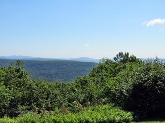 The first part of the trail near the road had become further eroded by the recent rains but people had walked around the gully forming a new trail. The walk through the woods was relatively easy and the trail was dry. When we came to the end of the trail, we turned right onto what once was Beech Mountain Road. This area of the trail was also dry, even the grass was dry. I wondered if the rest of the trail would be the same. I set a relaxed pace up the Flynn Trail and Brad and I kept up a continuous conversation which made the hike go quickly. Sheena was about 20 feet ahead of us all the time. Every timewe slowed down she did also to keep the same distance. Sometimes she would venture off the trail following a game trail or chasing a squirrel. Whenever she got too far ahead I gave the command "Not too far" and she would come right back to me. We did not stop along the way but continued toward the junction with the Big Rock Trail. The Flynn Trail is uphill all the way for the first 1.7 miles to the Big Rock Junction. We passed the mile mark around the point where there is a clearing to the right of the trail. We were soon walking the final uphill section to the junction with the Big Rock Trail. It was 11:10 AM so we had covered the 1.7 mile distance in 50 minutes which was a pretty good time. We continued through the junction and passed through the gate which is the boundary between state land and Beaverkill Land Trust property. It was a short walk to the point where the Flynn Trail heads left and downhill to Hodge Pond. Here we turned to the right on the woods road and walked along the road to the junction of some roads above the pond. At this junction a road turns left to go down to the pond. Just a little further on the road splits with the left fork passing by the site of the former Beech Mountain Boy Scout Camp and ending up on Shin Creek Road in Lew Beach. The camp has been bulldozed by the Land Trust. The road out to Shin Creek Road is now available for hiking and has a nice parking area near Shin Creek Road. There was a sign facing us that said "Parking" which made us scratch our heads. There is a grassy "field" in that direction but it looked unused. We continued up the hill toward the Hodge Pond Lookouts on a woods road that surrounds Flynn's Point on Beech Mountain, the highest point in Sullivan County. As we walked, I could see that there had not been any vehicles on the road recently as there were no new tracks and at least one blowdown across the road. I had noticed that I was a little tired walking up the Flynn Trail but felt a little more energized walking up the road. There had been some work done of the road creating runoffs so that water would run into the woods preventing erosion.
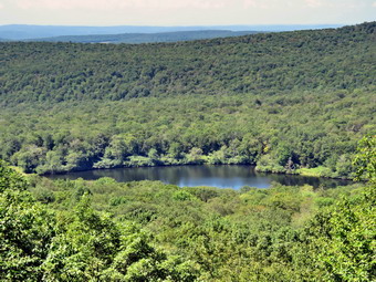 I wasn't really tired so we pushed the pace a little. When we got to the old sand and gravel pit where the trail levels the sun hit me full force and I realized how hot it really was. The trail began to gain elevation again and we passed by a spring house on the right where Sheila used to like to dig in the water and get a drink. Sheena did not seem interested in getting a drink but I encouraged her and she lapped up a little water. There are several twists and turns along this road and it is sometimes hard for me to know exactly where I am. At 2.7 miles we came to a lookout on the left of the trail. The lookout had grown in so that there was almost no view except for the tops of some hills. We did not stop but continued on the road as it made a sharp right turn. Just after this the road turned to the left and another trail branched off to the right. We followed the road to the left as it gained some elevation then started downhill. We passed a woods road on the right and then the path on the left toward Mongaup Mountain, one of the Catskill Highest Hundred. The road turned to the right and soon led to a cabin with a beautiful lawn. The lawn had an incredible view to the east with many of the 3500 foot peaks visible. The panorama from this lookout takes in the Burroughs Range and many of the other Catskill peaks. Unfortunate, the trees have begun to grow up and are starting to limit the view. The sky was flat without and distinct clouds and there was a haze hanging over the mountain peaks. I got out my camera and took some pictures despite the sun which made getting the proper exposure difficult. When I was done, I got a drink and ate a bar before continuing on the woods road. Sheena was impatient as she always wants to be in motion and she easily found the woods road and head out ahead of me. We climbed a short hill to the woods road that surrounds Beech Mountain and turned left. We followed the woods road clockwise around Beech Mountain. There are some impressive ledges on the right of the trail going in this direction. We came across a blowdown that had been cut by chainsaw. Another part of the tree had fallen across the trail and would have to be cleared. We walked around the blowdown and arrived at the Hodge Pond Lookout. I pointed out the graphic sign which indicated the danger of falling off the ledge. There is still an acceptable view from this viewpoint so I walked out to the lookout to take pictures. This lookout had been cut out giving a much better view than in the past but the trees grow rapidly. I took some pictures of the pond below and the hills in the distance. The view was still hazy in the distance. When I was done taking pictures, I had Sheena sit on the viewpoint and I tried to take some shots. The sunlit background made this difficult
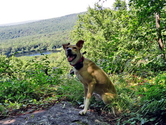 We continued on the woods road traveling clockwise around Beech Mountain. The trail was only damp in several places and the rest was dry. We were back at the road and turned left to start downhill. We definitely picked up the pace as I knew the rest of the trip back on the Flynn Trail was all flat or downhill. The trip down was much quicker than the trip up. When we reached the bottom of the hill, I thought about walking down to Hodge Pond but decided to make the hike a true out-and-back. My ambulance coverage ended at 2:00 PM and I had a meeting after that. We walked out to the Flynn Trail, turned left and were soon at the junction with the Big Rock Trail at 4.5 miles. We continued straight ahead on the Flynn Trail. The trip down the Flynn Trail can seem to take forever but on this day it went quickly. At one point we heard a noise just behind us an a boy on a mountain bike came speeding down the trail. We had no audible warning device and never said anything until he was beside us. Fortunately, Sheena listens to me on the trail and came right to me and a collision was avoided. I don't know whether this rider thought what he did was funny or if he is just not very smart! I advised him to yell out something BEFIRE he was right in top of other users on the trail. The gate came into sight sooner than I anticipated. We passed the large hemlock that Cindy and I had cut years ago. Just before the gate, we turned left on the Flynn Trail to avoid the private property around the cabin. We walked the trail back to the car arriving at 1:30 PM. There were no cars in the large lot but there was a car parked next to mine. A young lady was standing and leaning against the hood of the car. We had hiked 6.1 miles in 3 hours and 5 minutes gaining 1070 feet along the way. Our speed was not the fastest I have hiked but it was very pleasant and relaxing. The temperature had risen to 86 degrees!
![]()
![]()
![]()
![]() On Monday, August 11th I had planned to do a longer hike with Brad until my ambulance coverage collapsed. Lisa called and wanted to do a short hike on Round Top and I agreed as I wanted to get out after a weekend of family reunion and ambulance calls. We agreed to meet at the church parking lot at 8:30 AM. When I got up at 7:30 AM the temperature was 55 degrees and when I let the dog out it seemed that cool. At 8:15 AM the temperature had risen to 62 degrees as I began to get ready to hike. Sheena was with the grandkids upstairs but came barreling down the steps when she heard me say "Hike?" I knew I would have to carry my phone just in case a call came in. I got dressed in my Mammut long-sleeved crew top for a little extra warmth but did not put on a baselayer. I put on a pair of RailRiders hiking pants which are expensive but last a long time and have features like deep pockets and a generous cut which I really like. I decided to put on my Keen Durand hiking boots which fit well. I added a new pair of Xstance insoles in an effort to find the best support and cushioning for my feet. These insoles have shock absorbing gel pads, TPU arch support, and memory foam cushioning all wrapped in a breathable fabric. The insoles have been hyped by their manufacturer and seemed to be living up to their claims. I wore my OR floppy hat but left my OR Bugout gaiters behind. I grabbed a pair of Leki Makalu Lite poles I have been using for some time because they are light and lock without slipping. I put the ecollar on Sheena and turned it on. I decided not to put a harness on Sheena since she has been more well-behaved. At the last minute I got a text from Lisa indicating she would be there at 8:50 AM. I had no problem waiting but Sheena was a maniac! At 8:47 AM I put Sheena on her leash and walked out the door to start the hike. We headed down the driveway and toward the street. Sheena has gotten used to walking on her leash to the end of the drive. She also has become accustomed to waiting for cars to pass by and then crossing when I say "OK". This time she looked both ways and then looked at me but we had to wait for several cars to go by traveling at well above the residential speed limit. I finally said "OK" because there were no cars. Sheena readily crossed the street and walked along the shoulder of the road to the church parking lot where Lisa was waiting. We stopped at Lisa's car and Sheena barely said "hello" as she was so anxious to start hiking. We walked behind the church and Lisa requested we walk the middle road through the cemetery. A car was parked in the new parking area and a couple were getting out. They had a dog on a leash that was very vocal. I wanted to get passed them so we would not meet them on our hike! We made the sharp left and started up the hill to the trailhead. We did not stop on the way to the top of the hill and set a fast pace. Sheena has grown bigger than we thought she would and her pull on the leash is signficant. At the top we paused briefly to look around before Sheena turned right and entered the forest trail. I immediately let Sheena off her leash and she started on the trail. She has been good about picking a certain distance on the trail and staying that far ahead of me. She does take some side trips to follow animal trails but comes back to the main trail. Lisa and I began our non-stop conversation as we had not hike together for many months.
On Monday, August 11th I had planned to do a longer hike with Brad until my ambulance coverage collapsed. Lisa called and wanted to do a short hike on Round Top and I agreed as I wanted to get out after a weekend of family reunion and ambulance calls. We agreed to meet at the church parking lot at 8:30 AM. When I got up at 7:30 AM the temperature was 55 degrees and when I let the dog out it seemed that cool. At 8:15 AM the temperature had risen to 62 degrees as I began to get ready to hike. Sheena was with the grandkids upstairs but came barreling down the steps when she heard me say "Hike?" I knew I would have to carry my phone just in case a call came in. I got dressed in my Mammut long-sleeved crew top for a little extra warmth but did not put on a baselayer. I put on a pair of RailRiders hiking pants which are expensive but last a long time and have features like deep pockets and a generous cut which I really like. I decided to put on my Keen Durand hiking boots which fit well. I added a new pair of Xstance insoles in an effort to find the best support and cushioning for my feet. These insoles have shock absorbing gel pads, TPU arch support, and memory foam cushioning all wrapped in a breathable fabric. The insoles have been hyped by their manufacturer and seemed to be living up to their claims. I wore my OR floppy hat but left my OR Bugout gaiters behind. I grabbed a pair of Leki Makalu Lite poles I have been using for some time because they are light and lock without slipping. I put the ecollar on Sheena and turned it on. I decided not to put a harness on Sheena since she has been more well-behaved. At the last minute I got a text from Lisa indicating she would be there at 8:50 AM. I had no problem waiting but Sheena was a maniac! At 8:47 AM I put Sheena on her leash and walked out the door to start the hike. We headed down the driveway and toward the street. Sheena has gotten used to walking on her leash to the end of the drive. She also has become accustomed to waiting for cars to pass by and then crossing when I say "OK". This time she looked both ways and then looked at me but we had to wait for several cars to go by traveling at well above the residential speed limit. I finally said "OK" because there were no cars. Sheena readily crossed the street and walked along the shoulder of the road to the church parking lot where Lisa was waiting. We stopped at Lisa's car and Sheena barely said "hello" as she was so anxious to start hiking. We walked behind the church and Lisa requested we walk the middle road through the cemetery. A car was parked in the new parking area and a couple were getting out. They had a dog on a leash that was very vocal. I wanted to get passed them so we would not meet them on our hike! We made the sharp left and started up the hill to the trailhead. We did not stop on the way to the top of the hill and set a fast pace. Sheena has grown bigger than we thought she would and her pull on the leash is signficant. At the top we paused briefly to look around before Sheena turned right and entered the forest trail. I immediately let Sheena off her leash and she started on the trail. She has been good about picking a certain distance on the trail and staying that far ahead of me. She does take some side trips to follow animal trails but comes back to the main trail. Lisa and I began our non-stop conversation as we had not hike together for many months.
We started on the trail with Sheena setting a good pace. The trail had no water or mud and was only slightly damp in places. At the first trail junction, Sheena turned right on the woods road which is the more gentle approach to the trail system. At the end of the woods road, we turned left and started up the trail to the junction with the blue trail. I ask Lisa if she wanted to do a figure 8 and she agreed. We turned left on the yellow trail which was the path Sheena had chosen. We walked along the base of Round Top. Sheena was running ahead and waiting or running back to me as fast as she could. I noticed that the vegetation was growing into the trail and needed trimming. I like the bushwhack feel I get from the brush closing in but others do not and it makes snowshoeing difficult. At the next junction with the blue trail, we turned right and headed up the trail toward the summit. When we came to the switchback, Sheena turned right and we walked out into the forest. We followed the trail as it turned almost 180 degrees and headed back to the main trail. There was a small tree hanging into the trail. Someone had cut a branch and left behind a spear pointed at the unsuspecting hiker. I vowed I would get back to the trails to do some maintenance. At the main trail , we turned right and started up over the summit passing by the white crossover trail. After passing over the summit, we started down the other side. Sheena kept running ahead but only just so far before waiting for us. I found that if she did not respond to my voice she did to the beeper in the ecollar. We bypassed the white crossover trail and continued down to the junction with the yellow trail. We turned right and again walked along the base of Round Top. We continued along the yellow trail turning left and continuing downhill on the yellow trail. We descended a small hill and came to the "Sitting Rock" where Sheena jumped up and sat down momentarily. Sheena jumped down and we followed the yellow trail down to the viewpoint and turned left to follow the trail as it turned left. We followed Sheena as she rushed down the steep hill to the first trail junction. Sheena made a slight turn onto the woods road as we stood for a moment at the junction. Lisa and I concluded our long conversation. Lisa had to get to work but I had some time to do another figure 8! It was 9:37 Am and we had done our first half of the hike in 50 minutes.
When I made a move to start up the hill again, Sheena immediately ran ahead of me up the hill. We continued straight up the hill with Sheena leading the way on the trail with a few off trail excursions. Sheena was full of energy even though we had just completed a figure 8 but she only wanted to concentrate on hiking. We progressed up the hill with me following behind. Sheena decided to run up the hill ahead of me and then run back down the hill toward me. There was a lot of leaf litter on the trail and Sheena would stop and plant her feet six feet infront of me. She would then slide down the hill stopping right at my feet! This must hhave been a lot of fun because she did it several times! At the upper lookout we followed the yellow trail as it turned right. Sheena and I continued on the trail. Sheena was running off into the ferns which were over her head. She was bounding so I would see her head and sometimes her torso pop up above the ferns and then disappear. When we reached the "Sitting Rock", Sheena jumped up on it, looked around, jumped down, and continued on the trail. We continued on the yellow trail up a small hill. There were quite a few small branches on the trail and some leaning in from the side. I knew I would have to reserve some time to trim the trail and repaint the blazes. When we reached the junction with the blue trail to the summit, we turned right to walk the yellow trail along the base of Round Top on our quest for another figure 8. We continued to the junction with the blue trail. We turned left and started up the blue trail toward the summit. We walked up the trail bypassing the white crossover trail. We continued over the summit of Round Top and started down the other side. It was a pleasure hiking without Sheena on a leash as it gave me the freedom to use my poles. We again bypassed the white crossover trail on the left but almost immediately turned left on the switchback. Once again it was out to the turn in the woods and then back to the main trail. We turned left and walked downhill to the junction with the yellow trail. When we reached the junction with the yellow trail, we turned left and walked along the yellow trail at the base of Round Top. We continued on the trail to the junction with the blue trail and turned right to stay on the yellow trail. Sheena began a series of zoomies that continued for most of the rest of the hike. At the end of the trail, we turned right on the woods road and walked downhill toward the first trail junction. As I was walking, I took a closer look at the rock ledges to the right of the trail. I noticed one rather large alcove that seemed carved out of the rock. There were several other "caves" formed from splits in the rock with a another rock as the roof. I decided this was not the day to explore but thought I might return some other time. At the first junction, we turned left to head out to the trailhead. I put Sheena on her leash and we turned right as we walked down the hill behind the church. We walked out the parking lot to the road and turned right on Rock Avenue and then left into the driveway. We were back at the house by 10:12 AM. The second half of the hike took only 35 minutes! We had hiked an hour and 25 minutes covering over 2 miles.
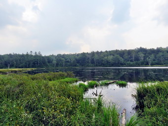
![]()
![]()
![]()
![]()
![]() On Thursday, August 7th I wanted to get out on a longer hike as I had ambulance coverage from 8:00 AM to 2:00 PM. This meant I wanted to spend time hiking not driving and preferred to go somewhere I had not been in some time. I decided to go to Long Pond as it is about 6 miles and isn't too far from my house. The temperature was 70 degrees as I was getting ready at 9:00 AM. Cindy has a women's bible study and would not be home until noon so it was just Sheena and me to hike. As I started to get ready Sheena was there to watch my every move. Sheena kept me in sight as I got ready to go making sure she would not be forgotten. I got dressed in a Columbia Omni-shade long-sleeved crew top with a short-sleeved baselayer. I put on a pair of RailRiders hiking pants which are expensive but last along time and have features like deep pockets and a generous cut which I really like. These pants do not have Velcro closures at the ankles to discourage sticks and gravel from getting into my shoes and to combat ticks. I decided to put on my Keen Durand hiking boots which fit well. I added a new pair of Xstance insoles in an effort to find the best support and cushioning for my feet. These insoles have shock absorbing gel pads, TPU arch support, and memory foam cushioning all wrapped in a breathable fabric. The insoles have been hyped by their manufacturer and seemed to be living up to their claims. I also added my OR floppy hat which I have decided shields me from the sun and allows me to spray some insect repellant on it rather than on me. I put my gear in the back of the car and Sheila in the back seat as we left Livingston Manor at 9:25 AM with skies that were blue but still hazy from the smoke from Canadian wildfires. We headed out DeBruce Road toward Long Pond for about 8 miles to Flugertown Road where I made a left. I drove up the road and parked in the lot a short distance up the road on the right where no other cars were parked. There was a camper parked in the lot without anyone around which I think is illegal. After I pulled into the lot, I started to get ready by setting my GPS. We got started on the trail by crossing the first bridge at 9:45 AM. The skies were still blue and the temperature was 72 degrees.
On Thursday, August 7th I wanted to get out on a longer hike as I had ambulance coverage from 8:00 AM to 2:00 PM. This meant I wanted to spend time hiking not driving and preferred to go somewhere I had not been in some time. I decided to go to Long Pond as it is about 6 miles and isn't too far from my house. The temperature was 70 degrees as I was getting ready at 9:00 AM. Cindy has a women's bible study and would not be home until noon so it was just Sheena and me to hike. As I started to get ready Sheena was there to watch my every move. Sheena kept me in sight as I got ready to go making sure she would not be forgotten. I got dressed in a Columbia Omni-shade long-sleeved crew top with a short-sleeved baselayer. I put on a pair of RailRiders hiking pants which are expensive but last along time and have features like deep pockets and a generous cut which I really like. These pants do not have Velcro closures at the ankles to discourage sticks and gravel from getting into my shoes and to combat ticks. I decided to put on my Keen Durand hiking boots which fit well. I added a new pair of Xstance insoles in an effort to find the best support and cushioning for my feet. These insoles have shock absorbing gel pads, TPU arch support, and memory foam cushioning all wrapped in a breathable fabric. The insoles have been hyped by their manufacturer and seemed to be living up to their claims. I also added my OR floppy hat which I have decided shields me from the sun and allows me to spray some insect repellant on it rather than on me. I put my gear in the back of the car and Sheila in the back seat as we left Livingston Manor at 9:25 AM with skies that were blue but still hazy from the smoke from Canadian wildfires. We headed out DeBruce Road toward Long Pond for about 8 miles to Flugertown Road where I made a left. I drove up the road and parked in the lot a short distance up the road on the right where no other cars were parked. There was a camper parked in the lot without anyone around which I think is illegal. After I pulled into the lot, I started to get ready by setting my GPS. We got started on the trail by crossing the first bridge at 9:45 AM. The skies were still blue and the temperature was 72 degrees.
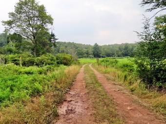 I hoped we could set a quick pace but knew that the water and mud I expected to find would slow us down. The first .6 miles gains about 350 feet to the highest point on the hike. It isn't very steep but does act as a nice warm-up! I set off very fast and found I was soon out of breath. We did not run into any blowdowns on the trail. This trail is in the Willowemoc Wild Forest but on a snowmobile trail not assigned to the NYNJTC. Once the trail leveled it was easier walking but there were many wet and muddy spots. I tried to get Sheena to follow me around the worst spots but she likes to walk through the middle of the mud. Most of the muddy spots showed tracks from an ATV or small pickup both of which should not be on the trail unless for "official" purposes. At 1.1 miles we were at the spur trail that leads down to the shore of Long Pond. We turned right and went down to the pond so that I could take some pictures. At the shores of the pond I dropped my pack and got out my camera to take some pictures. The path to the actual shore of the pond was flooded with water and was very muddy. I told Sheena to stay where she was but she followed me down the path. The skies were a flat blue with a few clouds and plenty of haze. I took a few pictures of diffeet angles and zooms. I returned to my pack where I got a bar before packing up as we returned to the main trail. We turned right and were soon at the first trail junction. We turned right at the junction at 1.3 miles and continued to find wet and muddy places on the trail. Some of these spots ran from one side of the trail to the other and were hard to avoid. We continued to find the trail free of blowdowns which was surprising. By 10:40 AM we had walked 1.8 miles and were passing the yellow spur trail to the lean-to. I though about going to the lean-to as a crew of young volunteers had done a lot of work to improve it. In the end I decided to bypass the lean-to to make sure I was home at the right time.
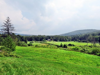 After passing the trail to the lean-to, we continued to find many wet and muddy places with detours solidified by many hikers. There isn't much to see on this section of trail so I concentrated on avoiding the deep mud as much as possible without ruining the trail. We continued on the main trail to the point where it intersects a woods road at 2.6 miles. We turned left on the woods road and found it to be almost completely dry! We followed the road until the intersection with Basily Road at 2.85 miles where we continued on Basily Road by bearing left. This section of road was wetter and muddier than the upper part of the road but the mud was, for the most part, easily avoided. It did seem to get getting warmer the longer we hiked and I was sweating with the workout. As we approached the Peters Hunting Camp, I got ready to put Sheena on her leash if anyone was at the camp. In the past, the road to the hunting camp crossed a stream which the beavers had dammed. There was a small wooden bridge but both the road and the bridge were usually flooded. As this are came into sight, I did a double-take as the road was now elevated and completely dry with a culvert to allow Te stream to pass beneath. Large rocks a had been placed to resist erosion and packed earth formed the road. I stopped to take some pictures of the beaver pond and the new road. We came to the bridge over the stream near the camp which is showing signs of wear from snowmobiles passing over it even though there is a sign that states "Private Bridge". I have secured permission to hike across this land in the past and "Stay on the trail" signs seem to indicate that the owners will allow hikers. I assume the "Private Bridge - No thru traffic" refers to motorized vehicles and not hikers. The ford in the river shows extensive use as does the "road" on both sides on the ford. As we headed toward the bridge, A NYS Police cruiser came down the road, crossed the bridge, and drove to the Peter's Hunting Camp!. We crossed the bridge to continue the trip back to the car and started up the little hill from the hunting camp. We stopped again so that I could take a few shots of the valley which looked peacefully bucolic. After packing up my camera, the police car came up the road and passed us without stopping although we both waved.
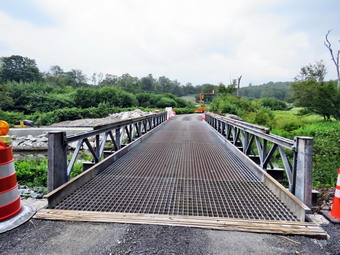 I assumed that the trooper was local and knew the owners of the camp. Once we started walking again we kept a fast pace as the road now had less water and mud. The road is packed gravel until it breaks out of the forest where it is paved. There were several places to camp along the road but only one was occupied. Several of the campsites looked well-used and had stone fireplaces or fire rings. Soon we were at the end of the gravel road where the pavement started. There was a sign indicating road work ahead and I could only imagine that the SC DPW was working on one of the bridges. We continued down the road toward the parking area and our car at a near record pace until we came to the traffic control light for the one lane temporary bridge. No one was working in the area. The bridge roadway was steel with large rectangular "holes". Before I could restrain Sheena, she had run out onto the bridge! She made it about a third of the way across based on her shear speed but then stopped. She did not want to go any farther because of the holes in the roadway. I told her to stay, walked to the other side, dropped my pack, and went back to carry her over the bridge. When I picked her up she did not struggle and rusted me to get her to the other side. I was glad she was so lithe and muscular and not a few pounds heavier! I did stop to take a few shots of the bridge and the stream before shouldering the pack to carry on. We continued at an accelerated pace back to the parking area. When we arrived, there was one car parked and the a woman appeared to be changing her shoes and leaving. I though perhaps she had done a run. We were back at the car at 12:20 PM having hiked 5.9 miles in 2 hours and 35 minutes with only 10 minutes of stopped time. The elevation gain was only about 533 feet most of which was at the beginning of the hike.
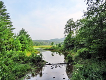
![]()
![]()
![]()
![]()
![]() On Tuesday, August 5th I planned to hike Balsam Lake Mountain as I had not done a 3500 foot peak in some time. The problem was that I had ambulance coverage from 8:00 AM to 2:00 PM and did not think that would be enough time to enjoy the hike. In addition, the smoke from Canadian wildfires was causing a hazy overcast and I wanted a sunny day for the fire tower. I chose to do a rolling hike of a little over 6 miles at Frick and Hodge Ponds. I had not done this hike in some time and was anxious to test my fitness. I asked Cindy if she would like to hike and she said "No". I started to get ready at 8:45 AM with the temperature at 63 degrees on the back porch. Sheena had been very quiet but did not let me out of her sight as I was getting ready. I got dressed in a Columbia Omni-shade long-sleeved crew top with a short-sleeved baselayer. I put on a pair of RailRiders hiking pants which are expensive but last along time and have features like deep pockets and a generous cut which I really like. These pants do not have Velcro closures at the ankles to discourage sticks and gravel from getting into my shoes and to combat ticks. I decided to put on my Keen Durand hiking boots which fit well. I added a new pair of Xstance insoles in an effort to find the best support and cushioning for my feet. These insoles have shock absorbing gel pads, TPU arch support, and memory foam cushioning all wrapped in a breathable fabric. The insoles have been hyped by their manufacturer and seemed to be living up to their claims. I also added my OR floppy hat which I have decided shields me from the sun and allows me to spray some insect repellant on it rather than on me. I put my gear in the back and Sheena in the backseat and I pulled out of Livingston Manor at 9:05 AM. I drove out DeBruce Road about 6 miles and turned left on Mongaup Pond Road. When the road split, I stayed left on Beech Mountain Road to the Frick Pond trailhead. There was one car parked in the smaller lot and none in the larger. I chose the smaller lot and set my GPS. Before leaving I sprayed some natural insect repellant on my hat, shirt, and neck. We started out on the woods road toward Frick Pond at 9:25 AM. The trail was muddy in a few places but as soon as we passed the register it was mostly dry. There was no water running across the trail which is usually the case. It was obvious that a large vehicle had been on the trail recently. I was not sure if this was for an official reason or if somebody had just decided to bring a large UTV! At Gravestone Junction, we stayed to the left and walked along the trail down to the bridge at the outlet of Frick Pond. The truck tracks continued in this direction. The trail was in poor shape as if no maintenance had been done this season. I used to maintain the trails in the area but the NYNJTC decided I was not doing a good job. They decided to change from individual maintainers to elite trail crews. The result has not benefit the condition of the trails. At the bridge the tracks ended and there was yellow CAUTION tape across the little path down to the outlet of the pond. There was no obvious reason for the CAUTION so I wondered what was going on. The skies were almost hazy but there was a lot of blue and a few white clouds. I did not plan to stop but this scene always mesmerizes me. I took off my pack and got out the camera and took shots of the pond and Beech Mountain. After a short pause, I packed up, and we continued our hike. We walked along the west side of the pond where the trail was nearly dry.
On Tuesday, August 5th I planned to hike Balsam Lake Mountain as I had not done a 3500 foot peak in some time. The problem was that I had ambulance coverage from 8:00 AM to 2:00 PM and did not think that would be enough time to enjoy the hike. In addition, the smoke from Canadian wildfires was causing a hazy overcast and I wanted a sunny day for the fire tower. I chose to do a rolling hike of a little over 6 miles at Frick and Hodge Ponds. I had not done this hike in some time and was anxious to test my fitness. I asked Cindy if she would like to hike and she said "No". I started to get ready at 8:45 AM with the temperature at 63 degrees on the back porch. Sheena had been very quiet but did not let me out of her sight as I was getting ready. I got dressed in a Columbia Omni-shade long-sleeved crew top with a short-sleeved baselayer. I put on a pair of RailRiders hiking pants which are expensive but last along time and have features like deep pockets and a generous cut which I really like. These pants do not have Velcro closures at the ankles to discourage sticks and gravel from getting into my shoes and to combat ticks. I decided to put on my Keen Durand hiking boots which fit well. I added a new pair of Xstance insoles in an effort to find the best support and cushioning for my feet. These insoles have shock absorbing gel pads, TPU arch support, and memory foam cushioning all wrapped in a breathable fabric. The insoles have been hyped by their manufacturer and seemed to be living up to their claims. I also added my OR floppy hat which I have decided shields me from the sun and allows me to spray some insect repellant on it rather than on me. I put my gear in the back and Sheena in the backseat and I pulled out of Livingston Manor at 9:05 AM. I drove out DeBruce Road about 6 miles and turned left on Mongaup Pond Road. When the road split, I stayed left on Beech Mountain Road to the Frick Pond trailhead. There was one car parked in the smaller lot and none in the larger. I chose the smaller lot and set my GPS. Before leaving I sprayed some natural insect repellant on my hat, shirt, and neck. We started out on the woods road toward Frick Pond at 9:25 AM. The trail was muddy in a few places but as soon as we passed the register it was mostly dry. There was no water running across the trail which is usually the case. It was obvious that a large vehicle had been on the trail recently. I was not sure if this was for an official reason or if somebody had just decided to bring a large UTV! At Gravestone Junction, we stayed to the left and walked along the trail down to the bridge at the outlet of Frick Pond. The truck tracks continued in this direction. The trail was in poor shape as if no maintenance had been done this season. I used to maintain the trails in the area but the NYNJTC decided I was not doing a good job. They decided to change from individual maintainers to elite trail crews. The result has not benefit the condition of the trails. At the bridge the tracks ended and there was yellow CAUTION tape across the little path down to the outlet of the pond. There was no obvious reason for the CAUTION so I wondered what was going on. The skies were almost hazy but there was a lot of blue and a few white clouds. I did not plan to stop but this scene always mesmerizes me. I took off my pack and got out the camera and took shots of the pond and Beech Mountain. After a short pause, I packed up, and we continued our hike. We walked along the west side of the pond where the trail was nearly dry.
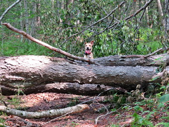 At the junction with the Big Rock Trail, we turned left to stay on the Quick Lake Trail. We followed the trail which was damp with some mud that was easily avoided. There were some small blowdowns on the trail and one large one that was blocking the trail. This large blowdown had been in place for several months but should have been cleared much sooner. Resourceful hikers has detoured around the blowdown. We walked through the "spruce tunnel" where the trail crew had cut some of the blowdowns that had been down across the trail. We came to the small stream through the woods and it was nearly dry with none of the small "falls" that are usually present. I stopped to take a few pictures of the stream before hopping across on the stepping stones. Sheena just walks through the water and mud as if it are not there. After crossing we continued on the Quick Lake Trail to Iron Wheel Junction. This part of the trail showed signs that the heavy rains had eroded parts of the trail and there were still some muddy spots. There were some more blowdowns of varying sizes on this section of trail. At Iron Wheel Junction, we turned left to stay on the Quick Lake Trail. We did stop so that I could take some shots of the wheels with and without Sheena. I walk on the Quick Lake Trail started a long uphill climb which is not steep but which I could feel in my legs and breathing. When we came to the junction where the snowmobile trail turns left, I noticed that there was some indication that people had walked on the trail. It is 1.6 miles from Iron Wheel Junction to Junkyard Junction with an elevation gain of almost 500 feet. This walk often seems long and this was one of those days since the heat and humidity slowed me down. Sheena was completely unaffected as she ran ahead and then came running back to check on me. The trail was eroded in many places showing the power of the water that runs down the trail. The walk to Junkyard Junction seemed long but was moderated by Sheena's antics! At the junction, we turned right onto the Flynn Trail and started toward Hodge Pond. This trail was is usually wet and muddy along its entire length but on this day it was dry making the hiking much easier. The Flynn Trail from Junkyard Junction to Hodge Pond is .85 miles and drops 165 feet to the shores of the pond. After passing through the gate that marks the boundary with the Beaverkill Land Trust property, we walked down the hill toward the pond and turned left to take the jeep trail around the back of the pond. I knew that the Flynn Trail at the outlet of Hodge Pond had been flooded by the work of some beavers! The jeep trail had several blowdowns especially on the uphill part before we dropped to Te field at the outlet of the pond. We entered the field and Sheena ran into the outlet of the pond chasing some waterfowl. I called her back and we crossed the open area to the shore of the pond.
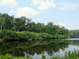 I walked over to the shores= of the pond where I put down my pack and got out Sheena's water bowl. I filled it with water from the pond and pit it down by my pack. Sheena had a good drink while I got out my camera. The skies were blue with a few white clouds but the haze was also present. I took some pictures of the pond from different zooms. I also took pictures of the expanded outlet to the pond that had flooded the Flynn Trail. After a short time, I ate a bar and got a drink , before packing up to continue on the Flynn Trail. We walked back to the Flynn Trail to the point where it re-entered the woods and began the walk up the hill. This part of the trail was almost dry with only a few damp spots. Not very far up the hill I looked up to see a young and and young woman walking toward us. I took Sheena off the trail to let them pass. They stopped and we talked for a minute. They said they were doing the loop so I cautioned them about the flooded Flynn Trail and suggested the jeep trail around the back of the pond. We continued to the top of the hill where a woods road branches to the left. We turned right to stay on the Flynn Trail which is relatively flat to the junction with the Big Rock Trail at 4.8 miles into the hike. We passed through the gate marking the border with the BLT property and soon after arrived at the junction with the Big Rock Trail. The Flynn Trail continued straight ahead and we continued in that direction. At least the Flynn Trail either descends or is flat all the way back to the car! The walk on this day seemed to go quickly as we set a fast pace downhill. At 5.4 miles we came to the path to the clearing on the east side of the trail. At some point we ran into two young men coming up the trail. I again took Sheena aside as she has come to expect as the young men passed with a greeting. We continued downhill and, as we neared the last gate, we ran into another group of three young men headed up the trail. This was as many people as I had run into on a Tuesday in a very long time! It seemed as if the gate across the trail came up sooner than I expected. Just before the gate we turned left to follow the Flynn Trail and to avoid the private property around the cabin. We continued on the trail passing the register box. I could hear some conversation out in parking lot about parking a car. We emerged from the trail and found at least 8 young men a women in the road. I noticed that someone had parked so it was impossible for me to get into my car. I pointed out the large parking area with no cars! Somehow the message did not seem to sink in. The owner the car next to me backed out, waited for me to leave, and pulled Ito the spot where I was parked! When we arrived back at the parking lot, the small lot was full and the large lot was empty. We were back at the car by 12:45 PM having covered 6.6 miles in 3 hours and 20 minutes with 15 minutes of stopped time. The elevation gain was 905 feet. Our moving speed was 2.1 mph with an overall speed of 2.0 mph.
![]()
![]()
![]()
![]() On Monday, August 4th I had planned to hike Balsam Lake Mountain as I had ambulance coverage from 9:00 AM to 5:00 PM. I got up late due to two overnight calls. I looked outside and saw the haze from the Canadian wildfires was heavy. I decided to ask Cindy if she wanted to hike some flat route and she agreed. We decoded to go to Bloomville and hike some miles of the Catskill Rail Trail that extends all the way to Roxbury. Like most trail it is very flat which suits Cindy just fine. Of course Sheena would go with us amd was already running between us to make sure she was not forgotten. I have transitioned from using a leash all the time to using a GarmimSport PRO electronic collar which has many versatile settings and seems to do the job. This allows Sheena to roam and keeps me sane by not having to yank on her leash. It seems that Sheena likes hiking as she smells my clothes and then runs to sit by the door! As I started to get dressed the temperature was comfortable 74 degrees. I got dressed in a new Columbia Omni-Shade Omni-Wick shirt without a baselayer. I put on a pair of RailRiders hiking pants which are expensive but last a long time and have features like deep pockets and a generous cut which I really like. I thought about wearing a pair of low-cut and lighter hiking shoes but thought the trail might be wet and muddy. I decided to put on my Keen Durand hiking boots which fit well. I added a new pair of Xstance insoles in an effort to find the best support and cushioning for my feet. These insoles have shock absorbing gel pads, TPU arch support, and memory foam cushioning all wrapped in a breathable fabric. The insoles have been hyped by their manufacturer and seemed to be living up to their claims. I grabbed a pair of Leki Makalu Lite poles I have been using for some time because they are light and lock without slipping. I grabbed my OR floppy hat and put on OR Bugout gaiters to repel the ticks. We got our gear in the car and put Sheena in the back seat. We left Livingston Manor at 10:55 AM as I drove northwest to Roscoe on State Rt 17 and then took County Route 206 toward Downsville. Somewhere along the way Cindy began to reconsider the long ride to Bloomville and suggested a route at Bear Spring WMA instead. The route she chose starts at Middle Pond on East Trout Brook Road and ascends to the eastern Ridge before coming back to the pond. It is only a little over 4 miles but has significant elevation gain to the ridge. I discussed this with Cindy but she insisted and, since it was fine with me, I agreed. Bear Spring Wildlife Management Area is between Downsville and Walton on Route 206. The area has many snowmobile and horse trails that are wide and grassy. The trails have a good surface and there are no major mountains but the climbs to the ridges can be challenging. I continued through Downsville on County Route 206 to the top of Bear Spring Mountain near Walton, NY. I turned left on East Trout Brook Road and drove south passed Launt Pond for another 1.3 miles. I parked on the left side of the road in the parking area at Middle Pond at 11:35 AM with no other cars in the lot. We have hiked here many times and seldom see anyone on the trails. I set my GPS and we got right on the trail with the temperature now at 78 degrees in the sun. .
`
On Monday, August 4th I had planned to hike Balsam Lake Mountain as I had ambulance coverage from 9:00 AM to 5:00 PM. I got up late due to two overnight calls. I looked outside and saw the haze from the Canadian wildfires was heavy. I decided to ask Cindy if she wanted to hike some flat route and she agreed. We decoded to go to Bloomville and hike some miles of the Catskill Rail Trail that extends all the way to Roxbury. Like most trail it is very flat which suits Cindy just fine. Of course Sheena would go with us amd was already running between us to make sure she was not forgotten. I have transitioned from using a leash all the time to using a GarmimSport PRO electronic collar which has many versatile settings and seems to do the job. This allows Sheena to roam and keeps me sane by not having to yank on her leash. It seems that Sheena likes hiking as she smells my clothes and then runs to sit by the door! As I started to get dressed the temperature was comfortable 74 degrees. I got dressed in a new Columbia Omni-Shade Omni-Wick shirt without a baselayer. I put on a pair of RailRiders hiking pants which are expensive but last a long time and have features like deep pockets and a generous cut which I really like. I thought about wearing a pair of low-cut and lighter hiking shoes but thought the trail might be wet and muddy. I decided to put on my Keen Durand hiking boots which fit well. I added a new pair of Xstance insoles in an effort to find the best support and cushioning for my feet. These insoles have shock absorbing gel pads, TPU arch support, and memory foam cushioning all wrapped in a breathable fabric. The insoles have been hyped by their manufacturer and seemed to be living up to their claims. I grabbed a pair of Leki Makalu Lite poles I have been using for some time because they are light and lock without slipping. I grabbed my OR floppy hat and put on OR Bugout gaiters to repel the ticks. We got our gear in the car and put Sheena in the back seat. We left Livingston Manor at 10:55 AM as I drove northwest to Roscoe on State Rt 17 and then took County Route 206 toward Downsville. Somewhere along the way Cindy began to reconsider the long ride to Bloomville and suggested a route at Bear Spring WMA instead. The route she chose starts at Middle Pond on East Trout Brook Road and ascends to the eastern Ridge before coming back to the pond. It is only a little over 4 miles but has significant elevation gain to the ridge. I discussed this with Cindy but she insisted and, since it was fine with me, I agreed. Bear Spring Wildlife Management Area is between Downsville and Walton on Route 206. The area has many snowmobile and horse trails that are wide and grassy. The trails have a good surface and there are no major mountains but the climbs to the ridges can be challenging. I continued through Downsville on County Route 206 to the top of Bear Spring Mountain near Walton, NY. I turned left on East Trout Brook Road and drove south passed Launt Pond for another 1.3 miles. I parked on the left side of the road in the parking area at Middle Pond at 11:35 AM with no other cars in the lot. We have hiked here many times and seldom see anyone on the trails. I set my GPS and we got right on the trail with the temperature now at 78 degrees in the sun. .
`
We walked down the wide path/road and across the dam that creates Middle Pond on East Trout Brook. The pond's water level was very low and only a trickle was escaping over the dam. I decided to take pictures on the way back so we continued straight up the hill. I pointed out to Cindy the sign to the right that said "New Trail". The "New Trail" is now several years old! The trail that continues straight up the hill is a wide grassy snowmobile/horse trail. The sun was out and the skies were blue with a some interesting clouds in different directions but a smoky haze was present. I knew that we could do a clockwise or anticlockwise loop and that I would leave that up to Cindy. The first left turn seemed to be a trail but I remembered from a previous trip that it ended in a small field. On one occasion I had simply bushwhacked along the brook which was easy in most spots with a few areas of dense brush. At .4 miles another trail came in from the left and I knew this was the trail we could take for a clockwise loop. Cindy elected to continue up the hill to get the major ascent in at the beginning of the hike. A little further up the hill there was an old orchard but I decided not to stop to take pictures of the gnarled, old trees. The problem with stopping was that the insects began to swarm. We continued up the hill to the area of a small pond but the view was block by brush. I noticed that Cindy was lagging behind and I slowed down to let her catch up. Sheena was ranging far and wide but stayed mostly in sight. At .65 miles we came to the junction with the McCoy Hill Cutoff which is the most direct route to the ridge. We stayed to the right to follow the trail on the longer route to the top of the ridge. Within another .1 miles the trail turned slightly right and started a steeper climb which I knew was coming. This is where the grumbling started! I know from experience that when the grumbling starts the hike is over! I immeidately turn around and started to retrace our steps. I wasn't happy as I had explained the route and we had done it before. I set a fast pace on the way back as it was all downhill and I needed some way to get some exercise. We were back at the car at 12:20 PM after Hiking 1.5 miles in 45 minutes. Our round trip driving was 90 minutes! The drive home was quiet.
![]()
![]()
![]()
![]()
![]() On Friday, August 1st, I had full ambulance coverage from 8:00 AM to 2:00 PM and decided to get in a longer hike close to home. A cold front had rolled through bringing rain and cooler weather. It was only 68 degrees as I began to get ready at 10:30 AM but I new it would be cooler in the shade. I planned take Sheena for a longer hike away from Livingston Manor and decided to go to the Parksville Rail Trail as it is close but interesting with a nice falls. I hoped there would be a higher level of water in the Little Beaverkill which would make the falls more interesting. I asked Cindy if she would like to go with us and she agreed because of the cooler temperatures and flat nature of the hike. The Parksville Rail Trail is under three miles out and back but keeping a quick pace helps increase the difficulty. Sheena actually does get in about twice the mileage that we do as she forges ahead and then comes back! I have transitioned from using a leash all the time to using a GarmimSport PRO electronic collar which has many versatile settings and seems to do the job. This allows Sheena to roam and keeps me sane by not having to yank on her leash. It seems that Sheena likes hiking as she smells my clothes and then runs to sit by the door! I got dressed in a new Columbia Omni-Shade Omni-Wick shirt without a baselayer. I put on a pair of RailRiders hiking pants which are expensive but last a long time and have features like deep pockets and a generous cut which I really like. I thought about wearing a pair of low-cut and lighter hiking shoes but thought the trail might be wet and muddy. I decided to put on my Keen Durand hiking boots which fit well. I added a new pair of Xstance insoles in an effort to find the best support and cushioning for my feet. These insoles have shock absorbing gel pads, TPU arch support, and memory foam cushioning all wrapped in a breathable fabric. The insoles have been hyped by their manufacturer and seemed to be living up to their claims. I grabbed a pair of Leki Makalu Lite poles I have been using for some time because they are light and lock without slipping. I grabbed my OR floppy hat but left yhe OR Bugout gaiters behind. I decided to take my pack as I thought I might want to take pictures and the thought of having a drink and a snack was appealing. I put our gear in the back of the car and Sheena in the back seat and we left Livingston Manor at 10:50 AM. Sheena has finally realized that she can easily jump in the back seat! I drove out Old Route 17 toward Parksville and turned left under the Quickway overpass onto Service Road. I drove toward Parksville and pulled into the parking area on the right side of the road just after Fox Mountain Rd. There were no cars parked in the lot when we arrived. I made sure Sheena's ecollar was adjusted correctly and then I let her out of the car at 11:05 AM. The temperature was 68 degrees but the sun made it feel warmer.
On Friday, August 1st, I had full ambulance coverage from 8:00 AM to 2:00 PM and decided to get in a longer hike close to home. A cold front had rolled through bringing rain and cooler weather. It was only 68 degrees as I began to get ready at 10:30 AM but I new it would be cooler in the shade. I planned take Sheena for a longer hike away from Livingston Manor and decided to go to the Parksville Rail Trail as it is close but interesting with a nice falls. I hoped there would be a higher level of water in the Little Beaverkill which would make the falls more interesting. I asked Cindy if she would like to go with us and she agreed because of the cooler temperatures and flat nature of the hike. The Parksville Rail Trail is under three miles out and back but keeping a quick pace helps increase the difficulty. Sheena actually does get in about twice the mileage that we do as she forges ahead and then comes back! I have transitioned from using a leash all the time to using a GarmimSport PRO electronic collar which has many versatile settings and seems to do the job. This allows Sheena to roam and keeps me sane by not having to yank on her leash. It seems that Sheena likes hiking as she smells my clothes and then runs to sit by the door! I got dressed in a new Columbia Omni-Shade Omni-Wick shirt without a baselayer. I put on a pair of RailRiders hiking pants which are expensive but last a long time and have features like deep pockets and a generous cut which I really like. I thought about wearing a pair of low-cut and lighter hiking shoes but thought the trail might be wet and muddy. I decided to put on my Keen Durand hiking boots which fit well. I added a new pair of Xstance insoles in an effort to find the best support and cushioning for my feet. These insoles have shock absorbing gel pads, TPU arch support, and memory foam cushioning all wrapped in a breathable fabric. The insoles have been hyped by their manufacturer and seemed to be living up to their claims. I grabbed a pair of Leki Makalu Lite poles I have been using for some time because they are light and lock without slipping. I grabbed my OR floppy hat but left yhe OR Bugout gaiters behind. I decided to take my pack as I thought I might want to take pictures and the thought of having a drink and a snack was appealing. I put our gear in the back of the car and Sheena in the back seat and we left Livingston Manor at 10:50 AM. Sheena has finally realized that she can easily jump in the back seat! I drove out Old Route 17 toward Parksville and turned left under the Quickway overpass onto Service Road. I drove toward Parksville and pulled into the parking area on the right side of the road just after Fox Mountain Rd. There were no cars parked in the lot when we arrived. I made sure Sheena's ecollar was adjusted correctly and then I let her out of the car at 11:05 AM. The temperature was 68 degrees but the sun made it feel warmer.
The first part of the trail before the trees was damp as the sun had evaporated the rains that had fallen for two days. Off her leash Sheena would run ahead of us a certain distance and then maintain that distance by waiting or increasing her pace. We were soon under the cover of the trees. Once we were hiking on the trail, we were sheltered from the sun but I was still warm enough. The trail was wet with soft and muddy patches in all the usual spots. The trail runs parallel to the Little Beaverkill and the new section of State Route 17. It follows the route of the O&W railroad and is very flat. Sheena was setting a quick pace and I didn't mind as long as she would listen and wait for us when necessary. Cindy was hiking a little faster than usual so we were able to stay together and talk which is something I enjoy. We continued on the trail and I noticed the water level in the stream was much higher than on my previous trip. We continued on the trail through some muddy patches until we came to the viewpoint just before the wooden walkways. This spot has a nice view down to the stream and the skies were bright and sunny with some clouds. The problem is the viewpoint is partially blocked by trees and bushes so I decided not to stop for pictures. We walked across the wooden walkways which were damp and slippery. The area before the bridge was only damp. Just after the bridge was a large patch of mud from one side of the trail to the other. The culvert under the bridge appeared permanently blocked and the water forms the mud. No one seems concerned about solving this problem. I walked around the mud to continue the hike but Sheena walked right through it. We came to the landslide that had brought down several trees that had been cut and cleared. This area is now muddy but there were some stepping stones. Sheena does not seem to mind sloshing through the water and wading through the mud. As we walked, we could hear the increase in noise from the stream. We reached the falls and I could see two people further up the trail standing by the bench near the upper rapids. They had a rather large dog with them but seemed to be content to stand and talk.
Sheena and I headed down the path to the streambed. Sheena scrambled down without stopping but I had to pick my way lever the loose gravel and slippery rocks. Once at the bottom I took off my pack and got out my camera. I took some wide-angle picture of the falls and the rapids below. I then zoomed in on various portions of the scene getting shots of the falls alone and then zeroing in in the rapids. I turned downstream and too pictures of the stream flowing a way from the falls. Before leaving, I got Sheena to sit on a rock in front of the falls. I took some pictures as she looked up the bank for Cindy and straight ahead at the camera. I put my camera in the pack, shoulder it, and headed to the trail above with Sheena behind me. I thought the two men with the dog might have walked to the falls but they were still standing and talking. I took some more shots of the falls and the rapids above them before moving on. I out Sheena on her leash and we pushed on toward the other end of the trail continuing toward Parksville with Sheena in the lead pushing the pace. As we approached the men with the dog, they said "Hello: and explained that the god, who was on a leash, was very friendly and wanted to plat. We declined the offer and continued on the trail. I did take a peek at the stream from the bench on the trail. I didn't find anything interesting so we pressed on! Within a few minutes, we were nearing the Parksville end of the trail and Sheena was eager to continue. We came to a spot in the trail where we could see the other side. The large dog that is often there was absent. We continued toward Parksville where the dogs near the end of the trail that had been absent during cold weather were making some nice but appeared to be inside. We tagged the end of the trail when we reached the sign at the Parksville end of the rail trail. It was 11:45 AM and it had taken us 40 minutes to hike the length of the trail including the stop for pictures at the falls. We immediately turned around and started back toward the car. We set a fast pace back from the falls with Sheena in the lead. We met the men with the dog standing exactly where they had been. After passing them, I let Sheena off her leash so she could run up and down the trail and work off her energy. She took advantage and ran an extra-long distance before turning around ad roaring back passed us. When we came to the bridge, we hopped around the mud while Sheena pushed through. We arrived back at the car at 12:15 PM after hiking over 2.7 miles in 1 hour and 30 minutes which was slow but allowed a relaxed pace and time for photography. The temperature at the car was 73 degrees and very comfortable.
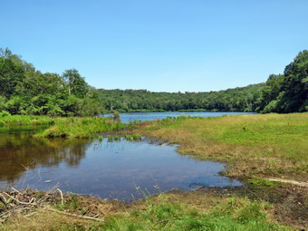
![]()
![]()
![]()
![]()
![]() On Tuesday, July 29th, I planned to go for a hike with my grandson Bryce whose school has ended for the year. I waited for some time for Bryce to appear and the called his father. Karl let me know Bryce had gone with a group to Medieval Times in New Jersey! I was very disappointed that Bryce was not going to be hiking with us and that he had not let me know. I decided I would still go hiking with Sheena since Cindy had already told me it was too warm to hike! I thought we would go to the Frick Pond area and hike up the Flynn Trail. Once on the Flynn Trail there were several choices we could make for our route. As I got my gear together at 10:15 AM, Sheena seemed to be in complete agreement with my decision as she followed me around as I was dressing. The temperature was 89 degrees and it felt at least that warm because of the bright sun. I put on a long-sleeved Columbia Omni-Shade crew top without a baselayer. I put on a pair of RailRiders hiking pants which are expensive but last a long time and have features like deep pockets and a generous cut which I really like. The pants have Velcro closures at the ankles. I decided to put on my Keen Durand hiking boots which I ordered a half size larger than the previous pair. These shoes fit well out of the box but get much tighter when I add a decent insole. Without the third party insole, my feet hurt from the lack of support. I added a new pair of Xstance insoles in an effort to find the best support and cushioning for my feet. These insoles have shock absorbing gel pads, TPU arch support, and memory foam cushioning all wrapped in a breathable fabric. The insoles have been hyped by their manufacturer and they really do seem to deliver. I also added a OR floppy hat which shields me from the sun. I put on my OR Bugout gaiters to repel the ticks which have been plentiful so far this season. I put our gear in the car and Sheena in the backseat. I drove out DeBruce Road at 10:35 AM. After 6 miles I turned left on Mongaup Road. Where the road splits, I stayed left on Beech Mountain Road and continued to the parking areas at the end of the road. There were no cars in the lots so I parked in the smaller lot at 10:55 AM. We promptly got out of the car to start our hike. I regretted that I had not brought my GPS unit to keep track of our current Hike.
On Tuesday, July 29th, I planned to go for a hike with my grandson Bryce whose school has ended for the year. I waited for some time for Bryce to appear and the called his father. Karl let me know Bryce had gone with a group to Medieval Times in New Jersey! I was very disappointed that Bryce was not going to be hiking with us and that he had not let me know. I decided I would still go hiking with Sheena since Cindy had already told me it was too warm to hike! I thought we would go to the Frick Pond area and hike up the Flynn Trail. Once on the Flynn Trail there were several choices we could make for our route. As I got my gear together at 10:15 AM, Sheena seemed to be in complete agreement with my decision as she followed me around as I was dressing. The temperature was 89 degrees and it felt at least that warm because of the bright sun. I put on a long-sleeved Columbia Omni-Shade crew top without a baselayer. I put on a pair of RailRiders hiking pants which are expensive but last a long time and have features like deep pockets and a generous cut which I really like. The pants have Velcro closures at the ankles. I decided to put on my Keen Durand hiking boots which I ordered a half size larger than the previous pair. These shoes fit well out of the box but get much tighter when I add a decent insole. Without the third party insole, my feet hurt from the lack of support. I added a new pair of Xstance insoles in an effort to find the best support and cushioning for my feet. These insoles have shock absorbing gel pads, TPU arch support, and memory foam cushioning all wrapped in a breathable fabric. The insoles have been hyped by their manufacturer and they really do seem to deliver. I also added a OR floppy hat which shields me from the sun. I put on my OR Bugout gaiters to repel the ticks which have been plentiful so far this season. I put our gear in the car and Sheena in the backseat. I drove out DeBruce Road at 10:35 AM. After 6 miles I turned left on Mongaup Road. Where the road splits, I stayed left on Beech Mountain Road and continued to the parking areas at the end of the road. There were no cars in the lots so I parked in the smaller lot at 10:55 AM. We promptly got out of the car to start our hike. I regretted that I had not brought my GPS unit to keep track of our current Hike.
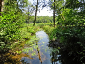 The skies were bright and blue with plenty of sun and a few puffy white clouds. We crossed the road and started out on the Flynn Trail which was badly eroded just off the road. The grass was high and nothing was trimmed. This would continue throughout the hike with the trails showing little or no maintenance. We set a good pace through the woods on the trail. At the end of the trail we turned right on what was once Beech Mountain Road and started the long but gentle ascent to the junction with the Big Rock Trail. There was a slight breeze blowing which made me feel a little cooler than the 78 degree temperature. The trail was drier than I expected which made keeping a fast pace easier. I was lost in my own thoughts but missed having conversations with Bryce. I was trying to keep a consistent pace but also wanted to enjoy the hike. As we walked, we saw several blowdowns and many small branches and a few larger ones. It took us about an hour to hike the 1.7 miles to the junction. I considered turning left of the Big Rock Trail because of the high temperature and humidity but decided we could make Hodge Pond where I could make another decision about our route. We did not stop at the trail junction but continued straight ahead toward Hodge Pond. This section of the trail is almost flat and we passed through the gate separating state land from Beaverkill Land Trust property. At the split in the trail, we stayed to the left and followed the Flynn Trail down to the shores of the pond. I chose to do this since the walk back up this hill always seems long even though the slope is gradual. When we broke out into the clearing at the outlet end of Hodge Pond, I could see that the level of the pond was much higher than during my last visit. As we headed toward the shore of the pond, I could see that the beaver dam had been enhanced and that the water was completely covering the Flynn Trail and encroaching on the field.The beavers had dammed up the stream below the outlet and had also jammed the culvert. At the shores of the pond, I put down the pack and I took out my camera to take some pictures of the pond. I took pictures of the green trees around the pond at different zooms. I was disappointed that there were almost no clouds over the pond. Sheena walked to the edge of the water but would not take a drink as I suggested. I scooped up water from the pond in her dish and she readily drank it down. After taking some more pictures of the pond, I walked over to the outlet end to take pictures of the beaver dam and the flooded Flynn Trail. It was really amazing the increase in the size of the pond. I walked back to my pack, put the camera away and turned around to follow the Flynn Trail back the way we had come. I was warm but I followed Sheena who was setting a fast pace up the hill. The trip up the hill went faster than I remembered and we were soon walking the flat trail back to the junction with the Big Rock Trail.
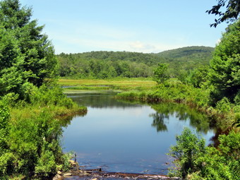 At the junction, we turned right and started down the Big Rock Trail toward Times Square. The downhill walk went very quickly although I still am fooled by the three different descents all of which look like the last! We continued on the trail which was dry making walking easy. There were a few blowdowns along the way and the grass and ferns showed almost no one had been king the trails. When we arrived at Times Square, we continued straight across on the Big Rock Trail around the back of Frick Pond. The trail around the back of the pond was damp in spots with some very wet and muddy areas. When we came to the two bridges over the inlet streams, we stopped and I got out the camera to take some pictures of the wetlands at the north end of Frick Pond. We walked through the spruce trees to the walkways. As we crossed the wooden walkways, we noticed that many of the boards were loose and that entire sections seemed to be floating in the air. I hope that the DEC has a plan to address this situation but I am not aware that they do. I stopped to take a few shots of the walkways but the light was not very good. We walked out from under the trees and had to skirt the biggest mud pit we found on the hike. At the end of the Big Rock Trail, we turned left on the Quick Lake Trail to continue on to the bridge over the outlet stream from Frick Pond. The trail continued to be damp with some mud. At the bridge, we stopped and I took out my camera to take a few more pictures. I have many pictures from this spot but can never resist taking a few shots. I find this one of the most beautiful places in the Catskills. When I was finished taking pictures, I packed up and we continued on the Quick Lake Trail through Gravestone Junction. This area had been cut by a trail crew last fall but was now overgrown with tall grasses and brush. The woods road back to the car was only damp in a few spots. We set a quick pace back to the parking area. We arrived back at the car at 1:35 PM after hiking 5.6 miles in 2 hours and 40 minutes with only 15 minutes of stopped time. The elevation gain was 880 feet. The temperture at the care was 84 degrees. I thought about stopping at Mongaup Falls as all the cars that had been there were gone. In the end I continued home as I was a little tired. There had been no ambulance calls which is unusual.
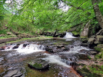
![]()
![]()
![]()
![]()
![]() On Monday, July 28th, I had full ambulance coverage from 9:00 Am to 2:00 PM and decided to get in a longer hike close to home. It was already 84 degrees as I began to get ready at 10:30 AM but I new it would be cooler in the shade. I planned take Sheena for a longer hike away from Livingston Manor and decided to go to the Parksville Rail Trail as it is close but interesting with a nice falls. Cindy should have gone with us but made the excuse that it was too hot! The Parksville Rail Trail is under three miles out and back but keeping a quick pace helps increase the difficulty. I also knew that we could hike another section from Fox Mt Road to Old Liberty Road to add some distance. Sheena actually does get in about twice the mileage that I do as she forges ahead and then comes back to me! I have transitioned from using a leash all the time to using a GarmimSport PRO electronic collar which has many versatile settings and seems to do the job. This allows Sheena to roam and keeps me sane by not having to yank on her leash. It seems that Sheena likes hiking as she smells my clothes and then runs to sit by the door! I got dressed in a new Columbia Omni-Shade Omni-Wick shirt without a baselayer. I put on a pair of RailRiders hiking pants which are expensive but last a long time and have features like deep pockets and a generous cut which I really like. I thought about wearing a pair of low-cut and lighter hiking shoes but thought the trail might be wet and muddy. I decided to put on my Keen Durand hiking boots which fit well. I added a new pair of Xstance insoles in an effort to find the best support and cushioning for my feet. These insoles have shock absorbing gel pads, TPU arch support, and memory foam cushioning all wrapped in a breathable fabric. The insoles have been hyped by their manufacturer and seemed to be living up to their claims. I grabbed a pair of Leki Makalu Lite poles I have been using for some time because they are light and lock without slipping. I grabbed my OR floppy hat and OR Bugout gaiters. I decided to take my pack as I though I might want to take pictures and the thought of having a drink and a snack was appealing. I put our gear in the back of the car and Sheena in the back seat and we left Livingston Manor at 10:50 AM. Sheena has finally realized that she can easily jump in the back seat! I drove out Old Route 17 toward Parksville and turned left under the Quickway overpass onto Service Road. I drove toward Parksville and pulled into the parking area on the right side of the road just after Fox Mountain Rd. There were two cars parked in the lot when we arrived. I made sure Sheena's ecollar was adjusted correctly and then I let her out of the car at 11:05 AM. The temperature was 82 degrees and the sun made it feel warmer.
On Monday, July 28th, I had full ambulance coverage from 9:00 Am to 2:00 PM and decided to get in a longer hike close to home. It was already 84 degrees as I began to get ready at 10:30 AM but I new it would be cooler in the shade. I planned take Sheena for a longer hike away from Livingston Manor and decided to go to the Parksville Rail Trail as it is close but interesting with a nice falls. Cindy should have gone with us but made the excuse that it was too hot! The Parksville Rail Trail is under three miles out and back but keeping a quick pace helps increase the difficulty. I also knew that we could hike another section from Fox Mt Road to Old Liberty Road to add some distance. Sheena actually does get in about twice the mileage that I do as she forges ahead and then comes back to me! I have transitioned from using a leash all the time to using a GarmimSport PRO electronic collar which has many versatile settings and seems to do the job. This allows Sheena to roam and keeps me sane by not having to yank on her leash. It seems that Sheena likes hiking as she smells my clothes and then runs to sit by the door! I got dressed in a new Columbia Omni-Shade Omni-Wick shirt without a baselayer. I put on a pair of RailRiders hiking pants which are expensive but last a long time and have features like deep pockets and a generous cut which I really like. I thought about wearing a pair of low-cut and lighter hiking shoes but thought the trail might be wet and muddy. I decided to put on my Keen Durand hiking boots which fit well. I added a new pair of Xstance insoles in an effort to find the best support and cushioning for my feet. These insoles have shock absorbing gel pads, TPU arch support, and memory foam cushioning all wrapped in a breathable fabric. The insoles have been hyped by their manufacturer and seemed to be living up to their claims. I grabbed a pair of Leki Makalu Lite poles I have been using for some time because they are light and lock without slipping. I grabbed my OR floppy hat and OR Bugout gaiters. I decided to take my pack as I though I might want to take pictures and the thought of having a drink and a snack was appealing. I put our gear in the back of the car and Sheena in the back seat and we left Livingston Manor at 10:50 AM. Sheena has finally realized that she can easily jump in the back seat! I drove out Old Route 17 toward Parksville and turned left under the Quickway overpass onto Service Road. I drove toward Parksville and pulled into the parking area on the right side of the road just after Fox Mountain Rd. There were two cars parked in the lot when we arrived. I made sure Sheena's ecollar was adjusted correctly and then I let her out of the car at 11:05 AM. The temperature was 82 degrees and the sun made it feel warmer.
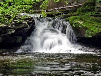 The first part of the trail before the trees was only damp as the sun had evaporated the rains and it had not rained in several days. Off her leash Sheena would run ahead of me a certain distance and then maintain that distance by waiting for me or increasing her pace. We were soon under the cover of the trees. Once we were hiking on the trail, we were sheltered from the sun but I was still warm but there was a Bree that made it quite pleasant. The trail was damp with soft and muddy patches in all the usual spots. The trail runs parallel to the Little Beaverkill and the new section of State Route 17. It follows the route of the O&W railroad and is very flat. Sheena was setting a quick pace and I didn't mind as long as she would listen and wait for me when necessary. We didn't get very far before I looked up and saw a couple walking toward us with a dog on a leash. I pulled Sheila to the side of the trail and waited until they passed. Both people thought Sheena was pretty and well-behaved. We continued on the trail and I noticed the water level in the stream was lower than on our previous trip. We continued on the trail through some muddy patches until we came to the viewpoint just before the wooden walkways. This spot has a nice view down to the stream but the skies were overcast and the viewpoint was partially blocked by trees and bushes. . We walked across the wooden walkways which were damp and slippery. The area before the bridge was only damp. Just after the bridge was a large patch of mud from one side of the trail to the other. The culvert under the bridge appeared permanently blocked and the water forms the mud. No one seems concerned about solving this problem. I walked around the mud to continue the hike but Sheena walked right through it. I could see another couple hiking toward us and I called Sheena to the side of the trail so that they could pass. Both people thought Sheena was pretty and well-behaved. We came to the landslide that had brought down several trees that had been cut and cleared. This area is now muddy but there were some stepping stones. Sheena does not seem to mind sloshing through the water and wading through the mud. As we walked, we could hear the increase in noise from the stream. We reached the falls and I inspected them and found the water was lower than last time. There was also a new tree trunk in the lower falls. Several people were in the area of the base of the falls and I decided not to try to get pictures.
 We pushed on toward the other end of the trail continuing toward Parksville with Sheena in the lead pushing the pace. I did take a peek at the stream from the bench on the trail. I didn't find anything interesting so we pressed on! Within a few minutes, we were nearing the Parksville end of the trail and Sheena was eager to continue. We came to a spot in the trail where we could see the other side. The large dog that is often there was absent. We continued toward Parksville where the dogs near the end of the trail that had been absent during cold weather were no-shows on this hot day. We tagged the end of the trail when we reached the sign at the Parksville end of the rail trail. It was 11:33 AM and it had taken us 28 minutes to hike the length of the trail non-stop. We immediately turned around and started back toward the car. We set a fast pace back from the falls with Sheena in the lead. We met the couple with the dog and, later, the other couple hiking back towards Parksville. When we came to the bridge, I hopped around the mud while Sheena pushed through. We arrived back at the car at 12:01 PM after hiking over 2.7 miles in 56 minutes which was fast. At this point I decided we would get a drink and then hike the other section toward Sonoma Falls and Old Liberty Road.
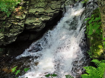 From the parking area we walked to Service Road and turned left and left again on Fox Mountain Road. We walked under the Quickway and to the intersection of Fox Mounatin Road and Benton Hollow Road. It seemed that road crews were constructing a new road on the left. We hopped the guard rail and immediately came to what was left of the trestle supports that carried the railroad tracks over the stream. I noticed what remained of a painting on the trestle. I had seen this painting before but had not realized it was a memorial to NASCAR driver Davey Allison #28 who drove the Texaco-Havoline Ford car. Allison died in a helicopter crash in 1993. We walked up the trail to left to the top of the trestle where I released Sheena from her leash. As we entered the shade of the trees, it immediately seemed a little cooler. The trail was well defined and stretched ahead for some distance. Like most rail trails it is very straight. The hope is to connect the Parksville Rail Trail to all the sections that stretch as far as Livingston Manor. We started to walk along the trail and I noticed there was quite a bit of traffic on the Quickway and on Service Road! The land dropped off steeply to the Little Beaverkill on the right. The stream volume was fairly low as there had been no storms lately. On the left were some "cliffs" which were the result of the railroad cutting a path for the tracks. There were several blowdowns along the way since this part of the trail is not maintained. Some had been cut and some not. Sheena was ranging ahead but not as far as usual. She seemed a little spooked by the traffic noise. It was a pleasant walk but the insects were out in force which reminded me to make sure I had repellant in my pack. There were a few small blowdowns on the trail which could be removed with hand tools. I walked over or around these and removed some small branches on the trail as we walked. One blowdown was about 4 feet high and 6 feet across. Instead of walking around Sheena took off, sailed through the air and landed on the other side. She id this with seemingly little effort and no wind up. The trail was damp in me places and muddy in a few others. There are two places along the trail where there are piles of garbage. It is hard to determine why they are there. Both piles have tarps over them which seemed to indicate someone once valued the items. A VW bug was just over the bank on the right after the first pile of debris. We soon came to a gate on the trail which was odd since it is state land. No one seems to know why the gate is there or who placed it. We walked around the gate and continued on the trail. There was a path to the left just after the gate. It looked interesting but we stayed on the rail trail.
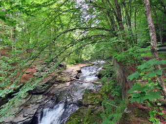 The rail trail in this area is grassy but the grass was mowed. Soon we came to a small pond on the right with a red building behind it. The building looked to be in good shape but the windows were all boarded up. There was a definite path between the pond on the right and the wetlands on the left of the trail. It looked like a beaver trail to me but I could not see any dam, lodge, or even any trees that the beavers had cut. After hiking about 1.3 miles, we came to a driveway on the left which leads to the Sonoma Falls property. I knew this was private land and I decided on this day to continue on the rail trail. At one time there was a campground on the property. Some local business people bought the property and built a cider mill and market. They took the time to construct some hiking trails along the stream. I remember that the falls were very nice with at least five separate drops which increased in height the farther upstream one ventured. The business closed when not enough people would go out of their way to visit. I noticed that the roof on the main building was collapsing which made me sad. I had hoped someone would buy the property and restart a business there. We continued on the rail trail toward Old Liberty Road. This section went quickly but I got to examine the cliffs on the left and the stream on the right. We reached the gate on Old Liberty Road at 12:40 PM and turned around. The trail extends beyond this point to parallel the road to the old trestle at the intersection with Dahlia Road. We kept a fast pace back to the car passing the driveway to Sonoma Falls. When we reached the gate, we passed around to the right and continued our fast-paced walk back to the car with Sheena running ahead and coming back to me many times. Sheena is only 1 year old and loves to get out and follow her nose every chance she gets. Sheena began to sit down and wait for me and I decided she might need a drink. I emptied my water bottle into her water bowl and she drank it all down. From that point on she did not stop as we reached Fox Mt Road and turned left. I put Sheena on her leash to walk back to Service Road to the car. We were back at the car at 1:20 PM having hiked about 6 miles in 2 hours and 15 minutes with very little stopped time. I do hope the plans to connect the sections of the rail trails are successful! It seems my hope that someone would reopen Sonoma Falls is probably not going to happen. There had been two ambulance calls but that didn't bother me as the crew covered both
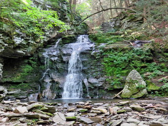
![]()
![]()
![]()
![]()
![]() On Thursday, July 24th, I planned to go on a longer hike with my grandson Bryce since I had coverage for ambulance calls from 8:00 Am to 2:00 PM. The forecast called for a sunny day with clouds but no chance of showers. I had thought about going to Bear Spring WMA but decided to go to Trout Pond to walk the loop and visit Russell Brook Falls. This area is closer to home and more interesting. I was interested to see the effect of alternating rain storms and dry spells was having on the water going over the falls and the level of Trout Pond. When I got up at 9:00 AM, the skies were bright and sunny with a few white clouds. The temperature was 67 degrees and the humidity seemed low compared to the last few days. I started to get ready at 9:30 AM with Sheena acting very enthusiastic about getting out as it had been almost a week. I decided to wear a new Columbia Omni-Shade Omni-Wick crew shirt without a baselayer. I wore my Railriders hiking pants which are expensive but last along time and have features like deep pockets and a generous cut which I really like. The pants have Velcro closures at the ankles. I thought about warmer pants but decided against it. I decided to put on my Keen Durand hiking boots which fit well. I added a new pair of Xstance insoles in an effort to find the best support and cushioning for my feet. These insoles have shock absorbing gel pads, TPU arch support, and memory foam cushioning all wrapped in a breathable fabric. The insoles have been hyped by their manufacturer and seemed to be living up to their claims. I grabbed a pair of Leki Makalu Lite poles I have been using for some time because they are light and lock without slipping. I put on my OR BugOut gaiters as I knew the trail might be wet and muddy from the recent rains. These gaiters also help to ward off ticks. I also decided to wear my OR floppy hat. I put our gear in the back and Sheena in the backseat and pulled out of Livingston Manor at 10:00 AM. I headed to Roscoe on State Route 17, got off at exit 94 and got on Route 206. I followed it across the Delaware County line to Morton Hill Road. After a left turn on Morton Hill Road, I drove toward the intersection with Russell Brook Road. There were no cars parked in the "lot" at the intersection. This area is private property but people insist on parking there despite the signs. I turned left on Russell Brook Road to drive to the lower parking area. There were no tents set up at the first camping area on the right and none at the first area on the left.
On Thursday, July 24th, I planned to go on a longer hike with my grandson Bryce since I had coverage for ambulance calls from 8:00 Am to 2:00 PM. The forecast called for a sunny day with clouds but no chance of showers. I had thought about going to Bear Spring WMA but decided to go to Trout Pond to walk the loop and visit Russell Brook Falls. This area is closer to home and more interesting. I was interested to see the effect of alternating rain storms and dry spells was having on the water going over the falls and the level of Trout Pond. When I got up at 9:00 AM, the skies were bright and sunny with a few white clouds. The temperature was 67 degrees and the humidity seemed low compared to the last few days. I started to get ready at 9:30 AM with Sheena acting very enthusiastic about getting out as it had been almost a week. I decided to wear a new Columbia Omni-Shade Omni-Wick crew shirt without a baselayer. I wore my Railriders hiking pants which are expensive but last along time and have features like deep pockets and a generous cut which I really like. The pants have Velcro closures at the ankles. I thought about warmer pants but decided against it. I decided to put on my Keen Durand hiking boots which fit well. I added a new pair of Xstance insoles in an effort to find the best support and cushioning for my feet. These insoles have shock absorbing gel pads, TPU arch support, and memory foam cushioning all wrapped in a breathable fabric. The insoles have been hyped by their manufacturer and seemed to be living up to their claims. I grabbed a pair of Leki Makalu Lite poles I have been using for some time because they are light and lock without slipping. I put on my OR BugOut gaiters as I knew the trail might be wet and muddy from the recent rains. These gaiters also help to ward off ticks. I also decided to wear my OR floppy hat. I put our gear in the back and Sheena in the backseat and pulled out of Livingston Manor at 10:00 AM. I headed to Roscoe on State Route 17, got off at exit 94 and got on Route 206. I followed it across the Delaware County line to Morton Hill Road. After a left turn on Morton Hill Road, I drove toward the intersection with Russell Brook Road. There were no cars parked in the "lot" at the intersection. This area is private property but people insist on parking there despite the signs. I turned left on Russell Brook Road to drive to the lower parking area. There were no tents set up at the first camping area on the right and none at the first area on the left.
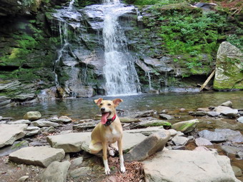 I decided not to stop on the right side of the road near the upper drop of Russell Brook Falls. I continued down to the lower parking area where one car was parked. We got out of the car and let Sheena out so she could roam around. I set my GPS unit so I could record our hike. We started down the woods road toward the bridge across Russell Brook at 10:25 AM with the temperature at 78 degrees. We crossed the bridge and found that the Japanese knotweed was growing out into the trail and had not been trimmed back. It is a shame the DEC has not kept this trimmed back as the area is very popular and used by many people. We turned right on the path toward Russell Brook Falls and found it had been trimmed back but what had been cut had not been cleared. We walked the path toward the falls. As we started down the bank, I could see there was nobody at the falls which I knew would make taking pictures easier. Sheena ran down to the stream to get a drink and walk in the water. The bank in this area was also well-used and we took are time getting down to the streambed. I got out my camera and took pictures of the falls and the stream. There was almost no flow over the falls and the stream was barely moving. Sheena went to pose in front of the falls by sitting on a rock where she normally sits on. I took several pictures of Sheena and a few more of the falls before returning to my pack. I stowed the camera and prepared to climb back up the bank. We walked up the bank and back out the way we came. Instead of walking back out to the main trail, we turned right and headed up the bank to another viewpoint over the upper falls.
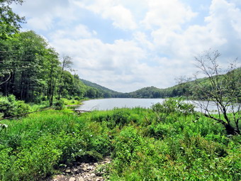 I took a few shots from the top of the climb and then Bryce and I looked for a way to get down to the streambed. I let myself down one level and took a few shots. I worked my way down to the streambed with Bryce and Sheena right behind. I took pictures of the falls from that angle and I also took pictures downstream toward the top of the lower falls. The remains of the dam that had been placed here to control the flow of the stream was clearly visible. I finished taking pictures and we climbed back up to the upper level where I stowed my camera. We walked down the path and back out to the main trail. At the main trail we turned right and then left where the trail split. We started out on the Mud Pond Trail crossing the outlet stream from Trout Pond on the bridge. There was very little water flowing in the stream from the outlet to Trout Pond. As we passed by the large campsite on the right, we noted that no one was camped. I was surprised since this is one of the most popular campsites. The trail began to climb the hill and in .6 miles we gained over 350 feet. Along the way we removed some loose branches and moved at least one trunk to the side of the trail. The climb is a little steep at times so moving the branches and blowdowns gave me a couple of breaks. There are several streams that run across the trail and all were almost dry. The trail itself was dry and extremely rocky which made walking difficult. Soon we were at the top of the hill and began a slight descent toward the trail junction. The trail remained dry even in places that were normally wet. When we reached the trail junction, we turned right on the Mud Pond Trail and began a long climb. There were numerous locations where there were large trees across the trail and others were large branches had fallen and were blocking the trail. As we walked, the skies began to grow darker a little darker but no rain fell. The trail continued to be very dry with many small branches that came down in recent winds. The climb seemed to go on for a long time and when we got to the top I was glad the rest of the hike was downhill or flat.
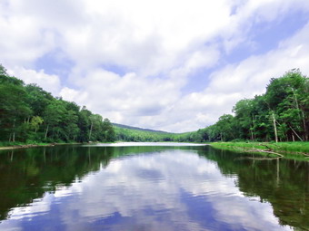 As we began our descent, we continued to find trees across the trail and we needed to walk around them and then back to the trail. The descent from the highest point on the hike to the outlet bridge is .7 miles and loses 455 feet in elevation. The trail is rocky but I can normally make good time on the descent. On the final descent to the pond, we made a slight right turn to start down to the pond. We arrived at the outlet end of the pond where we started across the bridge but stopped to take some pictures. I took pictures of the inlet stream that was completely dry. I took shots of Bryce and Sheena standing on the bridge. I also took shots of the lake with different zooms and at different angles. We continued across the bridge over the inlet stream and started toward the outlet end of the pond. We found the large campsite on the left of the trail unused. At one point there was a place to walk off the trail to take some pictures of the pond but I decided we would continue to the "beach" at the end of the lake. We continued down the trail and stopped at the beach to take pictures. The pond was low enough so that there was at least 10 feet of beach and no water was going over the spillway! Sheena got a drink and waded in the water but chose not to swim. I took a number of pictures of the lake, the spillway and the beach. I also snapped a couple of shots of Bryce and Sheena on the beach. We continued on the main trail setting a rapid pace as this part of the trail has less rocks. The trail descends gently losing 260 feet over .7 miles on a wide woods road. We passed the junction with the Mud Pond Trail and walked by the trail register as we continued on the trail and back to the car. We arrived at 1:15 PM after walking 4.6 miles in 2 hours and 50 minutes. The elevation gain was about 926 feet. The temperature at the car was 85 degrees!
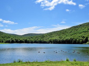
![]()
![]()
![]()
![]()
![]() On Friday, July 18th, I wanted to get out and do a longer hike as I had a crew covering ambulance calls. I thought about going to Balsam Lake Mountain as I had not hiked a mountain in some time. In the end I changed my mind as the drive to Balsam Lake Mountain was too long and I thought I might not be in shape to enjoy it. I knew Sheena didn't care as long as we were outside. I asked Cindy if she would like to go to Trout Pond but she countered with Alder Lake. I knew that she would not be able to go too far as she was still building up her strength so I thought Alder Lake would be fine. We could hike toward the beaver ponds and turn around when she grew tired. We started to get ready at 9:30 AM with the temperature at 68 degrees and plenty of sun and blue skies. Sheena was hovering around me as she can always detect when I am getting ready for a hike. I decided to wear a new Columbia Omni-Shade Omni-Wick crew shirt without a baselayer. I wore my Railriders hiking pants which are expensive but last along time and have features like deep pockets and a generous cut which I really like. The pants have Velcro closures at the ankles. I thought about warmer pants but decided against it. I decided to put on my Keen Durand hiking boots which fit well. I added a new pair of Xstance insoles in an effort to find the best support and cushioning for my feet. These insoles have shock absorbing gel pads, TPU arch support, and memory foam cushioning all wrapped in a breathable fabric. The insoles have been hyped by their manufacturer and seemed to be living up to their claims. I grabbed a pair of Leki Makalu Lite poles I have been using for some time because they are light and lock without slipping. I put on my OR BugOut gaiters as I knew the trail might be wet and muddy from the recent rains. These gaiters also help to ward off ticks. I also decided to wear my Or floppy hat. I put our gear in the car and Sheena in the backseat and we left Livingston Manor at 9:50 AM and drove north and west on Old Route 17 toward Roscoe. Just outside of town I turned right on the Beaverkill Road and headed north. I continued on the Beaverkill Road through Lew Beach and Turnwood toward Alder Creek Road where I made a left. I continued to the end on the road where I turned right toward Alder Lake. I drove up the access road very slowly as there are some very rough spots. When I got to the parking area it was almost filled with cars. A group had set up a table and looked like they might barbecue in the parking lot. The temperature was 72 degrees with sunny skies a a slight breeze. The skies were bright and sunny with lots of blue and some puffy white clouds. As I was about to let Sheena out of the car to begin the hike a man came walking by with his son and a rather aggressive dog tugging on the leash, I kept Sheena in the car until they had passed. The man turned around and asked if we knew the location of the campsites. I told hi that primitive campsites were scattered around the lake. He asked if this was Big Pond. I almost took a picture of him standing in fron to the sign that said Alder Lake! I gave him directions to Big Pond and he seemed to understand. I made sure Sheena's ecollar was turned on and then put her on her leash before letting her out of the car. It was 10:20 AM when we began the hike and the temperature was 72 degrees.
On Friday, July 18th, I wanted to get out and do a longer hike as I had a crew covering ambulance calls. I thought about going to Balsam Lake Mountain as I had not hiked a mountain in some time. In the end I changed my mind as the drive to Balsam Lake Mountain was too long and I thought I might not be in shape to enjoy it. I knew Sheena didn't care as long as we were outside. I asked Cindy if she would like to go to Trout Pond but she countered with Alder Lake. I knew that she would not be able to go too far as she was still building up her strength so I thought Alder Lake would be fine. We could hike toward the beaver ponds and turn around when she grew tired. We started to get ready at 9:30 AM with the temperature at 68 degrees and plenty of sun and blue skies. Sheena was hovering around me as she can always detect when I am getting ready for a hike. I decided to wear a new Columbia Omni-Shade Omni-Wick crew shirt without a baselayer. I wore my Railriders hiking pants which are expensive but last along time and have features like deep pockets and a generous cut which I really like. The pants have Velcro closures at the ankles. I thought about warmer pants but decided against it. I decided to put on my Keen Durand hiking boots which fit well. I added a new pair of Xstance insoles in an effort to find the best support and cushioning for my feet. These insoles have shock absorbing gel pads, TPU arch support, and memory foam cushioning all wrapped in a breathable fabric. The insoles have been hyped by their manufacturer and seemed to be living up to their claims. I grabbed a pair of Leki Makalu Lite poles I have been using for some time because they are light and lock without slipping. I put on my OR BugOut gaiters as I knew the trail might be wet and muddy from the recent rains. These gaiters also help to ward off ticks. I also decided to wear my Or floppy hat. I put our gear in the car and Sheena in the backseat and we left Livingston Manor at 9:50 AM and drove north and west on Old Route 17 toward Roscoe. Just outside of town I turned right on the Beaverkill Road and headed north. I continued on the Beaverkill Road through Lew Beach and Turnwood toward Alder Creek Road where I made a left. I continued to the end on the road where I turned right toward Alder Lake. I drove up the access road very slowly as there are some very rough spots. When I got to the parking area it was almost filled with cars. A group had set up a table and looked like they might barbecue in the parking lot. The temperature was 72 degrees with sunny skies a a slight breeze. The skies were bright and sunny with lots of blue and some puffy white clouds. As I was about to let Sheena out of the car to begin the hike a man came walking by with his son and a rather aggressive dog tugging on the leash, I kept Sheena in the car until they had passed. The man turned around and asked if we knew the location of the campsites. I told hi that primitive campsites were scattered around the lake. He asked if this was Big Pond. I almost took a picture of him standing in fron to the sign that said Alder Lake! I gave him directions to Big Pond and he seemed to understand. I made sure Sheena's ecollar was turned on and then put her on her leash before letting her out of the car. It was 10:20 AM when we began the hike and the temperature was 72 degrees.
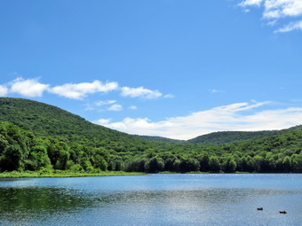 We walked along the path which passes by the stone foundations which marks the last remnants of the Coykendall Mansion. The house had been built as a large hunting lodge and then was gifted to the Boy Scouts of America. When the state took over the property, the mansion fell into disrepair with campers tearing boards away to use for campfires. The state added a fence but it did not deter people so the house was eventually burned to the ground. As we walked down the right side of the lawn, I noticed that the grass was short as if a DEC crew had mowed it recently. One of the big trees that had stood on the property for as long as I can remember had fallen and had not been removed. The picnic tables all had a crushed stone had beneath them and paths of the same material leading to them. This was an improvement over previous years and made the area more inviting. An Assistant Forest Ranger was sitting on one of the tables and we said "Hello" as we walked down the hill to the edge of the lake. There were a dozen or more geese in the water near shore and I was glad Sheena was on her leash. I took out my camera and snapped some shots of the lake and the hills around it including Millbrook Ridge and Cradle Rock Ridge. The sun was bright but was at a good angle so I could get some great shots. The sunlight bouncing off the lake was causing the ripples in the water to sparkle. While I was taking pictures, Sheena was tugging on her leash which I had handed over to Cindy. Sheena is now a little more than 1 year old and still has the energy of a puppy. The foot that she had cut a weak ago seemed to be healing but I noticed she would give a hop occasionally. I took Sheena's leash back and we walked across the lawn toward the trail around the left side of the lake and started walking east along the trail on the north side of the lake. The trail was wet in many places with a few muddy spots. The brush and branches that had been dead on my previous trip were now encroaching on the path making walking less than a pleasure. The small streams that cross the trail had quite a bit of water in them. Sheena was happy to be out and I let her off her leash so she could run ahead. After a certain distance she would return to us or wait until we could catch up. The trail pen up a little making the walking easier. We walked a little farther and I stopped for a moment to walk out to the edge of the lake to take some pictures of Cradle Rock Ridge on the other side of the lake. I took some shots and then returned the camera to my pack.
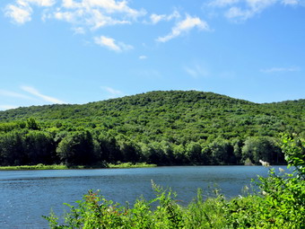 We continued on the trail and crossed the bridge on the trail near the head end of the lake. I could see the beaver dam that impounded some water from the inlet streams was still intact and that some gaps had been repaired making the water higher. I stopped to take pictures of the dam and the water behind it. The sun was at a good angle so I took several photos. We continued on the trail toward the junction with the Millbrook Ridge Trail. At the point where a path leads to the left to some primitive campsite, a large tree was across the trail still lying on the ground. We were able to step over it but it was not easy. The trail conferences have been having trouble getting volunteers to do the work. There was also a large tree down blocking access to some of the campsites. At the trail junction, we turned left to head toward the lean-to on the Millbrook Ridge Trail. The trail was wet in some places and muddy in quite a few areas. Fortunately, the trail showed more use than I had expected and the nettles which were plentiful were largely absent from the trail. I was surprised that many of Te small streams that cross the trail were all but dry. The trail was relatively clear of blowdowns and branches. There were also some older and rotten trunks still on the trail. I did find a few blowdowns that I had cut when I was the maintainer and there a few more that should be cut. We crossed some streams that run across the trail and were almost dry. Alder Creek had quite a bit of water and we could here it as it ran downstream over the rocks. The sunlight was sparkling off the water but the leaves on the trees blocked the views. Some of the large, older blowdowns which had been across the trail had been cleared. The trail is pretty obvious and the blazes easy to see in most places. For the next 1.5 miles the trail climbed and then leveled off several times. The elevation gain is several hundred feet but the grade is never more than 12% and averages around 6%. There isn't too much to see along the way but this day was very pleasant because of the temperature and my mood.
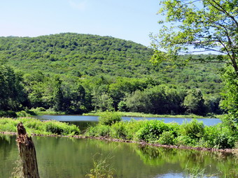 The trail leveled off at the first beaver meadow and I tried to walk out to take some pictures. The water was high and the area very marshy. Trees and bushes block the way and U decided not to try for any shots. At this point Cindy was pretty far behind and I decided this was as far as we would go. I really wanted us to get to the two beaver ponds so I could show her the new one but we would leave that for another day. I returned to the trail and we started back toward Alder Lake at 12:35 PM after hiking for 1 hour and 15 minutes including the stops for photography. Almost immediately a yung man came walking toward us and Sheena decided to say "Hello". He didn't seem to mind but I don't like to surprise people. He said he was headed to Millbrook Ridge to do some work and I thanked him for his service. I did wonder how much work he could get done as I saw that he had no tools. Sheena and I soon met Cindy who had some trouble climbing the hill. I knew she would be happier and we would make better time on the hike downhill to the lake. Cindy and I walked together down the hills which was much easier than the ascent. Sheena was way out in front as if the hike out had only increased her energy. As we approached the trail junction, we heard voices. We turned right onto the Alder Lake Trail and saw a couple of hikers ahead of us hike back toward the parking area. I assumed they had been hiking around the lake as we had not seen them in the Millbrook Ridge Trail. As we crossed the bridges, I heard Cindy excalim and looked around to see her lying on the bridge. heart jumped but it turned out to be a simple stumble. We continued on the trail toward the parking area. As we neared the lawn, I put Sheena back on her leash. We walked up the hill toward the ruins of the lodge and then toward the parking area. I decided I did not have enough time to walk down to Alder Creek to visit the waterfalls and I had done that on our last trip anyway. We were back at the car at 1:30 PM after hiking 4.0 miles in 2 hours and 1 minutes with plenty of stopped time for pictures. The return trip was 55 minutes or 20 minutes shorter than the time hiking out. The temperature has risen to almost 80 degrees and the parking area had even more cars. A big pickup towing a boat trailer came in as we were going out and I wondered where they would park.
![]()
![]()
![]()
![]()
![]() On Thursday, July 17th, it had been a week since Sheena had sliced a pad on her foot. We still don't know how. It was pretty extensive and bled quite a bit. Sheena is a tough little girl and did not seem to be bothered much. I had her checked by the vet and got an antibiotic. I waited until the foot looked better and decided it was time to hike. I planned take Sheena for a longer hike away from Livingston Manor as I had full ambulance coverage from 9:30 AM to 2:00 PM. Late I decided to go to the Parksville Rail Trail as it is close but interesting with a nice falls. I began to get ready at 11:30 AM with overcast skies and some sun. The Parksville Rail Trail is under three miles out and back but keeping a quick pace helps increase the difficulty. Sheena actually does get in about twice the mileage that I do as she forges ahead and then comes back to me! I have transitioned from using a leash all the time to using a GarmimSport PRO electronic collar which has many versatile settings and seems to do the job. This allows Sheena to roam and keeps me sane by not having to yank on her leash. It seems that Sheena likes hiking as she smells my clothes and then runs to sit by the door! I got dressed in a new Columbia Omni-Shade Omni-Wick shirt without a baselayer. I put on a pair of RailRiders hiking pants which are expensive but last a long time and have features like deep pockets and a generous cut which I really like. I thought about wearing a pair of low-cut and lighter hiking shoes but thought the trail might be wet and muddy. I decided to put on my Keen Durand hiking boots which fit well. I added a new pair of Xstance insoles in an effort to find the best support and cushioning for my feet. These insoles have shock absorbing gel pads, TPU arch support, and memory foam cushioning all wrapped in a breathable fabric. The insoles have been hyped by their manufacturer and seemed to be living up to their claims. I grabbed a pair of Leki Makalu Lite poles I have been using for some time because they are light and lock without slipping. I didn't bother to wear my OR floppy hat or gaiters. I also decided not to take my pack but to hike as fast as possible. I put our gear in the back of the car and Sheena in the back seat and we left Livingston Manor at 11:50 AM. Sheena has finally realized that she can easily jump in the back seat! I drove out Old Route 17 toward Parksville and turned left under the Quickway overpass onto Service Road. I drove toward Parksville and pulled into the parking area on the right side of the road just after Fox Mountain Rd. There were no cars parked in the lot when we arrived. I made sure Sheena's ecollar was adjusted correctly and then I let her out of the car at 11:00 AM. The temperature was 76 degrees and the sun made it feel warmer.
On Thursday, July 17th, it had been a week since Sheena had sliced a pad on her foot. We still don't know how. It was pretty extensive and bled quite a bit. Sheena is a tough little girl and did not seem to be bothered much. I had her checked by the vet and got an antibiotic. I waited until the foot looked better and decided it was time to hike. I planned take Sheena for a longer hike away from Livingston Manor as I had full ambulance coverage from 9:30 AM to 2:00 PM. Late I decided to go to the Parksville Rail Trail as it is close but interesting with a nice falls. I began to get ready at 11:30 AM with overcast skies and some sun. The Parksville Rail Trail is under three miles out and back but keeping a quick pace helps increase the difficulty. Sheena actually does get in about twice the mileage that I do as she forges ahead and then comes back to me! I have transitioned from using a leash all the time to using a GarmimSport PRO electronic collar which has many versatile settings and seems to do the job. This allows Sheena to roam and keeps me sane by not having to yank on her leash. It seems that Sheena likes hiking as she smells my clothes and then runs to sit by the door! I got dressed in a new Columbia Omni-Shade Omni-Wick shirt without a baselayer. I put on a pair of RailRiders hiking pants which are expensive but last a long time and have features like deep pockets and a generous cut which I really like. I thought about wearing a pair of low-cut and lighter hiking shoes but thought the trail might be wet and muddy. I decided to put on my Keen Durand hiking boots which fit well. I added a new pair of Xstance insoles in an effort to find the best support and cushioning for my feet. These insoles have shock absorbing gel pads, TPU arch support, and memory foam cushioning all wrapped in a breathable fabric. The insoles have been hyped by their manufacturer and seemed to be living up to their claims. I grabbed a pair of Leki Makalu Lite poles I have been using for some time because they are light and lock without slipping. I didn't bother to wear my OR floppy hat or gaiters. I also decided not to take my pack but to hike as fast as possible. I put our gear in the back of the car and Sheena in the back seat and we left Livingston Manor at 11:50 AM. Sheena has finally realized that she can easily jump in the back seat! I drove out Old Route 17 toward Parksville and turned left under the Quickway overpass onto Service Road. I drove toward Parksville and pulled into the parking area on the right side of the road just after Fox Mountain Rd. There were no cars parked in the lot when we arrived. I made sure Sheena's ecollar was adjusted correctly and then I let her out of the car at 11:00 AM. The temperature was 76 degrees and the sun made it feel warmer.
The first part of the trail was only damp as the sun had evaporated the rains that had fallen on and off in various recent storms. Off her leash Sheena would run ahead of me a certain distance and then maintain that distance by waiting for me or increasing her pace. We didm't get very far and I realized I had not brought a garbage to clean up the garbage at the falls. On my last trip there were over a dozen water bottles and other junk. I decided to walk back to the car and see if I had a bag in the car. Back at the car I found a garbage bag and stuffed it in my pocket. We started out again and were soon back under the cover of the trees. Once we were hiking on the trail, we were sheltered from the sun but I was still warm. The trail was wet with soft and muddy patches in all the usual spots. The gravel on the trail had been displaced indicating there had been a lot of water running on the trail. The trail runs parallel to the Little Beaverkill and the new section of State Route 17. It follows the route of the O&W railroad and is very flat. Sheena was setting a quick pace and I didn't mind as long as she would listen and wait for me when necessary. She did not seem to be favoring her injured paw or hopping on the other three legs. The water level in the stream was high than on our previous trip. Shortly after starting the hike I looked up to see a young woman hiking toward us with her dog. I took Sheena by the collar and attached her leash. We continued walking and met the woman who said "Hello". Sheena seemed interested in the other dog but was more interested in getting back to hiking. We continued on the trail through some muddy patches until we came to the viewpoint just before the wooden walkways. This spot has a nice view down to the stream and the skies were overcast. We walked across the wooden walkways which were damper and more slippery than on our last visit. The area before the bridge was only damp. Just after the bridge was a large patch of mud from one side of the trail to the other. The culvert under the bridge appeared permanently blocked and the water forms the mud. No one seems concerned about solving this problem. I walked around the mud to continue the hike but Sheena walked right through it. We came to the landslide that had brought down several trees that had been cut and cleared. This area is now muddy but there were some stepping stones. Sheena does not seem to mind sloshing through the water and wading through the mud. As we walked, we could hear the increase in noise from the stream. We reached the falls and I inspected them and found the water was a little higher than last time. There was also a new tree trunk in the lower falls. I did not go down to the streambed to see whether it added or subtracted from the scene. The garbage at the picnic table had been cleaned up which was encouraging.
We pushed on toward the other end of the trail continuing toward Parksville with Sheena in the lead pushing the pace. I did take a peek at the stream from the bench on the trail. I didn't find anything interesting so we pressed on! Within a few minutes, we were nearing the Parksville end of the trail and Sheena was eager to continue. We came to a spot in the trail where we could see the other side. The large dog that is often there was absent. We continued toward Parksville where the dogs near the end of the trail that had been absent during cold weather were no-shows on this hot day. We tagged the end of the trail when we reached the sign at the Parksville end of the rail trail. It was 11:31 AM and it had taken us 24 minutes to hike the length of the trail non-stop. We immediately turned around and started back toward the car. We set a fast pace back from the falls with Sheena in the lead. When we came to the bridge, I hopped around the mud while Sheena pushed through. We continued on the trail meeting the woman with her dog as we neared the end of the trail. As we approached the end of the trail, I called Sheena and told her "With" which is the equivalent of "Heel". We arrived back at the car at 11:54 AM after hiking over 2.7 miles in 48 minutes which was our record! The temperature had risen to 82 degrees. Sheena seemed fresh and could have hiked out and back on the trail another time as could I. We returned home and we both had something to drink. There had been no other ambulance calls while we were on the trail which made me feel good.
![]()
![]()
![]()
![]()
![]() On Wednesday, July 9th, I planned take Sheena for a longer hike away from Livingston Manor as I had full ambulance coverage from 9:30 AM to 2:00 PM. Late Tuesday night I found out that I would have to be at the building most of the morning so that the Stryker tech could work on some equipment. A company was also coming to give a quote for replacing our floor coating. I finally got home just after noon and decided I still wanted to get out. I decided to go to the Parksville Rail Trail as it is close but interesting with a nice falls. I began to get ready at 12:15 PM with blue skies and white clouds and plenty of sun. The Parksville Rail Trail is under three miles out and back but carrying a pack and keeping a quick pace helps increase the difficulty. Sheena actually does get in about twice the mileage that we do as she forges ahead and then comes back to us! I have transitioned from using a leash all the time to using a GarmimSport PRO electronic collar which has many versatile settings and seems to do the job. This allows Sheena to roam and keeps me sane by not having to yank on her leash. It seems that Sheena likes hiking as she smells my clothes and then runs to sit by the door! I got dressed in my White Sierra long-sleeved crew top without a baselayer. I put on a pair of RailRiders hiking pants which are expensive but last a long time and have features like deep pockets and a generous cut which I really like. I decided to put on my Keen Durand hiking boots which fit well. I added a new pair of Xstance insoles in an effort to find the best support and cushioning for my feet. These insoles have shock absorbing gel pads, TPU arch support, and memory foam cushioning all wrapped in a breathable fabric. The insoles have been hyped by their manufacturer and seemed to be living up to their claims. I grabbed a pair of Leki Makalu Lite poles I have been using for some time because they are light and lock without slipping. I put on my OR floppy hat but deiced nit to wear my gaiters. I also decided not to take my pack but to hike as fast as possible, I put our gear in the back of the car and Sheena in the back seat and we left Livingston Manor at 12:35 PM. Sheena has finally realized that she can easily jump in the back seat! I drove out Old Route 17 toward Parksville and turned left under the Quickway overpass onto Service Road. I drove toward Parksville and pulled into the parking area on the right side of the road just after Fox Mountain Rd. There were two cars parked in the lot when we arrived. I made sure Sheena's ecollar was adjusted correctly and then I let her out of the car at 12:45 PM. The temperature was 80 degrees and the sun made it feel warmer.
On Wednesday, July 9th, I planned take Sheena for a longer hike away from Livingston Manor as I had full ambulance coverage from 9:30 AM to 2:00 PM. Late Tuesday night I found out that I would have to be at the building most of the morning so that the Stryker tech could work on some equipment. A company was also coming to give a quote for replacing our floor coating. I finally got home just after noon and decided I still wanted to get out. I decided to go to the Parksville Rail Trail as it is close but interesting with a nice falls. I began to get ready at 12:15 PM with blue skies and white clouds and plenty of sun. The Parksville Rail Trail is under three miles out and back but carrying a pack and keeping a quick pace helps increase the difficulty. Sheena actually does get in about twice the mileage that we do as she forges ahead and then comes back to us! I have transitioned from using a leash all the time to using a GarmimSport PRO electronic collar which has many versatile settings and seems to do the job. This allows Sheena to roam and keeps me sane by not having to yank on her leash. It seems that Sheena likes hiking as she smells my clothes and then runs to sit by the door! I got dressed in my White Sierra long-sleeved crew top without a baselayer. I put on a pair of RailRiders hiking pants which are expensive but last a long time and have features like deep pockets and a generous cut which I really like. I decided to put on my Keen Durand hiking boots which fit well. I added a new pair of Xstance insoles in an effort to find the best support and cushioning for my feet. These insoles have shock absorbing gel pads, TPU arch support, and memory foam cushioning all wrapped in a breathable fabric. The insoles have been hyped by their manufacturer and seemed to be living up to their claims. I grabbed a pair of Leki Makalu Lite poles I have been using for some time because they are light and lock without slipping. I put on my OR floppy hat but deiced nit to wear my gaiters. I also decided not to take my pack but to hike as fast as possible, I put our gear in the back of the car and Sheena in the back seat and we left Livingston Manor at 12:35 PM. Sheena has finally realized that she can easily jump in the back seat! I drove out Old Route 17 toward Parksville and turned left under the Quickway overpass onto Service Road. I drove toward Parksville and pulled into the parking area on the right side of the road just after Fox Mountain Rd. There were two cars parked in the lot when we arrived. I made sure Sheena's ecollar was adjusted correctly and then I let her out of the car at 12:45 PM. The temperature was 80 degrees and the sun made it feel warmer.
The first part of the trail was dry as the sun had evaporated the rains that had fallen overnight. Off her leash Sheena would run ahead of me a certain distance and then maintain that distance by waiting for me or increasing her pace. Once we were on the trail, we were sheltered from the sun but I was still warm. The trail was mostly damp with soft and muddy patches in all the usual spots. The gravel on the trail had been displaced indicating there had been a lot of water running on the trail. The trail runs parallel to the Little Beaverkill and the new section of State Route 17. It follows the route of the O&W railroad and is very flat. Sheena was setting a quick pace and I didn't mind as long as she would listen and wait for me when necessary. The water level in the stream was the same as on our previous trip. Shortly after starting the hike I looked up to see an older man and woman walking toward us. I took Sheena by the collar and stepped off the side of the trail until they passed. We continued on the trail through some muddy patches until we came to the viewpoint just before the wooden walkways. This spot has a nice view down to the stream and the skies were blue with white clouds. We walked across the wooden walkways which were drier and less slippery than on our last visit. The area before the bridge was only damp. Just after the bridge was a large patch of mud from one side of the trail to the other. The culvert under the bridge appeared permanently blocked and the water forms the mud. No one seems concerned about solving this problem. I walked around the mud to continue the hike but Sheena walked right through it. We came to the landslide that had brought down several trees that had been cut and cleared. This area is now muddy but there were some stepping stones. Sheena does not seem to mind sloshing through the water and wading through the mud. As we walked, we could hear the increase in noise from the stream. We reached the falls and I inspected them and found the water was a little lower than last time. Unfortunately, the picnic table was littered with water bottles that someone found easier to leave behind than to carry out! The Town of Liberty has OT supplied and garbage receptacles on the trail which encourages this behavior. I picked up five bottles to carry to the Parksville end of the trail.
We pushed on toward the other end of the trail continuing toward Parksville with Sheena in the lead pushing the pace. I did take a peek at the stream from the bench on the trail. I didn't find anything interesting but I did find half a dozen more bottles! Within a few minutes, we were nearing the Parksville end of the trail and Sheena was eager to continue. We came to a spot in the trail where we could see the other side. The large dog that is often there was absent. We continued toward Parksville where the dogs near the end of the trail that had been absent during cold weather were now out in full force. This time Sheena did not seem scared and continued to the end of the trail. We tagged the end of the trail when we reached the sign at the Parksville end of the rail trail. It was 1:10 PM and it had taken us 25 minutes to hike the length of the trail non-stop. We immediately turned around and started back toward the car. When we came to the bench with the water bottles, I picked them all up and drop them at the picnic table. We set a fast pace back from the falls led by Sheena. When we came to the bridge, I hopped around the mud while Sheena pushed through. We continued on the trail meeting the older man and woman as we neared the end of the trail. As we approached the end of the trail, I called Sheena and told her "With" which is the equivalent of "Heel". We arrived back at the car at 1:35 PM after hiking over 2.7 miles in 50 minutes which was probably our record! The temperature had risen to 82 degrees. Sheena seemed fresh and could have hiked out and back on the trail another time. We returned home and we both had something to drink. There had been no other ambulance calls while we were on the trail which made me feel good.
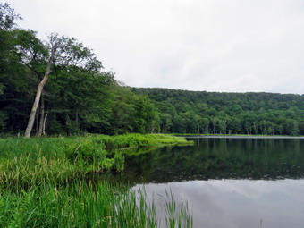
![]()
![]()
![]()
![]()
![]() On Monday, July 7th I had planned to get out and do a hike I had not done in some time. The day looked beautiful and I asked Cindy if she wanted to go for a walk. She agreed and I waited for her to get ready. When she came downstairs she announced she was not interested and that Sheena and I should go. I have learned not to try to persuade her so I swallowed my disappointment and started to get ready at 10:00 Am. I had full ambulance coverage until 2:00 PM and decided I would go to Huggins Lake where I had not been in over a year! This hike is about 4 miles and is always deserted. There is a long uphill stretch at the beginning and a shorter, steeper descent to the lake. The forecast was for thunderstorms around 1:00 PM but I thought we would be home before that. I began to get ready at 10:00 AM when the temperature was 80 degrees on the back porch and the humidity was 75%. As soon as I started to get ready, Sheena began to run around and whine anticipating getting out of the house. I got dressed in my White Sierra light crew top without a baselayer. I wore my Railriders hiking pants which are expensive but last along time and have features like deep pockets and a generous cut which I really like. The pants have Velcro closures at the ankles. I decided to put on my Keen Durand hiking boots which I ordered a half size larger than the previous pair. These shoes fit well out of the box but get much tighter when I add a decent insole. Without the third party insole, by feet hurt from the lack of support. I added a new pair of Xstance insoles in an effort to find the best support and cushioning for my feet. These insoles have shock absorbing gel pads, TPU arch support, and memory foam cushioning all wrapped in a breathable fabric. The insoles have been hyped by their manufacturer and they really do seem to deliver. I decided to take my Leki MicroVario poles with external locks as the internal twist locks fail. I put on my OR Bugoff gaiters to combat the ticks which have been plentiful this year. At the last mounts I put on my OR floppy hiking hat which can act as a base for insect repellant. I got my gear in the car and Sheena in the backseat. We left Livingston Manor at 10:20 AM and drove north on Old Route 17. I turned right on the Beaverkill Road and left on Campsite Road. At the bottom of the hill I turned right and drove down to the campgrounds parking area and across the Beaverkill Covered Bridge. At the end of the road I turned right and followed Berry Brook Road to the trailhead for Huggins Lake. We arrived at the road to the parking area to find it very rough with a lot erosion. I decided to give it a try and was able to get to the parking lot. I was not surprised to find we were the only car in the parking lot. We started off at 10:40 AM by walking through the metal gate on the woods road. The sun had been in and out of a heavy overcast. The temperature was 80 degrees as we headed out on the wide woods road to the lake. The humidity was still high making everything feel "sticky". The hike isn't long, less than 4 miles, and the trail is maintained by the DEC and we saw a few blowdowns along the way that had been cleared. There were no new blowdowns to clear.
On Monday, July 7th I had planned to get out and do a hike I had not done in some time. The day looked beautiful and I asked Cindy if she wanted to go for a walk. She agreed and I waited for her to get ready. When she came downstairs she announced she was not interested and that Sheena and I should go. I have learned not to try to persuade her so I swallowed my disappointment and started to get ready at 10:00 Am. I had full ambulance coverage until 2:00 PM and decided I would go to Huggins Lake where I had not been in over a year! This hike is about 4 miles and is always deserted. There is a long uphill stretch at the beginning and a shorter, steeper descent to the lake. The forecast was for thunderstorms around 1:00 PM but I thought we would be home before that. I began to get ready at 10:00 AM when the temperature was 80 degrees on the back porch and the humidity was 75%. As soon as I started to get ready, Sheena began to run around and whine anticipating getting out of the house. I got dressed in my White Sierra light crew top without a baselayer. I wore my Railriders hiking pants which are expensive but last along time and have features like deep pockets and a generous cut which I really like. The pants have Velcro closures at the ankles. I decided to put on my Keen Durand hiking boots which I ordered a half size larger than the previous pair. These shoes fit well out of the box but get much tighter when I add a decent insole. Without the third party insole, by feet hurt from the lack of support. I added a new pair of Xstance insoles in an effort to find the best support and cushioning for my feet. These insoles have shock absorbing gel pads, TPU arch support, and memory foam cushioning all wrapped in a breathable fabric. The insoles have been hyped by their manufacturer and they really do seem to deliver. I decided to take my Leki MicroVario poles with external locks as the internal twist locks fail. I put on my OR Bugoff gaiters to combat the ticks which have been plentiful this year. At the last mounts I put on my OR floppy hiking hat which can act as a base for insect repellant. I got my gear in the car and Sheena in the backseat. We left Livingston Manor at 10:20 AM and drove north on Old Route 17. I turned right on the Beaverkill Road and left on Campsite Road. At the bottom of the hill I turned right and drove down to the campgrounds parking area and across the Beaverkill Covered Bridge. At the end of the road I turned right and followed Berry Brook Road to the trailhead for Huggins Lake. We arrived at the road to the parking area to find it very rough with a lot erosion. I decided to give it a try and was able to get to the parking lot. I was not surprised to find we were the only car in the parking lot. We started off at 10:40 AM by walking through the metal gate on the woods road. The sun had been in and out of a heavy overcast. The temperature was 80 degrees as we headed out on the wide woods road to the lake. The humidity was still high making everything feel "sticky". The hike isn't long, less than 4 miles, and the trail is maintained by the DEC and we saw a few blowdowns along the way that had been cleared. There were no new blowdowns to clear.
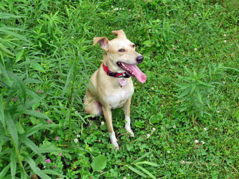 The first 1.2 miles is all uphill and gains almost 700 feet. Sheena was running up and down the trail following game paths into the woods. I often wonder how many miles she puts on as I plod along the trails. At times she would come back and check on me and then she was off again. I had feared long, wet grass on the trail but the grass was short and relatively dry. We did run into some patches of stinging nettles in the wetter spots. There was some mud but it was easy to get around them. The ascent has several spots which appear to be the top of the climb but are not. After the initial climb, the trail descends, levels some and then climbs again until the final descent to Huggins Lake. At one point a few drops of rain began to fall but stopped quickly. The rain was on and off all the way to the lake. There is a flat spot at the highest point which is about 20 feet long! As we continued, the trail made a sharp turn from southeast to north at about 1.6 miles. We enjoyed the downhill trek to the shores of the pond. There were also a few muddy spots that were easily navigated. I have found the maintenance on the woods road to be spotty at best. I knew we would soon have to turn around and climb back up the hill. When we arrived at the lake at 11:35 AM, I noticed that the water level was high and that rain was falling on the lake. I dropped my pack and got out my camera to take pictures of the lake. The sky was flat with almost no contrast and the predominant color in the forest was green. I took some pictures of the lake and the hills that surround it. At the outlet I could immediately see that the beavers had dammed the water flow and that reeds had grown to all but block the outlet flow. I thought Sheena might take a dip in the water but she stayed on dry ground. I took a few shots of Sheena sitting on the shore of the lake. I took a few more pictures of the lake before returning to my pack and stowing the camera. I packed up and started back up the hill at 11:40 AM. The only negative point about Huggins Lake is that there is only one trail and so there are no variations available. I had thought about bushwhacking around the lake but the ascent on the other side is very steep. The ascent on the woods road went smoothly for the most part as we climbed the hill back to the highest point on the trail. I wished Cindy was along for conversation and company but Sheena is entertaining. I let Sheena lead on the way back and sheet outpaced me at most times. The climb from the lake seemed easier than I remembered and we were soon at the highest point on the hike. The rain had all but stopped and nothing seemed wet. From the high point we started down the other side of the hill on the trail. Downhill was definitely easier than uphill! Sheena seemed very interested in following game trails off the main trail and I had to keep calling her back. From the highest point it was all downhill to the car. We arrived back at the car at 12:25 PM after hiking 4 miles in 1 hour and 45 minutes with a total elevation gain of 920 feet.
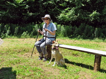
![]() On Friday, July 4th, I planned to take a longer hike away from Livingston Manor as I had a crew on to cover ambulance calls. I asked Cindy if she would like to go and she said "Yes". We discussed some options including the Bramley Fire Tower and the Catskill Rail Trail starting at Bloomville. In the end we decided to stay closer to home and hike at Trout Pond which has a nice waterfall. As we began to get ready at 9:30 AM the temperature was 76 degrees with sunny and almost cloudless skies. Sheena was keeping a close eye on me to make sure I did not accidentally forget her. I got dressed in my White Sierra long-sleeved crew top without a baselayer. I put on a pair of RailRiders hiking pants which are expensive but last a long time and have features like deep pockets and a generous cut which I really like. I decided to put on my Keen Durand hiking boots which fit well. I added a new pair of Xstance insoles in an effort to find the best support and cushioning for my feet. These insoles have shock absorbing gel pads, TPU arch support, and memory foam cushioning all wrapped in a breathable fabric. The insoles have been hyped by their manufacturer and seemed to be living up to their claims. I grabbed a pair of Leki Makalu Lite poles I have been using for some time because they are light and lock without slipping. I put on by OR wide-brimmed hat and searched for my OR BugOut gaiters. I found that Cindy was trying to be helpful and washed them which I never do. As we were about to leave the house, the ambulance pager sounded and I listed to see if my crew was responding. Both crew members called in almost immediately so we were free to continue with our plans. I put our gear in the back of the car and Sheena in the back seat and we left Livingston Manor at 10:00 AM. I got on State Route 17 and drove north and west toward Roscoe and got off at Exit 94. I turned left and continued through Roscoe and Rockland on Route 206 until just passed the Delaware County line. I turned left on Morton Hill Road and drove to the junction with Russell Brook Road. We had thought there might be a few campers at Trout Pond but t our dismay the private parking lot at the intersection was full. People park in this lots despite the signs and I know the owner does not like it. I secretly (oops!) Hope that he will call a towing company and have the cars removed. We decided that there would be too many people to make the hike enjoyable and we started to think of other destinations. Cindy almost immediately mentioned Bear Spring WMA near Walton. We had not been there in some time and there are hundreds of acres of land and many miles of trail. I agreed this was a good choice. I continued on Morton Hill Road to Campbell Mountain Road and Then Jug Tavern which took us back out to Route 206. I turned left to head towards Downsville. At the unction with Route 30 I turned left and drove into Downsville. The view from the dam was beautiful as we drove by. We stopped in Downsville for gas and then headed toward Walton on Route 206. Just short of East Trout Brook Road I turned into a large pulloff and parked the car. The temperature was 80 degrees and the sun made it feel warmer. There were no clouds in the sky which is not what I prefer for photography but it was still a beautiful day with a stiff breeze. I set my GPS and put Sheena on her leash for the short walk up the road to the woods road and trail.
On Friday, July 4th, I planned to take a longer hike away from Livingston Manor as I had a crew on to cover ambulance calls. I asked Cindy if she would like to go and she said "Yes". We discussed some options including the Bramley Fire Tower and the Catskill Rail Trail starting at Bloomville. In the end we decided to stay closer to home and hike at Trout Pond which has a nice waterfall. As we began to get ready at 9:30 AM the temperature was 76 degrees with sunny and almost cloudless skies. Sheena was keeping a close eye on me to make sure I did not accidentally forget her. I got dressed in my White Sierra long-sleeved crew top without a baselayer. I put on a pair of RailRiders hiking pants which are expensive but last a long time and have features like deep pockets and a generous cut which I really like. I decided to put on my Keen Durand hiking boots which fit well. I added a new pair of Xstance insoles in an effort to find the best support and cushioning for my feet. These insoles have shock absorbing gel pads, TPU arch support, and memory foam cushioning all wrapped in a breathable fabric. The insoles have been hyped by their manufacturer and seemed to be living up to their claims. I grabbed a pair of Leki Makalu Lite poles I have been using for some time because they are light and lock without slipping. I put on by OR wide-brimmed hat and searched for my OR BugOut gaiters. I found that Cindy was trying to be helpful and washed them which I never do. As we were about to leave the house, the ambulance pager sounded and I listed to see if my crew was responding. Both crew members called in almost immediately so we were free to continue with our plans. I put our gear in the back of the car and Sheena in the back seat and we left Livingston Manor at 10:00 AM. I got on State Route 17 and drove north and west toward Roscoe and got off at Exit 94. I turned left and continued through Roscoe and Rockland on Route 206 until just passed the Delaware County line. I turned left on Morton Hill Road and drove to the junction with Russell Brook Road. We had thought there might be a few campers at Trout Pond but t our dismay the private parking lot at the intersection was full. People park in this lots despite the signs and I know the owner does not like it. I secretly (oops!) Hope that he will call a towing company and have the cars removed. We decided that there would be too many people to make the hike enjoyable and we started to think of other destinations. Cindy almost immediately mentioned Bear Spring WMA near Walton. We had not been there in some time and there are hundreds of acres of land and many miles of trail. I agreed this was a good choice. I continued on Morton Hill Road to Campbell Mountain Road and Then Jug Tavern which took us back out to Route 206. I turned left to head towards Downsville. At the unction with Route 30 I turned left and drove into Downsville. The view from the dam was beautiful as we drove by. We stopped in Downsville for gas and then headed toward Walton on Route 206. Just short of East Trout Brook Road I turned into a large pulloff and parked the car. The temperature was 80 degrees and the sun made it feel warmer. There were no clouds in the sky which is not what I prefer for photography but it was still a beautiful day with a stiff breeze. I set my GPS and put Sheena on her leash for the short walk up the road to the woods road and trail.
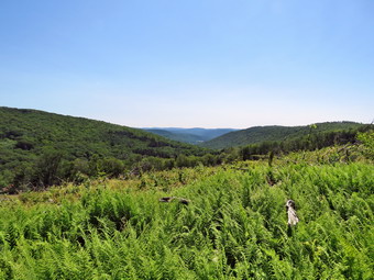 We turned left onto a woods road, one of many that run through the area. We walked around the gate and came to a sign cautioning us that there was logging in the area. We decided that there would be no logging on the 4th of July so we continued with caution. Not very far in we came to a wider, cleared area and found two wooden benches and a sign. The sign explained the reason for clear-cutting forests to get rid of older trees of one kind. This allows more diversity of trees and bushes which, in turn, supports more species of animals. I took some shots of the benches and the sign. I also took some pictures of Cindy and Sheena standing and sitting on the benches. We left the benches and continued on the road which was bounded on both sides by trees. The trees on the left we younger than on the right. The area on the left had been through a clear-cut less than ten years ago but was recovering very quickly. The trail rolled up and won a little and I was surprised we had not come to an open view that I remembered. Cindy suggested that the viewpoint should be up ahead and we soon came to the new clear-cut that was being logged. No one was working and there were no machines around. We were relatively sure the logging had ended so we proceeded with caution. We walked to a higher point along the trail and I took out my camera. I took shots of the view of the valley made available by the clear-cut. There were no clouds in a flat blue sky and there was some haze hanging over the valley but the scene was still pretty. I took some more shots of the road both ahead and behind us. I also took pictures of the mess left behind by the clear-cut including a lot of potential firewood. I know that the mess will encourage new growth but for now it is not a pretty sight. There were a few lone trees that remained standing and I photographed them against the flat sky. We walked a little farther on the trail and I took a few more shots from different angles. When I was done, I put the camera away and continued on the trail entering the woods.
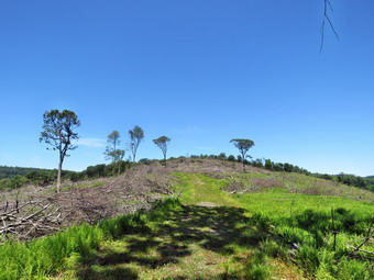 Over the next half mile the trail began to gain some elevation but only about 130 feet at a 6% grade. We were walking in the shade with a lovely breeze so hiking was very comfortable. There continued to be a few muddy spots which we easily avoided but which attracted Sheena. There were also very obvious track marks from logging equipment and I was anxious to see if there was another area that had been logged. I was trying to take it slow but was getting ahead of Cindy at times. Sheena was outpacing both of us by running ahead of us and then running back to us over and over again. We came to a series of small ascents and Cindy indicated she would have to turn around soon. We got a drink and started up again. I decided to hike faster and make it to a trail junction before turning around and starting back. Sheena and I forged ahead and at 2 miles made it to the trail that leads to a parking area on East Trout Brook Road just south of Launt Pond. It was 12:40 when we turned around and started back to the car. I had wanted to hike further but understood that Cindy should not go any further. It wasn't long until we met Cindy hiking toward us. We turned around and started back downhill at a good pace. We had not met any other hikers which was the reason we picked this area. We broke out of the forest into the open of the clear-cut and found three hikers coming toward us. I put Sheena on her leash. As we passed the other hikers we exchanged greetings and they comment on Sheena being well-behaved and pretty. After we passed, I took Sheena off her leash. Within moments we encountered two more hikers, so I put Sheena back on her leash until we had passed the two women. We walked to the end of the clear-cut and started up a small hill. We met a couple hiking along the trail and I repeated the use of the leash. We were soon at the benches with the sign. We passed through the gate and walked back to the car. The temperature was 80 degrees but it felt warmer. We were back at the car at 1:30 PM after hiking 4 miles in 1 hour and 52 minutes for a moving average speed of 2.4 miles per hour which satisfied me. I want to return to the area as there are so many variations in hiking routes.
![]()
![]()
![]()
![]()
![]() On Thursday, July 3rd, I planned take Sheena for a hike but thought I would have to stick to Round Top as I was on call for the ambulance. I made a hone call and found a driver to cover for me which meant we could get out of Livingston Manor. It also meant I could leave my phone behind and really enjoy the hike. I asked Cindy to go hiking with us but for some reason she declined! I decided to go to the Parksville Rail Trail as it is close but interesting with a nice falls. I began to get ready at 12:15 PM with blue skies and white clouds and plenty of sun. The Parksville Rail Trail is under three miles out and back but carrying a pack and keeping a quick pace helps increase the difficulty. The last time I took Sheena on this hike, I had the feeling that she could have done it again when we got back to the car. She actually does get in about twice the mileage that we do as she forges ahead and then comes back to us! I have transitioned from using a leash all the time to using a GarmimSport PRO electronic collar which has many versatile settings and seems to do the job. This allows Sheena to roam and keeps me sane by not having to yank on her leash. It seems that Sheena likes hiking as she smells my clothes and then runs to sit by the door! I got dressed in my White Sierra long-sleeved crew top without a baselayer. I put on a pair of RailRiders hiking pants which are expensive but last a long time and have features like deep pockets and a generous cut which I really like. I decided to put on my Keen Durand hiking boots which fit well. I added a new pair of Xstance insoles in an effort to find the best support and cushioning for my feet. These insoles have shock absorbing gel pads, TPU arch support, and memory foam cushioning all wrapped in a breathable fabric. The insoles have been hyped by their manufacturer and seemed to be living up to their claims. I grabbed a pair of Leki Makalu Lite poles I have been using for some time because they are light and lock without slipping. I put our gear in the back of the car and Sheena in the back seat and we left Livingston Manor at 12:35 PM. Sheena has finally realized that she can easily jump in the back seat! I drove out Old Route 17 toward Parksville and turned left under the Quickway overpass onto Service Road. I drove toward Parksville and pulled into the parking area on the right side of the road just after Fox Mountain Rd. There were two cars parked in the lot when we arrived. I made sure Sheena's ecollar was adjusted correctly and then I let her out of the car at 12:45 PM. The temperature was 80 degrees and the sun made it feel warmer.
On Thursday, July 3rd, I planned take Sheena for a hike but thought I would have to stick to Round Top as I was on call for the ambulance. I made a hone call and found a driver to cover for me which meant we could get out of Livingston Manor. It also meant I could leave my phone behind and really enjoy the hike. I asked Cindy to go hiking with us but for some reason she declined! I decided to go to the Parksville Rail Trail as it is close but interesting with a nice falls. I began to get ready at 12:15 PM with blue skies and white clouds and plenty of sun. The Parksville Rail Trail is under three miles out and back but carrying a pack and keeping a quick pace helps increase the difficulty. The last time I took Sheena on this hike, I had the feeling that she could have done it again when we got back to the car. She actually does get in about twice the mileage that we do as she forges ahead and then comes back to us! I have transitioned from using a leash all the time to using a GarmimSport PRO electronic collar which has many versatile settings and seems to do the job. This allows Sheena to roam and keeps me sane by not having to yank on her leash. It seems that Sheena likes hiking as she smells my clothes and then runs to sit by the door! I got dressed in my White Sierra long-sleeved crew top without a baselayer. I put on a pair of RailRiders hiking pants which are expensive but last a long time and have features like deep pockets and a generous cut which I really like. I decided to put on my Keen Durand hiking boots which fit well. I added a new pair of Xstance insoles in an effort to find the best support and cushioning for my feet. These insoles have shock absorbing gel pads, TPU arch support, and memory foam cushioning all wrapped in a breathable fabric. The insoles have been hyped by their manufacturer and seemed to be living up to their claims. I grabbed a pair of Leki Makalu Lite poles I have been using for some time because they are light and lock without slipping. I put our gear in the back of the car and Sheena in the back seat and we left Livingston Manor at 12:35 PM. Sheena has finally realized that she can easily jump in the back seat! I drove out Old Route 17 toward Parksville and turned left under the Quickway overpass onto Service Road. I drove toward Parksville and pulled into the parking area on the right side of the road just after Fox Mountain Rd. There were two cars parked in the lot when we arrived. I made sure Sheena's ecollar was adjusted correctly and then I let her out of the car at 12:45 PM. The temperature was 80 degrees and the sun made it feel warmer.
The first part of the trail was dry as the sun had evaporated the rains that had fallen during the previous week. Off her leash Sheena would run ahead of me a certain distance and then maintain that distance by waiting for me or increasing her pace. Once we were on the trail, we were sheltered from the sun but I was still warm. The trail was mostly damp with soft and muddy patches in all the usual spots. The trail runs parallel to the Little Beaverkill and the new section of State Route 17. It follows the route of the O&W railroad and is very flat. Sheena was setting a quick pace and I didn't mind as long as she would listen and wait for me when necessary. The water level in the stream was lower than our previous trip. We continued on the trail through some muddy patches until we came to the viewpoint just before the wooden walkways. This spot has a nice view down to the stream and the skies were blue with white clouds. I decided to stop and take some shots even though the viewpoint had grown in a lot since our last hike. After taking a few shots, I turned to take some pictures of the rock cut along the rail trail. I then posed Sheena at the beginning of the wooden bridge and took a few pictures. We walked across the wooden walkways which were drier and less slippery than on our last visit. The area before the bridge was only damp. Just after the bridge was a large patch of mud from one side of the trail to the other. The culvert under the bridge appeared permanently blocked and the water forms the mud. No one seems concerned about solving this problem. I walked around the mud to continue the hike but Sheena walked right through it. We came to the landslide that had brought down several trees that had been cut and cleared. This area is now muddy but there were some stepping stones. Sheena does not seem to mind sloshing through the water and wading through the mud. As we walked, we could hear the increase in noise from the stream. We reached the falls and I inspected them and found the water was a little lower than last time. There were a no people wading below the falls so I decided to go down to take some pictures. Sheena and I walked down the dry path to the stream bed which was slipperier than I imagined. When I got to the stream, I put down my pack and got out the camera. I followed my usual procedure of taking some pictures of the falls at different zooms and angles. The sun was not quite as bright on the falls as last time which made for better pictures. I took some shots downstream and then posed Sheena on a rock in front of the falls. Sheena posed anxiously and I got a few pictures before she headed back up the path with me close behind. When we reached the trail, I took some photographs of the falls from above. I also took shots upstream of the falls and then packed up to continue the hike.
We pushed on toward the other end of the trail continuing toward Parksville with Sheena in the lead pushing the pace. I did take a peek at the stream from the bench on the trail. I didn't find anything interesting so we continued without stopping. Within a few minutes, we were nearing the Parksville end of the trail and Sheena was eager to continue. We came to a spot in the trail where we could see the other side. There was a large dog who was talking to Sheena with a loud voice. We continued toward Parksville where the dogs near the end of the trail that had been absent during cold weather were now out in full force. This time Sheena did not seem scared and continued to the end of the trail. We tagged the end of the trail when we reached the sign at the Parksville end of the rail trail. It was 1:22 PM and it had taken us 37 minutes to hike the length of the trail non-stop. We immediately turned around and started back toward the car. When we came to the rapids just before the falls, I decided that I was not going to stop to take any more pictures. We set a fast pace led by Sheena. I took a little time on the way back to train Sheena. I called her back to me and had her sit and stay. The stay part has gotten much better. When we came to the bridge, I hopped around the mud while Sheena pushed through. We continued on the trail but no other hikers. As we approached the end of the trail, I called Sheena and told her "With" which is the equivalent of "Heel". We arrived back at the car at 1:55 PM after hiking over 2.7 miles in 1 hour and 10 minutes. The temperature had risen to 82 degrees. Sheena seemed fresh and could have hiked out and back on the trail another time. I hope to try my theory on some longer hikes in the near future. We returned home and we all had something to drink. There had been no other ambulance calls while we were on the trail which made me feel good.
![]()
![]()
![]()
![]() On Tuesday, July 1st I planned to get out for a hike on Round Top with Sheena. She is a Feist-Cur cross which are actual types of dogs used on farms and for hunting in the south. She was estimated to weigh no more than 30 pounds but is already 49 pounds at 9 months. I was part of the ambulance coverage for the day but found an EMT to cover for me for an hour. I started to get ready to hike at 12:00 PM with the temperature at 76 degrees on the back porch. I got dressed in my Sierre long-sleeved crew top without a baselayer. I put on a pair of RailRiders hiking pants which are expensive but last a long time and have features like deep pockets and a generous cut which I really like. I decided to put on my Keen Durand hiking boots which fit well. I added a new pair of Xstance insoles in an effort to find the best support and cushioning for my feet. These insoles have shock absorbing gel pads, TPU arch support, and memory foam cushioning all wrapped in a breathable fabric. The insoles have been hyped by their manufacturer and seemed to be living up to their claims. I wore my OR Bugout gaiters to fight off the ticks that might be out. I took my Leki Makalu Light poles since I would be hiking with Sheena off leash for most of the hike. I put the ecollar on Sheena and turned it on. At 12:10 PM I put Sheena on her leash and we walked out the door to start the hike. We headed down the driveway and toward the street. Sheena has gotten used to walking on her leash to the end of the drive but sometimes gets nervous as we get near the road. This time she looked both ways and then looked at me and I said "OK" because there were no cars. She readily crossed the street and headed across the field. We walked to the back of the church and began the ascent of the steepest hill behind the church. Sheena had no problem walking up the hill except for the fact that she likes to stop and sniff very frequently. The hill is short but gets the circulation pumping and is the steepest and longest climb on the "trail." We did not stop on the way to the top of the hill and set a fast pace. Sheena is getting bigger every day and her pull on the leash is signficant. At the top we paused for a minute so I could look around at the hills that surround the hamlet of Livingston Manor. I also needed to catch my breath. The skies were a flat blue without any clouds. Sheena was eager to enter the woods on the trail and hopped right up the steps. The trail was dry with a lot of leaves.
On Tuesday, July 1st I planned to get out for a hike on Round Top with Sheena. She is a Feist-Cur cross which are actual types of dogs used on farms and for hunting in the south. She was estimated to weigh no more than 30 pounds but is already 49 pounds at 9 months. I was part of the ambulance coverage for the day but found an EMT to cover for me for an hour. I started to get ready to hike at 12:00 PM with the temperature at 76 degrees on the back porch. I got dressed in my Sierre long-sleeved crew top without a baselayer. I put on a pair of RailRiders hiking pants which are expensive but last a long time and have features like deep pockets and a generous cut which I really like. I decided to put on my Keen Durand hiking boots which fit well. I added a new pair of Xstance insoles in an effort to find the best support and cushioning for my feet. These insoles have shock absorbing gel pads, TPU arch support, and memory foam cushioning all wrapped in a breathable fabric. The insoles have been hyped by their manufacturer and seemed to be living up to their claims. I wore my OR Bugout gaiters to fight off the ticks that might be out. I took my Leki Makalu Light poles since I would be hiking with Sheena off leash for most of the hike. I put the ecollar on Sheena and turned it on. At 12:10 PM I put Sheena on her leash and we walked out the door to start the hike. We headed down the driveway and toward the street. Sheena has gotten used to walking on her leash to the end of the drive but sometimes gets nervous as we get near the road. This time she looked both ways and then looked at me and I said "OK" because there were no cars. She readily crossed the street and headed across the field. We walked to the back of the church and began the ascent of the steepest hill behind the church. Sheena had no problem walking up the hill except for the fact that she likes to stop and sniff very frequently. The hill is short but gets the circulation pumping and is the steepest and longest climb on the "trail." We did not stop on the way to the top of the hill and set a fast pace. Sheena is getting bigger every day and her pull on the leash is signficant. At the top we paused for a minute so I could look around at the hills that surround the hamlet of Livingston Manor. I also needed to catch my breath. The skies were a flat blue without any clouds. Sheena was eager to enter the woods on the trail and hopped right up the steps. The trail was dry with a lot of leaves.
As soon as we entered the woods, I took Sheena off her leash. We started on the trail with Sheena setting a good pace. Sheena was ranging ahead of me and taking some time to explore off the trail. At the first trail junction, we continued straight up the hill with Sheena leading the way. When we reached the top of the hill, we followed the yellow trail as it turned right. We walked uphill through the field of ferns that was full grown and very green. When we reached the "sitting rock", Sheena ignored it and continued to walk along the trail. We continued on the yellow trail up a small hill to the junction with the blue trail to the summit. I decided we would do a figure 8 so we turned right on the yellow trail. We followed the yellow trail along the base of Round Top with Sheena running ahead, waiting for me, and then running back. I did my best to keep up with her. At the next junction with the blue trail, we turned left and headed up toward the summit. Sheena showed no sign of slowing down as she ran up and down the trail. We passed over the highest point on the trail on public land and started down the other side. We bypassed the white crossover trail and turned left on the switchback in the blue trail. Sheena is getting very good at making the correct turns on the figure 8 pattern that we use. We walked out into the woods and turned almost 180 degrees to head back to the main blue trail. There was one large branch hanging into the trail and I knew I would have to bring a saw next time to clear it. I practiced giving Sheena commands so she will get used to obeying them. "With" makes her walk next to me near my heels. "Not too far" tells hers to wait for me until I am closer. "Come" makes her return to me and sit until I release her. On the main blue trail we turned left and headed down the main blue trail. At the junction with the yellow trail we turned left and walked along the base of Round Top. At the next junction with the blue trail we turned right and headed down the yellow trail. Where the trail meets the woods road, we turned right and continued downhill to the first trail junction. Sheena was in the lead for most of the hike and always seems to get the turns correct. The electronic collar has been working very well. Sheena had a lot of energy left so I decided to turn around and get in another figure 8 starting at 12:45 PM.
We turned around and walked up the woods road with Sheena pushing the pace. At the end of the woods road we turned left on the yellow trail and headed up to the first junction with the blue trail. We turned left on the yellow trail at the junction and walked along the base of Round Top to the next junction with the blue trail. Since Sheena was still interested in hiking, we turned right and headed up the blue trail toward the summit. We turned right on the switchback and headed out into the woods. We made the nearly 180 degree turn and headed back to the main blue trail. We turned right and bypassed the white crossover trail. We walked the blue trail to the summit and then started down the other side. When we came to the white trail we bypassed it and continued downhill to the junction with the yellow trail. We turned right and again walked along the base of Round Top. At the next trail junction, we turned left and headed toward the lookout. We continued downhill on the yellow trail and Sheena again bypassed the "Sitting Rocks". We walked on the yellow trail down to the viewpoint and continued to follow the trail as it turned left. Sheena still had tons of energy left and it was hard to stop her from trying to do zoomies and run off the trail into the woods. We started to descend the trail which was covered in a heavy layer of dead leaves. Sheena showed she still had a lot of energy left as she continued to run ahead and then double back. I decided to let her have her fun until we got to the first trail junction. We walked straight out to the trailhead where I put her back on the leash. We turned right to walk down the cemetery hill to the church parking lot. We walked through the parking lot to Rock Avenue. We walked across the road after we looked both ways. We were back at the house by 1:15 PM. We hiked for 1 hour and 5 minutes for over 2 miles of hiking. Sheena drank a lot of water and then laid down by me for a nap.
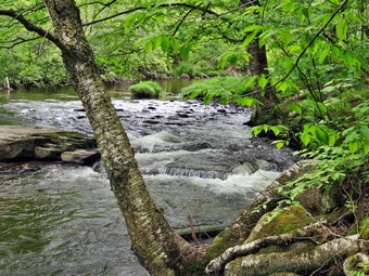
![]()
![]()
![]()
![]()
![]() On Sunday, June 29th, I planned take Sheena for a hike after church. When we returned home at noon I called another corps member who said they could cover until 2:00 PM. This meant we could get out of Livingston Manor and that I could leave my phone behind and really enjoy the hike. Sheena and I had not been out for over a week because Cindy and I had been away to celebrate our 50th wedding anniversary. I decided to encourage Cindy to go hiking with us. I suggested we go to the Parksville Rail Trail thinking that the falls would be roaring from the recent rains. I also knew that Cindy likes for a long time hikes and that she had not been hiking for months. She agreed so we began to get ready at 12:10 PM with blue skies and white clouds and plenty of sun. The Parksville Rail Trail is under three miles out and back but carrying a pack and keeping a quick pace helps increase the difficulty. The last time I took Sheena on this hike, I had the feeling that she could have done it again when we got back to the car. She actually does get in about twice the mileage that we do as she forges ahead and then comes back to us! Sheena has a wicked pull on her leash so I have transitioned to using a brand new GarmimSport PRO electronic collar which has many versatile settings and seems to do the job. This allows Sheena to roam and keeps me sane by not having to yank on her leash. As I got dressed, I remembered how much Sheila liked to hike this trail. It seems that Sheena likes hiking as she smells my clothes and then runs to sit by the door! I got dressed in my White Sierra long-sleeved crew top without a baselayer. I put on a pair of RailRiders hiking pants which are expensive but last a long time and have features like deep pockets and a generous cut which I really like. I decided to put on my Keen Durand hiking boots which fit well. I added a new pair of Xstance insoles in an effort to find the best support and cushioning for my feet. These insoles have shock absorbing gel pads, TPU arch support, and memory foam cushioning all wrapped in a breathable fabric. The insoles have been hyped by their manufacturer and seemed to be living up to their claims. I grabbed a pair of Leki Makalu Lite poles I have been using for some time because they are light and lock without slipping. I put our gear in the back of the car and Sheena in the back seat and we left Livingston Manor at 10:00 AM. For some reason Sheena will not jump in the back seat on the house unless I help her! I drove out Old Route 17 toward Parksville and turned left under the Quickway overpass onto Service Road. I drove toward Parksville and pulled into the parking area on the right side of the road just after Fox Mountain Rd. There were two cars parked in the lot when we arrived. I made sure Sheena's ecollar was adjusted correctly and then I let her out of the car. The temperature was 78 degrees and the sun made it feel warmer.
On Sunday, June 29th, I planned take Sheena for a hike after church. When we returned home at noon I called another corps member who said they could cover until 2:00 PM. This meant we could get out of Livingston Manor and that I could leave my phone behind and really enjoy the hike. Sheena and I had not been out for over a week because Cindy and I had been away to celebrate our 50th wedding anniversary. I decided to encourage Cindy to go hiking with us. I suggested we go to the Parksville Rail Trail thinking that the falls would be roaring from the recent rains. I also knew that Cindy likes for a long time hikes and that she had not been hiking for months. She agreed so we began to get ready at 12:10 PM with blue skies and white clouds and plenty of sun. The Parksville Rail Trail is under three miles out and back but carrying a pack and keeping a quick pace helps increase the difficulty. The last time I took Sheena on this hike, I had the feeling that she could have done it again when we got back to the car. She actually does get in about twice the mileage that we do as she forges ahead and then comes back to us! Sheena has a wicked pull on her leash so I have transitioned to using a brand new GarmimSport PRO electronic collar which has many versatile settings and seems to do the job. This allows Sheena to roam and keeps me sane by not having to yank on her leash. As I got dressed, I remembered how much Sheila liked to hike this trail. It seems that Sheena likes hiking as she smells my clothes and then runs to sit by the door! I got dressed in my White Sierra long-sleeved crew top without a baselayer. I put on a pair of RailRiders hiking pants which are expensive but last a long time and have features like deep pockets and a generous cut which I really like. I decided to put on my Keen Durand hiking boots which fit well. I added a new pair of Xstance insoles in an effort to find the best support and cushioning for my feet. These insoles have shock absorbing gel pads, TPU arch support, and memory foam cushioning all wrapped in a breathable fabric. The insoles have been hyped by their manufacturer and seemed to be living up to their claims. I grabbed a pair of Leki Makalu Lite poles I have been using for some time because they are light and lock without slipping. I put our gear in the back of the car and Sheena in the back seat and we left Livingston Manor at 10:00 AM. For some reason Sheena will not jump in the back seat on the house unless I help her! I drove out Old Route 17 toward Parksville and turned left under the Quickway overpass onto Service Road. I drove toward Parksville and pulled into the parking area on the right side of the road just after Fox Mountain Rd. There were two cars parked in the lot when we arrived. I made sure Sheena's ecollar was adjusted correctly and then I let her out of the car. The temperature was 78 degrees and the sun made it feel warmer.
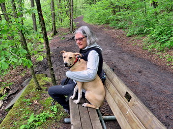 The first part of the trail was dry as the sun had evaporated the rains that had fallen during the previous week. Off her leash Sheena would run ahead of us a certain distance and then maintain that distance by waiting for us or increasing her pace. I did notice that the distance was shorter and she returned more often than on previous hikes. I could only attribute this to Cindy's presence. Once we were on the trail, we were sheltered from the sun but I was still warm. We almost immediately met a man and woman hiking toward us. I pulled Sheena off to the side of the trail and waited until the other hikers passed. Both said "Hello" and complemented Sheena. The trail was mostly damp with soft and muddy patches in all the usual spots. The trail runs parallel to the Little Beaverkill and the new section of State Route 17. It follows the route of the O&W railroad and is very flat. Sheena was setting a quick pace and I didn't mind as long as she would listen and wait for us when necessary. Cindy did not seem to be having any problems keeping up even though I would have been glad to wait. The water level in the stream was at the same level as our previous trip. We continued on the trail through some muddy patches until we came to the viewpoint just before the wooden walkways. This spot has a nice view down to the stream and the skies were blue with white clouds. I decided we would hike to the Parksville trailhead and take pictures on the way back. We walked across the wooden walkways which were drier and less slippery than on our last visit. The area before the bridge was only damp. Just after the bridge was a large patch of mud from one side of the trail to the other. The culvert under the bridge was still blocked and the water forms the mud. No one seems concerned about solving this problem. We walked around the mud to continue the hike. We came to the landslide that had brought down several trees that had been cut and cleared. This area is now muddy but there were some stepping stones. Sheena does not seem to mind sloshing through the water and wading through the mud. As we walked, we could hear the increase in noise from the stream. We reached the falls and I inspected them and found the water was high. There were a few people wading below the falls so we continued toward the end if the trail without stopping.
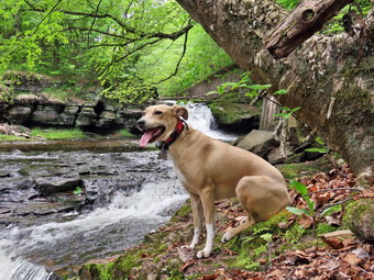 We pushed on toward the other end of the trail continuing toward Parksville with Sheena in the lead pushing the pace. I looked up to see two women ahead on the trail. Again I took Sheena to the side of the trail and waited until they walked by. We exchanged greetings and both women pronounced Sheena "a good dog." Within a few minutes, we were nearing the Parksville end of the trail and Sheena was eager to continue. We came to a spot in the trail where we could see the other side. A man that I had not seen before was playing with a large dog who was talking to Sheena with a loud voice. The dogs near the end of the trail that had been absent during cold weather were now out in full force. This time Sheena did not seem scared and continued to the end of the trail. We tagged the end of the trail when we reached the sign at the Parksville end of the rail trail. It was 1:22 PM and it had taken us 37 minutes to hike the length of the trail non-stop. We immediately turned around and started back toward the car. When we came to the rapids just before the falls, I decided that I was not going to stop to take pictures at all. I have hundreds of pictures of thralls and they don't vary much. IN addition, there were now more people at the falls! We set a fast pace led by Sheena and I was happy to see that Cindy was holding her won. I took a little time on the way back to train Sheena. I called her back to me and had her sit and stay. The stay part has gotten much better. When we came to the bridge, a father and his two sons came riding toward us on mountain bikes. They didn't seem very experienced and I did not know what they would do. I put Sheena on her leash as the three bikers walked their bikes through the mud. We continued on the trail and met the two women we had passed earlier. As we approached the end of the trail, I called Sheena and told her "With" which is the equivalent of "Heel". We arrived back at the car at 1:55 PM after hiking over 2.7 miles in 1 hour and 10 minutes because I did not stop to take pictures. The temperature had risen to 84 degrees. Sheena seemed fresh and could have hiked out and back on the trail another time. I hope to try my theory on some longer hikes in the near future. We returned home and we all had something to drink. There had been no other ambulance calls while we were on the trail which made me feel good.
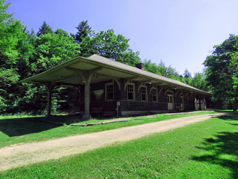
![]()
![]()
![]()
![]()
![]() On Tuesday, June 24th Cindy and I were staying at the Long Neck Inn at The Catskill Game Farm, a boutique hotel, in celebration of our 50th wedding anniversary. We had arrived Monday and walked around the grounds of the Game Farm in the 98 degrees heat. We planned to get up early the next morning and take a short hike before the heat caught up to us. We got up at 8:00 AM and tried to decide where to go. We considered a hike at Winter Clove but instead decided to do the Kaaterskill Rail Trail which I had never hiked. The trail goes from the Mountaintop Historical Society in Haines falls to the Laurel House Road parking area near Kaaterskill Falls. It is 1.5 miles long one way for a 3 mile round trip plus some walking around at the falls. I got dressed in a Columbia short-sleeved crew top without a baselayer. I put on a pair of RailRiders hiking pants which are expensive but last a long time and have features like deep pockets and a generous cut which I really like. I hoped that these pants would be warm enough once we got moving. I decided to put on my Keen Durand hiking boots which fit well. I added a new pair of Xstance insoles in an effort to find the best support and cushioning for my feet. These insoles have shock absorbing gel pads, TPU arch support, and memory foam cushioning all wrapped in a breathable fabric. The insoles have been hyped by their manufacturer and seemed to be living up to their claims. I took my Leki Makalu Light poles with external locks as the internal locks sometimes fail. We left the Inn at 8:30 AM and drove south and Route 32 to Route 23A. I turned right and headed west on Route 23A. We were soon Passing through Palenville and entering Kaaterskill Clove. There were quite a few people walking along the road and I was interested in seeing the parking situation in the Clove. As we drove through the Clove, there were only one or two cars parked under the "No Parking" signs and they looked very out of place. We continued through Haines Falls and stopped at Selena's Diner. We entered the diner and order breakfast from the attentive waitress. Cindy ordered eggs over easy and I got a Swiss cheese omelet. Both of our meals were delicious and the decaf coffee was great. The cost of the meal was reasonable and I would eat again there anytime.
On Tuesday, June 24th Cindy and I were staying at the Long Neck Inn at The Catskill Game Farm, a boutique hotel, in celebration of our 50th wedding anniversary. We had arrived Monday and walked around the grounds of the Game Farm in the 98 degrees heat. We planned to get up early the next morning and take a short hike before the heat caught up to us. We got up at 8:00 AM and tried to decide where to go. We considered a hike at Winter Clove but instead decided to do the Kaaterskill Rail Trail which I had never hiked. The trail goes from the Mountaintop Historical Society in Haines falls to the Laurel House Road parking area near Kaaterskill Falls. It is 1.5 miles long one way for a 3 mile round trip plus some walking around at the falls. I got dressed in a Columbia short-sleeved crew top without a baselayer. I put on a pair of RailRiders hiking pants which are expensive but last a long time and have features like deep pockets and a generous cut which I really like. I hoped that these pants would be warm enough once we got moving. I decided to put on my Keen Durand hiking boots which fit well. I added a new pair of Xstance insoles in an effort to find the best support and cushioning for my feet. These insoles have shock absorbing gel pads, TPU arch support, and memory foam cushioning all wrapped in a breathable fabric. The insoles have been hyped by their manufacturer and seemed to be living up to their claims. I took my Leki Makalu Light poles with external locks as the internal locks sometimes fail. We left the Inn at 8:30 AM and drove south and Route 32 to Route 23A. I turned right and headed west on Route 23A. We were soon Passing through Palenville and entering Kaaterskill Clove. There were quite a few people walking along the road and I was interested in seeing the parking situation in the Clove. As we drove through the Clove, there were only one or two cars parked under the "No Parking" signs and they looked very out of place. We continued through Haines Falls and stopped at Selena's Diner. We entered the diner and order breakfast from the attentive waitress. Cindy ordered eggs over easy and I got a Swiss cheese omelet. Both of our meals were delicious and the decaf coffee was great. The cost of the meal was reasonable and I would eat again there anytime.
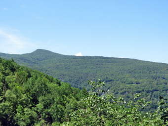 We left the diner and headed east on Route 23A to the Mountaintop Historical Society. I parked in the lot in back of the building where half a dozen cars had already parked. At 10:30 AM I set my GPS and we walked to the back of the lot toward the beginning of the rail trail. The temperature was already 88 degrees and it was getting warmer. Right at the beginning of the trail was the Haines Falls train station on the Ulster and Delaware Railroad. The station had been restored and looked to be in good shape. I stopped to take some pictures including some of the rails out front. We entered the trees and immediately we could feel the drop in temperature. I had read descriptions of the rail trail that described the great views of the Clove from the trail and I was anxious to see them. Like most rail trails this one was flat and straight so we both kept a fast pace. The trail bed started out dry and smooth running through alternating bands of evergreen and hardwood forest. At one point a trail turned 90 degrees to the left. There were some uprights that looked like they might support a sign but none was present. Soon the trail began to elevate slightly with swampy areas on either side. I kept looking for the beautiful views of the Clove. Another road crossed the trail but it was posted as private. The trail began to ascend ever so slightly and became more eroded with roots and rocks. We had been meeting single hikers are small groups all along the trail and all headed in the opposite direction. At 11:15 AM we had hiked 1.5 miles and were at the end of the rail trail. There had been no views from the trail!
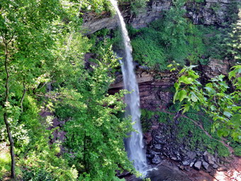 We made a quick right on the trails that go down to the viewing platform over the falls. There were a lot of people wandering around trying to decide which way to go. We walked downhill to the platform. There were only a few people on the platform. I put down my pack and got out my camera. As the platform cleared, I walked out and took some pictures of the upper falls. The flow was not as great as I thought it might be. There were people stretched out on the rocks at the bottom of the first drop and some were swimming next to the "No swimming" signs. We left the platform and followed the trail to an area near the top of the falls. The state has installed fences with signs warning people not to go beyond them. We could clearly see people out on the rocks, soaking in the water just above the falls, and walking around of the slippery rocks. On June 20, a 70 year-old man fell and succumbed to a head injury. He was pronounced dead at the trailhead. Despite numerous injuries and fatalities and despite the fences and the warnings, people still make stupid choices which, in many cases, are life-threatening. We continued around the trail to the bridge over the creek. I took some shots and we walked back up to the parking area. Near the parking area we could clearly see where the railroad bed continued toward North-South Lake Campgrounds. We turned left and started back toward the car on the railtrail. The return trip was all downhill even though there was not much of a descent. We kept up our pace and made it back to the car in 40 minutes. We had hiked 3.8 miles in 2 hours and 5 minutes. We had 21 minutes of stopped time and gained 400 feet in elevation. We drove back to the Inn and started to consider where we would eat. We ran into the same problem of many places being closed but we finally decided to try the Barnwood just north of Catskill. We arrived to find at least 50 cars in the parking lot. We decided we did not want to wait and made our way to the Ambrosia Diner in Catskill. The short story about the diner is that neither of us would go there to eat again!
![]() On Monday, June 23rd I had planned a two-day trip for our 50th wedding anniversary. This may not sound like much to some but we seldom get away but the members of the ambulance corps stepped up to cover all day and night shifts! I wanted the destination to be a surprise for Cindy until we arrived at our destination. Both of us enjoyed the Catskills Game Farm as kids. The Game Farm, a long-standing family-owned zoo in the Catskill Mountains, closed permanently in 2006 due to financial difficulties and declining attendance. After being abandoned for several years, the property was purchased in 2012. In 2019, the new owners renovated the Giraffe Barn into the Long Neck Inn with 6 bedrooms. The Inn also has a large common room with couches and chairs. There is also a kitchen with refrigerators and ranges for cooking. Dishes and silverware are also supplied. There is a coffee and tea station. The owners also added four glamping site on the property with elevated platforms and memory foam beds. I had reserved the Giraffe Room and was anxious to see it. For more information check out their website at The Old Game Farm.
On Monday, June 23rd I had planned a two-day trip for our 50th wedding anniversary. This may not sound like much to some but we seldom get away but the members of the ambulance corps stepped up to cover all day and night shifts! I wanted the destination to be a surprise for Cindy until we arrived at our destination. Both of us enjoyed the Catskills Game Farm as kids. The Game Farm, a long-standing family-owned zoo in the Catskill Mountains, closed permanently in 2006 due to financial difficulties and declining attendance. After being abandoned for several years, the property was purchased in 2012. In 2019, the new owners renovated the Giraffe Barn into the Long Neck Inn with 6 bedrooms. The Inn also has a large common room with couches and chairs. There is also a kitchen with refrigerators and ranges for cooking. Dishes and silverware are also supplied. There is a coffee and tea station. The owners also added four glamping site on the property with elevated platforms and memory foam beds. I had reserved the Giraffe Room and was anxious to see it. For more information check out their website at The Old Game Farm.
 On Monday morning we packed both casual and hiking clothing and left Livingston Mnaor at 10:00 AM. I drove to Liberty on Route 17 and headed toward Grahamsville on Route 55. We passed through Grahamsville headed toward Ellenville. At the junction with Route 209, I headed north toward Kingston. Traffic was light and we made good time. In Kingston, I got on the NYS Thruway north toward Saugerties. We exited at Saugerties and headed north on Route 32. It wasn't very far before things started to become familiar. I turned left on Game Farm Road which was rough and narrow with a single lane bridge repair! It was just the kind of road that I expected to lead to the Game Farm. We came to an old fire engine and a large parking area. At the far end was a gate with a keypad. I called Shawn, the caretaker, and he came down to open the gate and gave me the code for the keypad. We drove to the small parking area by the Long Neck Inn and parked. Even though it was only 11:45 AM, Shawn showed us into the Inn and gave us the padlock to our door. The common areas of the Inn were covered with pictures. memorabilia and original signs from the Game Farm. Cindy and I were dressed in our hiking clothes but decided to unload the car. Our room was the largest with a king bed, jacuzzi and TV. The bathroom had a shower with a wand and a rain shower head. The sides of the shower were galvanized metal. The doors of the rooms were all original with original hardware. Cindy and I both thought it was an interesting way to inject something new and keep a lot of the old. In the common room we were walking on the cement from the original barn and could see areas up very high where giraffes had rub their horns. For some reason I felt at home.
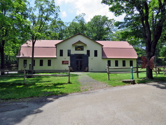 Once we had moved in, we decided to walk around the ruins of the Game Farm. There were plenty of paved pathway and over 200 acres available to explore. I shouldered my pack and we both had our hiking poles. The pack allows me to carry water and my camera. When we walked out the door of the Inn at 1:00 PM, the heat and humidity hit us. The temperature was 98 degrees which meant the "feels like" was well over 100 degrees. We walked out one of the paved pathways and I began taking pictures of all of the building. Most did not have signs indicating there previous use. We came to a small cage with perches and I seemed to remember some very large birds occupying it. We continued on the path with me continuing to take pictures. At one point we ran out of pavement and decided to turn around and follow the paved walkway. Soon we came to two large buildings each of which had a moat around them. I remembered that this is where the Rhinos and elephants were housed! I took lots of shots of the buildings and moats. We continued on the pathways making right turns so we knew we were making a loop. Eventually we started back up the hill toward the Inn. I was able to take some good shots of the front of the Inn. I also took pictures of the old refreshment building with some old cars and trucks. We also came to a pen on the right with some goats. I took some shots and watched the goats for awhile before moving on.
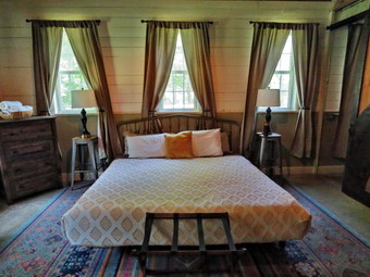 We retraced our steps to a junction and then turned left and headed to the upper level. There were more fences and building to photograph. We came to a large pond on the right covered in algae with some shelters built in the middle. I thought I could almost see the neat of an alligator poking above the water. We continued passing some more buildings which I made sure I photographed. I looked to the right and saw a large, flat ring down the hill with some grandstands nearby. I remembered that this was the ring where they gave shows with trained horses. There was a walkway that led back to the Inn but I continued passed it to look at some more dilapidated buildings. After taking pictures, I returned to the walkway where I joined Cindy and we walked downhill to the Inn. It was 2:30 PM and we were both tired and hot. We went to our room and took turns taking showers. I began to look for a place to eat but found many of them closed until at least Thursday and some that were only open on the weekends. This also meant that the places that were open are often crowded. We decided to try Arianny's a Mexican restaurant in Catskill which was less than 20 minutes away. We got in the car and pulled up to the gate but it did not open. I got out of the car and looked for a keypad but there was none. I took out my phone to call the caretaker. While walking around, I saw a sign on the shed near the gate that said "Pull up to the poodle, the gate will open".There was a statue of a poodle on the ground next to the shed. I got back in the car pulled up to the poodle and the gate opened.
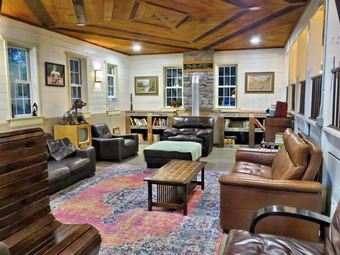 I drove to Catskill and eventually found Arianny's. The menu looked very complete. The service was great. We ordered an Arrianny's Platter as an appetizer to split. For $15 we got two empanadas, two chicken burritos, two quesadillas and two soft tacos. There was more than enough to make a meal! For the main course Cindy ordered an avocado salad with chicken. I decided on enchiladas with mole. I usually order mole and have both good and bad experiences. When the entrees arrived, we were both sure we would not be finishing them. Cindy made it clear that her salad was fresh and delicious. I tasted the mole and thought, at first, that it was not very hot until the heat hit on the back end. We ate what we could and asked for boxes to take home the rest. We left the restaurant agreeing that it would be worth a return trip if we were in the area again. I drove back to the Inn and parked with the temperature still over 90 degrees. We went to our room grateful for the air conditioning. Cindy was ready to go to sleep but I was not tired. I went out to the common room with the book I brought and read four chapters! At that point I was a little tired and went back to the room to get some sleep.
![]()
![]()
![]()
![]() On Friday, June 20th I was considering whether or not to hike because the weather forecast called for afternoon thunderstorms. We had an ambulance call just after midnight that was 33 miles from our base. When we arrived, the patient decided they did not want to go to the hospital! I did not get back to sleep until 3:00 AM so I slept until 10:00 AM. I did some work around the house and at the ambulance building. I hung around all day because I was the only EMT on call. At 3:30 PM the temperature was 78 degrees with bright sun, blue skies, and a significant number of clouds. Sheena was begging to go on a hike so I decided to take her. I was also motivated by the fact that it was the summer solstice and I wanted to get in the first hike of the summer in the place I visit the most. I was once again limited to Round Top as I was the only EMT on call for the ambulance corps. I knew I would have to carry my phone just in case a call came in. I got dressed in my light White Sierra long-sleeved crew top without a baselayer. I put on a pair of RailRiders hiking pants which are expensive but last a long time and have features like deep pockets and a generous cut which I really like. I hoped that these pants would be warm enough once we got moving. My toes were sore from hiking the day before but I decided to put on my Keen Durand hiking boots which fit well. I added a new pair of Xstance insoles in an effort to find the best support and cushioning for my feet. These insoles have shock absorbing gel pads, TPU arch support, and memory foam cushioning all wrapped in a breathable fabric. The insoles have been hyped by their manufacturer and seemed to be living up to their claims. I wore my OR Bugout gaiters to fight off the ticks that might be out. I took my Leki Makalu Light poles as I would be hiking with Sheena off leash for most of the hike. I put the ecollar on Sheena and turned it on. I decided not to put a harness on Sheena since she has been more well-behaved. At 4:00 PM I put Sheena on her leash and walked out the door to start the hike. We headed down the driveway and toward the street. Sheena has gotten used to walking on her leash to the end of the drive. She also has become accustomed to waiting for cars to pass by and then crossing when I say "OK". This time she looked both ways and then looked at me and I said "OK" because there were no cars. She readily crossed the street and across the field by the church. We walked behind the church and started up the hill on the paved road. Sheena gave me help up the hill by pulling on her leash. Sheena had no problem walking up the hill except for the fact that she likes to stop and sniff very frequently. The hill is short but gets the circulation pumping and is the steepest and longest climb on the "trail." We did not stop on the way to the top of the hill and set a fast pace. Sheena has grown bigger than we thought she would and her pull on the leash is signficant. At the top we paused briefly to look around before Sheena turned left and entered the forest trail. I immediately let Sheena off her leash and she started on the trail. She has been good about picking a certain distance on the trail and staying that far ahead of me. She does take some side trips to follow animal trails but comes back to the main trail.
On Friday, June 20th I was considering whether or not to hike because the weather forecast called for afternoon thunderstorms. We had an ambulance call just after midnight that was 33 miles from our base. When we arrived, the patient decided they did not want to go to the hospital! I did not get back to sleep until 3:00 AM so I slept until 10:00 AM. I did some work around the house and at the ambulance building. I hung around all day because I was the only EMT on call. At 3:30 PM the temperature was 78 degrees with bright sun, blue skies, and a significant number of clouds. Sheena was begging to go on a hike so I decided to take her. I was also motivated by the fact that it was the summer solstice and I wanted to get in the first hike of the summer in the place I visit the most. I was once again limited to Round Top as I was the only EMT on call for the ambulance corps. I knew I would have to carry my phone just in case a call came in. I got dressed in my light White Sierra long-sleeved crew top without a baselayer. I put on a pair of RailRiders hiking pants which are expensive but last a long time and have features like deep pockets and a generous cut which I really like. I hoped that these pants would be warm enough once we got moving. My toes were sore from hiking the day before but I decided to put on my Keen Durand hiking boots which fit well. I added a new pair of Xstance insoles in an effort to find the best support and cushioning for my feet. These insoles have shock absorbing gel pads, TPU arch support, and memory foam cushioning all wrapped in a breathable fabric. The insoles have been hyped by their manufacturer and seemed to be living up to their claims. I wore my OR Bugout gaiters to fight off the ticks that might be out. I took my Leki Makalu Light poles as I would be hiking with Sheena off leash for most of the hike. I put the ecollar on Sheena and turned it on. I decided not to put a harness on Sheena since she has been more well-behaved. At 4:00 PM I put Sheena on her leash and walked out the door to start the hike. We headed down the driveway and toward the street. Sheena has gotten used to walking on her leash to the end of the drive. She also has become accustomed to waiting for cars to pass by and then crossing when I say "OK". This time she looked both ways and then looked at me and I said "OK" because there were no cars. She readily crossed the street and across the field by the church. We walked behind the church and started up the hill on the paved road. Sheena gave me help up the hill by pulling on her leash. Sheena had no problem walking up the hill except for the fact that she likes to stop and sniff very frequently. The hill is short but gets the circulation pumping and is the steepest and longest climb on the "trail." We did not stop on the way to the top of the hill and set a fast pace. Sheena has grown bigger than we thought she would and her pull on the leash is signficant. At the top we paused briefly to look around before Sheena turned left and entered the forest trail. I immediately let Sheena off her leash and she started on the trail. She has been good about picking a certain distance on the trail and staying that far ahead of me. She does take some side trips to follow animal trails but comes back to the main trail.
We started on the trail with Sheena setting a good pace. The trail had no water or mud and was only slightly damp in places. At the first trail junction, Sheena turned right on the woods road which is the more gentle approach to the trail system. At the end of the woods road, we turned left and started up the trail to the junction with the blue trail. I decided I wanted to do a figure 8 so we turned left on the yellow trail which was the path Sheena had chosen. We walked along the base of Round Top. Sheena was running ahead and waiting or running back to me as fast as she could. At the next junction with the blue trail, we turned right and headed up the trail toward the summit. When we came to the switchback, Sheena turned right and we walked out into the forest. We followed the trail as it turned almost 180 degrees and headed back to the main trail. We turned right and started up over the summit passing by the white crossover trail. After passing over the summit, we started down the other side. Sheena kept running ahead but only just so far before waiting for me. I found that if she did not respond to my voice she did to the beeper in the ecollar. We bypassed the white crossover trail and continued down to the junction with the yellow trail. We turned right and again walked along the base of Round Top. We continued along the yellow trail turning left and continuing downhill on the yellow trail. We descended a small hill and passed by the "Sitting Rock" without Sheena giving it a second look. We followed the yellow trail down to the viewpoint and turned left to follow the trail as it turned left. I followed Sheena as she rushed down the steep hill to the first trail junction. Sheena made a slight turn onto the woods road as I stood for a moment at the junction. When I made a move to start up the hill again, Sheena immediately ran ahead of me up the hill.
We continued straight up the hill with Sheena leading the way on the trail with a few off trail excursions. Sheena was full of energy even though we had just completed a figure 8 but she only wanted to concentrate on hiking. We progressed up the hill with me following behind. At the upper lookout we followed the yellow trail as it turned right. Sheena and I continued on the trail. When we reached the "Sitting Rock", Sheena jumped up on it, looked around, and continued on the trail. We continued on the yellow trail up a small hill. There were quite a few small branches on the trail and some leaning in from the side. It was obvious that the rain over the previous week had caused all of the vegetation to go through a growth sprint. I knew I would have to reserve some time to trim the trail and repaint the blazes. When we reached the junction with the blue trail to the summit, we turned right to walk the yellow trail along the base of Round Top on our quest for another figure 8. We continued to the junction with the blue trail. We turned left and started up the blue trail toward the summit. I was beginning to notice that my legs were tired from hiking Touch-Me-Not Mountain on Thursday. We walked up the trail bypassing the white crossover trail. We continued over the summit of Round Top and started down the other side. It was a pleasure hiking without Sheena on a leash as it gave me the freedom to use my poles. We again bypassed the white crossover trail on the left but almost immediately turned left on the switchback. Once again it was out to the turn in the woods and then back to the main trail. We turned left and walked downhill to the junction with the yellow trail. When we reached the junction with the yellow trail, we turned left and walked along the yellow trail at the base of Round Top. We continued on the trail to the junction with the blue trail and turned right to stay on the yellow trail. At the end of the trail, we turned right on the woods road and walked downhill toward the first trail junction. As I was walking, I took a closer look at the rock ledges to the right of the trail. I noticed one rather large alcove that seemed carved out of the rock. There were several other "caves" formed from splits in the rock with a another rock as the roof. I decided this was not the day to explore but thought I might return some other time. At the first junction, we turned left to head out to the trailhead. I put Sheena on her leash and we turned right as we walked down the hill behind the church. We walked out the parking lot to the road and turned right on Rock Avenue and then left into the driveway. We were back at the house by 5:15 PM. We had hiked an hour and 15 minutes covering over 2 miles.