
What You Missed
Fall 2025
Fall 2025
![]()
![]()
![]()
![]()
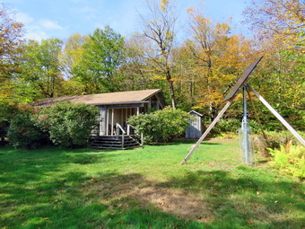
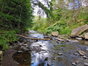
![]() On Thursday, October 2nd, I wanted to get out for a longer hike as I had missed hiking the first day of October and might miss tomorrow due to being on call for the ambulance corps. I had some things to do early in the morning which didn't bother me as the temperature was 32 degrees at 7:00 AM. I decided to go to Trout Pond and hike the loop in a clockwise direction with a short visit to Mud Pond. It was 46 degrees when I started to get ready at 9:15 AM. Sheena got wind of what was going on and began running around the house barking. I put on my long-sleeved Mammut crew top with no baselayer. I wore a pair of RailRiders hiking pants which are expensive but last a long time and have features like deep pockets and a generous cut which I really like. The pants have Velcro closures at the ankles. I decided to put on my Keen Durand hiking boots which fit well. I added a new pair of Xstance insoles in an effort to find the best support and cushioning for my feet. These insoles have shock absorbing gel pads, TPU arch support, and memory foam cushioning all wrapped in a breathable fabric. The insoles have been hyped by their manufacturer and seemed to be living up to their claims. I grabbed a pair of Leki Micro Vario poles I have been using for some time because they are light and lock without slipping. I donned my Mammut Hoody which has pitzips to dump heat as I new I could easily stow it in my pack. I put on a light hat and took along a pair of light gloves. I put my gear in the back and Sheena in the back seat. I headed to Roscoe at 9:30 AM on State Route 17, got off at exit 94 and got on Route 206. I followed it across the Delaware County line to Morton Hill Road. After a left turn on Morton Hill Road, I drove to the intersection with Russell Brook Road. For several years I had been parking at the lower parking area but this tome I decided to do a "legacy" hike. I turned around and parked on the side of the road to avoid the parking area which is private. There was already one car parked there an I know that the owners do not appreciate this. The NYNJTC maps have a gray P marking this area which means roadside parking only but many people cannot read map legends or do not care. I set my GPS and made sure Sheena's ecollar was on as we began our hike down Russell Brook Road at 9:55 AM. The temperature was 42 degrees but the sun was shining brightly which made it feel almost warm. Russell Brook Road was almost completely dry even though there had been some showers the previous week. As we walked along the road, I noticed that many of the leaves had already fallen and none of the colors were very bright. I had come to Trout Pond because I hoped for some nice fall colors and this was not a good start. The campsite on the left had a van parked and a chair set up by the fire pit but no one was around. We continued on down Russell Brook Road to the overlook over the upper falls. There was more water in the stream than my last visit but that wasn't saying much. We walked down to the overlook and I put down my pack and got out the camera. I took some shots and then packed up to continue the hike down toward the parking area where there were several cars already parked.
On Thursday, October 2nd, I wanted to get out for a longer hike as I had missed hiking the first day of October and might miss tomorrow due to being on call for the ambulance corps. I had some things to do early in the morning which didn't bother me as the temperature was 32 degrees at 7:00 AM. I decided to go to Trout Pond and hike the loop in a clockwise direction with a short visit to Mud Pond. It was 46 degrees when I started to get ready at 9:15 AM. Sheena got wind of what was going on and began running around the house barking. I put on my long-sleeved Mammut crew top with no baselayer. I wore a pair of RailRiders hiking pants which are expensive but last a long time and have features like deep pockets and a generous cut which I really like. The pants have Velcro closures at the ankles. I decided to put on my Keen Durand hiking boots which fit well. I added a new pair of Xstance insoles in an effort to find the best support and cushioning for my feet. These insoles have shock absorbing gel pads, TPU arch support, and memory foam cushioning all wrapped in a breathable fabric. The insoles have been hyped by their manufacturer and seemed to be living up to their claims. I grabbed a pair of Leki Micro Vario poles I have been using for some time because they are light and lock without slipping. I donned my Mammut Hoody which has pitzips to dump heat as I new I could easily stow it in my pack. I put on a light hat and took along a pair of light gloves. I put my gear in the back and Sheena in the back seat. I headed to Roscoe at 9:30 AM on State Route 17, got off at exit 94 and got on Route 206. I followed it across the Delaware County line to Morton Hill Road. After a left turn on Morton Hill Road, I drove to the intersection with Russell Brook Road. For several years I had been parking at the lower parking area but this tome I decided to do a "legacy" hike. I turned around and parked on the side of the road to avoid the parking area which is private. There was already one car parked there an I know that the owners do not appreciate this. The NYNJTC maps have a gray P marking this area which means roadside parking only but many people cannot read map legends or do not care. I set my GPS and made sure Sheena's ecollar was on as we began our hike down Russell Brook Road at 9:55 AM. The temperature was 42 degrees but the sun was shining brightly which made it feel almost warm. Russell Brook Road was almost completely dry even though there had been some showers the previous week. As we walked along the road, I noticed that many of the leaves had already fallen and none of the colors were very bright. I had come to Trout Pond because I hoped for some nice fall colors and this was not a good start. The campsite on the left had a van parked and a chair set up by the fire pit but no one was around. We continued on down Russell Brook Road to the overlook over the upper falls. There was more water in the stream than my last visit but that wasn't saying much. We walked down to the overlook and I put down my pack and got out the camera. I took some shots and then packed up to continue the hike down toward the parking area where there were several cars already parked.
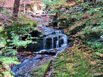
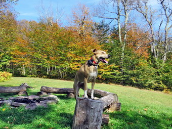
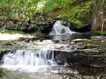
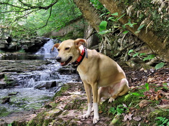
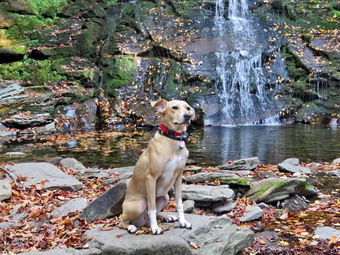 We walked down to the woods road that goes down to the bridge that crosses the brook. The Japanese knotweed was still green and overgrowing the trail. I stopped to take some pictures of the knotweed which I used to keep clear with a machete. I decided to walk to the falls since I could see there were no people there at the time. The informal path to the falls was pretty clear as someone had cut back the vegetation. We walked along the path and then down the bank to the streambed. The falls consisted of a small stream of water flowing down over the rock layers. It was pretty but the volume was nothing compared to the usual flow. I took some shots including some of Sheena who "automatically" posed in front of the falls. I took pictures of the upper part of the falls and some of the pool beneath the falls. I also snapped some shots downstream. I was happy to see that there were no rock piles in the area below the falls. When I was done, we headed back up the bank and out to the main trail. We turned right and then at the trail junction, we turned to the left to climb the steeper hill toward Mud Pond. The trail was dry and covered with a layer of leaves and the outlet stream from Trout Pond was almost dry. I was surprised that no one had claimed the large camping site on the right side of the trail. The sun was out and as soon as we started to climb the hill, I felt warm and opened all the zippers on my hoody. The climb seemed much easier than I remembered but the rock were much worse. The leaves also covered the rocks which made picking a path much harder. There was one large blowdown across the trail which would require a chainsaw to remove it. I thought I might call DEC Region 4 to report it and to ask for Ranger Elliot who does magic with a chainsaw. We reached the top of the hill at 10:48 M after hiking 1.6 miles. The woods road down the other side was also dry when it is usually wet. We walked passed the trail back to Trout Pond and continued on the Mud Pond Trail looking for the woods road that led down to Mud Pond. We passed a sign for a campsite where there was a proper fire ring set up. Just after that was the woods road so we turned left and headed down to the shores of the pond. We came to the shore and I noticed the water level was relatively high compared to other lakes and ponds. I put down my pack and got out the camera. There was very little color on the leaves remaing on the trees and there weren't many of those. The sky was blue but flat with only a few wispy clouds. I took pictures and then returned my camera to the lack and walked back out to the main trail. We turned right and walked a short distance to the trail junction. At 2.1 miles we made a left to follow the trail up to the shoulder of Cherry Ridge. When we started on the trail, I again noticed that there was no water even in places that are often wet and muddy. We walked through the forest of small birch trees and down the other side. There were also a few small blowdowns along the trail that needed to be cleared. Most of these could easily be removed with hand tools. The large trunks that had been on the trail had all been cleared by a DEC crew. The ascent continued for the next 1.2 miles but it was more boring than difficult. At 3.3 miles into the hike we were at the highest point and ready to start the descent to Trout Pond. The trail continued to be very rocky with a few sticks thrown in which made the descent tricky and hurt my feet a little.
 The descent of the trail went more quickly than I had thought. As we were approaching the pond I caught what looked like sunlight electing off glass. I put Sheena on her leash and as we got closer to the trail junction I could see that there was a small SUV parked on the trail and a pickup trick backed up so that its back tires were in the lake! We walked to Te bridge over the outlet and I got out my camera. Taking pictures of the lake was challenging because of the position of the sun. I did my best to get some good shots making sure I took one of the pickup. There were people walking through the water near the trout spawning box and I began to believe they might be from the DEC. I took some shots of the completely dry inlet stream before putting away the camera and shouldering my pack. We continued on the trail toward the SUV which had DEC written on the door. We crossed the small bridge and headed toward the outlet end of the pond. The trail was completely dry in places where is is always wet. I saw three people ahead but did not know whether they were other hikers or DEC employees. I put Sheena on her leash and as we approached the people I recognized a friend from Livingston Manor who introduced the couple as his friends. We talked for a few minutes and the woman said she thought she recognized me. My friend mentioned I was a member of the ambulance corps and the woman remember that I had cared for a family member the year before. She renewed an invitation to hike on their large tract of private land! Sheena and I were a little faster than this group and they let us pass as we headed for the outlet end of the lake.
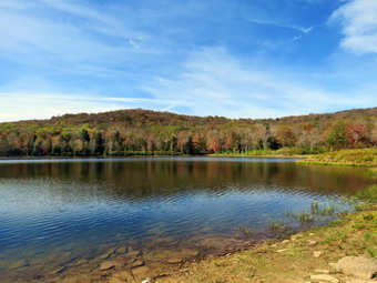
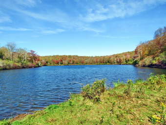
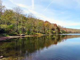 When we came to the path to the lake, we turned right and walked to the beach where I put down my pack. Sheena and I walked over to the shore so that I could take some pictures of the pond. There were some nice reflections on the clouds and trees in the water but there were very few leaves left on the trees and their color was muted. I snapped a few shots of the lake including some of the water level. The volume of water was greatly reduced with the spillway completely dry and at least 10 feet from the water. I took some more shots from different angles before walking back to my pack. I packed up in a hurry because the group of three was approaching and I wanted to stay ahead of them. We headed back to the main trail just ahead of the group. I said "Hello" and then started down the trail at a quick pace. We were soon considerably ahead of the other hikers. The hike from the outlet to the trail junction is all downhill and on this day it was dry. I continued to follow the quick pace set by Sheena. We were soon at the trail register and the trail junction where our loop had started. We continued on the main trail hiking passed the knotweed and crossed the bridge over Russell Brook. The SUV that had been at the other end of the pond came up behind us so I pulled Sheena off the trail to let it pass. We walked up to the lower parking area which still had three cars but they were different than the ones that had been there at the beginning of the hike! The SUV drove through the gate and closed it and drove up the road out of sight. As we walked up the road back to the car, I Merced there was no one at the falls and the van at the campsite was gone. The walk up the road was easier and quicker than I thought it would be. We arrived back at the car at 1:02 PM having covered 6.0 miles and 1150 vertical feet in 3 hours and 8 minutes. Our overall speed was 2.0 mph with a moving average of 2.2 mph The temperature was 60 degrees as I pulled away.
![]()
![]()
![]()
![]()
![]() On Tuesday, September 30th, I wanted to get in a longer hike than I had been doing recently. I had coverage for ambulance calls from 8:00 AM to 2:00 PM so we could hike for up to 4 hours without guilt. When I got up at 9:00 AM it was 60 degrees on the back porch amd I knew the temperature was forecast to rise throughput the day. I wanted to get out and hike to some elevation to test my fitness. I decided to head to the Frick Pond area and hike the Flynn Trail toward Beech Mountain where there are several good viewpoints. I was hoping that there would be some nice colors on the fall leaves. I started to get ready at 9:30 AM with the skies blue but without the puffy white clouds that add to landscape pictures. Sheena was pretty excited as I started to get ready as getting out to hike is her favorite thing. I got dressed in my new Columbia Omni-shade short-sleeved crew top with no baselayer due to the expected heat. I put on a pair of RailRiders hiking pants which are expensive but last a long time and have features like deep pockets and a generous cut which I really like. I decided to put on my Keen Durand hiking boots which fit well. I added a new pair of Xstance insoles in an effort to find the best support and cushioning for my feet. These insoles have shock absorbing gel pads, TPU arch support, and memory foam cushioning all wrapped in a breathable fabric. The insoles have been hyped by their manufacturer and seemed to be living up to their claims. I grabbed a pair of Leki Micro Vario poles I have been using for some time because they are light and lock without slipping. I wore my OR floppy hat as shade from the sun and a place to sprat insect repellent. I put my gear in the back of the car and Sheena in the back seat and left my house at 10:50 AM. I drove out the DeBruce Road about 6 miles to Mongaup Road and turned left. I continued up the road to the point where it splits and stayed left on Beech Mountain Road. It was a short drive to the parking areas on the left. There were mo cars in either parking area. I parked in the smaller lot. I got out and set my GPS. Even though I had hiked this area extensively, I like a record of what I do on each hike. I made sure Sheena's ecollar was turned on and I let her out of the car. She immediately began to run around following her nose. We crossed the road at 10:07 AM to begin our hike on the Flynn Trail with the temperature at 72 degrees.
On Tuesday, September 30th, I wanted to get in a longer hike than I had been doing recently. I had coverage for ambulance calls from 8:00 AM to 2:00 PM so we could hike for up to 4 hours without guilt. When I got up at 9:00 AM it was 60 degrees on the back porch amd I knew the temperature was forecast to rise throughput the day. I wanted to get out and hike to some elevation to test my fitness. I decided to head to the Frick Pond area and hike the Flynn Trail toward Beech Mountain where there are several good viewpoints. I was hoping that there would be some nice colors on the fall leaves. I started to get ready at 9:30 AM with the skies blue but without the puffy white clouds that add to landscape pictures. Sheena was pretty excited as I started to get ready as getting out to hike is her favorite thing. I got dressed in my new Columbia Omni-shade short-sleeved crew top with no baselayer due to the expected heat. I put on a pair of RailRiders hiking pants which are expensive but last a long time and have features like deep pockets and a generous cut which I really like. I decided to put on my Keen Durand hiking boots which fit well. I added a new pair of Xstance insoles in an effort to find the best support and cushioning for my feet. These insoles have shock absorbing gel pads, TPU arch support, and memory foam cushioning all wrapped in a breathable fabric. The insoles have been hyped by their manufacturer and seemed to be living up to their claims. I grabbed a pair of Leki Micro Vario poles I have been using for some time because they are light and lock without slipping. I wore my OR floppy hat as shade from the sun and a place to sprat insect repellent. I put my gear in the back of the car and Sheena in the back seat and left my house at 10:50 AM. I drove out the DeBruce Road about 6 miles to Mongaup Road and turned left. I continued up the road to the point where it splits and stayed left on Beech Mountain Road. It was a short drive to the parking areas on the left. There were mo cars in either parking area. I parked in the smaller lot. I got out and set my GPS. Even though I had hiked this area extensively, I like a record of what I do on each hike. I made sure Sheena's ecollar was turned on and I let her out of the car. She immediately began to run around following her nose. We crossed the road at 10:07 AM to begin our hike on the Flynn Trail with the temperature at 72 degrees.
 The first part of the trail near the road had become further eroded by the recent rains but people had walked around the gully forming a new trail. The walk through the woods was relatively easy and the trail was only damp. When we came to the end of the trail, we turned right onto what once was Beech Mountain Road. This area of the trail was also damp. I wondered if the rest of the trail would be the same. Starting out my whole body was tired particularly my legs. The further we hiked the better I felt. I set a relaxed pace up the Flynn Trail at first but that increased as we continued up the trail. Sheena was about 20 feet ahead of me all the time. Every time I slowed down she did also to keep the same distance. Sometimes she would venture off the trail following a game trail or chasing a squirrel. Whenever she got too far ahead I gave the command "Not too far" and she would come right back to me. We did not stop along the way but continued toward the junction with the Big Rock Trail. The Flynn Trail is uphill all the way for the first 1.7 miles to the Big Rock Junction. We passed the mile mark around the point where there is a clearing to the right of the trail. We were soon walking the final uphill section to the junction with the Big Rock Trail. It was 10:52 AM so we had covered the 1.7 mile distance in 45 minutes which was a vry good time. We continued through the junction and passed through the gate which is the boundary between state land and Beaverkill Land Trust property. It was a short walk to the point where the Flynn Trail heads left and downhill to Hodge Pond. Here we turned to the right on the woods road and walked along the road to the junction of some roads above the pond. At this junction a road turns left to go down to the pond. Just a little further on the road splits with the left fork passing by the site of the former Beech Mountain Boy Scout Camp and ending up on Shin Creek Road in Lew Beach. The camp has been bulldozed by the Land Trust because the building were in ruins and collapsing. The road out to Shin Creek Road is now available for hiking and has a nice parking area near Shin Creek Road. There was a sign facing me that said "Parking" which made me scratch my head. There is a grassy "field" in that direction but it looked unused. We continued up the hill toward the Hodge Pond Lookouts on a woods road that surrounds Flynn's Point on Beech Mountain, the highest point in Sullivan County. As we walked, I could see that there had not been any vehicles on the road recently as there were no new tracks and a thick layer of leaves was present. I had noticed that I was a little tired walking up the Flynn Trail but felt even more energized walking up the road. There had been some work done of the road creating runoffs so that water would run into the woods preventing erosion.
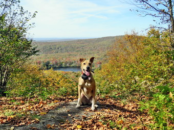
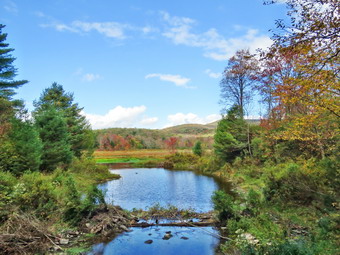
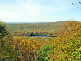 I wasn't really tired so we pushed the pace a little more. The sun was out and there was a slight breeze blowing making the conditions ideal for hiking. When we got to the old sand and gravel pit where the trail levels the sun hit me full force and I realized how hot it really was. The trail began to gain elevation again and we passed by a spring house on the right where Sheila used to like to dig in the water and get a drink. Sheena also got a drink but the amount of water was very small. There are several twists and turns along this road and it is sometimes hard for me to know exactly where I am. At 2.7 miles we came to a lookout on the left of the trail. The lookout had grown in so that there was almost no view except for the tops of some hills. We did not stop but continued on the road as it made a sharp right turn. Just after this the road turned to the left and another trail branched off to the right. We followed the road to the left as it gained some elevation then started downhill. We passed a woods road on the right and then the path on the left toward Mongaup Mountain, one of the Catskill Highest Hundred. The road turned to the right and soon led to a cabin with a beautiful lawn. The lawn had an incredible view to the east with many of the 3500 foot peaks visible. The panorama from this lookout takes in the Burroughs Range and many of the other Catskill peaks. Unfortunately, the trees have begun to grow up and are starting to limit the view. The sky was flat without and distinct clouds and there was a haze hanging over the mountain peaks. Most of the trees were still green or had lost their leaves but there were some ice colors especially in the trees nearby. I got out my camera and took some pictures. I posed Sheena near the fire ring and took some shots of her. She really seems to get posing for photos. When we were done, I got a drink and ate a bar before continuing on the woods road. Sheena was impatient as she always wants to be in motion and she easily found the woods road and head out ahead of me. We climbed a short hill to the woods road that surrounds Beech Mountain and turned left. We followed the woods road clockwise around Beech Mountain. There are some impressive ledges on the right of the trail going in this direction. We came across a blowdown that had been cut by chainsaw. Another part of the tree had fallen across the trail and would have to be cleared. We walked around the blowdown and arrived at the Hodge Pond Lookout. I dropped my pack and took out my camera. I took a picture of the graphic sign at the lookout which indicated the danger of falling off the ledge. A month ago the view was blocked by trees but someone had cut down most of the trees and brush blocking the view. There was an exceptional view from the viewpoint so I walked out to the lookout to take pictures. I took some pictures of the pond below and the hills in the distance. The view was a little hazy in the distance. When I was done taking pictures, I had Sheena sit on the viewpoint while I took some shots with the pond and the leaves in the background. I got another drink and gave some to Sheena.
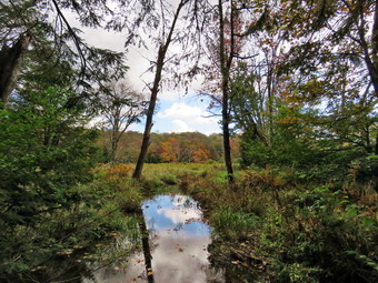
 We continued on the woods road traveling clockwise around Beech Mountain. The trail was only damp in several places and the rest was dry. We were back at the road and turned left to start downhill. We definitely picked up the pace as I knew the rest of the trip back was all flat or downhill. The trip down was much quicker than the trip up. When we reached the bottom of the hill, it was 12:10 PM so I decided to turn right on the woods road to walk down to Hodge Pond. My ambulance coverage ended at 2:00 PM but I felt I had plenty of time to extend the hike. We walked down the woods road to the field at the outlet end of Hodge Pond. We walked over to the shore where I took off my pack and got out the camera. The water level in the pond was slighty lower than I had seen it before but much higher than many other ponds or lakes. The trees around the pond showed some colors so I concentrated on them taking pictures from various angles and zooms. I also took shots of the outlet that had been dammed by the beavers. This area was now part of the pond including a section of the Flynn Trail! The water here was a little lower than on previous trips but the dam looked very solid. I packed up my camera and we headed for the point where the Flynn Trail entered the woods. We started up the hill which always seems long to me but I was feeling pretty energetic on this day. Sheena was ahead of me when I heard barking behind me. I turned around to see a small fluffy dog walking up the trail toward us. Sheena turned to go to greet the dog but I called her off. I took a step toward the dog and it ran back down the trail. This was a strange encounter but it was even stranger that I heard no one call the dog or speak a word. As we continued up the trail I listened carefully and heard nothing. I never saw the dog or the owner again. I began to think the dog may have gotten loose and was lost! The trip up the hill went quickly and we were soon at the junction with the woods road that we had used earlier. We stayed right on the Flynn Trail and soon passed through the gate. We arrived at the junction with the Big Rock Trail at 12:40 PM after hiking 5.1 miles. I still had some time so we turned right and started down the Big Rock Trail.
 The trail was covered in leaves that had fallen from the trees. Some were bright colors while others were brown. There were even some reds from the maple trees along the trail. The hike down the trail went well and more quickly than I expected. It was definitely easier than the uphill hike except for the toe bang! This trail can be tricky as there are three levels that make it seem like the bottom of the hill. We were soon at Times Square and I thought about turning right to hike up and around the Logger's Loop to add some distance to our hike. I eventually turned left to walk the final section of the Loggers Loop as I had not been that way in some time. This section of the trail was a little wetter than the rest fo the trail had been. We descended a little and then started to climb up the trail. The trail was dry enough to walk straight up the hill without sidestepping to avoid any mud. We reached the top of the hill and started downhill toward Gravestone Junction. We came to two blowdowns near the primitive campsites. The blowdowns have been there for months blocking the trail as there has been no maintenance. The NYNJTC was supposed to be assigning new maintainers or sending the Catskill Trail Crew to maintain these trails. Apparently, they have done neither. This is a shame as I always kept these trails in good condition and either cleared them myself or enlisted one of the local rangers. The trails around Frick Pond are used by many people as an introduction to hiking and are recommended by many local businesses and organizations. Sheena walked up to each of the blowdowns and jumped over them. I walked up to the blowdowns and sat on them to get over. We continued our hike by walking through chest high weeds that almost obscured the trail. This was another black mark on the NYNJTC as it made the trail less than inviting. When we reached Gravestone Junction, we turned left on the Quick Lake Trail and headed back toward the parking area. We passed the Lobdell Memorial marker which was in good shape. The trail is very rocky and was a little wet on this day. We passed the trail register and were soon back at the car. It was 1:30 PM and we had hiked 7.1 miles in 3 hours and 23 minutes gaining 1303 feet along the way. We had stopped for a total of 18 minutes. Our speed was 2.0 mph overall and 2.3 mph moving. The temperature had risen to 76 degrees!
![]()
![]()
![]()
![]()
![]() On Monday, September 29th, I was committed to helping a couple from Ohio hike the Finger Lames Trail. I picked them up at the Denning Road Trailhead at 7:15 AM and drove them to the point where the FLT cross Route 206 between Roscoe and Donwsville. I dropped them off at 8:15 AM so they could begin their adventure. I had help them plan an itinerary that had a reasonable amount of miles each day and allowed camping at some leantos. When I got home my crew had already covered two ambulance calls so when another came in I decided to go. When I returned my wife and I planned to eat at Caf� 43 but just as we arrived the pager sounded for another call. I responded to the call with my driver. I got home at 12:30 PM and confirmed with another EMT that they would cover for the next hour and a half! I asked Cindy if she would like to go to the Parksville Rail Trail as it is close but interesting with a nice falls. She said "Yes" and we began to get ready with the temperature at 72 degrees with bright blue skies and lots of sun. The Parksville Rail Trail is under three miles out and back but keeping a quick pace helps increase the difficulty. Sheena actually does get in about twice the mileage that I do as she forges ahead and then comes back to me! I have transitioned from using a leash all the time to using a GarmimSport PRO electronic collar which has many versatile settings and seems to do the job. This allows Sheena to roam and keeps me sane by not having to yank on her leash. It seems that Sheena likes hiking as she smells my clothes and then runs to sit by the door! I got dressed in a new Columbia Omni-Shade Omni-Wick shirt without a baselayer. I put on a pair of RailRiders hiking pants which are expensive but last a long time and have features like deep pockets and a generous cut which I really like. I thought about wearing a pair of low-cut and lighter hiking shoes but thought the trail might be wet and muddy. I decided to put on my Keen Durand hiking boots which fit well. I added a new pair of Xstance insoles in an effort to find the best support and cushioning for my feet. These insoles have shock absorbing gel pads, TPU arch support, and memory foam cushioning all wrapped in a breathable fabric. The insoles have been hyped by their manufacturer and seemed to be living up to their claims. I grabbed a pair of Leki Micro Vario poles I have been using for some time because they are light and lock without slipping. I didn't bother to wear my OR floppy hat or gaiters. I also decided not to take my pack but to hike as fast as Cindy could hike. I put our gear in the back of the car and Sheena in the back seat and we left Livingston Manor at 1:10 PM. I drove out Old Route 17 toward Parksville and turned left under the Quickway overpass onto Service Road. I drove toward Parksville and pulled into the parking area on the right side of the road just after Fox Mountain Rd. There were no cars parked in the lot when we arrived. I made sure Sheena's ecollar was adjusted correctly and then I let her out of the car at 1:25 PM. The temperature was 74 degrees and the sun made it feel warmer.
On Monday, September 29th, I was committed to helping a couple from Ohio hike the Finger Lames Trail. I picked them up at the Denning Road Trailhead at 7:15 AM and drove them to the point where the FLT cross Route 206 between Roscoe and Donwsville. I dropped them off at 8:15 AM so they could begin their adventure. I had help them plan an itinerary that had a reasonable amount of miles each day and allowed camping at some leantos. When I got home my crew had already covered two ambulance calls so when another came in I decided to go. When I returned my wife and I planned to eat at Caf� 43 but just as we arrived the pager sounded for another call. I responded to the call with my driver. I got home at 12:30 PM and confirmed with another EMT that they would cover for the next hour and a half! I asked Cindy if she would like to go to the Parksville Rail Trail as it is close but interesting with a nice falls. She said "Yes" and we began to get ready with the temperature at 72 degrees with bright blue skies and lots of sun. The Parksville Rail Trail is under three miles out and back but keeping a quick pace helps increase the difficulty. Sheena actually does get in about twice the mileage that I do as she forges ahead and then comes back to me! I have transitioned from using a leash all the time to using a GarmimSport PRO electronic collar which has many versatile settings and seems to do the job. This allows Sheena to roam and keeps me sane by not having to yank on her leash. It seems that Sheena likes hiking as she smells my clothes and then runs to sit by the door! I got dressed in a new Columbia Omni-Shade Omni-Wick shirt without a baselayer. I put on a pair of RailRiders hiking pants which are expensive but last a long time and have features like deep pockets and a generous cut which I really like. I thought about wearing a pair of low-cut and lighter hiking shoes but thought the trail might be wet and muddy. I decided to put on my Keen Durand hiking boots which fit well. I added a new pair of Xstance insoles in an effort to find the best support and cushioning for my feet. These insoles have shock absorbing gel pads, TPU arch support, and memory foam cushioning all wrapped in a breathable fabric. The insoles have been hyped by their manufacturer and seemed to be living up to their claims. I grabbed a pair of Leki Micro Vario poles I have been using for some time because they are light and lock without slipping. I didn't bother to wear my OR floppy hat or gaiters. I also decided not to take my pack but to hike as fast as Cindy could hike. I put our gear in the back of the car and Sheena in the back seat and we left Livingston Manor at 1:10 PM. I drove out Old Route 17 toward Parksville and turned left under the Quickway overpass onto Service Road. I drove toward Parksville and pulled into the parking area on the right side of the road just after Fox Mountain Rd. There were no cars parked in the lot when we arrived. I made sure Sheena's ecollar was adjusted correctly and then I let her out of the car at 1:25 PM. The temperature was 74 degrees and the sun made it feel warmer.
 The first part of the trail was wet from the rains that had fallen during recent storms. There was evidence of small streams running down the trail from the brief but heavy rain. Off her leash Sheena would run ahead of me a certain distance and then maintain that distance by waiting for me or increasing her pace. We were soon back under the cover of the trees. Once we were hiking on the trail, we were sheltered from the sun but I was still warm. The trail was wet with soft and muddy patches in all the usual spots. The trail runs parallel to the Little Beaverkill and the new section of State Route 17. It follows the route of the O&W railroad and is very flat. Sheena was setting a quick pace and I didn't mind as long as she would listen and wait for me when necessary. The water level in the stream was still low despite the rain. We continued walking on the trail through some muddy patches until we came to the viewpoint just before the wooden walkways. This spot has a nice view down to the stream and the skies were blue with some nice clouds. We walked across the wooden walkways which were wetter and slipperier than during our last visit. The area before the bridge was only damp. Just after the bridge was a large patch of mud that was a little larger than usual. The culvert under the bridge appeared permanently blocked and the water forms the mud. No one seems concerned about solving this problem. I walked around the mud to continue the hike but Sheena walked right through it. We came to the landslide that had brought down several trees that had been cut and cleared. This area is now muddy but there were some stepping stones. Sheena does not seem to mind sloshing through the water and wading through the mud. As we walked, we could hear the increase in noise from the stream. I looked up to a couple walking toward us and I took Sheena off the trail until until they passed us. We soon reached the falls. As we walked by I inspected them and found the water was about the same as last time.
 We pushed on toward the other end of the trail continuing toward Parksville with Sheena in the lead. I did my best to keep up with her and Cindy wasn't far behind. I did take a peek at the stream from the bench on the trail. Within a few minutes, we were nearing the Parksville end of the trail and Sheena was eager to continue. We came to a spot in the trail where we could see the other side. The large dog that is often there was absent. We continued toward Parksville where the dogs near the end of the trail were barking their heads off but, strangely, there was no loud music playing. The gate at the beginning of the trail was lying on the ground. Whoever laces the poles has not learned than they must be deeper and have more cement to support them. We tagged the end of the trail when we reached the sign at the Parksville end of the rail trail. It was 1:59 PM and it had taken us 31 minutes to hike the length of the trail non-stop. We immediately turned around and started back toward the car. We set a fast pace back from the falls with Sheena in the lead. Just after we pased the falls, we caught up to the couple we met who were walking slowly and enjoying the beautiful day. I put Sheena on her leash to pass them and released her as soon as we were clear. We soon came to the bridge, we walked around the mud while Sheena pushed through. As we approached the end of the trail, I called Sheena and told her "With" which is the equivalent of "Heel". We arrived back at the car at 1:30 PM after hiking over 2.7 miles in 1 hour and 5 minutes. The temperature had risen to 76 degrees. Sheena seemed fresh and I felt she could have hiked out and back on the trail another time as could I. We returned home and we both had something to drink. There had been no other ambulance calls while we were on the trail which made me feel good.
![]()
![]()
![]()
![]()
![]() On Friday, September 26th, I wanted to get out for a longer hike after sticking to Round Top for several walks. I was supposed to have ambulance coverage from 8:00 AM to 2:00 PM but at 8:30 AM when a call came in no EMT responded. I responded to the mutual aid call for another corps. When I got home I asked Cindy if she would like to go to Frick Pond. She said "Yes". I planned a route up the Flynn Trail and down the Big Rock Trail to Frick Pond. We started to get ready at 10:45 AM, the temperature on the back porch was 72 degrees with blue skies and towering white clouds. I got dressed in a new Columbia Omni-Shade Omni-Wick shirt without a baselayer. I put on a pair of RailRiders hiking pants which are expensive but last a long time and have features like deep pockets and a generous cut which I really like. I decided to put on my Keen Durand hiking boots which fit well. I added a new pair of Xstance insoles in an effort to find the best support and cushioning for my feet. These insoles have shock absorbing gel pads, TPU arch support, and memory foam cushioning all wrapped in a breathable fabric. The insoles have been hyped by their manufacturer and seemed to be living up to their claims. I grabbed a pair of Leki Micro Vario poles I have been using for some time because they are light and lock without slipping. I put on my OR floppy hat in case I needed to use insect spray and wore my OR gaiters in case we met up with any ticks. We put our gear in the back and Sheena in the backseat and headed out the DeBruce Road at 11:10 AM. After 6 miles, at Mongaup Pond Road, I turned left and continued to follow the road bearing left onto Beech Mountain Road at the fork. When we arrived in the parking area there was one car parked in the smaller lot and I parked next to it. Sheena was acting as if she hadn't hiked in a month as she ran around and headed for the trail. The temperature was 67 degrees and the skies were blue with white clouds with a slight breeze blowing. I set my GPS as we got ready to head out on the Flynn Trail. We crossed the road and began our hike at 11:30 AM.
On Friday, September 26th, I wanted to get out for a longer hike after sticking to Round Top for several walks. I was supposed to have ambulance coverage from 8:00 AM to 2:00 PM but at 8:30 AM when a call came in no EMT responded. I responded to the mutual aid call for another corps. When I got home I asked Cindy if she would like to go to Frick Pond. She said "Yes". I planned a route up the Flynn Trail and down the Big Rock Trail to Frick Pond. We started to get ready at 10:45 AM, the temperature on the back porch was 72 degrees with blue skies and towering white clouds. I got dressed in a new Columbia Omni-Shade Omni-Wick shirt without a baselayer. I put on a pair of RailRiders hiking pants which are expensive but last a long time and have features like deep pockets and a generous cut which I really like. I decided to put on my Keen Durand hiking boots which fit well. I added a new pair of Xstance insoles in an effort to find the best support and cushioning for my feet. These insoles have shock absorbing gel pads, TPU arch support, and memory foam cushioning all wrapped in a breathable fabric. The insoles have been hyped by their manufacturer and seemed to be living up to their claims. I grabbed a pair of Leki Micro Vario poles I have been using for some time because they are light and lock without slipping. I put on my OR floppy hat in case I needed to use insect spray and wore my OR gaiters in case we met up with any ticks. We put our gear in the back and Sheena in the backseat and headed out the DeBruce Road at 11:10 AM. After 6 miles, at Mongaup Pond Road, I turned left and continued to follow the road bearing left onto Beech Mountain Road at the fork. When we arrived in the parking area there was one car parked in the smaller lot and I parked next to it. Sheena was acting as if she hadn't hiked in a month as she ran around and headed for the trail. The temperature was 67 degrees and the skies were blue with white clouds with a slight breeze blowing. I set my GPS as we got ready to head out on the Flynn Trail. We crossed the road and began our hike at 11:30 AM.
 The Flynn Trail is sited along what used to be Beech Mountain Road which was the access for the Beech Mountain Boy Scout Camp. We walked the trail through the woods which was damp in places but not muddy. We started out slowly but soon were keeping a good pace. We turned right on the woods road and continued to set a good pace up the hill. The path was narrow and it was obvious a stream of water had run down the trail during the rains last night. The trail gains a little over 600 feet in 1.7 miles to the highest point at the junction with the Big Rock Trail. We passed the hemlock that used to form a tunnel but was cleared by the DEC. We began to find some small branches on the trail which had come down in the winds from the storm yesterday. We continued to find similar conditions for the rest of the hike. The day was cool but beautiful with plenty of sun. I began to warm up even though I only had a single layer. On the way up the trail we came to the rock ledges on the right side of the trail. As we approached and the clearing to the right of the trail, I stopped to take some pictures of the rock ledges on the right side of the trail. It was a beautiful day and the sun was shining in the rocks and the trail. Many leaves had come down on the ground but there were still many on the trees although the colors were muted. I noticed that I was very relaxed and decided it was partly due to the sound of the leaves under foot. I thought about visiting the clearing but decided I wanted to stay on the main trail. We descended a little and then began walking uphill. We were soon at the junction with the Big Rock Trail. I thought about extending the hike to Hodge Pond but in the end we turned left to walk down the Big Rock Trail. It was 12:25 PM and we had hiked 1.75 miles uphill in 55 minutes.
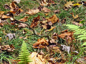
 The Big Rock Trail was only a little damp as we started down the long descent. At one point I looked down and saw a good-sized garter snake sunning itself on the trail. Sheena had already passed by without paying much attention. I carefully put down my pack and got out the camera. I warned Sheena off and took a number of shots. When I was done, I put the camera away and we continued downhill. The snake moved a little as we were leaving. The hike down the trail went well and more quickly than I expected. It was definitely easier than the uphill hike. This trail can be tricky as there are three levels that make it seem like the bottom of the hill. We were soon at Times Square and I thought about turning right to hike up and around the Logger's Loop to add some distance to our hike. I decided against this as it was getting late and we continued our hike by walking straight across Times Square to stay on the Big Rock Trail. The Big Rock Trail around the back of Frick Pond can be very wet but on this day it was damp with a few muddy spots under the leaves. We crossed the two small bridges over the inlets to the pond and I decided to stop to take a few pictures. There was some nice color on some of the trees in the wetlands. The water under the first bridge was backed up from the wetlands. The area under the second bridge was now flowing but with a reduced volume. When we got to the area that was covered by tall evergreens, I pushed on through as I had taken pictures here very recently. The wooden boardwalks continue to show wear with many boards loose and other beginning to rot. Much of the boardwalk now "floats" in midair as the supports are rotting. There was a layer of leaves on the walkways making them slipperier than usual.
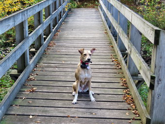 The rest of the trail was damp with several wet and muddy spots. At the next trail junction we turned left on the Quick Lake Trail to head for the bridge across the outlet of Frick Pond. We walked along the west side of Frick Pond to the bridge across the outlet of the pond. The mudhole was wet but not muddy as the drainage work and the stepping stones did their job. I stopped at the bridge for a minute and took a few photographs as there was nice color on the north end of the pond. I took some pictures of Beech Mountain, the highest point in Sullivan County. I took some more shots of the pond and a few of Sheena on the bridge. Sheena and I then walked up the hill to meet Cindy at the top. We continued to Gravestone Junction and passed the Lobdell memorial marker. The marker is a memorial to two children who died in the 1930's in a fire that consumed their cabin. The trail to the memorial was well-worn but the marker was standing intact. The trail back to the register was damp and muddy in spots. We passed the trail register heading toward the parking area. We continued straight ahead to follow the woods road out to the car in the small lot. We arrived at the car at 1:30 PM having hiked 4.0 miles in 1 hours and 55 minutes with an elevation gain of 668 feet. Our overall average speed was 2 MPG with a moving average of 2.3 MPH. The temperature had risen to 71 degrees.
![]()
![]()
![]()
![]() On Monday, September 22nd I planned to get out for a hike but could only do that on Round Top as I was the only EMT around to go on calls. Round Top is always available for a hike and although there are few surprises it is always better than staying at home. I wanted to wait to start the hike until the afternoon after the fall equinox and the official beginning of fall. I did some errands around town and some chores at home. I started to get ready to hike at 2:00 PM with the temperature at 64 degrees on the back porch. Sheena was jumping around and would not leave my side showing she was ready to get outside. She likes to smell my hiking clothes to make sure I am getting dressed in the right clothes. I got dressed in a new Columbia Omni-Shade Omni-Wick shirt without a baselayer. I put on a pair of RailRiders hiking pants which are expensive but last a long time and have features like deep pockets and a generous cut which I really like. I decided to put on my Keen Durand hiking boots which fit well. I added a new pair of Xstance insoles in an effort to find the best support and cushioning for my feet. These insoles have shock absorbing gel pads, TPU arch support, and memory foam cushioning all wrapped in a breathable fabric. The insoles have been hyped by their manufacturer and seemed to be living up to their claims. I grabbed a pair of Leki Micro Vario poles I have been using for some time because they are light and lock without slipping. I didn't bother to wear my OR floppy hat or gaiters. I took my cell phone with me because even though I planned to hike quickly, I was the only EMT around to respond. At 2:20 PM I made sure Sheena's ecollar was turned on and put her on her leash. We walked out the door to start the hike and headed down the driveway and to the street. Sheena knows to pause and look both ways until I say "Cross". We crossed the street and walked through the field next to the Presbyterian Church. We walked to the back of the church and began the ascent of the steepest hill behind the church. The hill is short but gets the circulation pumping and is the steepest and longest climb on the "trail." I held my poles in one hand and Sheena's leash as Sheena pulled my up the hill. We did stop not on the way to the top of the hill. I could really feel that I had been hiking more consistently. At the top we paused for a minute so I could look around at the hills that surround the hamlet of Livingston Manor. The skies were bright blue but there weren't many clouds. The leaves on many trees were turning and falling. We continued the hike by turning left at the trailhead. The trail was completely dry with a covering of leaves. The temperature under the trees seemed cooler than in the sun.
On Monday, September 22nd I planned to get out for a hike but could only do that on Round Top as I was the only EMT around to go on calls. Round Top is always available for a hike and although there are few surprises it is always better than staying at home. I wanted to wait to start the hike until the afternoon after the fall equinox and the official beginning of fall. I did some errands around town and some chores at home. I started to get ready to hike at 2:00 PM with the temperature at 64 degrees on the back porch. Sheena was jumping around and would not leave my side showing she was ready to get outside. She likes to smell my hiking clothes to make sure I am getting dressed in the right clothes. I got dressed in a new Columbia Omni-Shade Omni-Wick shirt without a baselayer. I put on a pair of RailRiders hiking pants which are expensive but last a long time and have features like deep pockets and a generous cut which I really like. I decided to put on my Keen Durand hiking boots which fit well. I added a new pair of Xstance insoles in an effort to find the best support and cushioning for my feet. These insoles have shock absorbing gel pads, TPU arch support, and memory foam cushioning all wrapped in a breathable fabric. The insoles have been hyped by their manufacturer and seemed to be living up to their claims. I grabbed a pair of Leki Micro Vario poles I have been using for some time because they are light and lock without slipping. I didn't bother to wear my OR floppy hat or gaiters. I took my cell phone with me because even though I planned to hike quickly, I was the only EMT around to respond. At 2:20 PM I made sure Sheena's ecollar was turned on and put her on her leash. We walked out the door to start the hike and headed down the driveway and to the street. Sheena knows to pause and look both ways until I say "Cross". We crossed the street and walked through the field next to the Presbyterian Church. We walked to the back of the church and began the ascent of the steepest hill behind the church. The hill is short but gets the circulation pumping and is the steepest and longest climb on the "trail." I held my poles in one hand and Sheena's leash as Sheena pulled my up the hill. We did stop not on the way to the top of the hill. I could really feel that I had been hiking more consistently. At the top we paused for a minute so I could look around at the hills that surround the hamlet of Livingston Manor. The skies were bright blue but there weren't many clouds. The leaves on many trees were turning and falling. We continued the hike by turning left at the trailhead. The trail was completely dry with a covering of leaves. The temperature under the trees seemed cooler than in the sun.
At the first trail junction, I told Sheena "Right" and she immediately turned right and started up the woods road which has the gentler approach of the two. It was a pleasure to walk on the trails and it was obvious more people were using them. Ferns and grasses were beginning to turn brown and there were more leaves on the trail. At the end of the woods road, we turned left up the hill on the trail. We continued up the trail to the first trail junction with the upper blue trail where we turned left to follow the yellow trail along the base of Round Top. We continued on the yellow trail along the base of Round Top. Sheena was running ahead so that I could not see her and then rushing back to find me. We came to the next junction with the blue trail and turned right to head up the blue trail toward the summit. When I we got to the switchback, I decided to follow Sheena as she headed straight up the trail. We continued straight ahead and up the hill toward the summit of Round Top bypassing the white crossover trail. As we passed over the summit, I noticed that the trail showed much less wear and I assumed fewer people were taking the time to walk this trail. We continued over the summit and down the blue trail toward the junction with the yellow trail. We bypassed the white crossover trail again and continued down to the yellow trail. At the junction with the yellow trail we turned right and walked the yellow trail along the base of Round Top toward the next junction with the blue trail. At the next junction, we turned left and started slightly downhill toward the lookout over town. We passed the "sitting rock" and continued downhill. Sheena was ahead of me but she was sometimes hard to spot as he color blends into the leaves on the trail. Everything was starting to turn yellow and brown including the ferns along the way. As we reached the lookout, we followed the yellow trail as it turned left. We walked down the hill to the first trail junction. At the first trail junction, we immediately turned around and started back up the trail.
Climbing the hill to the lookout seemed easier as I have been hiking more. As we reached the top of the hill, we followed the yellow trail as it continued passed the upper part of the lookout. Where the trail turned right, we followed it uphill passing through a large area of ferns which were turning fellow and brown. We passed the sitting rock and continued uphill to the junction with the blue trail. We turned right to follow the yellow trail along the base of Round Top. This area had quite a few branches encroaching on the trail and I knew I should make a trip to trim them before winter. When the snow falls, it collects on the branches and, at times, can almost block the trail. At the junction with the blue trail, we turned left to climb the trail toward the summit. We passed by the white crossover trail and continued toward the summit. We approached the top, walked over the summit and started down the other side again bypassing the white trail. We continued straight down the blue trail and followed to the junction with the yellow trail. We turned left and again walked along the yellow trail to the next junction with the blue trail. I wanted to add a little more distance so we turned left and again headed toward the summit if Round Top. This time we turned left on the white crossover trail about 2/3 of the way to the top. We walked along the white trail but it was obviously the least used trail. When we are back at the blue trail, we turned left and then left again on the switchback that we had avoided the other two times. There were now two small tree down across the trail. I tried dislodging the second but it would not drop. We made the turn in the woods and headed back to the main trial. We turned left on the main blue trail and left on the yellow trail when we reached the bottom of the hill. We walked along the base of Round Top adjourned right when we again reached the junction with the blue trail. We followed the yellow trail to the woods road and walked the woods road out to the first trail junction. I noticed that Sheena completely blended with the fallen leaves and it was hard to see her until she moved. The cliffs to the right on the trail are always impressive for such a short hike. We turned left and walked straight ahead out to the trailhead where we turned right. We walked downhill to the road behind the church. We walked out through the parking lot and across the street to our driveway. We were back home at 3:35 PM after hiking over 2 miles in 1 hour and 15 minutes. I was glad there were no ambulance calls while we were hiking.