
East Hudson Trails
Besides the thirty-five 3500 foot peaks in the Catskills, there are many other smaller mountains to climb. In addition, there are hundreds of miles of trails to hike. There are also MANY other places to hike also. I have divided the Trails section into list of All Trail, the Catskills, the Shawangunks, Bear Mt/Harriman, East Hudson, West Hudson, New Jersey and Other Trails. The All Trails list includes over 400 different trails and may load slowly on your computer. The "divided" list should load more quickly.
You can view all the East Hudson Trails here.
Clicking on ![]() will bring up an index of trails. Clicking on
will bring up an index of trails. Clicking on ![]() will return you to the top of the page.
will return you to the top of the page.
Anthony's Nose: AT from Route 9D
| Quick Look | ||||
|---|---|---|---|---|
| Difficulty | Round trip | Total climb | Internet Maps | |
| 1.8 miles | 790 feet | AllTrails | ||
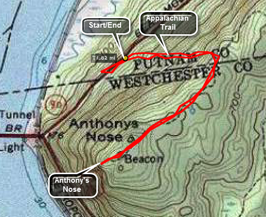 Travel north on Route 9D from the eastern end of the Bear Mountain Bridge. There are several places to park cars along the shoulder or in pulloffs. Be careful walking along Route 9D as the cars travel too fast and the road is too narrow. The trailhead is marked by a sign on the right side of 9D headed north just after the bridge. There is no trail register here but the markings are the white blazes of the AT. The trail initially winds its way toward the rocky crag which is Anthony's Nose. Shortly it turns upward with several steep portions. A few level parts and
switchbacks help you catch your breath. At the top, after only .5 miles, the AT heads northeast to the left. Turn RIGHT onto this wide woods road to head toward Anthony's Nose. As you approach the edge of the cliffs, turn up to your right to get to the lookout. Return to your car by reversing the route.
Travel north on Route 9D from the eastern end of the Bear Mountain Bridge. There are several places to park cars along the shoulder or in pulloffs. Be careful walking along Route 9D as the cars travel too fast and the road is too narrow. The trailhead is marked by a sign on the right side of 9D headed north just after the bridge. There is no trail register here but the markings are the white blazes of the AT. The trail initially winds its way toward the rocky crag which is Anthony's Nose. Shortly it turns upward with several steep portions. A few level parts and
switchbacks help you catch your breath. At the top, after only .5 miles, the AT heads northeast to the left. Turn RIGHT onto this wide woods road to head toward Anthony's Nose. As you approach the edge of the cliffs, turn up to your right to get to the lookout. Return to your car by reversing the route.
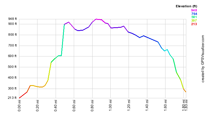
(The image at the left shows the profile of the hike. Remember that all vertical profiles are relative!)
Anthony's Nose: Camp Smith Trail from Route 202
| Quick Look | ||||
|---|---|---|---|---|
| Difficulty | Round trip | Total climb | Internet Maps | |
| 2.1 miles | 850 feet | AllTrails | ||
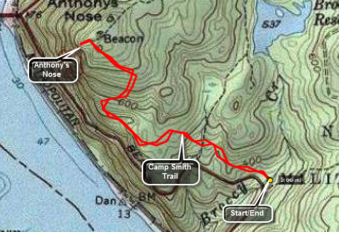 Travel south on Route 9D from the eastern end of the Bear Mountain Bridge for about 1.1 miles and turn left on Route 202 (Jack Woods Road). Watch for the small parking area on the left. Park and start hiking north on the Camp Smith Trail. The trail immediately starts to gain some elevation, drops a little and then ascends to Anthony's Nose. At the top of the climb bear slightly to the left to get to the lookout. Return to your car by reversing the route.
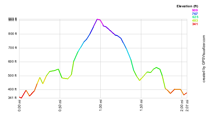
(The image at the left shows the profile of the hike. Remember that all vertical profiles are relative!)
Anthony's Nose: From South Mountain Pass
| Quick Look | ||||
|---|---|---|---|---|
| Difficulty | Round trip | Total climb | Internet Maps | |
| 3.2 miles | 950 feet | AllTrails | ||
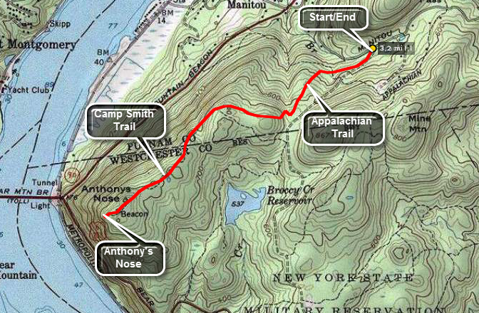 Travel north on Route 9D from the eastern end of the Bear Mountain Bridge for about 1.4 miles and turn on Manitou Road on the right. At the T turn right on South Mountain Pass Road. Drive .5 miles and watch for the small trail head parking on the right. Get on the wide woods road which is the Appalachian Trail.Follow the trail to the right as it starts level and then gains some elevation. At around 1 mile the AT heads right and down to the river. Continue straight ahead to Anthony's Nose. As you approach the edge of the cliffs, turn up to your right to get to the lookout. Return to your car by reversing the route.
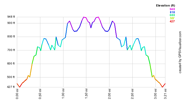
(The image at the left shows the profile of the hike. Remember that all vertical profiles are relative!)
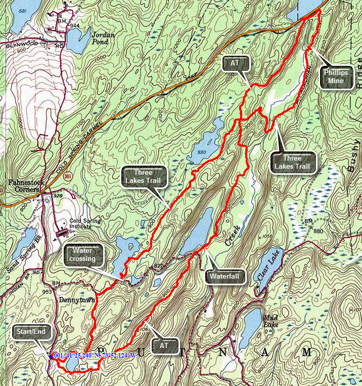
Anthony's Nose: Phelps Mine and Camp Smith Trail
| Quick Look | ||||
|---|---|---|---|---|
| Difficulty | Round trip | Total climb | Internet Maps | |
| 6.7 miles | 2550 feet | AllTrails | ||
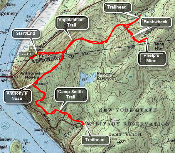 Travel north on Route 9D from the eastern end of the Bear Mountain Bridge. There are several places to park cars along the shoulder or in pulloffs. Be careful walking along Route 9D as the cars travel too fast and the road is too narrow. The trailhead is marked by a sign on the right side of 9D headed north just after the bridge. There is no trail register here but the markings are the white blazes of the AT. The trail initially winds its way toward the rocky crag which is Anthony's Nose. Shortly it turns upward with several steep portions. A few level parts and
switchbacks help you catch your breath. At the top, after only .5 miles, the AT heads northeast to the left. Turn onto this wide woods road to head toward South Mountain Pass trailhead. The road is wide but rocky. Follow the blazes as they turn left into the woods. Obey the posted signs which mark Camp Smith, an active Army National Guard training site! The trail rolls up and down and switches back and forth several times. After about 1 mile it meets another woods road. Turn left and walk out to the trailhead if you wish. On to the way back you will have to bushwhack up the mountain to find the mine. Look for an informal campsite and head up and east. The Phelps mine is clearly marked on the NYNJTC maps. At some point you may hit another woods road that leads directly to the mine.
Travel north on Route 9D from the eastern end of the Bear Mountain Bridge. There are several places to park cars along the shoulder or in pulloffs. Be careful walking along Route 9D as the cars travel too fast and the road is too narrow. The trailhead is marked by a sign on the right side of 9D headed north just after the bridge. There is no trail register here but the markings are the white blazes of the AT. The trail initially winds its way toward the rocky crag which is Anthony's Nose. Shortly it turns upward with several steep portions. A few level parts and
switchbacks help you catch your breath. At the top, after only .5 miles, the AT heads northeast to the left. Turn onto this wide woods road to head toward South Mountain Pass trailhead. The road is wide but rocky. Follow the blazes as they turn left into the woods. Obey the posted signs which mark Camp Smith, an active Army National Guard training site! The trail rolls up and down and switches back and forth several times. After about 1 mile it meets another woods road. Turn left and walk out to the trailhead if you wish. On to the way back you will have to bushwhack up the mountain to find the mine. Look for an informal campsite and head up and east. The Phelps mine is clearly marked on the NYNJTC maps. At some point you may hit another woods road that leads directly to the mine.
As you approach the mine you will notice a slope of "rusty" tailings. Look up the right and walk in that direction and you will see an old, rusty fence surrounding the adit to the mine. At least one section of the fence is down allowing access to the mine adit. Be VERY careful around the mine entrance. The stones are loose and the mine is DEEP! Outside the fence and a little to the right is an airshaft with a grate. Looking through the tailings and mine waste may reveal some mineral samples. The mine was originally opened as an iron mine but copper, zinc and sulfur were all extracted. When you have had enough, retrace your route back to the woods road and follow the AT back to where you ascended from 9D. Continue straight ahead for .5 miles to Anthony's Nose. Depending on the season and the weather the views here can be quite different. They are always interesting but may be clearer or more beautiful on a particular day. The Bear Mountain Bridge is directly below and the Popolopen Gorge Bridge and footbridge below are visible. Bear Mountain with the Perkins Tower are directly across the Hudson. Looking south reveals Iona Island and Indian Point. Depending on the day you may see trains on the tracks on the west side of the river, pleasure boats and barges on the river and birds riding the air currents.
Return to the blue trail from Anthony's Nose and walk straight ahead to another viewpoint. This one has a USGS seal at the top. Continue on down the blue Camp Smith Trail. The trail descends for 1 mile until it reaches a trailhead on Route 202 north of the bridge. (Continuing along this trail for just under 2 miles will bring you to the start of the trail at the Hudson Highlands Gateway.) Along the way there are a few other viewpoints but none as nice as Anthony's Nose. At the trailhead turn around and retrace your path to Anthony's Nose and then to the trail that leads down and back to the car.
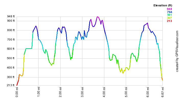
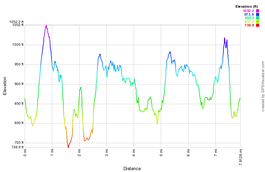
(The image at the left shows the profile of the hike. Remember that all vertical profiles are relative!)
Beebe Hill Fire Tower
| Quick Look | ||||
|---|---|---|---|---|
| Difficulty | Round trip | Total climb | Internet Maps | |
| 1.7 mi. | 400 ft. | AllTrails | ||
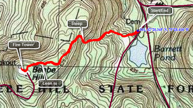 Beebe Hill State Forest is on Route 22 in Austerlitz. Turn north on Osmer Road and drive about 1.6 miles to BarrettPond on the left. The access road to the trailhead is just north of the pond. After parking you may walk through the gate and use the road to the fire tower. You may also use the trail to the left of the information kiosk. The trail is marked with a sign that says "Fire Tower 1 mile" although the distance is shorter. The trail crosses two bridges over small streams on its way to the tower. The first half mile has a few steep sections but it switches back and forth several times. After .5 miles or so you will be on the flat top of the hill and a lean-to will appear on the left. Continue to the end of the trail. There you will find an observer's cabin, another building and the tower. The tower can be climbed and the cab is open all year round. Despite the fact that the hill rises only about 300 feet there are great views in all directions. The best views are to the west where the Catskills can easily be seen.
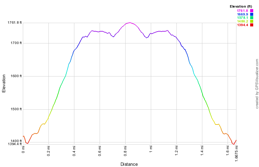
(The image at the left shows the profile of the hike. Remember that all vertical profiles are relative!)
Canopus Lake to Shenandoah Mountain
| Quick Look | ||||
|---|---|---|---|---|
| Difficulty | Round trip | Total climb | Internet Maps | |
| 8.0 mi. | 1570 ft. | AllTrails | ||
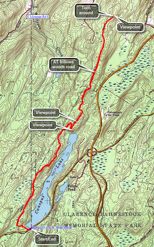 Take exit 13 south off I84 and follow Route 9 south for 6.5 miles to Route 301. Turn left on Route 301, drive 4.6 miles and park on the shoulder of Route 301 just before Canopus Lake. Walk across the road and enter the woods on the AT to start the hike. The trail is very rocky at the beginning and ascends and then descends quite a bit. In the first .5 miles gain over 200 feet and then lose most of it again before gaining it back. You may be able to glimpse views of Canopus Lake through the trees. At about 2.0 miles the trail turns right sharply and begins to climb on a switchback. At the top is a rock outcropping with a nice view of the lake and the beach below. Just a little farther along the trail there is a lookout on the left that has a view to the north and west. At about 2.85 miles you will have dropped some elevation and will hear the traffic on the Taconic State Parkway. At this point the trail starts to follow a woods road and the surface became smoother and easier to walk. Continue to follow the trail NNE until it finally breaks out onto an open rock face at almost exactly 4 miles. The trail begins to descend toward Long Hill Road at this point. There is a USGS marker at the top and a US flag painted on the rocks. Turn around if you have not spotted a car further along the trail. This would be a good idea since it allows hiking 8 miles of trail instead of 4 miles out and 4 miles back.
(The map shows the parking area and the hiking route.)
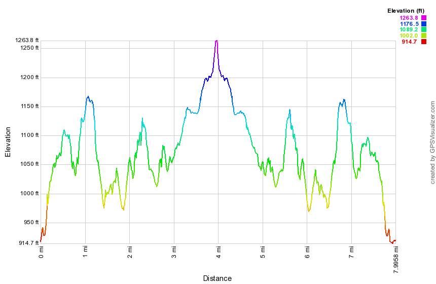
(The image at the left shows the profile of the hike. Remember that all vertical profiles are relative!)
Dennytown Rd to Canopus Lake
| Quick Look | ||||
|---|---|---|---|---|
| Difficulty | Round trip | Total climb | Internet Maps | |
| 7.9 mi. | 1440 ft. | AllTrails | ||
 Take exit 13 south off I84 and follow Route 9 south for 6.5 miles to Route 301. Turn left on Route 301, drive 2.6 miles and turned right on Dennytown Rd. Drive 1.2 miles south and park in the parking area on the left where the AT crosses the road. The parking area is large with a trailhead sign and several stone buildings. Enter the woods at the back of the parking on the AT to start the hike. Ascend a low ridge and walk along the top. The trail will descend and ascend several of these ridges along the way. At 1.4 miles cross Sunk Mine Road and pick up the trail just on the other side. At 1.6 mile you will to cross a small stream that drains a beaver pond. Walk downstream a little to find a small waterfall. Just downstream from the waterfall is a round stone with a hole in the middle. This is an old millstone of some kind. Walk back to the trail and cross the stream. Inspect the beaver pond for recent activity and notice a large marsh covered in reeds downstream. There were many of these along the way. At 2.7 miles you will come to a junction with the Three Lakes Trail. Continue on the AT and you will find that you are walking on a sort of raised causeway supported by stonework. This continues for almost a mile. At 3.6 miles you will arrive at Route 301 and Canopus Lake. There are quite a few pullouts along the roadway. If you like, cross the road to get a better view of Canopus Lake. Turn around and walk northeast on the old road for less than a quarter mile where you will find the Three Lakes Trail on the right. Turned right and start south on the trail. Within a few hundred feet look for a long teach on the right side of the trail which is the Phillips Mine. Many of these mines are simple pits or trenches and they can be hard to spot unless you know what you are looking for. Explore some and then get back on the main trail. At 4.6 miles turn west just after passing a large marsh. This trail is lower than the AT and passes through more bottomland rather than staying on a ridge. At 4.9 miles descend to a small stream and cross the stream on some stones. The trail starts to ascend a ridge on a switchback. At 5.3 miles you will be at the cairn that marks the trail junction. Continue straight ahead on the Three Lakes Trail. At 5.5 miles you will pass by another lake. The trail continues without much elevation change and with a much flatter surface than the AT. At 6.7 miles the trail comes to the shores of the third lake. Just below the lake the trail crosses the outlet stream which can be difficult when the water is high. At 7 miles you will be back at Sunk Mine Road. Turn right and walk uphill for about a tenth of mile before turning south into the woods for the last stretch of trail back to the car. The final part of the trail is slightly uphill and along a small stream and another large marsh. Eventually you will cross the stream and pass by an old stone structure. From here it is a short walk through a meadow and back to the parking area.
(The map above shows the parking area and the hiking route.)
(The image at the left shows the profile of the hike. Remember that all vertical profiles are relative!)
Dennytown Rd to Old Albany Post Rd
| Quick Look | ||||
|---|---|---|---|---|
| Difficulty | Round trip | Total climb | Internet Maps | |
| 10.5 mi. | 2550 ft. | AllTrails | ||
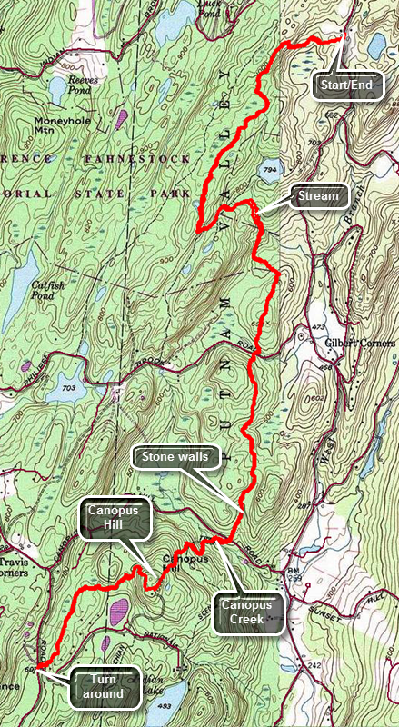 Take exit 13 south off I84 and follow Route 9 south for 6.5 miles to Route 301. Turn left on Route 301, drive 2.6 miles and turned right on Dennytown Rd. Drive 1.2 miles south and park in the parking area on the left where the AT crosses the road. The parking area is large with a trailhead sign and several stone buildings. Cross the road and begin your walk by descending slightly and then climbing to a ridge. This rolling terrain is typical in the area. The trail can have some very wet places with some areas resembling a stream bed while others may have pools of water. At 1.5 miles the trail turns sharply to the north which may seem incorrect but it soon approaches a small stream and begins to follow the stream south again. Eventually the trail heads due south and continues to descend albeit with a few moderate ascents along the way. At 2.7 miles cross South Highland Road and continue to head south and to descend. Crossed Canopus Hill Road at 3.7 miles and descend to Canopus Creek. In high water the creek can be a little challenging to cross but hop from rocks to rock to log and you will get across. In front of you is Canopus Hill and while the hike to the top was only about .7 miles the elevation gain is over 400 feet with a 15% grade. Hike up the hill but watch the blazes as some are clearly wrong! One directs you to the left as the trail turns right! At the top of the hill, there is an open spot but no real viewpoint. The star on the NYNJTC maps shows a lookout a little further along on the descent but there is no lookout. Like so many marked on the Campos this one has been obscured by trees over the years. The descent on the other side is steep and rocky but the elevation loss is not as great as the gain on the other side. At 4.7 miles you will have completed the descent and be very near the Old Albany Post Road. Unfortunately, the trail parallels the road for another .6 miles before crossing one more swampy area. Cross Chapman Road and the Old Albany Post Road and arrive at the end of this section of AT hike. Turn around and follow the same path directly back to the car. Of course, you will have to hike back up and over Canopus Hill and after that the route is mostly uphill. Watch for the network of wide stone walls in the area. Back at the car take some time to look at the stone shed on the left side of the parking area. Walk down to the left of the field along the Three Lakes Trail and inspect the shell of another stone building.
(The map shows the parking area and the hiking route.)
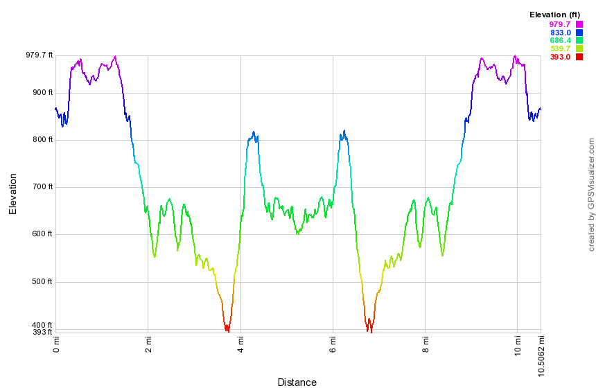
(The image above shows the profile of the hike. Remember that all vertical profiles are relative!)
Depot Hill to Nuclear lake
| Quick Look | ||||
|---|---|---|---|---|
| Difficulty | Round trip | Total climb | Internet Maps | |
| 9.2 mi. | 1690 ft. | AllTrails | ||
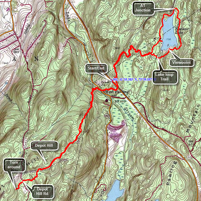
This hike is really from Route 55 to Depot Hill back to Route 55 then around Nuclear Lake and back to the car.Take the Taconic State Parkway north off I84 and then take the next exit for Route 52 toward Carmel. At the Stormville Post Office turn left on Route 216 and follow it to Route 55. Turn right on Route 55 and within 1.5 miles find the AT parking area on the left. Head south on Route 55, cross the road when you meet the AT and head west into the woods. The first part of the trail is a well-packed dirt track which is a little too close to "civilization" judging by the broken bottles. In less than half a mile cross Old Route 55 and head down a set of wooden steps. After a very short walk in the woods, cross the railroad tracks. There may be a rather large beaver ponds on the other side which can be muddy. From the tracks begin an ascent of about a mile toward the top of Depot Hill. The elevation gain is only about 540 feet but there were some steep areas. At about 1.9 miles pass by the summit of Depot Hill without actually hiking over it. Pass by some wetlands as the trail undulates some. This area of the trail just before Depot Hill Road is also very rocky. At 2.3 miles crossed Depot Hill Road which was barely a single lane gravel track at this point. If you hiked to this road before you may turn around. Continue to walk for about another .2 miles and you will overlap the hike from Route 55 to Depot Hill. Turn around and start back to Route 55.
When you are back at Route 55 you will have hiked about 5 miles. You can walk back to the car or continue across Route 55 to hike a loop around Nuclear Lake. The distance from Route 55 to Nuclear Lake appears to be about .6 miles but the trail keeps winding this way and that extending the distance to 1.2 miles. You will eventually come to the first junction with the loop trail even though the lake is not in view. The AT so far has been level in most places and rocky in a few others but there has been very little up or down. Stay on the AT along the west side of the lake. At 6.5 miles into the hike, about 1.5 miles from Route 55, you will get a look at the lake and be able to walk down to the shore. In the early 1970's there was an explosion at a small research facility on the shores of the lake. This scattered a small amount of radioactive material in the surrounding forest. The material was cleaned up and subsequent testing showed no more radiation than normal background. Shortly after the facility was closed and the building razed. Head back to the AT again and the trail becomes very rocky and descends to very near the shore of the lake. Continue around the lake and at 6.8 miles the AT turns left. Bear to the right on the loop trail around the lake. The trail stays pretty far away from the water and from the cliffs that line the eastern shore. This trail starts out fairly flat but soon becomes rocky with a few short but steep ascents and descents. At one point a path to the right leads to a very nice lookout with views of the small island and the rest of the lake. Continue on the main trail and you will soon cross the access road to the lake. Re-enter the trees and complete the loop by rejoining the AT at 7.9 miles into the hike. It is almost exactly 2 miles around the lake and you only have the 1.2 mile walk back to the car to go. As you near Route 55 you may take the blue shortcut trail on the right back to the parking area to avoid hiking along the main road.
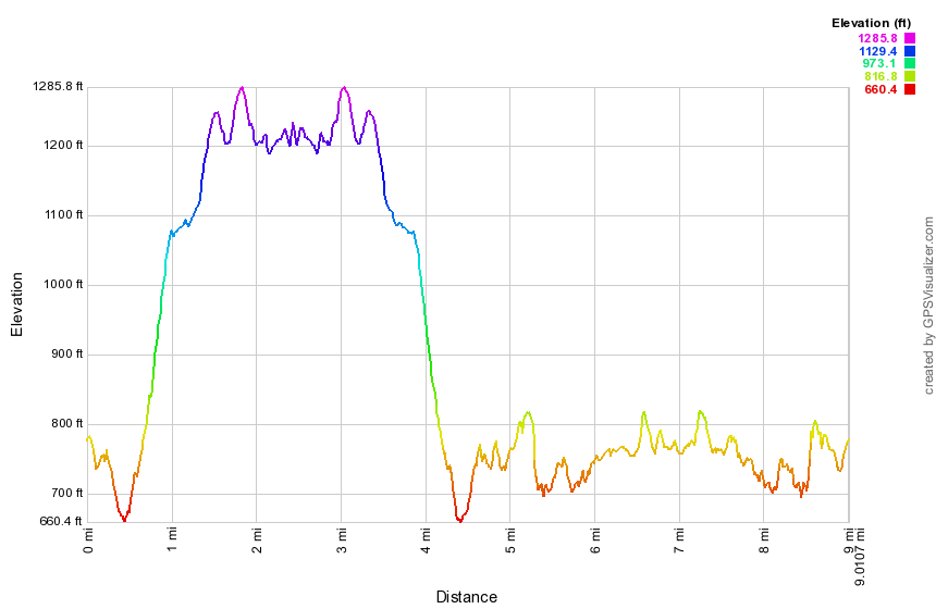
(The image at the left shows the profile of the hike. Remember that all vertical profiles are relative!)
Dickinson Hill Fire Tower
| Quick Look | ||||
|---|---|---|---|---|
| Difficulty | Round trip | Total climb | Internet Maps | |
| 3.0 mi. | 550 ft. | AllTrails | ||
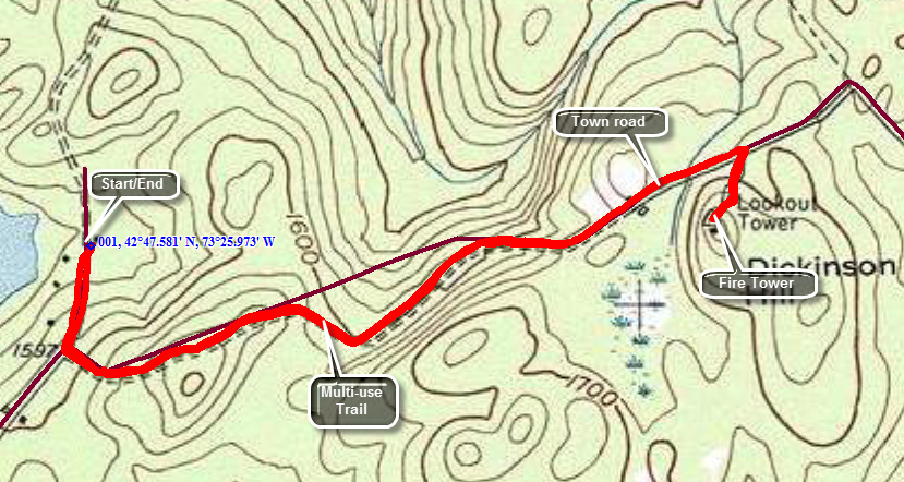 Grafton Lakes State Park is on Route 2 between Troy and Petersburg. Turn north into the park entrance and look for North Long Pond Road. This road is the one you turn onto when you enter the "Winter Entrance" to the park. Drive a little over 2 miles to the parking area at the northeast corner of Long Pond. Just before the parking area you will pass the sign for the fire tower trail on your right. Walk back up the road from the parking area and turn left onto the trail. The trail is a wide woods road and multiuse trail that has no really steep sections. After about 1.25 miles the trail ends at Fire Tower Road near a private residence. Fire Tower Road goes directly to the tower but there is no parking on the road. Walk northeast on Fire Tower Road for a few hundred feet until you are at the gated access road to the tower on the right. Walk up the access road to the tower. The tower can be climbed year round and the cab is always open. There are 360 degree views with the best views of the Catskills to the west and southwest. The only drawback is the communications tower that shares the summit of the hill.
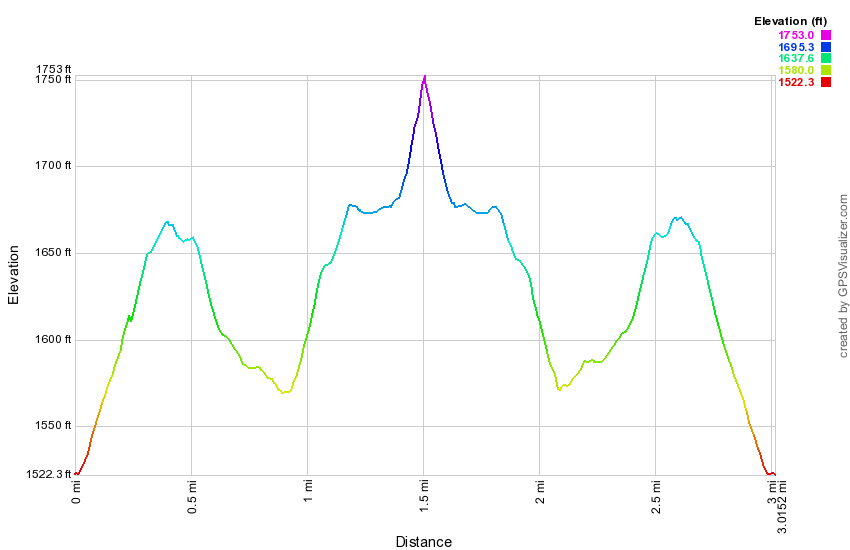
(The image at the left shows the profile of the hike. Remember that all vertical profiles are relative!)
Dover Oak to Hoyt Road
| Quick Look | ||||
|---|---|---|---|---|
| Difficulty | Round trip | Total climb | Internet Maps | |
| 5.9 mi. | 1420 ft. | AllTrails | ||
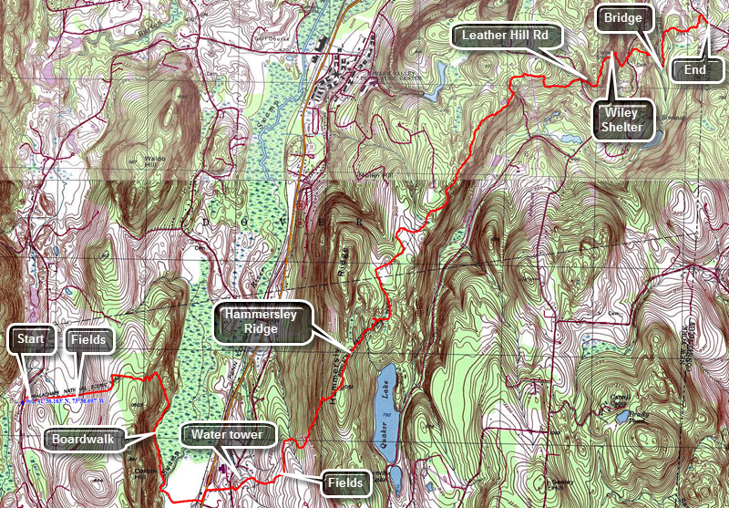
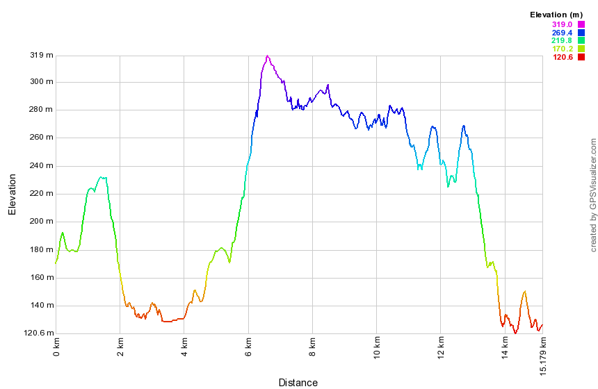
This is one-way and uses a car spot at Hoyt Road. From Wingdale, NY head east on State Route 55 toward Connecticut. Just .2 miles before the Connecticut border, turn right on Hoyt Road. The parking area for the AT is only about .25 miles up Hoyt Road on the right. Park one car in the small lot and then drive west on Route 55 back to Wingdale. Continue west on Pleasant Ridge Road watching for Route 20 (Hoag's Corners Road) on the left. Turn left to drive south and watch for the Dover Oak on the left side of the road. The tree is hard to miss and there may be quite a few cars parked here. Be sure to head east from the tree and hike up through a field on a well-worn track. You will be in the fields or on the edge for a good part of the first mile. At about .6 miles look west and you will see a bare rock face. This is the Cat Rocks which is a popular lookout on the AT. After the first mile you will begin to descend and come to the wetlands around the Swamp River at about 1.4 miles. There is a boardwalk that crosses a small stream and then continues across the marsh. At about 2.1 miles cross the Swamp River on a bridge. At 2.35 miles you will cross the Conrail tracks and find a special station just for AT hikers. Just beyond at 2.4 miles is State Route 22 where you should turn left and hike up the road a few hundred feet to pick up the AT as it again passes through some fields. At 2.7 miles cross Hurds Corners Road and watch out for the electrified fence on the other side. Climb over the fence using the stile and take a look at an interesting wooden water tower in the field. Continue your walk up the ridge by way of the well-packed track through the fields. Enter the woods again at about 3 miles and then begin a sustained ascent at about 3.4 miles. This lasts until you gain the highest point on the hike at 4 miles. This is on Hammersley Ridge just above Quaker Lake which is to the east. Unfortunately, there are no views to be had as you walk along the ridge. From the high point on the ridge the trail is generally downhill for the next 3 miles heading northeast. Most of the walk is on packed dirt trail but there were a few rocky spots. At about 7 miles into the hike the trail turned almost due east and starts to ascend over two bumps that are part of Leather Hill. At 7.7 miles cross Leather Hill Road and continue east toward Duell Hollow Road. There is a steep descent at 8 miles which continues until you cross Duell Hollow Road. On this descent you will pass the Wiley Shelter where the trail makes a sharp right. Shortly after the shelter you will find the water supply for the shelter which is a well with a hand pump. You are getting close to your destination but the trail had one more "curve". The trail ascends from the road and then begins to head south instead of east. This maneuver is to avoid descending into the gully cut by Duell Hollow Brook. In doing so the trail turns a .2 mile hiked into something over a .5 mile detour! You will cross the brook on an interesting foot bridge with a fairly long span and a central support. There is one more short ascent on the other side and then another walk through some open fields. Just after this you will begin to descend through some trees and then break out onto Hoyt Road just north of the parking area.
(The image at the left shows the profile of the hike. Remember that all vertical profiles are relative!)
Dover Stone Church: All Trails
| Quick Look | ||||
|---|---|---|---|---|
| Difficulty | Round trip | Total climb | Internet Maps | |
| 3.7 mi. | 830 ft. | AllTrails | ||
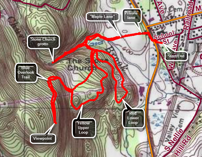
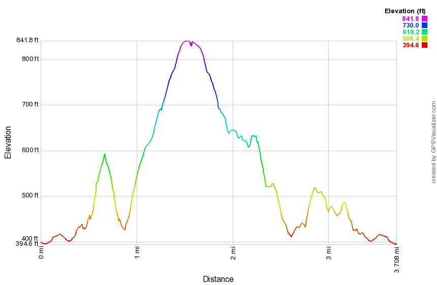
Drive to Dover Plains, NY and park at the Dover Plains Elementary School at 9 School St. There is no parking at the entrance to the Dover Stone Church area which is one a lane that is on private property. Walk out to Route 22, turn right and walk north about 250 feet to a yellow on blue historical sign. Turn left here and walk up a private, gravel driveway. At the top is the sign for the beginning of the Dover Stone Church area. The shape of the sign reflects the shape of the opening of the Dover Stone Church grotto! Walk down the stone steps to a beautiful lane or walkway lined with maple trees. Continue to the other end of the lane to climb the other steps. A short path leads to a sign and kiosk that explain the historical significance of the area and shows a map of the trails. Begin to follow the trail along Stone Church Brook to the bridge over the brook. Just after the bridge, there is a sign directing us to the red, blue or yellow trails. Continue straight ahead along the creek being careful as you negotiate the slippery rocks beside the creek. The rocks are almost always wet from rain, humidity or water from the brook. In a very short distance you will see the opening to the grotto. Continue to walk along the side of the creek on the stones and enter the grotto if you wish being careful as the water may be high enough to make staying dry a problem. There is a 30 foot waterfall at the far end of the grotto but its beauty very much depends on the flume of water in the creek. A low volume makes it easy to get into the grotto but also makes the waterfall pretty tame. There is also a large rock that is locally known as "The Pulpit". Exit the grotto and walk back along the slippery rocks to the trail signs. Turn right to begin walking the new trails which all start out together on a climb. The blue trail is the Overlook Point Trail and is marked as 1.75 miles out and back. The elevation at the parking lot was about 400 feet so any elevation produces a viewpoint. Follow the blue markers as first the red and then yellow trails break off. The trail follows a woods road until the very last portion which is cut through the woods and along the edge of an escarpment. The trail heads south before looping southwest and then north with a final turn to the south. After .7 miles on this trail gains about 420 feet and ends at the lookout. The trail seems to end at a point where the view is limited. Some unmarked paths lead to a rock ledge that is lower but offers a less obstructed view. Head back following the Blue trail to the upper junction with the yellow Upper Loop Trail. Turn right at 1.95 miles to hike this trail. The trail rolls a little as it drops and then climbs to the top of a little hill. At 2.2 miles there is a limited viewpoint and then the trail begins to drop back down to meet the blue trail. The walk is pleasant without too much to see. At 2.5 miles you will be back at the point where all the trails come together. Continue straight ahead to walk the red trail which is marked as the Lower Loop Trail. The first part of this trail passes through some open areas which may have a lot of weeds. It is obvious that the main attraction is the Stone Church with the Overlook Trail a distant second. The Upper and Lower loop trails seem hardly used. Follow the red trail as it heads south ascending a few small hills. At 2.9 miles the trail makes an almost 180 degree turn and heads back to the north. Soon you will be back at the trail junction heading back down to the brook. Follow the trail back out to the kiosk and then to the lane lined with maples. Head back to you car the way you came.
(The image at the left shows the profile of the hike. Remember that all vertical profiles are relative!)
Fahnestock Mines
| Quick Look | ||||
|---|---|---|---|---|
| Difficulty | Round trip | Total climb | Internet Maps | |
| 4.0 mi. | 766 ft. | AllTrails | ||
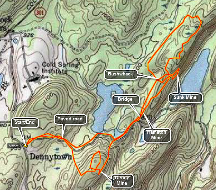 Fahnestock Park on the east side of the Hudson River in Putnam County is beautiful in its own right. It is also the site of several historic iron mines.
From Route 9D on the east side of the Hudson turn east on Route 301 and drive 5 miles to the intersection of Dennytown Road. Turn south and rive for less than a mile to the parking area on the left near the now closed Sunken Mine Road. Walk for about .3 miles on the road and then turn right into the woods to start the bushwhack to the Denny Mine. Head southeast for about .2 miles over a small hill. The Denny Mine is a large pit in the eastern side of the hill. From here head northeast and in another ,2 miles you should pick up the road/trail again. You will pass by a pond on the left. Continue on the road for only about .1 miles to where the road crosses a stream. Turn left on an unmaintained trail. Just after you start up the trail, the long open pits of the Hamilton Mine will be on your right. You can walk up to these pits to "explore" and photograph them. BE CAREFUL as many are filled with water and a fall into one would be a problem. Continue on the path for about .3 miles and then start heading to the left and over the top of the small ridge. The Sunk Mine is on the southeastern side of the ridge and is hidden. There is a steep and "slippery" descent to get down to the mine which consists of several open trenches and one large opening cut into the hillside. Inspect these features with caution as they can be precarious places. You can follow the unmaintained path back to the road and then walk the road back to the parking area. You can also follow the path to its end, only a short distance, where it intersects the blue 3 Lakes Trail. Turn left and follow this trail back to the road and then to the parking area.
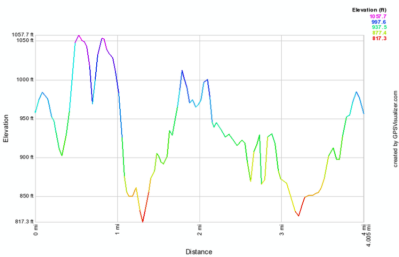
(The image at the left shows the profile of the hike. Remember that all vertical profiles are relative!)
Ferncliff Forest
| Quick Look | ||||
|---|---|---|---|---|
| Difficulty | Round trip | Total climb | Internet Maps | |
| 2.0 mi. | 285 ft. | AllTrails | ||
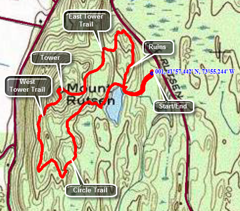
Ferncliff Forest is a privately owned nature and historical preserve near Rhinecliff, NY. The land at one time was owned by the Astors. Presently it has a nice pond, two lean-tos, some ruins, and a tower. The tower is an International Derrick that was relocated from South Carolina several years ago. From Rhinecliff head south on River Road. When the road splits, bear left on Mount Rutsen Road and park in the first lot on your right. From Rhinebeck head north on Route 9. Turn left onto Montgomery Street which becomes Mount Rutsen Road. Drive about 1.8 miles from Route 9 and park at the lot on your left. From the parking area follow the wide road to the pond. There may be brochures at the kiosk near the parking area but maps are hard to come by. East Tower Trail and West Tower Trail both go to the tower but are NOT well marked. Follow a trail or some paths north from the pond and then west and you should run into East Tower Trail. Follow this to the tower. The tower has some fantastic views of the Hudson River, Kingston Rhinecliff Bridge and the Catskills. There are some interesting building below and on the western shore of the river. There is no view from the hill without climbing the tower. Once you have taken in the views and taken some pictures, return to the ground and head south on the West Tower Trail. Heed the sign along the way that tells you to return to the parking area by the Circle Trail. The Circle Trail brings you to the shore of the pond. You may turn left or right to get back to the road that leads back to the car.
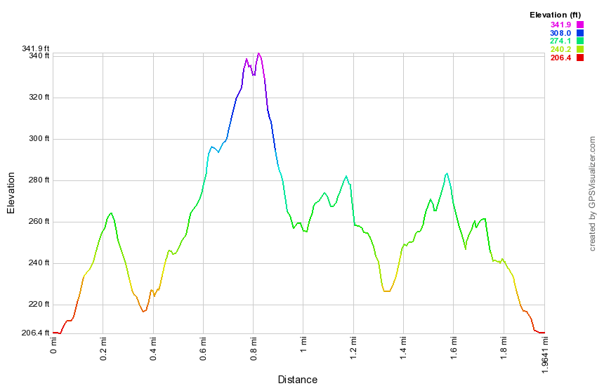
(The image at the left shows the profile of the hike. Remember that all vertical profiles are relative!)
High Falls (Philmont)
| Quick Look | ||||
|---|---|---|---|---|
| Difficulty | Round trip | Total climb | Internet Maps | |
| 1.2 mi. | 240 ft. | AllTrails | ||
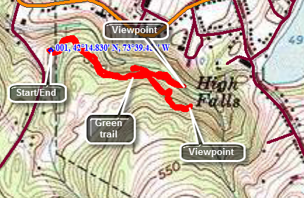 High Falls is located on Roxbury Road in Philmont. Turn south on Roxbury Road from Route 217 which runs through Philmont. The parking area will be several hundred feet along on the left after ascending a small hill. A trail leaves the parking area and crosses a bridge. Stay on the Green Trail which leads to the overlook of the falls. There is also a Blue Trail and a Red Trail in the park. The Red Trail heads more uphill before ending up a the lookout. The Blue Trail is lower and a spur on that trail leads down to an unmarked trail along the stream bed. There is a bench on this trail opposite a small falls. It is possible to scramble along the rocks to get to an area across from the base of High Falls on the other bank of the stream. The viewpoint is quite good and offers a head-on view of the falls which has a drop of over 100 feet.
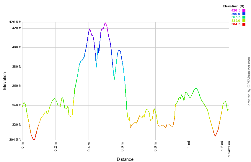
(The image at the left shows the profile of the hike. Remember that all vertical profiles are relative!)
Hudson Highlands: Breakneck Ridge and Mount Taurus
| Quick Look | ||||
|---|---|---|---|---|
| Difficulty | Round trip | Total climb | Internet Maps | |
| 6.2 mi. | 1940 ft. | AllTrails | ||
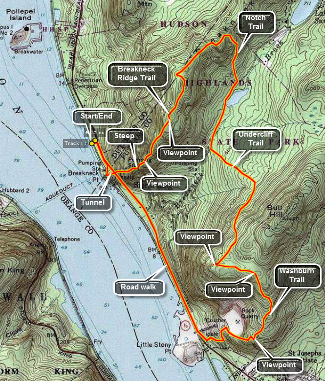 Get on State Route 9D on the east side of the Hudson River. Between Beacon and Cold Spring is a tunnel where the road passes under the railroad tracks. Just north of the tunnel is a parking lot which is often full on the weekends. Park along the road if the lot is filled. Walk south on 9D on the west side of the road. Just before the tunnel is another area to park. Turn off here and follow the trail UP! Your adventure is about to begin!
The first thing you will notice is that the views start immediately! Storm King Mountain is just across the river. Upriver you can see Bannerman Island with its castle. Looking north the United States Military Academy at West point can be seen. As you turn around to walk further up the trail the hike initially seems manageable as you walk through some trees on a dirt trail. As soon as you clear the trees you can see the task ahead of you! The trail rises some 1200 feet in about half a mile. Many of the ascent are just short of technical rope climbs. Using both feet and hands is often necessary. Fortunately, most areas have somewhat easier ascents to the left or right of the main trail. As you climb there are places to stop and rest. These spots also afford excellent viewpoints over the Hudson and the surrounding areas. There are several places where you will be sure you are at the top until you look a little further on and there is another ascent. In most cases there is a slight descent before the next ascent making things more interesting. Finally the trail winds its way around the last part of the mountain fairly close to the edge and makes the last ascent. The top here is fairly flat with plenty of areas to stop and get a snack and marvel at the views!
The trail continues on in a northeast direction toward Sunset Point and South Beacon Mountain. The tower has been completely restored and is safe to climb to the cab. The steps, landings and cab floor are all open grid steel which can be a little disconcerting but perfectly safe. The entire hike is long and would be difficult to complete for some ! As you hike the trail goes through a series of rolling ascents and descents. Shortly after the "top" of the initial, steep climb is a trail to the left. This is the Breakneck Ridge Bypass Trail and offers the first opportunity to shorten the hike. Continuing on the trail there are several places where the paint marking are faint and where woods roads invitingly cross the trail. Stay on the Breakneck Ridge Trail as many of these other side routes take you FAR away from where you want to be. The next cutoff is the Notch trail which leads off to the right and down the ridge back toward Route 9D and Cold Spring. Turn right on the Notch Trail and begin to descend through several switchbacks and passed some impressive cliffs on the right. The trail leads through an open forest to the pond just north of the Cornish dairy barn just .5 miles from the start of the trail. Continue on down the trail for another .2 miles where the Undercliff-Overcliff Trail crosses. Turn left to go up and over Mount Taurus. This trail is seldom steep but ascends until it reaches its highest point on Bull Hill. At times it follows woods roads. In several places the walls that shored up the sides of the road are visible and in very good shape. Several switchbacks make the climb easier until after about 1 mile several viewpoints open up near the highest point on the trail.
Continue on this trail as it heads east and then south down Bull Hill. There are lookouts along this trail down into Cold Spring and across the river to West Point. You will pass by the quarry on your right and then descend an old road to the Little Stony Point parking area on Route 9D with the scariest part of the hike yet to come. Walk along Route 9D for 1.25 miles. There is NO SHOULDER and cars travel MUCH TOO FAST! Near the end of the trip walk through the tunnel to arrive back at your car after about 6.25 miles of hiking.
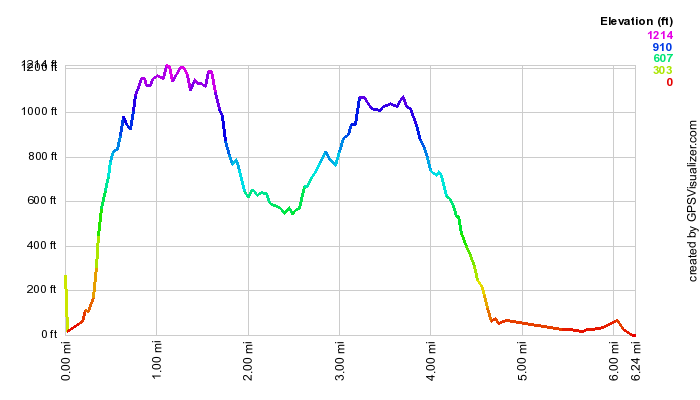
(The image at the left shows the profile of the hike. Remember that all vertical profiles are relative!)
Hudson Highlands: Breakneck Ridge and Little Stony Point
| Quick Look | ||||
|---|---|---|---|---|
| Difficulty | Round trip | Total climb | Internet Maps | |
| 6.0 mi. | 1690 ft. | AllTrails | ||
 WARNING: This hike requires two cars or a walk along busy Route 9D which as no shoulder. Get on State Route 9D on the east side of the Hudson River. Between Beacon and Cold Spring is a tunnel where the road passes under the railroad tracks. Just north of the tunnel is a parking lot which is often full on the weekends. Continue on Route 9D to the parking area for Little Stony Point and Mount Taurus. Park one car here and then head north again to the tunnel. Park along the road if the lot is filled. Walk south on 9D on the west side of the road. Just before the tunnel is another area to park. Turn off here and follow the trail UP! Your adventure is about to begin!
The first thing you will notice is that the views start immediately! Storm King Mountain is just across the river. Upriver you can see Bannerman Island with its castle. Looking north the United States Military Academy at West point can be seen. As you turn around to walk further up the trail the hike initially seems manageable as you walk through some trees on a dirt trail. As soon as you clear the trees you can see the task ahead of you! The trail rises some 1200 feet in about half a mile. Many of the ascent are just short of technical rope climbs. Using both feet and hands is often necessary. Fortunately, most areas have somewhat easier ascents to the left or right of the main trail. As you climb there are places to stop and rest. These spots also afford excellent viewpoints over the Hudson and the surrounding areas. There are several places where you will be sure you are at the top until you look a little further on and there is another ascent. In most cases there is a slight descent before the next ascent making things more interesting. Finally the trail winds its way around the last part of the mountain fairly close to the edge and makes the last ascent. The top here is fairly flat with plenty of areas to stop and get a snack and marvel at the views!
The trail continues on in a northeast direction toward Sunset Point and South Beacon Mountain. The first side trail you pass is the yellow Undercliff Trail on the right followed by the red Bypass Trail on the right. Continue passed both of these to the blue Cornish Trail on the right. Descend this trail to the area of a pond and an old barn. This farm was associated with the Cornish Estate further down the trail. The barn is very interesting. Follow the Cornish Trail down to the river as it widens and becomes a paved driveway for the former Cornish Estate. A large cistern appears on the right and then the remains of a greenhouse. Walk down the driveway to the greenhouse. Not too much father along are the remains of the main house which was ravaged by fire. Vegetation and vines have recaptured most of the structure giving it a surreal appearance. The paved driveway continues down parallel to the river and the railroad tracks until it ends at a gate on Route 9D. Keep on the path as it winds its way back to the parking lots.
At the parking area, take the time to walk around Little Stony Point. This is an area of land that pushes out into the Hudson. Try turning right after crossing over the train tracks. This path will take you to a beautiful sandy beach right on the Hudson with incredible views north toward Storm King, Breakneck ridge and Pollepel Island. Continue on around the point in a counterclockwise direction. Take in the views as they change from north to west and then south. The fact that you are at river level gives an entirely different feel than viewing the same area from "above". As you walk notice the large rock outcropping on you left. This makes an excellent vantage point. Continue on around to the point where you started. Just as you see the footbridge over the tracks there is a trail to the left that leads to the top of the rock outcrop. It is an easy walk with only a few rough spots. Your reward are some beautiful views of the river below. When you are done looking up and down the river, retrace your steps to the car.
(The image at the left shows the profile of the hike. Remember that all vertical profiles are relative!)
Hudson Highlands: Breakneck Ridge to Bypass Trail
| Quick Look | ||||
|---|---|---|---|---|
| Difficulty | Round trip | Total climb | Internet Maps | |
| 3.2 mi. | 1433 ft. | AllTrails | ||
 Get on State Route 9D on the east side of the Hudson River. Between Beacon and Cold Spring is a tunnel where the road passes under the railroad tracks. Just north of the tunnel is a parking lot which is often full on the weekends. Park along the road if the lot is filled. Walk south on 9D on the west side of the road. Just before the tunnel is another area to park. Turn off here and follow the trail UP! Your adventure is about to begin!
The first thing you will notice is that the views start immediately! Storm King Mountain is just across the river. Upriver you can see Bannerman Island with its castle. Looking north the United States Military Academy at West point can be seen. As you turn around to walk further up the trail the hike initially seems manageable as you walk through some trees on a dirt trail. As soon as you clear the trees you can see the task ahead of you! The trail rises some 1200 feet in about half a mile. Many of the ascent are just short of technical rope climbs. Using both feet and hands is often necessary. Fortunately, most areas have somewhat easier ascents to the left or right of the main trail. As you climb there are places to stop and rest. These spots also afford excellent viewpoints over the Hudson and the surrounding areas. There are several places where you will be sure you are at the top until you look a little further on and there is another ascent. In most cases there is a slight descent before the next ascent making things more interesting. Finally the trail winds its way around the last part of the mountain fairly close to the edge and makes the last ascent. The top here is fairly flat with plenty of areas to stop and get a snack and marvel at the views!
Just after the summit the trail start to descend and the Breakneck Bypass Trail turns left. Turn here and be ready to keep turning sharply to the left as the Bypass Trail makes nearly a 180 degrees turn to parallel the Breakneck Ridge trail before heading a little more north and down the ridge. The trail descends almost 800 feet over the next .7 miles to a junction with the Wilkinson Trail. Turn left on a woods road and walk less than .5 miles to Route 9D. Turn left on Route 9D and walk the .15 miles back to the parking area.
(The image at the left shows the profile of the hike. Remember that all vertical profiles are relative!)
Hudson Highlands: Breakneck Ridge to South Beacon Mountain
| Quick Look | ||||
|---|---|---|---|---|
| Difficulty | Round trip | Total climb | Internet Maps | |
| 8.2 mi. | 2995 ft. | AllTrails | ||
The first thing you will notice is that the views start immediately! Storm King Mountain is just across the river. Upriver you can see Bannerman Island with its castle. Looking north the United States Military Academy at West point can be seen. As you turn around to walk further up the trail the hike initially seems manageable as you walk through some trees on a dirt trail. As soon as you clear the trees you can see the task ahead of you! The trail rises some 1200 feet in about half a mile. Many of the ascent are just short of technical rope climbs. Using both feet and hands is often necessary. Fortunately, most areas have somewhat easier ascents to the left or right of the main trail. As you climb there are places to stop and rest. These spots also afford excellent viewpoints over the Hudson and the surrounding areas. There are several places where you will be sure you are at the top until you look a little further on and there is another ascent. In most cases there is a slight descent before the next ascent making things more interesting. Finally the trail winds its way around the last part of the mountain fairly close to the edge and makes the last ascent. The top here is fairly flat with plenty of areas to stop and get a snack and marvel at the views!
The trail continues on in a northeast direction toward Sunset Point and South Beacon Mountain. The tower has been completely restored and is safe to climb to the cab. The steps, landings and cab floor are all open grid steel which can be a little disconcerting but perfectly safe. The entire hike is long and would be difficult to complete for some ! As you hike the trail goes through a series of rolling ascents and descents. Shortly after the "top" of the initial, steep climb is a trail to the left. This is the Breakneck Ridge Bypass Trail and offers the first opportunity to shorten the hike. Continuing on the trail there are several places where the paint marking are faint and where woods roads invitingly cross the trail. Stay on the Breakneck Ridge Trail as many of these other side routes take you FAR away from where you want to be. The next cutoff is the Notch trail which leads off to the right and down the ridge back toward Route 9D and Cold Spring. Bear left here to stay on the Breakneck Ridge Trail.
After a few miles the trail forks with a blue trail heading left. You may take this trail but continuing on for less than half a mile will bring you to Sunset Point. At Sunset Point a wooden observation platform looks out over the Hudson River. The view is somewhat the same as from other parts of the ridge. After taking in the view, return to the white Breakneck Ridge Trail north. In less than half a mile this trail intersects the yellow Wilkinson Memorial Trail. Turn right and follow both trails up an old woods road. After only a few hundred feet the white trail turns left and proceeds straight up the mountain. Turn left and get prepared for some more steep rock scrambles. After the first, most strenuous scramble, the trail levels some and continues to the fire tower. Along the way there are some nice lookouts but none compare to the summit vantage point.
The tower has been completely restored and is safe to climb to the cab. The steps, landings and cab floor are all open grid steel which can be a little disconcerting but perfectly safe. The summit is completely treeless and offers a 360 degree unimpeded view in all directions. Up river the Mid-Hudson Bridge can be seen. On a clear day New York City can be seen to the south. Walk around on the summit ridge to get the best views before turning back to retrace your steps. Use caution as you descend the rock scrambles you came up. At the Wilkinson Trail turn right and walk back down to where the Breakneck Ridge Trail parts from the Wilkinson Trail. This time turn right and stay on the yellow Wilkinson Trail to offer some variety. Alternatively follow the white Breakneck Ridge Trail back to Sunset Point and to the Wilkinson Trail from there.
The Wilkinson memorial Trail drops down to Squirrel Hollow Brook where it meets the blue Notch Trail. You could turn right and follow the Notch Trail out to Route 9D but this leaves more than a mile of walking along a busy highway. Turn left and follow the Wilkinson and Notch Trail for a little more than half a mile on a slightly uphill trek. At this point the Wilkinson Trail makes a sharp right and separates from the Notch Trail. Turn right to head back to where you parked the car. This trail heads mostly downward toward the river for about three miles. It has varied terrain through small clearings and darker forests. In the last mile there is a slight climb to the open summit of Sugarloaf Mountain. From here the trail descends sharply for several hundred feet. After this the trail continues to descend but the pitch moderates some and this is aided by several switchbacks at the upper end. The further you descend the gentler the pitch becomes until the trail ends abruptly on Route 9D less than a half mile north of where you parked.
(The image at the left shows the profile of the hike. Remember that all vertical profiles are relative!)
Hudson Highlands: Breakneck Ridge to Sunset Point
| Quick Look | ||||
|---|---|---|---|---|
| Difficulty | Round trip | Total climb | Internet Maps | |
| 6.0 mi. | 2100 ft. | AllTrails | ||
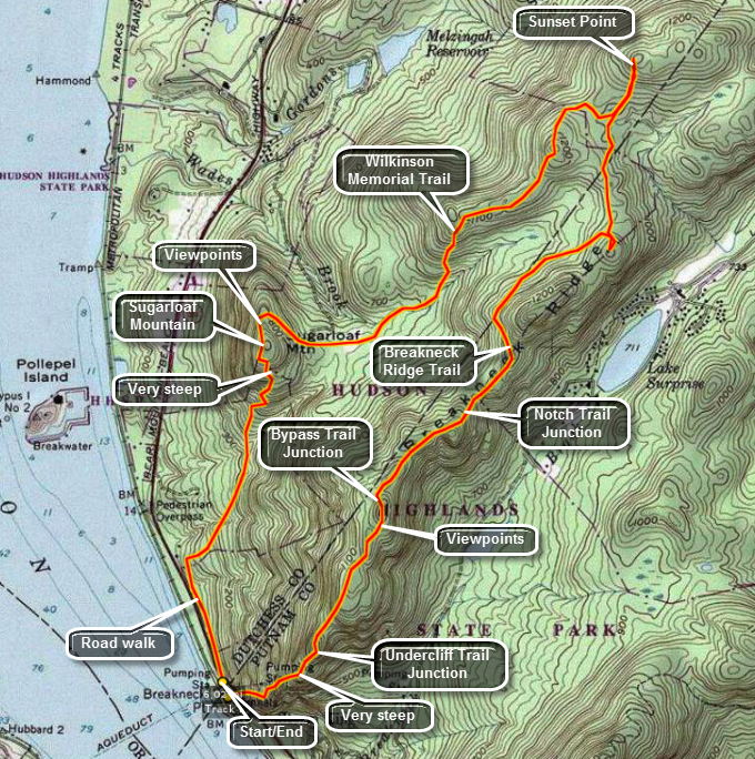 Get on State Route 9D on the east side of the Hudson River. Between Beacon and Cold Spring is a tunnel where the road passes under the railroad tracks. Just north of the tunnel is a parking lot which is often full on the weekends. Park along the road if the lot is filled. Walk south on 9D on the west side of the road. Just before the tunnel is another area to park. Turn off here and follow the trail UP! Your adventure is about to begin!
The first thing you will notice is that the views start immediately! Storm King Mountain is just across the river. Upriver you can see Bannerman Island with its castle. Looking north the United States Military Academy at West point can be seen. As you turn around to walk further up the trail the hike initially seems manageable as you walk through some trees on a dirt trail. As soon as you clear the trees you can see the task ahead of you! The trail rises some 1200 feet in about half a mile. Many of the ascent are just short of technical rope climbs. Using both feet and hands is often necessary. Fortunately, most areas have somewhat easier ascents to the left or right of the main trail. As you climb there are places to stop and rest. These spots also afford excellent viewpoints over the Hudson and the surrounding areas. There are several places where you will be sure you are at the top until you look a little further on and there is another ascent. In most cases there is a slight descent before the next ascent making things more interesting. Finally the trail winds its way around the last part of the mountain fairly close to the edge and makes the last ascent. The top here is fairly flat with plenty of areas to stop and get a snack and marvel at the views!
The trail continues on in a northeast direction toward Sunset Point and South Beacon Mountain. The tower has been completely restored and is safe to climb to the cab. The steps, landings and cab floor are all open grid steel which can be a little disconcerting but perfectly safe. The entire hike is long and would be difficult to complete for some! As you hike the trail goes through a series of rolling ascents and descents. Shortly after the "top" of the initial, steep climb is a trail to the left. This is the Breakneck Ridge Bypass Trail and offers the first opportunity to shorten the hike. Continuing on the trail there are several places where the paint marking are faint and where woods roads invitingly cross the trail. Stay on the Breakneck Ridge Trail as many of these other side routes take you FAR away from where you want to be. The next cutoff is the Notch trail which leads off to the right and down the ridge back toward Route 9D and Cold Spring. Bear left here to stay on the Breakneck Ridge Trail.
After a few miles the trail forks with a blue trail heading left. You may take this trail but continuing on for less than half a mile will bring you to Sunset Point. At Sunset Point a wooden observation platform looks out over the Hudson River. The view is somewhat the same as from other parts of the ridge. After taking in the view, turn around and head back to where the blue trail split off. After only a few hundred feet on the blue trail, the yellow blazes of the Wilkinson Memorial Trail show up on the left. Turn here to head back to where you parked the car. This trail heads mostly downward toward the river for about three miles. It has varied terrain through small clearing and darker forests. In the last mile there is a slight climb to the open summit of Sugarloaf Mountain. From here the trail descends sharply for several hundred feet. After this the trail continues to descend but the pitch moderates some and this is aided by several switchbacks at the upper end. The further you descend the gentler the pitch becomes until the trail ends abruptly on Route 9D less than a half mile north of where you parked.
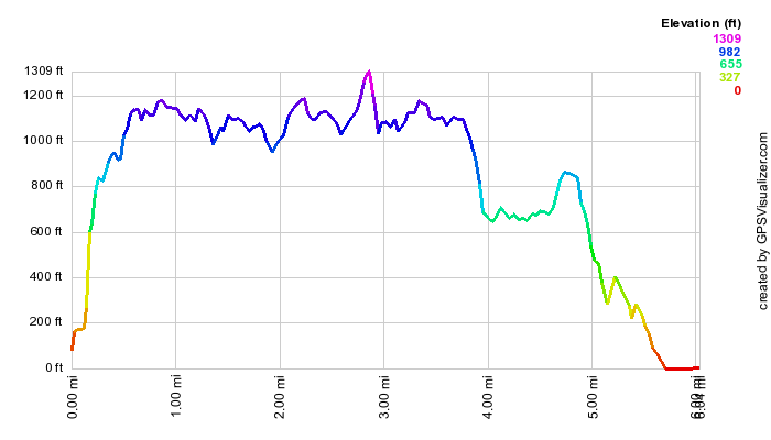
(The image at the left shows the profile of the hike. Remember that all vertical profiles are relative!)
Hudson Highlands: Canada Hill
| Quick Look | ||||
|---|---|---|---|---|
| Difficulty | Round trip | Total climb | Internet Maps | |
| 9.0 mi. | 2130 ft. | AllTrails | ||
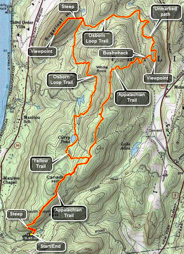 Get on State Route 9D on the east side of the Hudson River. Drive to a point just north of the Bear Mountain Bridge. Turn east on South Mountain Pass Road. About .7 miles up this narrow, dirt road is a small parking area on the right. The Appalachian Trail crosses here. Walk up the road and turn left into the woods to start the hike on the Appalachian Trail.
The first .2 miles of the trail are a little steep going about 160 feet. After this, the AT turns right and continued to climb steeply for another .2 miles gaining around 300 feet from the start of the hike. In several places the trail blazes all but disappear so that staying on the trail is difficult. Once you are up on the ridge the trail becomes a wide woods road for some distance. There aren't too many views from the ridge but the open forest especially near the top of Canada Hill is very pretty. You will pass by Canada Hill at about .8 miles and the trail continues toward the northeast. Around .9 miles, the Osborn Loop Trail appears on the right but you should stay on the AT. At 1.3 miles, a yellow trail comes in from the left but you should continue on the AT. Along the way there may seem to be the possibility of some viewpoints but all are blocked by trees. At 2.4 miles, the blue trail appears straight ahead and the AT turns right. Turn on the AT and start down off the ridge. Watch for the yellow Carriage Connector Trail which is further down the hill than you might expect. The yellow trail lies on a wide woods "road" that heads north where an unmarked path turns right and to the south to get to the White Rock lookout. The problem is that you have to hike more than a half mile north to pick up the path and then back a half mile on the path to the viewpoint. Since the viewpoint is just above the junction of the AT and the yellow trail it is possible to bushwhack up to the path and save some useless backtracking. Turn right off the trail and begin a rather steep ascent through some brush that can be thick at times. The path lies between the first climb and the cliffs directly ahead! Turn right on the path and hike to the top of the hill and to the viewpoint. The viewpoint looks south across Camp Smith, Anthony's Nose and the Hudson. When you are done, hike around the hill on the path. When the path gibes out, bushwhack down the hill and pick up the path again. Follow the path which follows a road back to the yellow trail.
As you walk along the yellow trail, notice that the road is supported by a stone wall on the right side. The construction is old but has stood the test of time. Further along the stone wall support changes to the left side of the trail where a stream would have cut into the road. The wall is higher and much more impressive here. The yellow trail ends at about 4.3 miles and you should continue straight ahead on the blue trail. Almost immediately you will see stone pillars with pipe railing on the left side of the road near a 90 degree turn. The pillars have depressions on top that act as planters. On a small hill to the right of the trail is a wooden gazebo with a stone foundation. It seems that the east side of the Hudson always "had money". As you continue the hike you will come to a junction with a red trail to Sugarloaf Hill. The trail is a dead end and the climb is short but steep gaining 200 foot over .2 miles. After the climb, the trail flattens and it is another .25 miles to the end of the hill and the viewpoint. The lookout points south and there are a few annoying trees in the way. The Bear Mountain Bridge is visible but it seems pretty far away! When you are done, head back down the hill. At the trail junction, turn right and head out on the trail at 5.5 miles into the hike. The blue trail runs between the hills and along a brook but at about 6 miles it starts to climb the ridge again. At 7.0 miles continue on the yellow trail toward Curry Pond. Curry Pond is small but pretty. Walk around the pond and follow the yellow trail as it starts the final ascent back to the AT on the ridge. The trail passes through some dense laurel, crosses a small stream and then makes a short but steep ascent through a cleft in the rock ledge. It flattens at the top and at 7.8 miles you will be back on the AT. There is about 1.3 miles of hiking left to get back to the car.
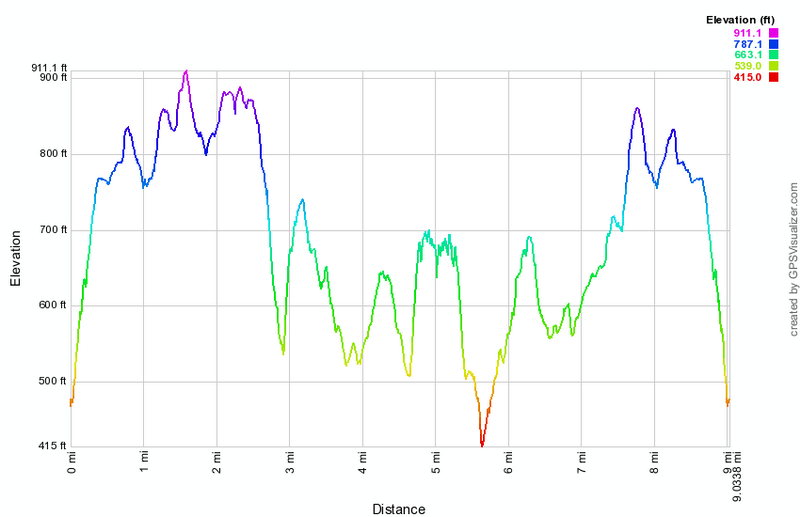
(The image at the left shows the profile of the hike. Remember that all vertical profiles are relative!)
Hudson Highlands: Fishkill Ridge - Overlook Trail to Lambs Hill
| Quick Look | ||||
|---|---|---|---|---|
| Difficulty | Round trip | Total climb | Internet Maps | |
| 4.3 mi. | 1635 ft. | AllTrails | ||
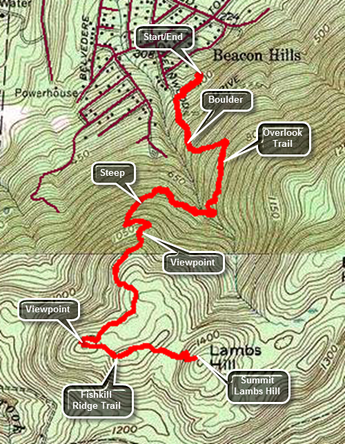 Take I84 to exit 12. Follow Route 52 west for .2 miles from I84 to Old Glenham Road. Turn left and after .9 miles turn left on Maple Street. Follow it as it becomes Washington Avenue. Turn left on Old Town Road and drive .4 miles to Sunnyside Road. Drive to the end of Sunnyside Road and turn left into the well-marked parking area. To begin the hike walk out the far end of the parking area passing a kiosk with some interesting information about the Fishkill Ridge. The first part of the trail is a woods road that begins with a gentle grade. The trail soon turns left and begins to parallel a deep ravine to the right as it starts to climb. At around .3 miles there is a large conglomerate boulder. Just after the boulder the trail turns left away from the ravine and continues to climb with grades over 20%. Soon the trail abruptly turns right heading back toward the ravine. Walk on the level for a short distance and then walk downhill to cross the ravine. After crossing the small creek in the ravine, make a sharp right and start to climb. The trail is well marked which is fortunate since there are many paths and woods roads that cross the trail at different spots. You will begin to see some views of the Hudson River through the trees and begin to wonder if you will ever get any clear views. At about 1.1 miles begin to ascend an open rock face. Looking back over your shoulder will reveal an amazing open view of the Hudson River! Walk a little farther to the top of the climb and stop to take in the view. At 1.4 miles the trail levels a little and rolls some until at 1.7 miles there is another nice overlook. Walk to the top of the hill where the Overlook Trail ends at the white Fishkill Ridge Trail. Turn left to head toward Lambs Hill. Over the next .3 miles you will descend one small hill and climb another until at 2.0 miles you will be at the base of Lambs Hill. The trail heads straight for a cliff and then parallels the cliff before making a sharp right to go over the top. After climbing over the cliff, climb up an open rock face to the top of Lamb's Hill. There are some nice views from the top of the hill including the Hudson to the west and the Beacon Reservoir hidden in the trees to the southwest. When you are done, turn around and retrace your route to the car. Be careful on the downhill especially when there are leaves, ice or snow on the trails!
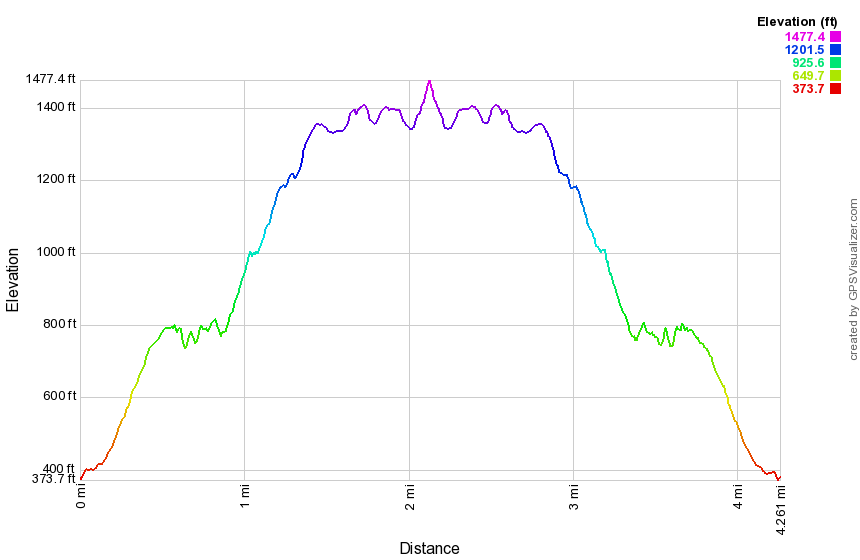
(The image at the left shows the profile of the hike. Remember that all vertical profiles are relative!)
Hudson Highlands: Fishkill Ridge - Pocket Road to Fishkill Flag
| Quick Look | ||||
|---|---|---|---|---|
| Difficulty | Round trip | Total climb | Internet Maps | |
| 5.1 mi. | 2025 ft. | AllTrails | ||
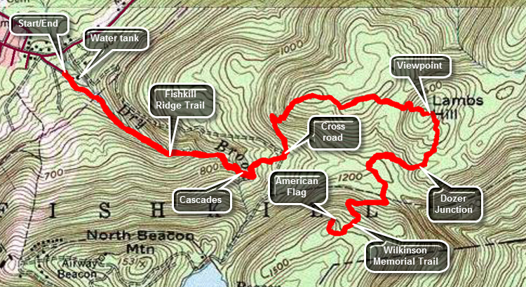 Take I84 to exit 11. Head south on Route 9D and turn left on Main St. Follow it to E Main Street. Turn right and follow East Main St to Pocket Road which is a dead end. Near the end is a gate that controls access to part of the City of Beacon's water supply. Park in the turnout just before the gate where the number of parking spaces is very limited. Walk through the gate and up the access road which passes by a large water storage tank and then a small reservoir. After the reservoir, the trail begins to follow Dry Brook which and trail grade averages about 15% with some steeper spots. There were several spots on the trail that are eroded and others than require walking along slanted rocks which ay be difficult when the trail is wet or icy or covered in snow. You will cross Dry Brook several times and at .75 miles there is a final crossing. we crossed it for the last time as we continued east. At this point the brook is flowing from the south out of Beacon Reservoir and there is a series of cascades with a waterfall at the top. Continue walking east on the trail, gaining elevation until the trail crosses the road to the reservoir at .9 miles. Turn left on the road and then almost immediately right into the forest. Follow the trail as it begins to ascend an unnamed hill. Over the next .3 miles gain 380 feet making an average grade of 24% despite the switchbacks! At 1.2 mile you will arrive at the junction with the Overlook Trail that ascends from the Sunnyside Road trailhead. Continue heading east as the trail rolls over several small hills before climbing to the top of Lambs Hill at 1.7 miles. The trail goes over the top of Lambs Hill and descends the other side to Dozer Junction at 1.9 miles. Dozer Junction gets its name from a bulldozer parked at the junction. The white Fishkill Ridge Trail continues straight ahead. Turn right on a short blue connector trail. At 2.2 miles there is a low spot and then the junction with the yellow Wilkinson Memorial Trail. Turned right to follow the trail to the southwest and start to watch for an unmarked trail to the hill with the flag. At 2.5 miles the Wilkinson Memorial Trail makes a sharp left heading eastward. Continue straight ahead and turn right on an unmarked but prominent trail. Walk uphill staying right at a fork in the path and you will see the flag ahead just over the top of the hill. When you have taken in the view, retrace your route back to the car. Be careful on the descent since wet conditions and slippery leave scan make the down harder than the up! Of, course there are many other options. Perhaps the best one is to hike out the Fishkill Ridge on the white trail. This will add about 3 miles to your hike and there are some nice views along t5he way!
When you are done, turn around and retrace your route to the car. Be careful on the downhill especially when there are leaves, ice or snow on the trails!
Take I84 to exit 11. Head south on Route 9D and turn left on Main St. Follow it to E Main Street. Turn right and follow East Main St to Pocket Road which is a dead end. Near the end is a gate that controls access to part of the City of Beacon's water supply. Park in the turnout just before the gate where the number of parking spaces is very limited. Walk through the gate and up the access road which passes by a large water storage tank and then a small reservoir. After the reservoir, the trail begins to follow Dry Brook which and trail grade averages about 15% with some steeper spots. There were several spots on the trail that are eroded and others than require walking along slanted rocks which ay be difficult when the trail is wet or icy or covered in snow. You will cross Dry Brook several times and at .75 miles there is a final crossing. we crossed it for the last time as we continued east. At this point the brook is flowing from the south out of Beacon Reservoir and there is a series of cascades with a waterfall at the top. Continue walking east on the trail, gaining elevation until the trail crosses the road to the reservoir at .9 miles. Turn left on the road and then almost immediately right into the forest. Follow the trail as it begins to ascend an unnamed hill. Over the next .3 miles gain 380 feet making an average grade of 24% despite the switchbacks! At 1.2 mile you will arrive at the junction with the Overlook Trail that ascends from the Sunnyside Road trailhead. Continue heading east as the trail rolls over several small hills before climbing to the top of Lambs Hill at 1.7 miles. The trail goes over the top of Lambs Hill and descends the other side to Dozer Junction at 1.9 miles. Dozer Junction gets its name from a bulldozer parked at the junction. The white Fishkill Ridge Trail continues straight ahead. Turn right on a short blue connector trail. At 2.2 miles there is a low spot and then the junction with the yellow Wilkinson Memorial Trail. Turned right to follow the trail to the southwest and start to watch for an unmarked trail to the hill with the flag. At 2.5 miles the Wilkinson Memorial Trail makes a sharp left heading eastward. Continue straight ahead and turn right on an unmarked but prominent trail. Walk uphill staying right at a fork in the path and you will see the flag ahead just over the top of the hill. When you have taken in the view, retrace your route back to the car. Be careful on the descent since wet conditions and slippery leave scan make the down harder than the up! Of, course there are many other options. Perhaps the best one is to hike out the Fishkill Ridge on the white trail. This will add about 3 miles to your hike and there are some nice views along t5he way!
When you are done, turn around and retrace your route to the car. Be careful on the downhill especially when there are leaves, ice or snow on the trails!
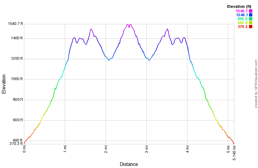
(The image at the left shows the profile of the hike. Remember that all vertical profiles are relative!)
Hudson Highlands: Fishkill Ridge - Route 9 to Fishkill Flag
| Quick Look | ||||
|---|---|---|---|---|
| Difficulty | Round trip | Total climb | Internet Maps | |
| 7.2 mi. | 1850 ft. | AllTrails | ||
 Take I84 to exit 13. Head south on Route 9 for 3 miles and watch for Old Albany Post Road on the right. Turn right and drive about a quarter mile to Reservoir Road on the right. Notice the three yellow disks on the telephone pole at the end of the road indicating the beginning of the Wilkinson Memorial Trail. Finding a place to park can be a problem. Although there is a public right-of-way on all the streets and roads the local residents seem to be adverse to parking on the side of the road. An alternative plan is to park at Nicola's Restaurant on Route 9. Be sure to ask for permission to park and to park as far away from the restaurant as possible. From the parking lot, cross Route 9 and turn left. Walk to Old Albany Post Road and turn left. Walk to Reservoir Road and turn right to begin the hike on the trail. After a short distance, there is a gate blocking the road and to the right is a DEC facility. Pass through the gate and start into the forest starting the climb toward the ridge heading west. Noticed that the trees in this area are huge both in height and in girth. Some are so large that they appear to be first growth. At .9 miles there is a small reservoir or lake. Walk around to the north shore following the trail to continue the hike. The trees actually seemed to be bigger on the north side of the lake. From the lake to 1.45 miles the trail is almost flat rolling a little but after that it begins to climb. At 1.6 miles there are some switchbacks which make the climb a little easier. The grade still averages 19% until the Fishkill Ridge at 2 miles. At this point the Wilkinson memorial Trail turns left. Head right on the white Fishkill Ridge Trail. Walk on the trail following it northeast as it actually descends some until a stream crossing at 2.8 miles. Along the way notice some fantastic stone walls. Many maps indicate viewpoints along the trail but most are now blocked by trees. Don't worry as there are better views ahead on the trail. At 2.8 miles begin to climb still heading northeast. There are more stone walls and other evidence the area was settled at some time. At 3.0 miles the trail begins a sweeping turn to the north and at 3.3 miles it makes a sharp turn heading southwest but still gaining elevation. As you climb, you will see you are approaching an open vista. Soon the trail reaches the top of Bald Hill, the highest point on the hike at 1490 feet, with an almost 360 degree view. Although this elevation pales in comparison to the Catskills it is over 1200 feet above the valley. The views are fantastic in all directions. Perhaps the most surprising sight is a small table and rustic rocking chair on the top of the hill. In the valley to the east of the ridge there is a massive sand and gravel operation with terraces cut into the hill. Walk a little farther for some different angles of the same views. From the top of the hill the rest of the hike is mostly downhill with a few small climbs along the way but no more significant viewpoints. At 4.6 miles there is an open rock that at one point may have had a view. The trail heads down off the rock to the south and then loops clockwise around the rock ending up in a short but tricky descent to Dozer Junction. The junction is named for a bulldozer that sits at the junction. I have been unable, despite several research attempts, to find out why the bulldozer was abandoned there. Turn left on the blue trail and head downhill to the yellow Wilkinson Memorial Trail. Along the way watch for more stone walls, several foundations, extensive woods roads and some farm equipment including disk and spring-tooth harrows. Turn left at the yellow trail to follow the trail back to the car. Part of the trail is relatively narrow with a high rock wall on the left and a dropoff on the right. The trail goes up and over some rocks. At 5.4 miles you will be back at the junction with the Fishkill Ridge Trail. Turn right to stay on the yellow Wilkinson Memorial Trail. The descent goes quickly and once you are back at the trailhead retrace your route back to the car
When you are done, turn around and retrace your route to the car. Be careful on the downhill especially when there are leaves, ice or snow on the trails!
Take I84 to exit 13. Head south on Route 9 for 3 miles and watch for Old Albany Post Road on the right. Turn right and drive about a quarter mile to Reservoir Road on the right. Notice the three yellow disks on the telephone pole at the end of the road indicating the beginning of the Wilkinson Memorial Trail. Finding a place to park can be a problem. Although there is a public right-of-way on all the streets and roads the local residents seem to be adverse to parking on the side of the road. An alternative plan is to park at Nicola's Restaurant on Route 9. Be sure to ask for permission to park and to park as far away from the restaurant as possible. From the parking lot, cross Route 9 and turn left. Walk to Old Albany Post Road and turn left. Walk to Reservoir Road and turn right to begin the hike on the trail. After a short distance, there is a gate blocking the road and to the right is a DEC facility. Pass through the gate and start into the forest starting the climb toward the ridge heading west. Noticed that the trees in this area are huge both in height and in girth. Some are so large that they appear to be first growth. At .9 miles there is a small reservoir or lake. Walk around to the north shore following the trail to continue the hike. The trees actually seemed to be bigger on the north side of the lake. From the lake to 1.45 miles the trail is almost flat rolling a little but after that it begins to climb. At 1.6 miles there are some switchbacks which make the climb a little easier. The grade still averages 19% until the Fishkill Ridge at 2 miles. At this point the Wilkinson memorial Trail turns left. Head right on the white Fishkill Ridge Trail. Walk on the trail following it northeast as it actually descends some until a stream crossing at 2.8 miles. Along the way notice some fantastic stone walls. Many maps indicate viewpoints along the trail but most are now blocked by trees. Don't worry as there are better views ahead on the trail. At 2.8 miles begin to climb still heading northeast. There are more stone walls and other evidence the area was settled at some time. At 3.0 miles the trail begins a sweeping turn to the north and at 3.3 miles it makes a sharp turn heading southwest but still gaining elevation. As you climb, you will see you are approaching an open vista. Soon the trail reaches the top of Bald Hill, the highest point on the hike at 1490 feet, with an almost 360 degree view. Although this elevation pales in comparison to the Catskills it is over 1200 feet above the valley. The views are fantastic in all directions. Perhaps the most surprising sight is a small table and rustic rocking chair on the top of the hill. In the valley to the east of the ridge there is a massive sand and gravel operation with terraces cut into the hill. Walk a little farther for some different angles of the same views. From the top of the hill the rest of the hike is mostly downhill with a few small climbs along the way but no more significant viewpoints. At 4.6 miles there is an open rock that at one point may have had a view. The trail heads down off the rock to the south and then loops clockwise around the rock ending up in a short but tricky descent to Dozer Junction. The junction is named for a bulldozer that sits at the junction. I have been unable, despite several research attempts, to find out why the bulldozer was abandoned there. Turn left on the blue trail and head downhill to the yellow Wilkinson Memorial Trail. Along the way watch for more stone walls, several foundations, extensive woods roads and some farm equipment including disk and spring-tooth harrows. Turn left at the yellow trail to follow the trail back to the car. Part of the trail is relatively narrow with a high rock wall on the left and a dropoff on the right. The trail goes up and over some rocks. At 5.4 miles you will be back at the junction with the Fishkill Ridge Trail. Turn right to stay on the yellow Wilkinson Memorial Trail. The descent goes quickly and once you are back at the trailhead retrace your route back to the car
When you are done, turn around and retrace your route to the car. Be careful on the downhill especially when there are leaves, ice or snow on the trails!
(The image at the left shows the profile of the hike. Remember that all vertical profiles are relative!)
Hudson Highlands: Mount Beacon and Scofield Overlook
| Quick Look | ||||
|---|---|---|---|---|
| Difficulty | Round trip | Total climb | Internet Maps | |
| 5.3 mi. | 1730 ft. | AllTrails | ||
(The image shows the profile of the hike. Remember that all vertical profiles are relative!)
Hudson Highlands: Mount Beacon and Scofield Ridge
| Quick Look | ||||
|---|---|---|---|---|
| Difficulty | Round trip | Total climb | Internet Maps | |
| 7.3 mi. | 2590 ft. | AllTrails | ||
At about 4.4 miles the yellow Wilkinson Trail takes a hard right and starts to descend off the ridge. Turn left on a blue trail but avoid the white Fishkill Ridge Trail which extends out along Fishkill Ridge. The blue trail is short and at 4.7 miles you will be at Dozer Junction where the blue trail ends at the white Fishkill Ridge Trail that has looped around the ridge. Dozer Junction is aptly named since there is a bulldozer at the meeting of the trails. Turn left on the white Fishkill Ridge Trail as it ascends Lambs Hill for some more views. At 5.5 miles there will be another lookout and a junction with the red Overlook Trail. Stay to the left and continue to follow the white trail down the ridge. At around 5.7 miles you will cross over a road that goes to the Beacon Reservoir. The trail marking can be confusing here so look across the road to pick up the blazes and continue on the trail. For the next .5 miles the trail runs along a stream and there may be some waterfalls on the stream and the small tributaries depending on the volume of water. At 6.1 miles the white trail continues to the right. Bear left on the yellow Wilkinson Trail which will return you on a woods road to the top of the stairs which lead back down to the parking lot.
(The image at the left shows the profile of the hike. Remember that all vertical profiles are relative!)
Hudson Highlands: Mount Taurus and Little Stony Point
| Quick Look | ||||
|---|---|---|---|---|
| Difficulty | Round trip | Total climb | Internet Maps | |
| 5.6 mi. | 1525 ft. | AllTrails | ||
 Get on State Route 9D on the east side of the Hudson River. Between Beacon and Cold Spring is a tunnel where the road passes under the railroad tracks. Just south of the tunnel there are parking lots on both sides of the road at Little Stony Point. They are often full on the weekends. Park along the road if the lots are filled. The white blazed Washburn Trail leaves from the north end of the parking lot on the east side of the road. The trail starts as a rather broad road and goes uphill at a pretty good incline. In less than half a mile the trail turns to the right at the top of the hill and continues as trail not road. This is the site of an old stone quarry which appears as a "scar" on the landscape from Storm King or Breakneck Ridge. Walk around in the quarry and then return to the trail which follows the western and southern rim of the "crater". As you rise above the quarry take some time to look down into it for another perspective.
As you climb the trail don't ignore the views to your left. As you walk up the trail the views down to the Hudson and to the south toward West Point and Stony Point become better and better. Just before the trail turns up into the woods and away from the river, a lookout sits just to the right of the trail on a rocky ledge. It is worth the time to walk to this lookout and take in the views to the south. From this point the trail turns into the woods and begins a steeper climb towards the summit of Mount Taurus. Along the way views across the river become prevalent. At the top of one of the steeper sections the yellow Undercliff Trail crosses the Washburn Trail. This trail is a relatively new trail constructed by the NY-NJ Trail Conference. It connects Breakneck Ridge in the north to Nelsonville farther south. As you make the final climb up to Mount Taurus several lookouts provide views to the north and west. The summit of Bull Hill has too many trees to provide a clear viewpoint. As you descend Mount Taurus, there is a very nice lookout on the right on a spur trail. It is worth the short stroll out to this open area which gives pretty views to the south. As the Washburn trail descends an old woods road other lookouts provide more views to the north and west.
With a quarter mile the trail leaves the road to the right and continues on straight Down the hill while the road switches back and forth. The trail and road intersect several times until the green Nelsonville Trail leaves to the right. Bear left and continue your hike on the blue Notch Trail. This trail continues the descent and shortly makes a hard left and heads for Breakneck Brook. All along this trail there are signs that this area was once extensively settled. The trail becomes wider as it joins a woods road .The road is flanked by rows of stone and many stonewalls can be seen. At Breakneck Brook The notch Trail turns right and eventually heads up to Breakneck Ridge. The red Brook Trail turns left. before taking the red trail, turn right on the Notch Trail to investigate the ruins of a 19th century dairy farm. The ruins include many recognizable farm buildings including a stone barn with a stucco covered silo and a milking parlor. Just beyond the barn is a small pond with a long, low cement dam. When you have exhausted your curiosity, return to the Brook Trail.
The red Brook Trail is pleasant as it parallels Breakneck Brook. After a very short distance, the yellow Undercliff Trail crosses the Brook Trail. After another short section the Brook Trail continues out to Route 9D. The blue Cornish Trail bears left and eventually leads back to the parking area at Little Stony Point. Follow the Cornish Trail down to the river as it widens and becomes a paved driveway for the former Cornish Estate. A large cistern appears on the right and then the remains of a greenhouse. Not too much father along are the remains of the main house which was ravaged by fire. Vegetation and vines have recaptured most of the structure giving it a surreal appearance. The paved driveway continues down parallel to the river and the railroad tracks until it ends at a gate on Route 9D. Keep on the path as it winds its way back to the parking lots.
At the parking area, take the time to walk around Little Stony Point. This is an area of land that pushes out into the Hudson. Try turning right after crossing over the train tracks. This path will take you to a beautiful sandy beach right on the Hudson with incredible views north toward Storm King, Breakneck ridge and Pollepel Island. Continue on around the point in a counterclockwise direction. Take in the views as they change from north to west and then south. The fact that you are at river level gives an entirely different feel than viewing the same area from "above". As you walk notice the large rock outcropping on you left. This makes an excellent vantage point. Continue on around to the point where you started. Just as you see the footbridge over the tracks there is a trail to the left that leads to the top of the rock outcrop. It is an easy walk with only a few rough spots. Your reward are some beautiful views of the river below. When you are done looking up and down the river, retrace your steps to the car.
(The image at the left shows the profile of the hike. Remember that all vertical profiles are relative!)
Hudson Highlands: Scofield and Fishkill Ridges
| Quick Look | ||||
|---|---|---|---|---|
| Difficulty | Round trip | Total climb | Internet Maps | |
| 10.7 mi. | 3380 ft. | AllTrails | ||
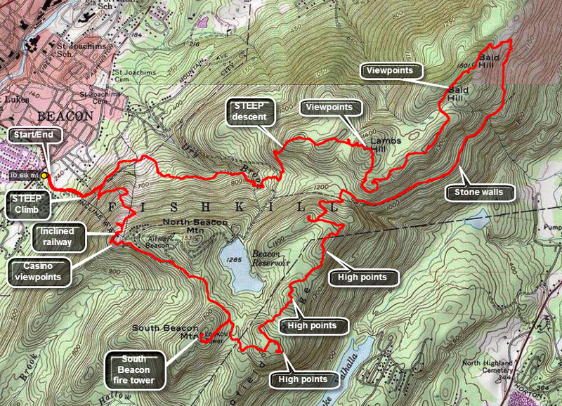 Park at the parking lot for Mount Beacon Park just south of the main center of Beacon on Route 9D. The hike starts on some groomed walkways and heads east on the red Casino Trail and up a series of metal stairs to a woods road at about .5 miles. Along the way look to you right and you will see the remains of the track of the elevated Otis Railway that took patrons to the casino that was perched on the lookouts at the top of the trail. The woods road winds back and forth through several switchbacks to mitigate the steepness of the mountain. The trail is eroded in many places with loose rocks.There are some viewpoints on the way up but the best ones are at the top. At about 1.2 miles you will be near the top of the mountain. Watch for the ruins of a red brick building. This housed the donkey engines which polled the cars of the elevated railway to the top. Some of the machinery is still present. You may be able to find pieces of track and cables. Walk to the viewpoints and imagine what is was like when the casino was in operation. You can inspect the foundations and get some idea of the size of the casino before getting back on the trail and heading southeast to about 2 mile. Turn right here on the white Breakneck Ridge Trail and follow it on a steep ascent to the South Beacon fire tower. The tower has been completely restored and is safe to climb to the cab. The steps, landings and cab floor are all open grid steel which can be a little disconcerting but perfectly safe. The view from the tower is 360 degrees. Retrace your steps to the Casino trail and walk to the junction with the yellow Wilkinson Trail. Turn left to begin to walk along Scofield Ridge The ridge is just over the county line and is the highest point in Putnam County. The trail may not pass over the highest point on the ridge and there is a lot of debate over where that point is located. You may want to bushwhack a little off the trail to find the highest spot and take in some great views. At about 4.5 miles a short side trail leads to a fantastic lookout which is worth the brief walk. The trail takes some sharp turns and descends steeply in spots crossing some other trails, paths and woods roads. At about 5 miles the yellow Wilkinson Trail start to descend off the ridge. Bear left on the white Fishkill Ridge Trail. This trail starts by traveling parallel to the ridge as it slowly rises in to the 6.3 mile point. This walk of about 1.25 miles along the ridge has some possible viewpoints especially near the turn at the end but better things are to come. The trail now turns almost 180 degrees and continues to rises almost to the top of Bald Hill;. The views from here are unobstructed. After this point the trail continues to rise and fall with a few more viewpoints along the way. At 7.8 miles there is another viewpoint and just passed this you will be at Dozer Junction. This trail junction has a large, yellow bulldozer! Continue on the white Fishkill Ridge Trail as it ascends Lambs Hill for some more views. At 8.6 miles there will be another lookout and a junction with the red Overlook Trail. Stay to the left and continue to follow the white trail down the ridge. At around 9 miles you will cross over a road that goes to the Beacon Reservoir. The trail marking can be confusing here so look across the road to pick up the blazes and continue on the trail. For the next .5 miles the trail runs along a stream and there may be some waterfalls on the stream and the small tributaries depending on the volume of water. At 9.5 miles the white trail continues to the right. Bear left on the yellow trail which will return you on a woods road to the top of the stairs which lead back down to the parking lot.
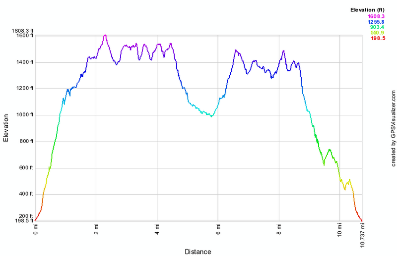
(The image at the left shows the profile of the hike. Remember that all vertical profiles are relative!)
Ninham Fire Tower
| Quick Look | ||||
|---|---|---|---|---|
| Difficulty | Round trip | Total climb | Internet Maps | |
| 1.4 mi. | 385 ft. | AllTrails | ||
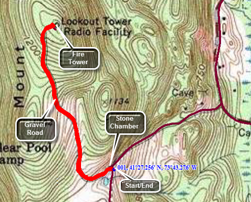
From Carmel, NY head east on Route 301. After crossing over the West Branch Reservoir, turn right on Gypsy Trail Road (Route 41). From the north take Route 301 from the Taconic Parkway and head west on Route 301. Turn left on Gypsy Trail Road just before crossing the reservoir. Drive about 2.3 miles to Mount Ninham Court on the left. DO NOT park at the Ninham Multiple Use parking area on the right at about 2.0 miles. After turning onto Mount Ninham Court, drive to the end and park in the small lot. Two roads leave the parking area. Use the gated road to the right. Before leaving the parking area, observe the stone chamber in the side of the hill. There are several of these in the area and their origin is a mystery. Walk up the road which will take you to the fire tower. There is another chamber on the right. There are many stone walls on the mountain. Many of these wall have stones much larger than the typical stones found in walls. After walking .75 miles and gaining 380 feet, you will be at the tower. It is hard to get a picture of the tower as it is surrounded by trees and communications towers. The tower seems safe to climb and the cab is open but without a roof. When you are done, retrace your steps to the car or explore a little in the area.
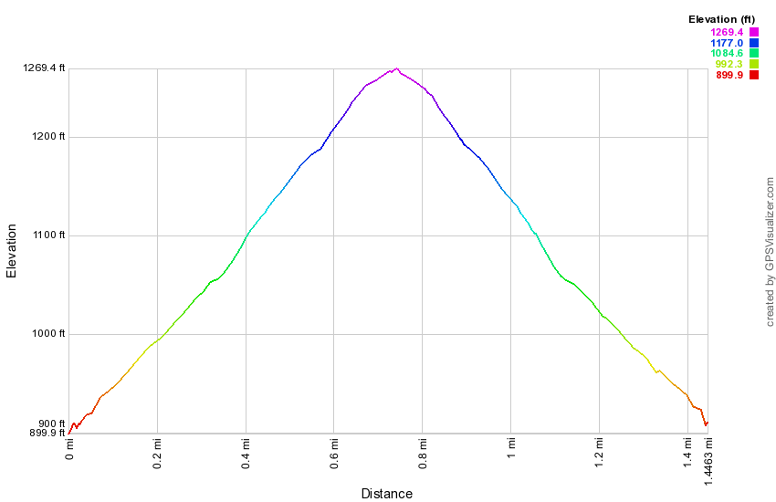
(The image at the left shows the profile of the hike. Remember that all vertical profiles are relative!)
Nuclear Lake to Dover Oak
| Quick Look | ||||
|---|---|---|---|---|
| Difficulty | Round trip | Total climb | Internet Maps | |
| 5.9 mi. | 1420 ft. | AllTrails | ||
This hike is really from Route 20 to Nuclear Lake and back.Take the Taconic State Parkway north off I84 and then take the next exit for Route 52 toward Carmel. At the Stormville Post Office turn left on Route 216 and follow it to Route 55. Turn right on Route 55 and within 1.8 miles turn left on Old Route 55. Follow Old Route 55 to Dodge Road and turn left. Follow Dodge Road to the end and turn left on Route 20 which is locally called West Dover Road. Within one mile you will find the point where the AT crosses the road. On the right side of the road is the Dover Oak which is said to be the largest oak tree on the AT. Cross the road to get on the AT which at first descends to a wet area which is crossed by some puncheons. After this the trail begins a rather steep ascent to a shoulder of West Mountain and a viewpoint called the Cat Rocks. The ascent is .7 miles and you will gain over 600 feet. There are several switchbacks that moderate the climb. Passed the Telephone Pioneers Shelter side trail on the way up. At the top of the climb the trail levels out at the highest point which is around 1250 feet. At .9 miles a side trail on the right leads to an extensive open rock face. This is the Cat Rocks and there is about a 180 degree view to the east. Walk back up to the AT and continued west toward Nuclear Lake for about 2 miles. From the viewpoint the trail drops some elevation to about 1.8 miles where you cross some puncheons across a marshy area at an elevation of almost 1100 feet. Having a marshy area like this at a higher elevation is unusual. Gained some more and then at about 2 miles start to drop toward the lake. Over the next mile you lose about 350 feet on a gentle grade with a few steeper parts and switchbacks mixed in. At almost exactly 3 miles you will come to the loop trail where you may turn around for the return trip or continue for an additional 2 miles around the lake.
(The image at the left shows the profile of the hike. Remember that all vertical profiles are relative!)
Nuclear Lake from Route 20
| Quick Look | ||||
|---|---|---|---|---|
| Difficulty | Round trip | Total climb | Internet Maps | |
| 7.8 mi. | 1700 ft. | AllTrails | ||
Take the Taconic State Parkway north off I84 and then take the next exit for Route 52 toward Carmel. At the Stormville Post Office turn left on Route 216 and follow it to Route 55. Turn right on Route 55 and within 1.8 miles turn left on Old Route 55. Follow Old Route 55 to Dodge Road and turn left. Follow Dodge Road to the end and turn left on Route 20 which is locally called West Dover Road. Within one mile you will find the point where the AT crosses the road. On the right side of the road is the Dover Oak which is said to be the largest oak tree on the AT. Cross the road to get on the AT which at first descends to a wet area which is crossed by some puncheons. After this the trail begins a rather steep ascent to a shoulder of West Mountain and a viewpoint called the Cat Rocks. The ascent is .7 miles and you will gain over 600 feet. There are several switchbacks that moderate the climb. Passed the Telephone Pioneers Shelter side trail on the way up. At the top of the climb the trail levels out at the highest point which is around 1250 feet. At .9 miles a side trail on the right leads to an extensive open rock face. This is the Cat Rocks and there is about a 180 degree view to the east. Walk back up to the AT and continued west toward Nuclear Lake for about 2 miles. From the viewpoint the trail drops some elevation to about 1.8 miles where you cross some puncheons across a marshy area at an elevation of almost 1100 feet. Having a marshy area like this at a higher elevation is unusual. Gained some more and then at about 2 miles start to drop toward the lake. Over the next mile you lose about 350 feet on a gentle grade with a few steeper parts and switchbacks mixed in. At almost exactly 3 miles you will come to the loop trail where you should bear to the left on the loop trail around the lake. The trail stays pretty far away from the water and from the cliffs that line the eastern shore. This trail starts out fairly flat but soon becomes rocky with a few short but steep ascents and descents. At one point a path to the right leads to a very nice lookout with views of the small island and the rest of the lake. Continue on the main trail and you will soon cross the access road to the lake. Re-enter the trees and rejoin the AT at about 4 miles into the hike. Bear right on the AT. It is almost exactly 2 miles around the lake. At 4.3 miles into the hike you will get another look at the lake and be able to walk down to the shore. In the early 1970's there was an explosion at a small research facility on the shores of the lake. This scattered a small amount of radioactive material in the surrounding forest. The material was cleaned up and subsequent testing showed no more radiation than normal background. Shortly after the facility was closed and the building razed. Head back to the AT again and the trail becomes very rocky and descends to very near the shore of the lake. Continue around the lake and at 4.9 miles the AT turns left. Follow the AT 2.9 miles back to the car.
(The image at the left shows the profile of the hike. Remember that all vertical profiles are relative!)
Nuclear Lake from Route 55
| Quick Look | ||||
|---|---|---|---|---|
| Difficulty | Round trip | Total climb | Internet Maps | |
| 4.4 mi. | 620 ft. | AllTrails | ||
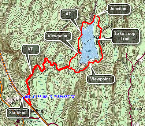
Take the Taconic State Parkway north off I84 and then take the next exit for Route 52 toward Carmel. At the Stormville Post Office turn left on Route 216 and follow it to Route 55. Turn right on Route 55 and within 1.5 miles find an AT parking area on the right side of the road. Walk southeast on Route 55 for about 100 feet to where the AT crosses the road. Turn left into the woods. The distance from Route 55 to Nuclear Lake appears to be about .6 miles but the trail keeps winding this way and that extending the distance to 1.2 miles. You will eventually come to the first junction with the loop trail even though the lake is not in view. The AT so far has been level in most places and rocky in a few others but there has been very little up or down. Stay on the AT along the west side of the lake. At 1.5 miles into the hike you will get a look at the lake and be able to walk down to the shore. In the early 1970's there was an explosion at a small research facility on the shores of the lake. This scattered a small amount of radioactive material in the surrounding forest. The material was cleaned up and subsequent testing showed no more radiation than normal background. Shortly after the facility was closed and the building razed. Head back to the AT again and the trail becomes very rocky and descends to very near the shore of the lake. Continue around the lake and at 2.2 miles the AT turns left. Bear to the right on the loop trail around the lake. The trail stays pretty far away from the water and from the cliffs that line the eastern shore. This trail starts out fairly flat but soon becomes rocky with a few short but steep ascents and descents. At one point a path to the right leads to a very nice lookout with views of the small island and the rest of the lake. Continue on the main trail and you will soon cross the access road to the lake. Re-enter the trees and complete the loop by rejoining the AT at 3.25 miles into the hike. It is almost exactly 2 miles around the lake and you only have the 1.2 mile walk back to the car to go. As you near Route 55 you may take the blue shortcut trail on the right back to the parking area to avoid hiking along the main road.
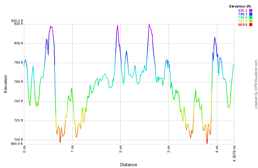
(The image at the left shows the profile of the hike. Remember that all vertical profiles are relative!)
Route 52 to Depot Hill
| Quick Look | ||||
|---|---|---|---|---|
| Difficulty | Round trip | Total climb | Internet Maps | |
| 9.2 mi. | 1690 ft. | AllTrails | ||
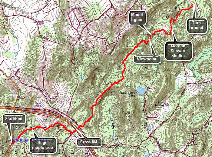
Take the Taconic State Parkway north off I84 and then take the next exit for Route 52. Turn right off the exit and follow it through Stormville and until it passes under I84 again. About .5 miles up a hill there will be an AT parking area in the woods on the left side of the road. Park in the lot and walk back out to Route 52 and follow it about 125 feet south to where the trail crosses the road. Turn left into the woods. The trail climbs a little before leveling off and passes along the edge of an open area. There are some very limited views. Within 15 minutes from the start of the hike re-enter the woods and to find very large maple tree about 20 feet in circumference! Continue hiking and in less than a mile come out onto a side street where the trail follows the road to the right. Continued to follow the blazes and turn left onto Mountain Top Road which takes you over I84. The road comes to a T on the other side. Continue straight ahead on the AT as it enters the woods. Walk down a set of stone steps and across a brook on a bridge. This is at about 1.4 miles into the hike. The trail the surface becomes rockier and where there are fewer rocks there are more roots. The hike is generally a gentle ascent heading for Mount Egbert. At around 3.4 miles there is a viewpoint with limited views especially when the leaves or on the trees. Resume the hike which becomes steeper as you scale Mount Egbert whose summit is at about 3.6 miles. Just after the summit of Egbert begin a descent and you will find a short side trail to the Morgan Stewart Shelter on the right. Continue along the trail on a long descent with a series of ups and downs. Despite the literature there are no more views! At 4.6 miles you will enter a low area with some marshy ground and many insects in the appropriate seasons. You may turn around here or hike to Depot Hill Road at about 5 miles. This road is barely a gravel track where the AT crosses.
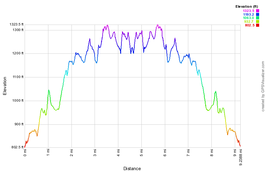
(The image at the left shows the profile of the hike. Remember that all vertical profiles are relative!)
Shenandoah Mountain to Route 52
| Quick Look | ||||
|---|---|---|---|---|
| Difficulty | Round trip | Total climb | Internet Maps | |
| 8.5 mi. | 2322 ft. | AllTrails | ||
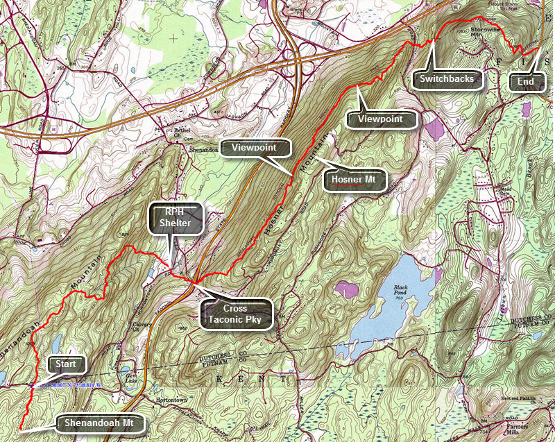 This hike describes a one way hike that requires a pickup at the end because the round trip distance would be over 16 miles.
Take the Taconic State Parkway south off I84 and then take the Miller Hill Road exit. Turn right off the exit and then left on Hortontown Road. Watch for Long Hill Road on the right and drive uphill. The road makes a sharp right and turns into a dirt road. Pass under some powerlines and the parking area will be on the right side of the trail at the apex of the road. If you need to go to the top of Shenandoah Mountain, cross the road and hike on a fairly gentle ascent for about .4 miles. Tag the summit and return to the car to begin the real hike! From the parking area headed north on the AT. From Long Hill Road the trail descends with only a few small ascents along the way. There are no real views on this section. At 1.4 miles cross a power line right-of-way. The trail quickly re-enters the woods still heading downhill but turning more to the northeast. At 2.7 miles the trail starts a steep descent to the lowest point on the hike at 370 feet. Cross a stream and then another on bridges before ascending toward Hortontown Road at 3.25 miles. This area of the trail has several stretches of puncheons used to cross wet ground. Just before crossing the road a nice hiker's cabin is just off the trail to the right. There is a privy on the left side of the trail. Cross the road and the climb for about .25 miles before crossing under the Taconic Parkway on Miller Hill Road. Just after the parkway, turn left on Rock Ledge Road. The trail almost immediately turns right into the woods.
For the next mile or so the trail gains about 500 feet in elevation as it follows along the western shoulder of the Hosner Mountain ridge. A blue trail heads down the mountain at one point. Eventually the trail levels off a little with only a few ups and downs. Just before passing by the summit of Hosner Mountain at 5.4 miles, there is a very nice lookout to the left of the trail looking west and north. There are mountains in the background and farmland below. Several small villages dot the landscape. At 6.3 miles the trail begins to descend and there is another small lookout on the right of the trail to the east and south. For the next .7 miles the trail loses about 460 feet of elevation and travels over some slick rocks. Cross Hosner Mountain Road 7 miles into the hike. Just after the road cross another stream on a bridge and then begin to climb! Over the next .65 miles gain about 450 feet as the trail skirts the summit of Stormville Mountain. There are MANY short switchbacks which cut the steepness of the ascent but became annoying after a while. After a brief descent there is another ascent before the descent to Route 52 where you can wait for your ride.
(The image at the left shows the profile of the hike. Remember that all vertical profiles are relative!)
Stissing Mountain
| Quick Look | ||||
|---|---|---|---|---|
| Difficulty | Round trip | Total climb | Internet Maps | |
| 1.9 mi. | 940 ft. | AllTrails | ||
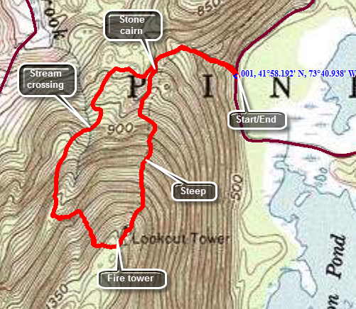
There are several possible access points for Stissing Mountain. It is unclear whether all have an easement over private property. The access from Lake Road is in the Thompson Pond area owned by the Nature Conservancy and featured on their website. Thompson Pond is an "ancient pond" formed as a kettle lake. From Pine Plains, take Route 199 west. Just outside of town turn left on Lake Road. From the west take Route 199 east and turn right on Lake Road just before you enter Pine Plains. Drive about 1.5 miles on Lake road to the FIRST parking area on the left. Directly across the road is a gated woods road that is the access to Stissing Mountain. Walk through the gate and start up the woods road or path net to it. After hiking only .25 miles the road splits. The left branch is steeper but a little shorter. Bear left to ascend to the tower. From the fork in the trail it is only another .5 miles but the elevation gain is 620 feet with an average grade of 23%. Parts of the trail level off some so the steeper parts can be quite steep. The tower affords the only real view from the summit and it seems sturdy enough as you climb. The view from the top is well worth the climb. There are great views to the east over Stissing Pond and Thompson Pond. When you have taken in the view and taken some pictures descend the tower for the trip back. To make a loop, walk passed the tower and take the trail that branches to the left. This is a short, steep descent which can be icy. At the bottom of this descent turn right and head down the trail which parallels the one you ascended. This part can be wet and part way down you will cross a small stream. About .8 miles from the tower you will be back at the stone cairn that marks the fork in the trail. Retrace your path back to the parking area.
(The image at the left shows the profile of the hike. Remember that all vertical profiles are relative!)
White Rocks to Old Albany Post Rd
| Quick Look | ||||
|---|---|---|---|---|
| Difficulty | Round trip | Total climb | Internet Maps | |
| 9.1 mi. | 2245 ft. | AllTrails | ||
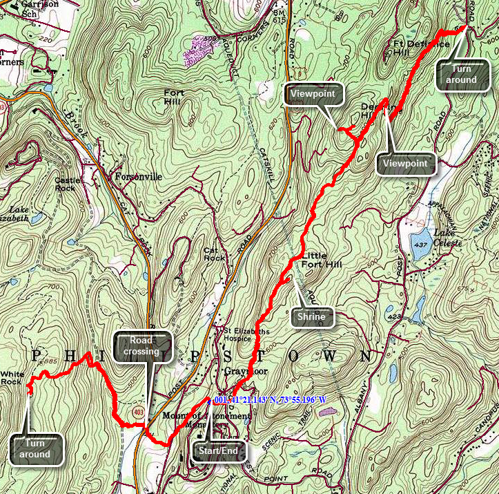 Take Route 9D south from the Newburgh-Beacon bridge to Garrison. Follow Route 403 southeast to Route 9. At Route 9 I turn left and shortly after turn right onto Old West Point Road. A short distance up the road turn right on Graymoor Road. Park on the grassy shoulder of the road where the AT crosses just before the road splits. Graymoor is a Franciscan monastery and retreat. Follow the AT and descend for about .3 miles and then walked another .2 miles to where the trail crosses Route 9 and Route 403. After crossing the roads, there is a sign board or kiosk and then a long elevated walkway across a marshy area. Begin to climb for the next .5 miles to a trail junction on a fairly wide and well-maintained woods road along a small stream. At the trail junction turn left and stay on the AT to the top of the ridge. At 1.4 miles you will top the ridge. Turn left to stay on the AT. Over the next .1 or so miles there will be paths to walk out to the edge of the ridge to various viewpoints. There are places that may have been viewpoints but are now blocked by trees. Turn back and follow your path back to the car. Cross the road and pick up the AT again on the other side. The trail crosses the Old West Point Road and descends to a swampy area before starting to climb again. The trail heads northeast and at 3.9 miles there is a trail to the right that ascends Little Fort Hill. Climb the short trail to find a stone wall which surrounds a small "park". At one end is a small shrine labeled "Virgen Missionera Madre de los Immigrantes"! Turn around to descend the spur trail back to the AT. Turn right on the AT and continue to hike to the northeast. At 4.9 miles another spur trail turns off to the left to ascend Denning Hill. Follow the trail and look for a viewpoint near the end. There is a rock ledge near the end of the trail but, like so many others, the view is now obscured by the trees. Return to the main trail and turned left to continue to the northeast. You will pass by Fort Defiance Hill on your left. At 5.5 miles you will be on top of a ridge where the trail turns sharply to the right and starts down. You will have to drop almost 450 feet to reach the road. As you start down watch for the best viewpoint of the day on an open rock face with an unobstructed view to the south and east. Of course, there isn't much to see except trees! Continue to follow the trail down until it levels off. The trail surface is mostly jagged rocks which makes walking a challenge. Along the way the trail begins to climb along the shoulder of the ridge before the final descent to the road. Continue follow the trail and finally reach the road at 6.3 miles. Turn around and begin the trek back to the car.
(The map above shows the parking area and the hiking route.)
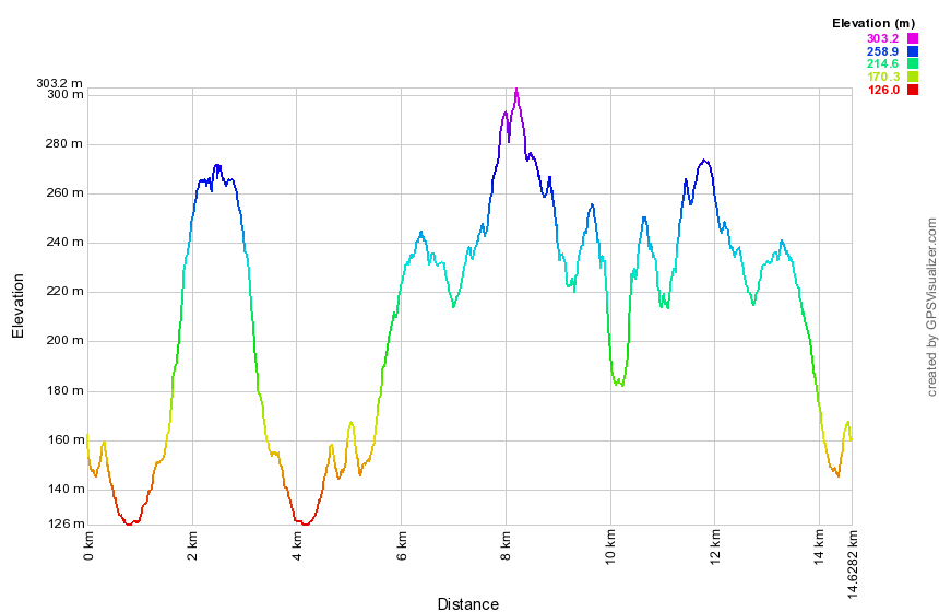
(The image at the left shows the profile of the hike. Remember that all vertical profiles are relative!)