
What You Missed
Winter 2022-2023
Winter 2022-2023
![]()
![]()
![]()
![]()
![]() On Sunday, March 19th, I wanted to get in a hike with Cindy after we returned from church. Cindy likes short, flat hikes so I chose to go to the Beaverkill Campgrounds to hike along the river. The campground is closed for the winter and I thought it would be quiet. I also hoped the recent snow would add some interest to the pictures I might take. We also knew the route would have some packed snow and ice. We started to get ready at 1:00 PM with the temperature at 28 degrees. Sheila certainly was happy to go hiking anywhere at any time. I put on my Patagonia 1/4-zip woo; top with a lighter, long-sleeved baselayer. I wore a pair of Bauer First Ascent pants which are insulated against the cold and are slightly water repellant. I don't like the fit of these pants and have been looking for a replacement. I wore my Solomon B-52 winter hiking boots as I did not know how much snow and ice to expect. These boots are old and beginning to show some wear but I replaced the insoles with a pair of Protalus insoles to provide arch support. I took my Leki poles with external locks as the internal twist locks sometimes fail. I wore a fleecy orange hat, packed a pair of gloves, and put on my OR Crocodile gaiters because of the possibility of water and mud. I also donned my Mammut hoody which has enough zippers to dump heat when it is needed. We left the house at 1:15 PM as I drove out Old Route 17 toward Roscoe and turned right on Beaverkill Road. As we started the descent into the Beaverkill Valley, I turned left on Campsite Road and followed it down to the parking area near the Beaverkill Covered Bridge. There were no cars parked in the lot. A glance at the river showed that the level was high enough to be interesting. Several inches of snow were on the ground making a pretty scene but there was not enough to make snow shoes necessary. Cindy wanted to put her spikes on immediately but I suggested she wait until it was necessary. As we were getting ready, a white dog appeared and I grabbed Sheila. The dog approached and I yelled at him to go away. His owner appeared shortly and did not say a word about letting her dog run without a leash! She did say she would walk on the near side of the river while we were going to the far side. I put Sheila on her leash and shouldered my pack as we began our hike.
On Sunday, March 19th, I wanted to get in a hike with Cindy after we returned from church. Cindy likes short, flat hikes so I chose to go to the Beaverkill Campgrounds to hike along the river. The campground is closed for the winter and I thought it would be quiet. I also hoped the recent snow would add some interest to the pictures I might take. We also knew the route would have some packed snow and ice. We started to get ready at 1:00 PM with the temperature at 28 degrees. Sheila certainly was happy to go hiking anywhere at any time. I put on my Patagonia 1/4-zip woo; top with a lighter, long-sleeved baselayer. I wore a pair of Bauer First Ascent pants which are insulated against the cold and are slightly water repellant. I don't like the fit of these pants and have been looking for a replacement. I wore my Solomon B-52 winter hiking boots as I did not know how much snow and ice to expect. These boots are old and beginning to show some wear but I replaced the insoles with a pair of Protalus insoles to provide arch support. I took my Leki poles with external locks as the internal twist locks sometimes fail. I wore a fleecy orange hat, packed a pair of gloves, and put on my OR Crocodile gaiters because of the possibility of water and mud. I also donned my Mammut hoody which has enough zippers to dump heat when it is needed. We left the house at 1:15 PM as I drove out Old Route 17 toward Roscoe and turned right on Beaverkill Road. As we started the descent into the Beaverkill Valley, I turned left on Campsite Road and followed it down to the parking area near the Beaverkill Covered Bridge. There were no cars parked in the lot. A glance at the river showed that the level was high enough to be interesting. Several inches of snow were on the ground making a pretty scene but there was not enough to make snow shoes necessary. Cindy wanted to put her spikes on immediately but I suggested she wait until it was necessary. As we were getting ready, a white dog appeared and I grabbed Sheila. The dog approached and I yelled at him to go away. His owner appeared shortly and did not say a word about letting her dog run without a leash! She did say she would walk on the near side of the river while we were going to the far side. I put Sheila on her leash and shouldered my pack as we began our hike.
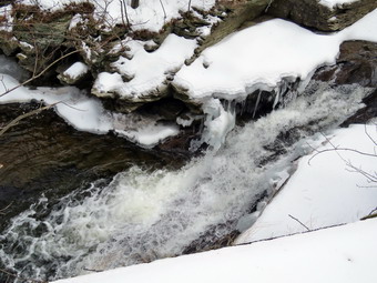
 We started out at 1:30 PM by walking out of the parking lot to the bridge with the temperature at 28 degrees and a stiff breeze blowing. The skies were overcast with a little blue but no bright sunlight. I hoped this would make taking pictures easier. When we got to the other side, the gate just off the road was closed as the campgrounds had closed September 5. I looked at the trail and saw that it had some packed snow and ice but there were also some spots that were clear. We turned left on a woods road that parallels the river and started down a short hill. We were able to work our way around the ice and packed snow. We passed the spring house and continued on the deserted woods road. We came to an area with a little path down to the river. I looked ahead and saw that the road through the campsite had been plowed! I found this interesting as the campsites along this path are no longer used and are abandoned. I walked down to the edge of the river very carefully as the rocks were slippery and the water looked deep and cold. I took some pictures downstream and some upstream to the bridge. The view of the bridge was almost blocked from the angle I had. When I was done photographing, we got back on the trail and passed several areas with unused picnic tables covered in snow. Several picnic tables sat unused and rotting along the road, a testimony to better days. We walked by these tables which had not been used in many years. A little later we came to what was once a bathroom for some campsites that had long since disappeared. Further along on the road, there was another area with more picnic tables. There was a path over to the river so I walked over and found the water was sparkling in what sunlight there was. I took some pictures upstream where the river comes back together from a split. I also took some shots downstream from the retaining wall.
 Cindy had walked farther up the road and I walked faster to catch up to her. We continued on and at about .7 miles the woods road met the paved road that serves the campsites. This area was very icy and we had to pick our way carefully to avoid falling. We continued on the road through the campsites and along the river. These roads were clear to the pavement and seemed just a little longer than usual. The campsites completely empty and I took pictures of the solitude. The road through the campsite was plowed and there was still snow covering the ground. We walked to the last campsite where the road ends and Sheila and I walked down to the edge of the river. I was careful to watch where I was walking as the water was a little high and looked cold. Sheila also avoided the cold clear water. I stopped to take some pictures of the river especially downstream. We continued along the shore a little further passed the last campsite and I took some more shots before walking up to the campsite and back to where Cindy was standing. I stowed my camera and picked up the pack. We walked back from the last campsite, staying to the left of the last bathroom to walk back on the other paved road through the campsites. This road parallels the one we walked out on to make a sort of loop. I decided I did not need any more picture so we retuned the way we had come although at a quicker pace. As we approached the bridge, I looked up to see a couple walking toward us. I grabbed Sheila and walked off to the side of the trail to let the two people pass. We offered each other a brief greeting and then continued on our way. I saw that there was only one car in the lot. We walked through the bridge and turned right to go back to the car. Cindy got in the car but Sheila and I walked down to the stream. The water was high and I had to walk downstream a little to get to the big rock that juts out into the stream. I was able to take some pictures downstream. I turned around and took multiple picture of the bridge and the abutments. I walked back to the car at 2:45 PM having hiked 2.5 miles in 1 hour and 30 minutes. The car's thermometer show the temperature had dropped to 26 degrees. I suggested we drive to Tompkins Falls and Barkaboom Falls but Cindy said "No" so I drove back to the house
![]()
![]()
![]()
![]() On Thursday, March 16th I planned to get out for a hike while there was still some shoe left from the storm earlier in the week. I had planned to get an early start while the snow was still frozen but several early morning ambulance calls put my start off until nearer to noon. When I checked the thermometer at 10:30 AM it was 35 degrees. I decided to go across the street and get in a short hike on Round Top before track practice. Sheila was ready to go as she really likes to hike and we had not been out for a few days. She was keeping a careful eye on me as I dressed. I got dressed in my Mammut crew top with a long-sleeved baselayer. I wore a pair of Bauer First Ascent pants which are insulated against the cold and are slightly water repellant. I don't like the fit of these pants and have been looking for a replacement. I wore my Solomon B-52 winter hiking boots as I did not know how much snow and ice to expect. These boots are old and beginning to show some wear but I replaced the insoles with a pair of Protalus insoles to provide arch support. I almost always take my Leki poles with external locks as the internal twist locks sometimes fail. I put on a warm fleecy hat and a pair of lightweight gloves. I did don my Mammut hoody as it has enough zippers to dump heat if needed. I put on my OR Crocodile gaiters to keep my lower legs warm and to resist the snow that I might kick up. I decided to wear my Tubbs Flex VRT which have the Boa binding. This system uses a thin steel cable system and a ratchet wheel which tightens it to give a custom fit and a secure binding. These snowshoes also have a televator to elevate the hiker's heel on ascents. This is a feature that you didn't know you needed until you try it and then it is hard to live without it! At 11:00 AM we walked out the door to start the hike. I grabbed Sheila's leash from the car and put it on her as we walked up the driveway. I aimed to hike for about an hour but knew I might not get as far as I normally do because of the snow. Sheila was happy to get out as we headed down the driveway and across the street with me trying to stay on the snow covered surfaces. We crossed the street and climbed the snow bank on the ether side of the road to walk across the field to the back of the church. There was defiantly enough snow to warrant the snowshoes. We walked to the back of the church and began the ascent of the steepest hill behind the church. The hill is short but gets the circulation pumping and is the steepest and longest climb on the "trail." I was disappointed that there were only a few inches of snow on the road but I stayed on the grass to avoid dulling the snowshoes. At the top of the hill we paused for a minute so I could look around at the hills that surround the hamlet of Livingston Manor. The skies were cloudy with some blue patches and some sun with a few white clouds. There was snow on the headstones in the cemetery and more on the surrounding hills. I had decided not to bring my pack just to carry my camera. I was a little sorry I did not have the camera as there were some good photographic opportunities. We started on the trail by turning left at the trailhead. There was still a good amount of snow in the woods and on the trail. There were tracks from other people but as far as I could tell none had worn snowshoes.
On Thursday, March 16th I planned to get out for a hike while there was still some shoe left from the storm earlier in the week. I had planned to get an early start while the snow was still frozen but several early morning ambulance calls put my start off until nearer to noon. When I checked the thermometer at 10:30 AM it was 35 degrees. I decided to go across the street and get in a short hike on Round Top before track practice. Sheila was ready to go as she really likes to hike and we had not been out for a few days. She was keeping a careful eye on me as I dressed. I got dressed in my Mammut crew top with a long-sleeved baselayer. I wore a pair of Bauer First Ascent pants which are insulated against the cold and are slightly water repellant. I don't like the fit of these pants and have been looking for a replacement. I wore my Solomon B-52 winter hiking boots as I did not know how much snow and ice to expect. These boots are old and beginning to show some wear but I replaced the insoles with a pair of Protalus insoles to provide arch support. I almost always take my Leki poles with external locks as the internal twist locks sometimes fail. I put on a warm fleecy hat and a pair of lightweight gloves. I did don my Mammut hoody as it has enough zippers to dump heat if needed. I put on my OR Crocodile gaiters to keep my lower legs warm and to resist the snow that I might kick up. I decided to wear my Tubbs Flex VRT which have the Boa binding. This system uses a thin steel cable system and a ratchet wheel which tightens it to give a custom fit and a secure binding. These snowshoes also have a televator to elevate the hiker's heel on ascents. This is a feature that you didn't know you needed until you try it and then it is hard to live without it! At 11:00 AM we walked out the door to start the hike. I grabbed Sheila's leash from the car and put it on her as we walked up the driveway. I aimed to hike for about an hour but knew I might not get as far as I normally do because of the snow. Sheila was happy to get out as we headed down the driveway and across the street with me trying to stay on the snow covered surfaces. We crossed the street and climbed the snow bank on the ether side of the road to walk across the field to the back of the church. There was defiantly enough snow to warrant the snowshoes. We walked to the back of the church and began the ascent of the steepest hill behind the church. The hill is short but gets the circulation pumping and is the steepest and longest climb on the "trail." I was disappointed that there were only a few inches of snow on the road but I stayed on the grass to avoid dulling the snowshoes. At the top of the hill we paused for a minute so I could look around at the hills that surround the hamlet of Livingston Manor. The skies were cloudy with some blue patches and some sun with a few white clouds. There was snow on the headstones in the cemetery and more on the surrounding hills. I had decided not to bring my pack just to carry my camera. I was a little sorry I did not have the camera as there were some good photographic opportunities. We started on the trail by turning left at the trailhead. There was still a good amount of snow in the woods and on the trail. There were tracks from other people but as far as I could tell none had worn snowshoes.
At the first trail junction, I followed Sheila as she turned right and started up the woods road which has the gentler approach of the two. There were a few branches on the trail from the winds that had passed through the area. I removed these branches either by dragging them off the trail or by using my poles on the smaller ones. I continued to be careful to make a nice track although the forecast for rain and ice the following day was discouraging. On the trail the snow depth was from 6 to 8 inches. We reached the end of the woods road and turned left up the hill on the trail. We continued up the trail to the first trail junction with the upper blue trail and turned left to follow the yellow trail along the base of Round Top. The yellow trail was covered in about 6 to 8 inches of snow. There were only a few new branches here and there on the trail. I stopped to remove the branches or used my poles to flick the smaller ones aside. I was getting warmer as we hiked but I was not ready to open any zippers on my hoody. At the next junction with the blue trail we turned right and headed up the blue trail toward the summit. Climbing with the snowshoes proved to be much easier than I thought it might be! I was surprised that as soon as we started up the hill the snow depth increased to 10 to 12 inches with deeper drifts! When we got to the switchback, we turned right and followed it until it came back to the main blue trail. The fact that the switchback sidehills in places made the walk a little more difficult. We turned right and then continued straight ahead and up the hill toward the summit of Round Top bypassing the white crossover trail. As we walked over the high point, the snow continued to be deeper until we started down the other side. We continued over the summit and down the blue trail toward the junction with the yellow trail. I was able to get a glide downhill on the snowshoes as it did not seem that anyone else had been over the summit. We bypassed the white crossover trail again and continued down to the yellow trail. At the junction with the yellow trail we turned right and walked the yellow trail along the base of Round Top to the next junction with the blue trail. We turned left and started slightly downhill toward the lookout over town. The snow continued to be 8 to 10 inches deep with much deeper drifts.
We followed the trail downhill to the lookout. Again, I regretted leaving my camera home as there were some pretty views down to town and the school. There were also some nice views of the hills around town. We followed the yellow trail as it turned left and descended the steep hill back to the first trail junction. There was enough snow to get a glide with the snowshoes and the descent went quickly. When we got to the first trail junction, I checked my watch and it was 10:50 AM. It had taken much longer than usual to hike one figure 8 and I was feeling tired. This was the first time I had used the snowshoes in 2023 and my groin and hips were feeling it! I decided to take advantage of the trench I had made and turned around to start another loop. Sheila seemed please as she dashed ahead of me up the hill. For me, the ascent was definitely more difficult than the descent! At the top of the hill we followed the trail as it turned right and headed uphill toward the junction with the blue trail. Walking in the trench I had made was easier than making the trench and the hike was going quickly. We hiked up a short but snowy hill and arrived at the trail junction. We turned right to follow the trail along the base of Round Top. Shiela was some distance ahead when she came roaring back at me at full speed. She passed me, made a 180 degree turn, and came running back. She repeated this several times before I called her off. At the next junction with the blue trail we turned left and walked the blue trail toward the summit. I debated taking the white crossover tail but continued passed it toward the top. We crossed over the summit and started down the other side. We turned left on the switchback and followed it out into the forest and then back to the main trail. We turned left and walked downhill to the yellow trail where a left turn again took us along the base of Round Top. At the junction, we turned right and walked down the trail to the woods road. We followed the woods road downhill with the ledges to the right. At the first trail junction, we turned left and walked straight out to the trailhead. We turned right and walked downhill crossing the road through the church parking lot. We walked through the field so that I could keep my snowshoes on. We waited to cross the road as several cars went by and then crossed to the driveway to the house. It was 12:45 PM and we had hiked a little over 2 miles in a an hour and 45 minutes. My legs were now pretty sore but I was glad we got to hike.
![]()
![]()
![]()
![]()
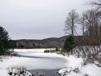
![]() On Friday, March 10th, I wanted to get out and do a longer hike after a slew of ambulance calls during the week. I decided that I wanted to go to Alder Lake to hike to the Beaver Meadow Lean-to which would be better named the Beaver Pond lean-to as the beavers have returned. They have built an impressive dam and there are at least two lodges. I knew I could extend the hike by going to the Millbrook Ridge high point or visiting the falls on Alder Creek below the lake. I started to get ready at 11:15 AM when the temperature was 40 degrees. The skies were mostly overcast with some sun and blue in the skies. Sheila was hovering around me as she can always detect when I am getting ready for a hike. I put on my Mammut crew top with a long-sleeved baselayer. I wore a pair of Bauer First Ascent pants which are insulated against the cold and are slightly water repellant. I don't like the fit of these pants and have been looking for a replacement. I wore my Solomon B-52 winter hiking boots as I did not know how much snow and ice to expect. These boots are old and beginning to show some wear but I replaced the insoles with a pair of Protalus insoles to provide arch support. I almost always take my Leki poles with external locks as the internal twist locks sometimes fail. I put on a warm fleecy hat and a pair of lightweight gloves. I packed a pair of heavier gloves in case they were needed. I did don my Mammut hoody as it has enough zippers to dump heat if needed. I put on my OR Crocodile gaiters to keep my lower legs warm and to resist the snow and water that I might kick up. I put on a light hat and a light pair of gloves. I also packed a heavier pair of gloves in case they were needed. I made sure my spikes were in my pack in case they were needed. I got my gear and Sheila in my car and left Livingston Manor at 11:30 AM and drove north and west on Old Route 17 toward Roscoe. Just outside of town I turned right on the Beaverkill Road and headed north. As I passed Waneta Lake, I noticed a car parked on the side of the road. There were tow men out on the ice with tip-ups! The water was open near shore and there was no ice near the outlet dam. I thought there might be an ice rescue by the time I returned from the hike. I continued on the Beaverkill Road through Lew Beach and Turnwood toward Alder Creek Road where I made a left. I continued to the end on the road where I turned right toward Alder Lake. The DEC has not been consistent in plowing the parking areas at trailheads this season so I thought I might have to walk the access road. I was happily surprised when I saw the gate was open and the access road was in good shape. I drove up the access road very slowly as there are some very rough spots. When I got to the parking area there was one car parked the wrong way near the trailhead. I parked by pulling in and started to get ready to hike. Several young people walked up from the lake, got into the car, and drove away. I set my GPS and we started out on the path toward the "lawn" at 12:00 PM with the temperature at 37 degrees.
On Friday, March 10th, I wanted to get out and do a longer hike after a slew of ambulance calls during the week. I decided that I wanted to go to Alder Lake to hike to the Beaver Meadow Lean-to which would be better named the Beaver Pond lean-to as the beavers have returned. They have built an impressive dam and there are at least two lodges. I knew I could extend the hike by going to the Millbrook Ridge high point or visiting the falls on Alder Creek below the lake. I started to get ready at 11:15 AM when the temperature was 40 degrees. The skies were mostly overcast with some sun and blue in the skies. Sheila was hovering around me as she can always detect when I am getting ready for a hike. I put on my Mammut crew top with a long-sleeved baselayer. I wore a pair of Bauer First Ascent pants which are insulated against the cold and are slightly water repellant. I don't like the fit of these pants and have been looking for a replacement. I wore my Solomon B-52 winter hiking boots as I did not know how much snow and ice to expect. These boots are old and beginning to show some wear but I replaced the insoles with a pair of Protalus insoles to provide arch support. I almost always take my Leki poles with external locks as the internal twist locks sometimes fail. I put on a warm fleecy hat and a pair of lightweight gloves. I packed a pair of heavier gloves in case they were needed. I did don my Mammut hoody as it has enough zippers to dump heat if needed. I put on my OR Crocodile gaiters to keep my lower legs warm and to resist the snow and water that I might kick up. I put on a light hat and a light pair of gloves. I also packed a heavier pair of gloves in case they were needed. I made sure my spikes were in my pack in case they were needed. I got my gear and Sheila in my car and left Livingston Manor at 11:30 AM and drove north and west on Old Route 17 toward Roscoe. Just outside of town I turned right on the Beaverkill Road and headed north. As I passed Waneta Lake, I noticed a car parked on the side of the road. There were tow men out on the ice with tip-ups! The water was open near shore and there was no ice near the outlet dam. I thought there might be an ice rescue by the time I returned from the hike. I continued on the Beaverkill Road through Lew Beach and Turnwood toward Alder Creek Road where I made a left. I continued to the end on the road where I turned right toward Alder Lake. The DEC has not been consistent in plowing the parking areas at trailheads this season so I thought I might have to walk the access road. I was happily surprised when I saw the gate was open and the access road was in good shape. I drove up the access road very slowly as there are some very rough spots. When I got to the parking area there was one car parked the wrong way near the trailhead. I parked by pulling in and started to get ready to hike. Several young people walked up from the lake, got into the car, and drove away. I set my GPS and we started out on the path toward the "lawn" at 12:00 PM with the temperature at 37 degrees.
 We walked along the path which passes by the stone foundations which marks the last remnants of the Coykendall Mansion. The house had been built as a large hunting lodge and then was gifted to the Boy Scouts of America. When the state took over the property, the mansion fell into disrepair with campers tearing boards away to use for campfires. The state added a fence but it did not deter people so the house was eventually burned to the ground. I decided I wanted to walk directly to the beaver pond and Lena-to without stopping to take pictures. We walked down the left side of the lawn where there were areas that had no snow and others where there was at most 2 inches. I could see at least two sets of snowshoe prints and the faint outline of cross country skis. We started walking east along the trail on the north side of the lake. The trail was a little damp with a few muddy spots but there was a total lack of snow. The brush and branches that had overgrown the trail were now dead and the walking was much easier\. This reminded me that I should call my maintainer for this trail to see if he intended to work on the trail. The small streams that cross the trail had some water in them. Sheila was happy to be out and ran ahead and then returned to me. As we continued, a layer of snow developed on the trail but was only 2 inches deep. We approached the bridges and I noticed the skies were now a little more blue and the sun was shining through the clouds. We continued on the trail and we crossed the bridges on the trail near the head end of the lake. I could see the beaver dam that impounded some water from the inlet streams was still mostly intact. One of the bridges had several broken boards on the side and I wished that the DEC would take more interest in maintaining this well-used camping spot. We continued on the trail toward the junction with the Millbrook Ridge Trail. At the point where a path leads to the left to some primitive campsite, some large trees had fallen across the trail. We were able to step over them but it was not easy. I made a note to call the local ranger to see if we could schedule a time to remove them with a chainsaw. At the trail junction, we turned left to head toward the lean-to on the Millbrook Ridge Trail. I was happy that almost all the tracks went left also as they made a nice packed trail. There continued to be only a few inches of snow and even off the trail it was quite solid. Fortunately, the trail showed more use than I had expected and was relatively clear of branches. There were more large trees down across the trail than I remembered. While all the blowdowns could be crossed or walked around, I still wanted to make a push to get them all cleared this summer. We crossed some streams that were almost dry the last time I had visited but were now flowing nicely. Alder Creek had quite a bit of water and we could hear it as it ran downstream over the rocks. The trail is pretty obvious and the blazes easy to see in most places. For the next 1.5 miles the trail climbed and then leveled off several times. The elevation gain is several hundred feet but the grade is never more than 12% and averages around 6%. There isn't too much to see along the way but this day was very pleasant because of the temperature and my mood.
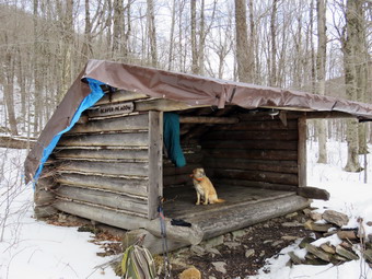
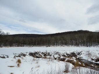 The trail levels off at the first beaver meadow and cross a small stream that feeds it. Sheila took the time to get a drink. I was so happy to be out that I completely missed that we had walked past the first beaver meadow! At 2.2 miles we began the last climb and I found that the going was easier than I thought it would be. I stopped to open some zippers as I was getting very warm. As we started the climb, we came across a few more blowdowns. Soon we arrived at the beaver pond. Where there had once been a beaver meadow, there was now a pond with a dam and a beaver lodge. The pond was larger than the last time I had visited occupying the entire meadow. As I looked around I was overcome by the feeling of joy at seeing what God has created! I realized that the return trip would be much easier as it was almost all downhill. We walked over to the lean-to and found the heavy-duty tarp that had been attached to the roof was still in place. The lean-to has been largely ignored while others are repaired or entirely reconstructed. This is a popular spot but it is not near a 3500 foot peak. The local ranger told me that this lean-to was scheduled for work the previous fall but absolutely nothing had been done. I hope that the tarp on the roof is not the total extent of that work. I was not even sure the DEC had placed the tarp or whether it had been added by some hikers. A large tree had fallen down in front of the lean-to blocking the view of the pond. I took a few pictures of the lean-to and the tree and then decided to walk out to the shore of the pond. The skies were now more overcast and there was a breeze. I took pictures of the lean-to and the tree in front. I also took shots of the pond and the hills around it and few of the dam and beaver lodge. After I got a drink, I decided not to head to the Millbrrok Ridge high point as it was getting late. We walked out to the main trail and turned left. As we came to the spot on the trail opposite the beaver dam, we walked off the trail to the left and found a good viewpoint. I took pictures of the pond and the dam. I also took some shots of the beaver lodge with the lean-to in the background. When I was done, we returned to the main trail, turned left, and headed back to the parking area. I was hoping to set a blazing pace on the way back. The walk did go quickly and we were soon at the loop trail around Alder Lake where we turned right to return the way we came.
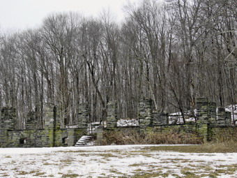 We crossed the bridges an found an open view of Cradle Rock Ridge but the skies were now overcast. We continued on the trail toward the parking area over the thin covering of snow which was now a little softer. When the trail met the "lawn" we turned left and walked to the shore. I put my pack down and retrieved my camera. Even though it was overcast, I took pictures of the lake and all the surrounding hills from Millbrook Ridge on the north to Cradle Rock Ridge on the south. After I finished, I packed up and we walked up the hill toward the ruins of the lodge. I was struck by the stark stone against the bleak landscape. I took a few shots before we headed toward the parking area. As we approached the parking area, I noted that it had taken 65 minutes to walk out the trail and 60 minutes to come back. So much for a quicker pace on the return trip! I chalked this up to the fact that it was difficult to make any speed going downhill with the slippery snow. We were back at the car at 2:25 PM after hiking 4.6 miles in 2 hours and 25 minutes with 10 minutes of stopped time. The elevation gain was 640 feet. Our moving speed was 2 MPH despite the conditions. On the way back home I thought about the fishermen on the ice and how they had fared. As I passed Waneta Lake, the two men were still out on the ice!
![]()
![]()
![]()
![]()
![]() On Wednesday, March 8th I wanted to get out for a hike as it relaxes me and keeps me blood pressure in check. Lisa contacted me asking if I wanted to hike and I said 'Yes'. The question was when and where. The wind had been whipping a round and the predicted wind-chill for Wednesday was in the single digits! Lisa asked to go to Hodge Pond and I said I was willing if the forecast did not pan out. When I got up at 8:00 AM the temperature was 24 degrees and the wind was still blowing. I talked to Lisa and told her I did not want to keep Sheila out too long in those temperatures. We agreed to hike the Parksville Rail Trail from Fox Mountain Road to Parksville and back. The hike is about 2.5 miles but I was hoping the falls would be flowing as they are beautiful. Lisa was going to come to my house at 10:30 AM so we could take one car to the trailhead. I started to get ready at 10:00 AM with the temperature at 28 degrees and a breeze blowing! Sheila could not contain her excitement as we were getting dressed as if she thought we might not hike again! The skies were blue but overcast. I knew that the trail could be icy but would be covered with patches of snow from the last storm. I made sure my spikes were in my pack in case they were needed. I put on my Patagonia long-sleeved wool 1/4 zip top with a long-sleeved baselayer. I wore a pair of Bauer First Ascent pants which are insulated against the cold and are slightly water repellant. I don't like the fit of these pants and have been looking for a replacement. I wore my Solomon B-52 winter hiking boots as I did not know how much snow and ice to expect. These boots are old and beginning to show some wear but I replaced the insoles with a pair of Protalus insoles to provide arch support. I almost always take my Leki poles with external locks as the internal twist locks sometimes fail. I put on a warm fleecy hat and a pair of lightweight gloves. I packed a pair of heavier gloves in case they were needed. I did don my Mammut hoody as it has enough zippers to dump heat if needed. I put on my OR Crocodile gaiters to keep my lower legs warm and to resist the snow and water that I might kick up. At 10:30 AM I put my gear in the car and Sheila in the back seat as Lisa pulled into my driveway. We put her poles in the car and headed out Old Route 17 and drove across the Flats. I took Old Route 17 and Service Road to the point where they meet Fox Mountain Road. There were no vehicles in the parking lot which was plowed but had a ridge of frozen snow across the entrance. I do not understand why the plow operators can't be a little more careful!
On Wednesday, March 8th I wanted to get out for a hike as it relaxes me and keeps me blood pressure in check. Lisa contacted me asking if I wanted to hike and I said 'Yes'. The question was when and where. The wind had been whipping a round and the predicted wind-chill for Wednesday was in the single digits! Lisa asked to go to Hodge Pond and I said I was willing if the forecast did not pan out. When I got up at 8:00 AM the temperature was 24 degrees and the wind was still blowing. I talked to Lisa and told her I did not want to keep Sheila out too long in those temperatures. We agreed to hike the Parksville Rail Trail from Fox Mountain Road to Parksville and back. The hike is about 2.5 miles but I was hoping the falls would be flowing as they are beautiful. Lisa was going to come to my house at 10:30 AM so we could take one car to the trailhead. I started to get ready at 10:00 AM with the temperature at 28 degrees and a breeze blowing! Sheila could not contain her excitement as we were getting dressed as if she thought we might not hike again! The skies were blue but overcast. I knew that the trail could be icy but would be covered with patches of snow from the last storm. I made sure my spikes were in my pack in case they were needed. I put on my Patagonia long-sleeved wool 1/4 zip top with a long-sleeved baselayer. I wore a pair of Bauer First Ascent pants which are insulated against the cold and are slightly water repellant. I don't like the fit of these pants and have been looking for a replacement. I wore my Solomon B-52 winter hiking boots as I did not know how much snow and ice to expect. These boots are old and beginning to show some wear but I replaced the insoles with a pair of Protalus insoles to provide arch support. I almost always take my Leki poles with external locks as the internal twist locks sometimes fail. I put on a warm fleecy hat and a pair of lightweight gloves. I packed a pair of heavier gloves in case they were needed. I did don my Mammut hoody as it has enough zippers to dump heat if needed. I put on my OR Crocodile gaiters to keep my lower legs warm and to resist the snow and water that I might kick up. At 10:30 AM I put my gear in the car and Sheila in the back seat as Lisa pulled into my driveway. We put her poles in the car and headed out Old Route 17 and drove across the Flats. I took Old Route 17 and Service Road to the point where they meet Fox Mountain Road. There were no vehicles in the parking lot which was plowed but had a ridge of frozen snow across the entrance. I do not understand why the plow operators can't be a little more careful!
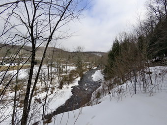
 Lisa decided to put on her spikes at the car while I decided to wait until they were needed. We started out on the trail at 10:45 AM with the temperature at 28 degrees under slighty overcast skies. The open trail just before the woods alternated between open dirt and patches of snow. There were many sets of footprints heading out on trail. Fortunately, there wasn't much snow and the rough surface was manageable giving us some traction so the spikes were not needed. We entered the trees which blocked the breeze but shaded the trail. I was warm enough but we set a quick pace as there are no ills.There was more snow under the trees and it had been chopped up by hikers. The snow had frozen making walking difficult as my feet kept finding their way into boot prints. Areas of ice began in earnest almost immediately but most were covered with a layer of crusty snow allowing some traction. Lisa was able to walk on top of the frozen snow but I kept falling through. We found a medium-sized trunk across the trail. The tree looked like I could cut it with a hand saw and ax to get it off the trail. One look down to the Little Beaverkill showed the stream volume was reasonably high. I wondered about the condition of the falls and whether they would be frozen or not. Sheila was taking her own route and following her nose and getting very close to the edge of the trail where a steep drop led down to the river! We were soon at the wooden walkways and I decided the views were much like our previous hikes. I decided to take a few pictures anyway before continuing over the wooden walkways and bridges. The walkway's wooden surface was covered in a thick layer of ice making the footing slippery but, again, the crusty snow offered some traction. The ice problem comes from a rock slide that has blocked the culvert under the small bridge causing water, mud and stones to be diverted over the walkway. Unblocking the culvert and covering the walkways with some screening would help. This time it was a lot of water that had frozen on the bridge, the walkways, and the trail. We continued on the trail and found a few blowdowns that should be cleared. As we approached the falls, we could hear the sound of the falls roaring.
 When we arrived at the falls, we found that there was a good flow of water with some ice below, at, and above the falls. There was less ice than on our previous visit but it was still pretty. I decided not to put on my spikes and descend to the stream bed. The path looked frozen solid and I knew Sheila would follow me. I did take pictures of the falls ROM overhead. I also snapped some shots upstream and downstream. Before packing up, I took some pictures of the snow on the trail. Lisa and I had been catching up as I don't get to see her much since she moved her store to Hurleyville. We decided to continue the hike on the trail but walked by the bench where a path leads down to the stream. This area was not that interesting and I just wanted to walk. The trail continued to be covered in ice and snow. I was not having any problem with traction even though I was not wearing spikes. Lisa had her spikes on and was marching along with a sure grip. We set a quick pace for the rest of the hike toward the Parksville end of the trail. Just after the gate at that end, we stopped and turned around to head back to the car. I was hoping I had not missed any ambulance calls as there usually aren't other EMTs to cover calls during the day. We looked at the sign which outlines the milk that the O&W transported. The sign also mentions the large number of hotels that had been in the area. I knew I would not be taking any pictures and we set a rapid return pace. We were back at the car at 12:15 PM after hiking 2.6 miles in 1 hour and 30 minutes. There is virtually no elevation gain on the hike.
![]()
![]()
![]()
![]()
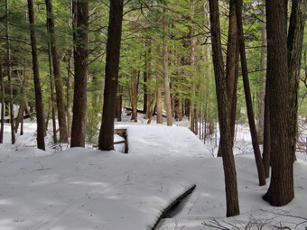
![]() On Monday, March 6th I wanted to get in a hike somewhere away from Livingston Manor. But not too far. I asked Cindy if she would like to hike to Frick Pond and do the Loggers Loop I started to get ready at 11:45 AM with the temperature at 37 degrees on the back porch. We knew that the trail could have some snow covering with ice but suspected there also might be some open water and mud. I put on my Mammut long-sleeved crew top with a long sleeved baselayer. I wore a pair of Bauer First Ascent pants which are insulated against the cold and are slightly water repellant. I don't like the fit of these pants and have been looking for a replacement. I decided to put on my Keen Durand hiking boots which fit well and are newer than what I have been wearing. I added a new pair of Xstance insoles in an effort to find the best support and cushioning for my feet. These insoles have shock absorbing gel pads, TPU arch support, and memory foam cushioning all wrapped in a breathable fabric. The insoles have been hyped by their manufacturer and they really do seem to deliver. I took my Leki poles with external locks as the internal twist locks sometimes fail. I wore a light hat and a pair of light gloves. I also donned my Mammut hoody which has enough zippers to dump heat when it is needed. I put on my OR Crocodile gaiters to fend off the snow, water, and mud. We put our gear in the back and Sheila in the backseat and headed out the DeBruce Road at 12:00 PM. After 6 miles, at Mongaup Pond Road, I turned left and continued to follow the road bearing left onto Beech Mountain Road at the fork. When we arrived at the trailhead, we found neither of the lots plowed and no cars present. The larger lot had a few inches of snow and a small germ of snow where the town trucks had plowed the road. The smaller lot had several banks of snow at edge which the town had left from lowing the road. This left the smaller lot almost useless and I was surprised as I had never seen this done before! I pulled into the one spot available in the smaller lot. Sheila was acting as if she hadn't hiked in a month as she tried to get out of the car. When I did let her out, she ran around all over the place. There was much more snow than in town with about 2 to 3 inches at the car. Cindy decided to put her spikes on at the car, but I decided to wait as I thought there would be more snow than ice. The temperature was 39 degrees and the skies were overcast with a few blue spots. I set my GPS which took a few minutes as I had not used it in some time. I was beginning to get cold and was glad I had put in insulated pants but wondered if the Keen boots had been the best choice.
On Monday, March 6th I wanted to get in a hike somewhere away from Livingston Manor. But not too far. I asked Cindy if she would like to hike to Frick Pond and do the Loggers Loop I started to get ready at 11:45 AM with the temperature at 37 degrees on the back porch. We knew that the trail could have some snow covering with ice but suspected there also might be some open water and mud. I put on my Mammut long-sleeved crew top with a long sleeved baselayer. I wore a pair of Bauer First Ascent pants which are insulated against the cold and are slightly water repellant. I don't like the fit of these pants and have been looking for a replacement. I decided to put on my Keen Durand hiking boots which fit well and are newer than what I have been wearing. I added a new pair of Xstance insoles in an effort to find the best support and cushioning for my feet. These insoles have shock absorbing gel pads, TPU arch support, and memory foam cushioning all wrapped in a breathable fabric. The insoles have been hyped by their manufacturer and they really do seem to deliver. I took my Leki poles with external locks as the internal twist locks sometimes fail. I wore a light hat and a pair of light gloves. I also donned my Mammut hoody which has enough zippers to dump heat when it is needed. I put on my OR Crocodile gaiters to fend off the snow, water, and mud. We put our gear in the back and Sheila in the backseat and headed out the DeBruce Road at 12:00 PM. After 6 miles, at Mongaup Pond Road, I turned left and continued to follow the road bearing left onto Beech Mountain Road at the fork. When we arrived at the trailhead, we found neither of the lots plowed and no cars present. The larger lot had a few inches of snow and a small germ of snow where the town trucks had plowed the road. The smaller lot had several banks of snow at edge which the town had left from lowing the road. This left the smaller lot almost useless and I was surprised as I had never seen this done before! I pulled into the one spot available in the smaller lot. Sheila was acting as if she hadn't hiked in a month as she tried to get out of the car. When I did let her out, she ran around all over the place. There was much more snow than in town with about 2 to 3 inches at the car. Cindy decided to put her spikes on at the car, but I decided to wait as I thought there would be more snow than ice. The temperature was 39 degrees and the skies were overcast with a few blue spots. I set my GPS which took a few minutes as I had not used it in some time. I was beginning to get cold and was glad I had put in insulated pants but wondered if the Keen boots had been the best choice.
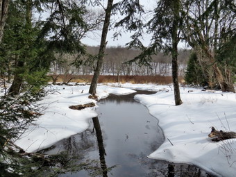
 We set off on the woods roads that leads to the register on the Quick Lake Trail. There were several sets of footprints and some cross country ski tracks. The snow was almost hard enough to support our weight, but we kept breaking through in most places. I knew this would be a tiring way to hike and thought Cindy might not be bale to make the whole loop. At the register, we continued straight ahead toward Frick Pond on the Quick Lake Trail. The snow on the trail had more track which had compacted the snow. The rough collection of footprints made hiking difficult as it kept turning our feet back and forth. There were a few places where small streams crossed and these had running water and ice but were easily crossed. I removed a few branches and pushed some away from the trail. We continued along the trail and I checked that the Lobdell Memorial was still standing. At Gravestone Junction we stayed to the left to follow the Quick Lake Trail down to the bridge at the outlet end of Frick Pond. We stopped at the bridge and I decided to take a few shots even though the skies were overcast. We continued across the bridge and around the west side of the pond crossing the muddy spot where our crew had done some work to improve drainage. I noticed that the two bridges on the west side of the pond needed some repair work before they would have to be replaced. Cindy let me know that she wanted to take the Big Rock Trail to Times Square and then make a decision which route we would take. At the junction with the Big Rock Trail, we turned right on the Big Rock Trail and continued along the west side of the wetlands at the head of the pond. There were fewer footprints now and soon they stopped meaning the hikers had turned around. We came to the wooden walkways which were covered in snow and ice so I decided to take some pictures. The wooden walkways can the very slippery when wet even when there is no ice. These walkways also need repair, a fact we have mentioned to both the DEC and the NYNJTC. Repairing them now will be much easier than replacing them later!
 We walked through the spruce tunnel and across two bridges. I looked to see if there were some photographic opportunities and decided to take a few shots before moving on. The north end of the pond is usually very wet and muddy but there were only a few spots. We came to the large blowdown across the trail which I had not been able to clear. I decided to walk around the blowdown to the left following the cross country skier. When we arrived at Times Square, there were snowmobile tracks on the Loggers Loop which would make walking easier. At Iron Wheel Junction there would be only a half mile downhill to get back to Frick Pond. Cindy made it clear she wanted to take the shortest way back to the car. I indicated the shortest way is not the easiest way but she was insistent. We turned right to complete the loop around Frick Pond on the Logger's Loop. This trail is a very gentle climb and then a slight descent to Gravestone Junction to complete the loop. There was only one set of footprints to follow and the snow was the deepest we had encounter. For the first time I thought that snowshoes would have made walking easier. I put my head down and kept a steady pace down and then up the hill. There were a few wet spots along the way but they were easy to avoid. As we passed the primitive campsites and privy, the skies were blue and the sun was shining. I stopped to take a few pictures and then continued on. We were soon back at Gravestone Junction where we turned left. We walked the Quick Lake Trail back to the trail register abed then the woods road to the car. It was 1:55 PM and we had hiked the 2.3 miles in 1 hour and 30 minutes with an elevation gain of 210 feet.
![]()
![]()
![]()
![]() On Friday, March 3rd I wanted get out for a short hike after a week of bad weather and numerous ambulance calls. I wanted it to be short as I knew I was the only EMT available for the ambulance corps. My morning had been filled with getting ready for Sunday's church service and a meeting for breakfast with another pastor. I decided to hike on Round Top for some exercise. I am lucky that I have a place so close to hike but it has become very familiar. I have found that even a short hike helps to keep my blood pressure in check and I am hoping I can get my weight down also. I started to get ready at 1:30 PM while Sheila was already prepared to go as she really likes to hike. She was lying on the floor with her front legs spread barking up a storm. It was 47 degrees on the back porch so I got dressed in my Mammut crew top without a baselayer. I wore my Railriders hiking pants which are expensive but last along time and have features like deep pockets and a generous cut which I really like. The pants have Velcro closures at the ankles. I decided to put on my Keen Durand hiking boots which fit well and are newer than what I have been wearing. I added a new pair of Xstance insoles in an effort to find the best support and cushioning for my feet. These insoles have shock absorbing gel pads, TPU arch support, and memory foam cushioning all wrapped in a breathable fabric. The insoles have been hyped by their manufacturer and they really do seem to deliver. I decided to take my Leki poles with external locks as the internal twist locks sometimes fail. I did don my Mammut hoody as it has enough zippers to dump heat if needed. I wore my OR Crocodile gaiters in case there was any show or mud. I was pretty sure I would not find any snow as all the snow in town had melted. At 1:55 PM we walked out the door to start the hike. I looked around and saw that the sky which had been blue and filled with puffy cotton candy clouds had changed to a dark overcast. I grabbed Sheila's leash from the car and we walked up the driveway. We walked to the parking lot at the Presbyterian Church and headed to the back of the church to the cemetery hill. We began the ascent of the steepest hill behind the church and continued directly up the hill to the trailhead. There were some patches of snow which I easily avoided. The hill is short but gets the circulation pumping and is the steepest and longest climb on the "trail." My goal was to make it all the way up the hill without stopping. At the top of the hill we stopped for minute so that I could observe the skies and hills all around us. We turned left and entered the woods to begin our hike. The trailhead was damp but as we entered the woods the trail was covered in 1 to 2 inches of snow! The increased elevation had led to more snow and the shade of the trees allowed it to stay around.
On Friday, March 3rd I wanted get out for a short hike after a week of bad weather and numerous ambulance calls. I wanted it to be short as I knew I was the only EMT available for the ambulance corps. My morning had been filled with getting ready for Sunday's church service and a meeting for breakfast with another pastor. I decided to hike on Round Top for some exercise. I am lucky that I have a place so close to hike but it has become very familiar. I have found that even a short hike helps to keep my blood pressure in check and I am hoping I can get my weight down also. I started to get ready at 1:30 PM while Sheila was already prepared to go as she really likes to hike. She was lying on the floor with her front legs spread barking up a storm. It was 47 degrees on the back porch so I got dressed in my Mammut crew top without a baselayer. I wore my Railriders hiking pants which are expensive but last along time and have features like deep pockets and a generous cut which I really like. The pants have Velcro closures at the ankles. I decided to put on my Keen Durand hiking boots which fit well and are newer than what I have been wearing. I added a new pair of Xstance insoles in an effort to find the best support and cushioning for my feet. These insoles have shock absorbing gel pads, TPU arch support, and memory foam cushioning all wrapped in a breathable fabric. The insoles have been hyped by their manufacturer and they really do seem to deliver. I decided to take my Leki poles with external locks as the internal twist locks sometimes fail. I did don my Mammut hoody as it has enough zippers to dump heat if needed. I wore my OR Crocodile gaiters in case there was any show or mud. I was pretty sure I would not find any snow as all the snow in town had melted. At 1:55 PM we walked out the door to start the hike. I looked around and saw that the sky which had been blue and filled with puffy cotton candy clouds had changed to a dark overcast. I grabbed Sheila's leash from the car and we walked up the driveway. We walked to the parking lot at the Presbyterian Church and headed to the back of the church to the cemetery hill. We began the ascent of the steepest hill behind the church and continued directly up the hill to the trailhead. There were some patches of snow which I easily avoided. The hill is short but gets the circulation pumping and is the steepest and longest climb on the "trail." My goal was to make it all the way up the hill without stopping. At the top of the hill we stopped for minute so that I could observe the skies and hills all around us. We turned left and entered the woods to begin our hike. The trailhead was damp but as we entered the woods the trail was covered in 1 to 2 inches of snow! The increased elevation had led to more snow and the shade of the trees allowed it to stay around.
Just before the first trail junction there was a large tree that had been across the trail. I had cut one end and then Brad and I had cut and removed the rest of the very large trunk. At the first trail junction, I followed Sheila as she turned right and started up the woods road which has the gentler approach of the two. We continued up the trail and passing by the rather larger tree I had cut by hand and removed from the trail. We reached the end of the woods road and turned left up the hill on the trail. We continued up the trail to the first trail junction with the upper blue trail. We turned left and walked the yellow trail along the base of Round Top to the next junction with the blue trail. The amount of snow increased to almost 3 inches. I was glad no trees had fallen across the trail and no more brush needed to be trimmed. When we reached the junction, I told Sheila "right" and she turned right on the blue trail and started to climb the hill. We turned right on the switchback in the blue trail which I had constructed to ease the erosion on the main trail and allow people to have a slightly more gentle climb. This trails sidehills a little and the snow made it slippery to walk. At the end of the switchback we turned right on the main blue trail and passed the white crossover trail on the way to the summit. We crossed over the summit which also had 3 inches of snow and started down the blue rail on the other side. This descent was slippery and I had to use my poles to get some traction. We again passed the white crossover trail continuing on to the yellow trail. We had not run into any blowdowns blocking the trail but we had removed a few small branches. We turned right and again walked along the yellow trail to the next junction with the blue trail. This time we turned left and headed down toward the lookout. There were a few slippery spots on the descents. When we reached the viewpoint, I noticed that the skies were darker and the sun was a yellow disc in the sky. We continued to follow the yellow trail as it descended steeply from the lookout to the first trail junction. I again had to use my poles and watch my footing on the slippery snow. We immediately turned around and started back up the yellow trail to the lookout. When the yellow trail turned right, we followed it back up passing the "Sitting Rock". At the first junction with the blue trail, we turned right and followed the yellow trail along the base of Round Top. At the next junction with the blue trail, we turned left and headed up the hill toward the summit. This was also a challenging ascent as the snow made the trail slippery especially after we had been over it once before. We continued passing the white crossover trail and headed toward the summit. We walked over the summit and down the other side. We turned left on the switchback to stay on the blue trail. The switchback took us out into the woods and then back to the main blue trail where we turned left. We walked down the hill to the yellow trail where we turned left to walk along the base of Round Top. At the junction with the blue trail, we turned right and walked down the trail to the woods road. We turned right on the woods road that took us downhill to the first trail junction. We turned left and walked out to the trailhead. We turned right and walked down the hill to the church parking lot. We crossed the parking lot and Rock Avenue to get to our driveway. When we arrived home, it was 3:15 PM and we had hiked about 2 miles in an 1 hour and 20 minutes.
![]()
![]()
![]()
![]()
![]() On Monday, February 26th I wanted to get out for a after a number of ambulance calls in our district and others. The problem was that I knew I might be the only EMT available for calls so I knew I would have to stay close to the house and keep the hike short. I asked Cindy if she would like to hike the Parksville Rail Trail from Fox Mountain Road to Parksville and back and she agreed. The hike is about 2.5 miles but I was hoping the falls would be flowing as they are beautiful. We started to get ready at 12:30 PM with the temperature at 36 degrees! Sheila could not contain her excitement as we were getting dressed as if she thought we might not hike again! The skies were blue but overcast with a slight breeze. I knew that the trail could be icy but would be covered with patches of snow from the last storm. I told Cindy to make sure to bring her spikes and I did the same. I put on my Mammut long-sleeved crew top without a baselayer. I wore a pair of Bauer First Ascent pants which are insulated against the cold and are slightly water repellant. I don't like the fit of these pants and have been looking for a replacement. I decided to put on my Keen Durand hiking boots which fit well and are newer than what I have been wearing. I added a new pair of Xstance insoles in an effort to find the best support and cushioning for my feet. These insoles have shock absorbing gel pads, TPU arch support, and memory foam cushioning all wrapped in a breathable fabric. The insoles have been hyped by their manufacturer and have lived up to that hype. I almost always take my Leki poles with external locks as the internal twist locks sometimes fail. I put on a light hat and took a pair of lightweight gloves. I did don my Mammut hoody as it has enough zippers to dump heat if needed. I put on my OR Crocodile gaiters to keep my lower legs warm and to resist the mud and water that I might kick up. At 12:45 PM we put our gear in the car and Sheila in the back seat. I headed out Old Route 17 and drove across the Flats. I took Old Route 17 and Service Road to the point where they meet Fox Mountain Road. There were no vehicles in the parking lot when we started to get ready for the hike.
On Monday, February 26th I wanted to get out for a after a number of ambulance calls in our district and others. The problem was that I knew I might be the only EMT available for calls so I knew I would have to stay close to the house and keep the hike short. I asked Cindy if she would like to hike the Parksville Rail Trail from Fox Mountain Road to Parksville and back and she agreed. The hike is about 2.5 miles but I was hoping the falls would be flowing as they are beautiful. We started to get ready at 12:30 PM with the temperature at 36 degrees! Sheila could not contain her excitement as we were getting dressed as if she thought we might not hike again! The skies were blue but overcast with a slight breeze. I knew that the trail could be icy but would be covered with patches of snow from the last storm. I told Cindy to make sure to bring her spikes and I did the same. I put on my Mammut long-sleeved crew top without a baselayer. I wore a pair of Bauer First Ascent pants which are insulated against the cold and are slightly water repellant. I don't like the fit of these pants and have been looking for a replacement. I decided to put on my Keen Durand hiking boots which fit well and are newer than what I have been wearing. I added a new pair of Xstance insoles in an effort to find the best support and cushioning for my feet. These insoles have shock absorbing gel pads, TPU arch support, and memory foam cushioning all wrapped in a breathable fabric. The insoles have been hyped by their manufacturer and have lived up to that hype. I almost always take my Leki poles with external locks as the internal twist locks sometimes fail. I put on a light hat and took a pair of lightweight gloves. I did don my Mammut hoody as it has enough zippers to dump heat if needed. I put on my OR Crocodile gaiters to keep my lower legs warm and to resist the mud and water that I might kick up. At 12:45 PM we put our gear in the car and Sheila in the back seat. I headed out Old Route 17 and drove across the Flats. I took Old Route 17 and Service Road to the point where they meet Fox Mountain Road. There were no vehicles in the parking lot when we started to get ready for the hike.
 Cindy decided to put on her spikes at the car while I decided to wait until they were needed. We started out on the trail at 12:55 PM with the temperature at 35 degrees under slighty overcast skies. The open trail just before the woods alternated between open dirt and patches of snow. We saw two sets of footprints heading out on trail and a set of prints from a large dog. Fortunately, there wasn't much snow and the rough surface was manageable giving us some traction so the spikes were not needed. We entered the trees which blocked the breeze but shaded the trail. I was a little cooler than I would have liked so I set a quick pace hoping to warm up. Areas of ice began in earnest almost immediately but most were covered with a layer of crusty snow allowing some traction. We found a medium-sized trunk across the trail. The tree looked like I could cut it with a hand saw and ax to get it off the trail. One look down to the Little Beaverkill showed the stream volume was reasonably high. I wondered about the condition of the falls and whether they would be frozen or not. Sheila was taking her own route and following her nose and getting very close to the edge of the trail where a steep drop led down to the river! We were soon at the wooden walkways and I decided the views were much like our previous hike. To keep warm, I took a little peak and continued to walk. The walkway's wooden surface was covered in a thick layer of ice making the footing slippery but, again, the crusty snow offered some traction. The ice problem comes from a rock slide that has blocked the culvert under the small bridge causing water, mud and stones to be diverted over the walkway. Unblocking the culvert and covering the walkways with some screening would help. This time it was a lot of water that had frozen on the bridge, the walkways, and the trail. We continued on the trail and found a few blowdowns that should be cleared. As we approached the falls, we could hear the sound of the falls roaring.
 When we arrived at the falls, we found that there was a lot of ice piled up downstream of the falls. There was also a lot of white ice at the falls and a good volume of water flowing. There was less ice than on our previous visit but it was still pretty. I decided that I wanted to stay warm and keep moving. We continued the hike on the trail but walked by the bench where a path leads down to the stream. This area was not that interesting and I just wanted to walk. The trail continued to be covered in ice and snow. I was not having any problem with traction even though I was not wearing spikes. Cindy had here spikes on and was marching along with a sure grip. We set a quick pace for the rest of the hike toward the Parksville end of the trail. Just after the gate at that end, I stopped and looked back to find that Cindy had stopped some distance behind me. I looked at the sign which outlines the milk that the O&W transported. The sign also mentions the large number of hotels that had been in the area. Since Cindy had not walked toward me, Sheila and I began walking toward her. When we reached Cindy, we headed back to the car. I knew I would not be taking any pictures and we set a rapid return pace. Just after the falls, I looked up and saw a group of 8 young women hiking toward us. I put Sheila on her leash and continued to walk along the side of the trail. As we passed, we all said "Hello" as we continued in our separate directions. I regretted failing to ask the group where they were from! We were back at the car at 1:55 PM after hiking 2.6 miles in exactly 1 hour which is faster than we had ever done the hike. There is virtually no elevation gain on the hike.

![]()
![]()
![]()
![]()
![]() On Tuesday, February 21st I got up early to find that instead of rain we had gotten a coating of snow and it was still snowing. I decided to get a little more sleep and then decide what to do. The previous day had seen a bunch of ambulance calls including one in the middle of the night. When I finally got up at 9:30 AM, the snow had stopped and was hanging on the trees. I decided I wanted to go across the street to Round Top to get some exercise and take pictures of the snow on the trees. By the time I ate and started to get dressed at 10:45 AM the temperature was up to 34 degrees and I could see the snow beginning to fall from the trees. Sheila was quitely watching my every move but I knew she was excited as we had not been out for several days. I decided to put on my Mammut long-sleeved crew top with a long-sleeved baselayer. I wore a pair of Bauer First Ascent pants which are insulated against the cold and are slightly water repellant. I don't like the fit of these pants and have been looking for a replacement. It will soon be time to permanently switch to a pair of insulated pants. I decided to put on my old Salomon B52 winter boots which are beginning to show their age. I made sure the shoes had a pair of Protalus insoles to support my aching feet. I took my Leki poles with external locks as the internal twist locks sometimes fail. I wore a warm but light hat and a pair of light gloves. I put on my OR Crocodile gaiters because of the wet snow. I also donned my Mammut hoody which has enough zippers to dump heat when it is needed. I carried my Kahtoola Microspikes to make sure I had some traction on the slippery snow if I needed it. At 11:05 AM we walked out the door to start the hike. I looked around and saw that the sky was beginning to become bright over Round Top. I grabbed Sheila's leash from the car and we walked up the driveway. We walked across the street and to the parking lot of the Presbyterian Church. We walked behind the church to get to the road up the hill to the trailhead.
On Tuesday, February 21st I got up early to find that instead of rain we had gotten a coating of snow and it was still snowing. I decided to get a little more sleep and then decide what to do. The previous day had seen a bunch of ambulance calls including one in the middle of the night. When I finally got up at 9:30 AM, the snow had stopped and was hanging on the trees. I decided I wanted to go across the street to Round Top to get some exercise and take pictures of the snow on the trees. By the time I ate and started to get dressed at 10:45 AM the temperature was up to 34 degrees and I could see the snow beginning to fall from the trees. Sheila was quitely watching my every move but I knew she was excited as we had not been out for several days. I decided to put on my Mammut long-sleeved crew top with a long-sleeved baselayer. I wore a pair of Bauer First Ascent pants which are insulated against the cold and are slightly water repellant. I don't like the fit of these pants and have been looking for a replacement. It will soon be time to permanently switch to a pair of insulated pants. I decided to put on my old Salomon B52 winter boots which are beginning to show their age. I made sure the shoes had a pair of Protalus insoles to support my aching feet. I took my Leki poles with external locks as the internal twist locks sometimes fail. I wore a warm but light hat and a pair of light gloves. I put on my OR Crocodile gaiters because of the wet snow. I also donned my Mammut hoody which has enough zippers to dump heat when it is needed. I carried my Kahtoola Microspikes to make sure I had some traction on the slippery snow if I needed it. At 11:05 AM we walked out the door to start the hike. I looked around and saw that the sky was beginning to become bright over Round Top. I grabbed Sheila's leash from the car and we walked up the driveway. We walked across the street and to the parking lot of the Presbyterian Church. We walked behind the church to get to the road up the hill to the trailhead.
 We began the ascent of the steepest hill behind the church. The ground was covered in places in a layer of snow but it was only about an inch deep. Other areas of the pavement had no snow at all. When I had finished, we continued directly up the hill to the trailhead. The hill is short but gets the circulation pumping and is the steepest and longest climb on the "trail." My goal is always to make it all the way up the hill without stopping which proved challenging as I have not been hiking as much as I would like and most of my hikes have been flat. The fact that I have been ill for almost a month did not help either! At the top of the hill we stopped so that I could take some photographs of the snow on the trees and the cemetery. I also took some shots across the valley to Beer Mountain. The snow had stopped and the views were relatively clear. The snow was clinging to the trees tenaciously but the increasing temperature and a slight breeze would soon take care of that. We turned left and entered the woods to begin our hike. The trailhead was covered in snow and as we entered the woods the snow still was only about an inch. I was surprised to see at peat one and maybe two sets of footprints in the snow. At other times I would have been disappointed at not being the first to hike the trails, but on this day I was happy to see the trails were getting used. Just before the first trail junction, we came to the spot where a large tree had fallen across the trail. I had cut one end of the tree with my ax and saw. Brad and I had finished the job. It was almost 2 feet in diameter and we had to cut it several times to move it off the trail. At the first trail junction, I followed Sheila as she continued straight ahead up the hill toward the lookout. When we reached the top of the trail, we walked off the trail to the left and out to the viewpoint. I dropped my pack and got out my camera. I took pictures of the snow on trees and then turned my attention to the view. I was able to see down to the school and the buildings in town. I could also see across the valley to the hills beyond where the trees were also eased in snow. I took a number of pictures and then told Shiela to go to the upper part of the lookout. I told her to sit and she posed for some pictures. When I was done, I packed up and walked to the upper lookout. We followed the yellow trail as it headed uphill toward the next trail junction. We passed the "sitting rock" and continued on the yellow trail to the first junction with the blue trail. At the junction we stopped so I could take some more pictures of the snow on the trees. I took a number of shots in all direction and the packed up to start hiking again. We turned right and walked the yellow trail along the base of Round Top to the next junction with the blue trail. The trees along the trail were covered in snow and weighed down enough to hang down into the trail. I noticed that one of the rock overhangs below the ledges still had several tarps forming a shelter. I saw no footprints leading to the area. We turned left at the next junction and began climbing the hill. On the way up the hill, we bypassed the white crossover trail and continued on the blue trail across the summit of Round Top. As we began down the other side, we bypassed the white crossover trail and turned left on the switchback in the blue trail. The switchback trail sidehills a little which makes it even harder to negotiate when it is slippery. We continued following the switchback as it took us out into the woods and then turned almost 180 degrees to bring us back to the main blue trail. We turned left and continued downhill on the blue trail. We followed the blue trail to the yellow trail. We turned left and walked on the yellow trail along the base of Round Top to the junction with the blue trail.
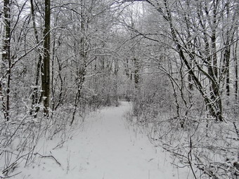 This time we turned right and walked down the yellow trail to the woods road. We walked along the woods road toward the first trail junction. Just before the first trail junction, I looked at the remains of the large blowdown I had cut and removed from the trail. Just passed this were the remains of a smaller blowdown I had cut up. This tree had hung over the trail for months but finally came down in the wind. I decided to do another figure 8 but without stopping to take pictures. We turned around at the first trail junction and started back up the woods road. We turned left when the yellow trail started up toward the first junction with the blue trail. We turned left and walked the yellow trail to the next junction with the blue trail. At the next trail junction we turned right on the blue trail and started up the hill. This trail was a little steeper but the snow was not very slippery. We turned right on the switchback and followed it out and back to the main blue trail. We continued on the main blue trail and again cross the summit to start down the other side. We continued down the other side where the footing on the descent was tricky. I hit one muddy spot and slipped but recovered before going down. At the junction with the yellow trail we turned right and again walked along the base of Round Top to the next junction with the blue trail. This time we turned left and continued on the yellow trail passing the "Sitting Rock" to the viewpoint. At the viewpoint we turned left and walked down the steep trail to the first trail junction. This time we continued out to the trailhead. At the trailhead we turned right and walked down the hill to the church parking lot. We crossed the parking lot and Rock Avenue to get to our driveway. When we arrived home, it was 12:35 PM and we had hiked a little more than 2 miles in an hour and 30 minutes including the time to take pictures and the increased difficulty from the snow.
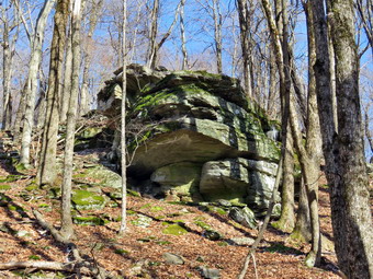
![]()
![]()
![]()
![]()
![]() On Saturday, February 18th, I wanted to get out for a longer hike after sticking to Round Top and the Parksville Rail Trail for several weeks. I was still fighting a cold that had kept me inside. In addition, track meets and numerous ambulance calls had limited ny outdoor time. I realized that the lack of exercise was affecting me physically and mentally. My son-in-law Brad was visiting and I knew he would want to go. I was trying to reclaim some sleep from a string of ambulance calls and slept in until 9:00 AM. I did some work around the house and then decided to get ready and go. Rather than travel too far I decided we would go to Frick Pond and hike the Flynn Trail where we could hike some uphill miles. This would give us some choices of how far we wanted to hike and the route we would take. As we started to get ready at 1:30 PM, the temperature on the back porch was 33 degrees. I knew it might be colder at the trailhead so I decided to put on my Mammut long-sleeved crew top with a long-sleeved baselayer. I put on a pair of RailRiders hiking pants which are expensive but last a long time and have features like deep pockets and a generous cut which I really like. I decided to put on my Keen Durand hiking boots which fit well and are newer than what I have been wearing. I added a new pair of Xstance insoles in an effort to find the best support and cushioning for my feet. These insoles have shock absorbing gel pads, TPU arch support, and memory foam cushioning all wrapped in a breathable fabric. The insoles have been hyped by their manufacturer and have lived up to that hype! I almost always take my Leki poles with external locks as the internal twist locks sometimes fail. I put on a light hat and took a pair of light gloves. I did don my Mammut hoody as it has enough zippers to dump heat if needed. I added my OR Crocodile gaiters in case there was any mud or Ione water. We put our gear in the back and Sheila in the backseat and headed out the DeBruce Road at 1:45 PM. After 6 miles, at Mongaup Pond Road, I turned left and continued to follow the road bearing left onto Beech Mountain Road at the fork. When we arrived in the parking area there were no cars parked in the larger lot but the small lot had four cars in it. I pulled into the smaller lot with Sheila acting as if she hadn't hiked in a month. I kept her in the car as we were getting ready as there was a car next to us with a dog. The temperature was 30 degrees and the skies were blue with white clouds with a slight breeze blowing. I wondered if I would be warm enough with my relatively light and undulated pants. I set my GPS as we got ready to head out on the Flynn Trail. I let Sheila out of the car and told her to cross the road to get to the Flynn Trail and to begin our hike at 2:00 PM.
On Saturday, February 18th, I wanted to get out for a longer hike after sticking to Round Top and the Parksville Rail Trail for several weeks. I was still fighting a cold that had kept me inside. In addition, track meets and numerous ambulance calls had limited ny outdoor time. I realized that the lack of exercise was affecting me physically and mentally. My son-in-law Brad was visiting and I knew he would want to go. I was trying to reclaim some sleep from a string of ambulance calls and slept in until 9:00 AM. I did some work around the house and then decided to get ready and go. Rather than travel too far I decided we would go to Frick Pond and hike the Flynn Trail where we could hike some uphill miles. This would give us some choices of how far we wanted to hike and the route we would take. As we started to get ready at 1:30 PM, the temperature on the back porch was 33 degrees. I knew it might be colder at the trailhead so I decided to put on my Mammut long-sleeved crew top with a long-sleeved baselayer. I put on a pair of RailRiders hiking pants which are expensive but last a long time and have features like deep pockets and a generous cut which I really like. I decided to put on my Keen Durand hiking boots which fit well and are newer than what I have been wearing. I added a new pair of Xstance insoles in an effort to find the best support and cushioning for my feet. These insoles have shock absorbing gel pads, TPU arch support, and memory foam cushioning all wrapped in a breathable fabric. The insoles have been hyped by their manufacturer and have lived up to that hype! I almost always take my Leki poles with external locks as the internal twist locks sometimes fail. I put on a light hat and took a pair of light gloves. I did don my Mammut hoody as it has enough zippers to dump heat if needed. I added my OR Crocodile gaiters in case there was any mud or Ione water. We put our gear in the back and Sheila in the backseat and headed out the DeBruce Road at 1:45 PM. After 6 miles, at Mongaup Pond Road, I turned left and continued to follow the road bearing left onto Beech Mountain Road at the fork. When we arrived in the parking area there were no cars parked in the larger lot but the small lot had four cars in it. I pulled into the smaller lot with Sheila acting as if she hadn't hiked in a month. I kept her in the car as we were getting ready as there was a car next to us with a dog. The temperature was 30 degrees and the skies were blue with white clouds with a slight breeze blowing. I wondered if I would be warm enough with my relatively light and undulated pants. I set my GPS as we got ready to head out on the Flynn Trail. I let Sheila out of the car and told her to cross the road to get to the Flynn Trail and to begin our hike at 2:00 PM.
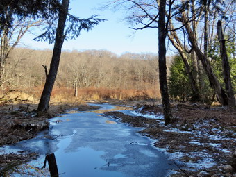 The Flynn Trail is sited along what used to be Beech Mountain Road which was the access for the Beech Mountain Boy Scout Camp. We walked the trail through the woods which was damp and even muddy in places. After a short walk we came to the first blowdown that I knew was present. The problem was that a large tree had fallen across the trail and its 2 foot diameter was more than I could handle, at least on this day. I had already cut the other trees that had been brought down and were encroaching on the trail or hanging over it. We hopped over the trunk and continued on the trail to the woods road. We turned right on the woods road and continued to set a good pace up the hill. The trail gains a little over 600 feet in 1.7 miles to the highest point at the junction with the Big Rock Trail. I noticed that I was breathing heavily as we walked up the trail. We passed the hemlock that used to form a tunnel but was cleared by the DEC. We began to find some small branches on the trail which we removed and continued to do so for the rest of the hike. The day was cool but beautiful with plenty of sun. I began to warm up but decided not to open any zippers on my hoody. On the way up the trail we came to the rock ledges on the right side of the trail. As we approached and the clearing to the right of the trail, I stopped to take some pictures of the rock ledges on the right side of the trail. It was a beautiful day and the sun was shining on the rocks and the trail. There were traces of the snow that had fallen the night before. I noticed that I was very relaxed and decided I had to get out more on hikes! I thought about visiting the clearing but decided I wanted to stay on the main trail. We kept walking uphill and clearing small and larger branches as we went. We were soon at the junction with the Big Rock Trail. I thought about extending the hike to Hodge Pond but in the end we turned left to walk down the Big Rock Trail. The trail continued to be damp but not muddy. The hike down the trail went well and more quickly than I expected. In several places, blowdowns that had been across the trail were gone thanks to the work of the snowmobile club. It was definitely easier than the uphill hike. This trail can be tricky as there are several levels that make it seem like the bottom of the hill.
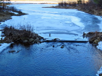 We were soon at Times Square and I thought about turning right to hike up and around the Logger's Loop to add some distance to our hike. I decided against this as it was getting late and we continued our hike by walking straight across Times Square to stay on the Big Rock Trail. Hiking goes quickly with Brad as we have interesting conversations especially about EMS. The Big Rock Trail around the back of Frick Pond can be very wet but on this day it was damp with a few muddy spots. There was still a very large blowdown across the trail which would require a chainsaw. I had trimmed some branches to make getting over it easier. We chose to hop over the large trunk and continue on the trail. We crossed the two small bridges over the inlets to the pond and I decided to stop to take a few pictures. The water under the first bridge was backed up from the wetlands and had a skim of ice. The area under the second bridge was now flowing but with a reduced volume. The sun was still out but slowly sinking giving a warm feeling to the setting. When we got to the area that was covered by tall evergreens, I pushed on through as I had taken pictures here very recently. We did stop at one point to allow a group of four hikers with one small dog to pass by. The wooden boardwalks continue to show wear with many boards loose and other beginning to rot. Much of the boardwalk now "floats" in midair as the supports are rotting. There was a light layer of snow on the walkways in a few spots and I took a few more shots. The rest of the trail was damp with several wet and muddy spots. At the next trail junction we turned left on the Quick Lake Trail to head for the bridge across the outlet of Frick Pond. We walked along the west side of Frick Pond to the bridge across the outlet of the pond. The mudhole was wet and muddy but the drainage work and the stepping stones did their job. I stopped at the bridge for a minute and took a few more photographs before we walked up the hill toward Gravestone Junction. We continued to Gravestone Junction and passed the Lobdell memorial marker. The marker is a memorial to two children who died in the 1930's in a fire that consumed their cabin. The trail to the memorial was well-worn but the marker was standing upright. The trail back to the register was wet and muddy in spots. Sheila alerted and I looked up to see a young couple walking toward us with a medium-sized dog. I pulled Sheila off to the side of the trail to let them pass. As they passed, we said "Hello". We passed the trail register heading toward the parking area. We continued straight ahead to follow the woods road out to the car in the small lot. We arrived at the car at 4:05 PM having hiked 4.0 miles in 2 hours and 5 minutes with an elevation gain of 700 feet.
![]()
![]()
![]()
![]()
![]() On Monday, February 13th I wanted to get out for a after a week of sickness, ambulance calls, and track commitments. The problem was that I knew I might be the only EMT available for calls so I knew I would have to stay close to the house and keep the hike short. I asked Cindy if she would like to hike the Parksville Rail Trail from Fox Mountain Road to Parksville and back and she agreed. The hike is less than 3 miles but I was hoping the falls would be flowing and that I could get some shots. We started to get ready at 12:45 PM with the temperature at 50 degrees! The temperature was one factor that encouraged us both. Sheila could not contain her excitement as we were getting dressed as if she thought we might not hike again! The skies were blue with fluffy white clouds and a slight breeze. I knew that the trail would be ice covered with some open areas and patches of snow. I told Cindy to make sure to bring her spikes and I did the same. I put on my Mammut long-sleeved crew top without a baselayer. I wore a pair of RailRiders hiking pants which are expensive but last a long time and have features like deep pockets and a generous cut which I really like. I had been wearing insulated pants but knew I would not need them on this day. I decided to put on my Keen Durand hiking boots which fit well and are newer than what I have been wearing. I added a new pair of Xstance insoles in an effort to find the best support and cushioning for my feet. These insoles have shock absorbing gel pads, TPU arch support, and memory foam cushioning all wrapped in a breathable fabric. The insoles have been hyped by their manufacturer and have lived up to that hype. I almost always take my Leki poles with external locks as the internal twist locks sometimes fail. I put on a light hat and took a pair of lightweight gloves. I did don my Mammut hoody as it has enough zippers to dump heat if needed. I put on my OR Crocodile gaiters to keep my lower legs warm and to resist the mud and water that I might kick up. I donned my Mammut hoody which has enough zippers to dump heat when it is needed. At 1:00 PM we put our gear in the car and Sheila in the back seat. I headed out Old Route 17 and drove across the Flats. I took Old Route 17 and Service Road to the point where they meet Fox Mountain Road. There was one pickup truck in the parking lot when we started to get ready for the hike. Just before we started out, a couple with their very large Mastiff came walking toward the parking area on the road from Parksville. I put Sheila in the backseat as the dog was not on a leash! The couple stated their dog was friendly and I responded "ours is sometimes." The couple laughed, got in their car and drove away.
On Monday, February 13th I wanted to get out for a after a week of sickness, ambulance calls, and track commitments. The problem was that I knew I might be the only EMT available for calls so I knew I would have to stay close to the house and keep the hike short. I asked Cindy if she would like to hike the Parksville Rail Trail from Fox Mountain Road to Parksville and back and she agreed. The hike is less than 3 miles but I was hoping the falls would be flowing and that I could get some shots. We started to get ready at 12:45 PM with the temperature at 50 degrees! The temperature was one factor that encouraged us both. Sheila could not contain her excitement as we were getting dressed as if she thought we might not hike again! The skies were blue with fluffy white clouds and a slight breeze. I knew that the trail would be ice covered with some open areas and patches of snow. I told Cindy to make sure to bring her spikes and I did the same. I put on my Mammut long-sleeved crew top without a baselayer. I wore a pair of RailRiders hiking pants which are expensive but last a long time and have features like deep pockets and a generous cut which I really like. I had been wearing insulated pants but knew I would not need them on this day. I decided to put on my Keen Durand hiking boots which fit well and are newer than what I have been wearing. I added a new pair of Xstance insoles in an effort to find the best support and cushioning for my feet. These insoles have shock absorbing gel pads, TPU arch support, and memory foam cushioning all wrapped in a breathable fabric. The insoles have been hyped by their manufacturer and have lived up to that hype. I almost always take my Leki poles with external locks as the internal twist locks sometimes fail. I put on a light hat and took a pair of lightweight gloves. I did don my Mammut hoody as it has enough zippers to dump heat if needed. I put on my OR Crocodile gaiters to keep my lower legs warm and to resist the mud and water that I might kick up. I donned my Mammut hoody which has enough zippers to dump heat when it is needed. At 1:00 PM we put our gear in the car and Sheila in the back seat. I headed out Old Route 17 and drove across the Flats. I took Old Route 17 and Service Road to the point where they meet Fox Mountain Road. There was one pickup truck in the parking lot when we started to get ready for the hike. Just before we started out, a couple with their very large Mastiff came walking toward the parking area on the road from Parksville. I put Sheila in the backseat as the dog was not on a leash! The couple stated their dog was friendly and I responded "ours is sometimes." The couple laughed, got in their car and drove away.
Cindy decided to put on her spikes at the car while I decided to wait until they were needed. We started out on the trail at 1:45 PM with the temperature still at 50 degrees under sunny skies. The open trail just before the woods was bare without any ice or snow. We saw two sets of footprints heading out but not back on trail. These were accompanied by a set of huge canine footprints. Fortunately, there wasn't much snow and the rough surface was manageable giving us some traction so the spikes were not needed, yet. We entered the trees which blocked the breeze but shaded the trail. The ice began in earnest almost immediately. We found a medium-sized trunk across the trail. The tree looked like I could cut it with a hand saw and ax to get it off the trail. One look down to the Little Beaverkill showed the stream volume was reasonably high. I wondered about the condition of the falls and whether they would be frozen or not. Sheila was taking her own route and following her nose. We were trying to hike quickly but the ice was slowing me down while Cindy was having no problems. We were soon at the wooden walkways where we stopped so I could take some pictures of the river below. Before taking my shots, I sat on the bench and put on my spikes. The sun on the river made a pretty picture with the blue skies and white clouds. I took some shots of the river and the walkways. I also took pictures of the old auction house right on the road. We continued over the walkways where the wooden surface was covered in a thick layer of ice making the footing slippery. We wondered how the other couple had made it across the ice without spikes or poles! The ice problem comes from a rock slide that has blocked the culvert under the small bridge causing water, mud and stones to be diverted over the walkway. Unblocking the culvert and covering the walkways with some screening would help. This time it was a lot of water that had frozen on the bridge, the walkways, and the trail. I made sure to take some pictures of the mess. We continued on the trail and found a few blowdowns that should be cleared. As we approached the falls, we could hear the sound of the falls roaring.
When we arrived at the falls, we found that there was a lot of ice piled up downstream of the falls. There was also a lot of white ice at the falls and a good volume of water flowing. I looked at the path down to the base of the falls and found it covered in snow on top of ice. I decided to work my way down the path and take pictures of the falls and stream from the stream bank. I started to work my way down the icy bank removing a few branches as I descended. After a sketchy descent, I was finally on the edge of the stream. Sheila, of course, followed me down. I put down my pack and got out my camera. I took shots of the entire area toward the falls and some more downstream. I took some close-up pictures of the falls from slightly different angles. When I was done, I put the camera back in the pack. The climb back up to the trail was easier than I thought it might be. The are above the falls was very icy but I managed to get some pictures. I took shots of the falls from above near the picnic bench and a few of the area upstream. I moved upstream some and got some good shots of the main falls and the falls above. When I was done, we continued the hike on the trail but walked by the bench where a path leads down to the stream. This area was not that interesting and I just wanted to walk. The trail continued to be covered in ice. We set a quick pace for the rest of the hike toward the Parksville end of the trail. Just after the gate at that end, we stopped at the sign which outlines the milk that the O&W transported. The sign also mentions the large number of hotels that had been in the area. We turned around and headed back to the car. I knew I would not be taking any more pictures and we set a rapid return pace. We were back at the car at 2:35 PM after hiking 2.8 miles in 1 hour and 20 minutes including the stopped time for pictures. There is virtually no elevation gain on the hike.
![]()
![]()
![]()
![]() On Monday, February 6th I decided I wanted to go across the street to Round Top to get some exercise after more than a week of not getting out while trying to recover from a cold. I asked Cindy if she wanted to go with us but she declined as she does not like to climb hills. It was 32 degrees with some sun as I started to get ready at 11:30 AM. Sheila was quitely watching my every move but I knew she was excited as we had not been out for some time. I looked at the hill across the street and did not see very much snow so I did not take my pack and spikes. I decided to put on my Mammut long-sleeved crew top with a long-sleeved baselayer. I wore a pair of RailRiders hiking pants which are expensive but last a long time and have features like deep pockets and a generous cut which I really like. I had been wearing insulated pants but knew I would not need them on this day. I decided to put on my Keen Durand hiking boots which fit well and are newer than what I have been wearing. I added a new pair of Xstance insoles in an effort to find the best support and cushioning for my feet. These insoles have shock absorbing gel pads, TPU arch support, and memory foam cushioning all wrapped in a breathable fabric. The insoles have been hyped by their manufacturer and have lived up to that hype. I almost always take my Leki poles with external locks as the internal twist locks sometimes fail. I put on a light hat and took a pair of lightweight gloves. I did don my Mammut hoody as it has enough zippers to dump heat if needed. I put on my OR Crocodile gaiters to keep my lower legs warm. I donned my Mammut hoody which has enough zippers to dump heat when it is needed. At 11:45 AM we walked out the door to start the hike. I looked around and saw that the sky was blue over Round Top and the air was still. I grabbed Sheila's leash from the car and we walked up the driveway. We walked across the street and continued through the field next to the Presbyterian Church. We walked behind the church to get to the road up the hill to the trailhead.
On Monday, February 6th I decided I wanted to go across the street to Round Top to get some exercise after more than a week of not getting out while trying to recover from a cold. I asked Cindy if she wanted to go with us but she declined as she does not like to climb hills. It was 32 degrees with some sun as I started to get ready at 11:30 AM. Sheila was quitely watching my every move but I knew she was excited as we had not been out for some time. I looked at the hill across the street and did not see very much snow so I did not take my pack and spikes. I decided to put on my Mammut long-sleeved crew top with a long-sleeved baselayer. I wore a pair of RailRiders hiking pants which are expensive but last a long time and have features like deep pockets and a generous cut which I really like. I had been wearing insulated pants but knew I would not need them on this day. I decided to put on my Keen Durand hiking boots which fit well and are newer than what I have been wearing. I added a new pair of Xstance insoles in an effort to find the best support and cushioning for my feet. These insoles have shock absorbing gel pads, TPU arch support, and memory foam cushioning all wrapped in a breathable fabric. The insoles have been hyped by their manufacturer and have lived up to that hype. I almost always take my Leki poles with external locks as the internal twist locks sometimes fail. I put on a light hat and took a pair of lightweight gloves. I did don my Mammut hoody as it has enough zippers to dump heat if needed. I put on my OR Crocodile gaiters to keep my lower legs warm. I donned my Mammut hoody which has enough zippers to dump heat when it is needed. At 11:45 AM we walked out the door to start the hike. I looked around and saw that the sky was blue over Round Top and the air was still. I grabbed Sheila's leash from the car and we walked up the driveway. We walked across the street and continued through the field next to the Presbyterian Church. We walked behind the church to get to the road up the hill to the trailhead.
We began the ascent of the steepest hill behind the church. The pavement was almost completely clear of snow and ice and I was glad I had not worn my spikes. We continued directly up the hill to the trailhead. The hill is short but gets the circulation pumping and is the steepest and longest climb on the "trail." My goal is always to make it all the way up the hill without stopping which was challenging as I have not been hiking as much as I would like and most of my hikes have been flat. At the top of the hill we stopped so that I could look around at the hills which seemed to be covered in snow. We turned left and entered the woods to begin our hike. The trailhead was mostly clear of snow and ice and as we entered the woods this continued. Just before the first trail junction, we came to the spot where a large tree had fallen across the trail. I had cut one end of the tree with my ax and saw. Brad and I had finished the job. It was almost 2 feet in diameter and we had to cut it several times to move it off the trail. At the first trail junction, I followed Sheila as she continued straight ahead up the hill toward the lookout. When we reached the top of the trail, we walked off the trail to the left to the upper lookout. I was able to see down to the school and the buildings in town. I could also see across to the hills on the other side of town. When I was done, we followed the yellow trail as it headed uphill toward the next trail junction. We passed the "sitting rock" and continued on the yellow trail to the first junction with the blue trail. At the junction we stopped and I could see there was a lot of packed and frozen snow on the hill on the blue trail. We turned right and walked the yellow trail along the base of Round Top to the next junction with the blue trail. There was some snow on the trail which was packed from people using the trail. I noticed that one of the rock overhangs below the ledges still had several tarps forming a shelter. I saw no footprints leading to the area. On the way up the hill, we bypassed the white crossover trail and continued on the blue trail across the summit of Round Top where there was the most snow. As we began down the other side, the packed snow and ice were very slippery making the walk very interesting. We bypassed the white crossover trail and turned left on the switchback in the blue trail. The switchback trail sidehills a little which makes it even harder to negotiate when it is slippery. I had to walk on the sides of the trail to get some traction. We continued following the switchback as it took us out into the woods and then turned almost 180 degrees to bring us back to the main blue trail. We turned left and continued downhill on the blue trail with me picking my way carefully. We followed the blue trail to the yellow trail. We turned left and walked on the yellow trail along the base of Round Top to the junction with the blue trail.
This time we turned right and walked down the yellow trail to the woods road. We walked along the woods road toward the first trail junction. Just before the first trail junction, I looked at the remains of the large blowdown I had cut and removed from the trail. Just passed this were the remains of a smaller blowdown I had cut up. This tree had hung over the trail for months but finally came down in the wind. I decided to do another figure 8 so we turned around at the first trail junction and started back up the woods road. We turned left when the yellow trail started up toward the first junction with the blue trail. We turned left and walked the yellow trail to the next junction with the blue trail. At the next trail junction we turned right on the blue trail and started up the hill. This trail was a little steeper and I wished I had brought my spikes. When we reached the switchback, I decided to continue up the main blue trail. The walk up the steep section was easier than I thought it would be. We continued up the trail and over the summit before starting down the other side. This part of the trail was slippery but not as bad as the steeper side. At the bottom of the trail we turned right on the yellow trail. We again walked along the base of Round Top to the next junction with the blue trail. This time we turned left and continued on the yellow trail passing the "Sitting Rock" to the viewpoint. At the viewpoint we turned left and walked down the steep trail to the first trail junction. This time we continued out to the trailhead. At the trailhead we turned right and walked down the hill to the church parking lot. We crossed the parking lot and Rock Avenue to get to our driveway. When we arrived home, it was 1:15 PM and we had hiked a little more than 2 miles in an hour and 30 minutes.
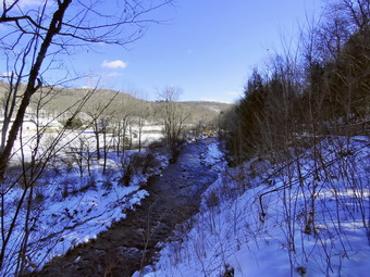
![]()
![]()
![]()
![]()
![]() On Saturday, January 28th I wanted to get out for only the second hike of the week. I am still involved in track practice and had a family commitment that consumed the middle of the week. The problem was that I knew I might be the only EMT available for calls so I knew I would have to stay close to the house and keep the hike short. I asked Cindy if she would like to hike the Parksville Rail Trail from Fox Mountain Road to Parksville and back and she agreed. The hike is less than 3 miles but I was hoping the falls would be flowing and that I could get some shots. We started to get ready at 10:15 AM with the temperature at 33 degrees. Sheila could not contain her excitement as we were getting dressed as if she thought we might not hike again! The skies were blue with fluffily white clouds and a slight breeze. I knew that the trail would be snow covered and frozen but suspected there might be some open water and mud. I put on my Mammut long-sleeved crew top with a long sleeved baselayer. I wore a pair of Bauer First Ascent pants which are insulated against the cold and slightly water repellant. I decided to put on my old Salomon B52 boots which have lasted many seasons but still fit well. I made sure I had a pair of Protalus in the shoes as they, like many other top brand hiking shoes. Have only a thin, non-supportive insole. I took my Leki poles with external locks as the internal twist locks sometimes fail. I wore a heavier fleece hat and a pair of light gloves. I put on my OR Crocodile gaiters to keep my lower legs warm and to resist the snow that I might kick up. I donned my Mammut hoody which has enough zippers to dump heat when it is needed. At 10:30M we put my gear in the car and Sheila in the back seat. We went to the post office and then I headed out Old Route 17 and drove across the Flats. I took Old Route 17 and Service Road to the point where they meet Fox Mountain Road. There were no cars in the parking lot when we started out on the trail at 10:45 AM.
On Saturday, January 28th I wanted to get out for only the second hike of the week. I am still involved in track practice and had a family commitment that consumed the middle of the week. The problem was that I knew I might be the only EMT available for calls so I knew I would have to stay close to the house and keep the hike short. I asked Cindy if she would like to hike the Parksville Rail Trail from Fox Mountain Road to Parksville and back and she agreed. The hike is less than 3 miles but I was hoping the falls would be flowing and that I could get some shots. We started to get ready at 10:15 AM with the temperature at 33 degrees. Sheila could not contain her excitement as we were getting dressed as if she thought we might not hike again! The skies were blue with fluffily white clouds and a slight breeze. I knew that the trail would be snow covered and frozen but suspected there might be some open water and mud. I put on my Mammut long-sleeved crew top with a long sleeved baselayer. I wore a pair of Bauer First Ascent pants which are insulated against the cold and slightly water repellant. I decided to put on my old Salomon B52 boots which have lasted many seasons but still fit well. I made sure I had a pair of Protalus in the shoes as they, like many other top brand hiking shoes. Have only a thin, non-supportive insole. I took my Leki poles with external locks as the internal twist locks sometimes fail. I wore a heavier fleece hat and a pair of light gloves. I put on my OR Crocodile gaiters to keep my lower legs warm and to resist the snow that I might kick up. I donned my Mammut hoody which has enough zippers to dump heat when it is needed. At 10:30M we put my gear in the car and Sheila in the back seat. We went to the post office and then I headed out Old Route 17 and drove across the Flats. I took Old Route 17 and Service Road to the point where they meet Fox Mountain Road. There were no cars in the parking lot when we started out on the trail at 10:45 AM.
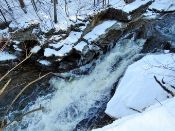 I did not bring my GPS unit as we had hiked the trail so many times before. I had not brought our snowshoes but I had brought my spikes in case they became necessary. Unfortunately, Cindy had not brought her spikes but I knew she could use mine. The open trail just before the woods was covered in frozen snow and the breeze made it feel even cooler. We saw only one set of footprints heading out and back on trail accompanied by a set of canine footprints. Fortunately, there wasn't much snow and the rough surface was manageable giving us some traction so the spikes were not needed. We entered the trees which blocked the breeze. The spots that usually have open water were frozen and covered with snow. Almost immediately we found a medium-sized trunk across the trail. The tree looked like I could cut it with a hand saw and ax to get it off the trail. One look down to the Little Beaverkill showed the stream volume was reasonably high. I wondered about the condition of the falls and whether they would be frozen or not. Sheila was taking her own route and following her nose. We were trying to hike quickly but the rough snow and patches of ice were slowing us down. We did not have to criss-cross the trail as everything was frozen solid. We were soon at the wooden walkways where we stopped so I could take some pictures of the river below. The sun on the river made a pretty picture. I took some shots of the river and the walkways. I also took pictures of a house high on a hill across the river and the old auction house right on the road. We continued over the walkways where the wooden surface was covered in a thin layer of ice with snow over the top making the footing slippery. Beyond the far end of the bridge was some running water and some ice. The problem is that a rock slide has blocked the culvert under the small bridge causing water, mud and stones to be diverted over the walkway. Unblocking the culvert and covering the walkways with some screening would help. We continued on the trail and found a few blowdowns that should be cleared. As we approached the falls, we could hear the sound of the falls roaring.
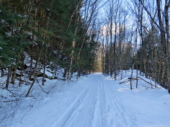 When we arrived at the falls, we found that there was not as much ice as last time but the flow was good. I looked at the path down to the base of the falls and found it covered in snow on top of ice. I decided not to work my way down the path and just take pictures of the falls and stream from above on the bank. I put down my pack and got out my camera. I took shots of the falls from above near the picnic bench and a few of the area upstream. I moved downstream to get a few picture of the rapids below the falls. I also moved upstream some and got some good shots of the main falls and the falls above. When I was done, we continued the hike on the trail but walked by the bench where a path leads down to the stream. This area was not that interesting and I just wanted to walk. The trail continued to be covered in frozen snow with some patches of ice frozen solid. We set a quick pace for the rest of the hike toward the Parksville end of the trail. Just after the gate at that end, we stopped at the sign which outlines the milk that the O&W transported. The sign also mentions the large number of hotels that had been in the area. We turned around and headed back to the car. I knew I would not be taking any more pictures and we set a rapid return pace. We were back at the car at 12:05 PM after hiking 2.8 miles in 1 hour and 20 minutes including the stopped time for pictures. There is virtually no elevation gain on the hike.
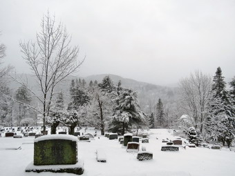
![]()
![]()
![]()
![]()
![]() On Monday, January 23rd I got up early to respond on an ambulance call. When I returned, I pick up Cindy at home and we went to eat at Caf� 43. This place is small but had great food for breakfast and lunch. When we returned home, I found that all schools were closed and that there would be no track meet in the afternoon. I decided I wanted to go across the street to Round Top to get some exercise and take pictures of the snow on the trees. I asked Cindy if she wanted to go with us but she declined. It was 31 degrees and still snowing lightly when I seated to get ready at 10:30 AM. Sheila was quitely watching my every move but I knew she was excited as we had not been out for a week. I decided to put on my Mammut long-sleeved crew top with a long-sleeved baselayer. I wore a pair of Bauer First Ascent pants which are insulated against the cold and are slightly water repellant. I don't like the fit of these pants and have been looking for a replacement. It will soon be time to permanently switch to a pair of insulated pants. I decided to put on my old Salomon B52 winter boots which are beginning to show there age. I made sure the shoes had a pair of Protalus insoles to support my aching feet. I took my Leki poles with external locks as the internal twist locks sometimes fail. I wore a warm fleecy hat and a pair of light gloves. I packed a warmer pair of gloves, and put on my OR Crocodile gaiters because of the heavy wet snow. I also donned my Mammut hoody which has enough zippers to dump heat when it is needed. I decided to put on my Kahtoola Microspikes to make sure I had some traction on the slippery snow. At 10:45 AM we walked out the door to start the hike. I looked around and saw that the sky was overcast over Round Top and snow was till falling. I grabbed Sheila's leash from the car and we walked up the driveway. We walked across the street and continued through the field next to the Presbyterian Church. We walked behind the church to get to the road up the hill to the trailhead.
On Monday, January 23rd I got up early to respond on an ambulance call. When I returned, I pick up Cindy at home and we went to eat at Caf� 43. This place is small but had great food for breakfast and lunch. When we returned home, I found that all schools were closed and that there would be no track meet in the afternoon. I decided I wanted to go across the street to Round Top to get some exercise and take pictures of the snow on the trees. I asked Cindy if she wanted to go with us but she declined. It was 31 degrees and still snowing lightly when I seated to get ready at 10:30 AM. Sheila was quitely watching my every move but I knew she was excited as we had not been out for a week. I decided to put on my Mammut long-sleeved crew top with a long-sleeved baselayer. I wore a pair of Bauer First Ascent pants which are insulated against the cold and are slightly water repellant. I don't like the fit of these pants and have been looking for a replacement. It will soon be time to permanently switch to a pair of insulated pants. I decided to put on my old Salomon B52 winter boots which are beginning to show there age. I made sure the shoes had a pair of Protalus insoles to support my aching feet. I took my Leki poles with external locks as the internal twist locks sometimes fail. I wore a warm fleecy hat and a pair of light gloves. I packed a warmer pair of gloves, and put on my OR Crocodile gaiters because of the heavy wet snow. I also donned my Mammut hoody which has enough zippers to dump heat when it is needed. I decided to put on my Kahtoola Microspikes to make sure I had some traction on the slippery snow. At 10:45 AM we walked out the door to start the hike. I looked around and saw that the sky was overcast over Round Top and snow was till falling. I grabbed Sheila's leash from the car and we walked up the driveway. We walked across the street and continued through the field next to the Presbyterian Church. We walked behind the church to get to the road up the hill to the trailhead.
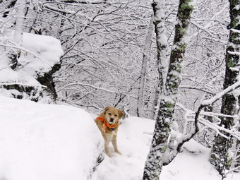 We began the ascent of the steepest hill behind the church. The ground was covered in a layer of snow but it was only about an inch deep. I stopped at the bottom to take some shots of the fresh snow on the road and in the cemetery. When I had finished, we continued directly up the hill to the trailhead. The hill is short but gets the circulation pumping and is the steepest and longest climb on the "trail." My goal is always to make it all the way up the hill without stopping which was challenging as I have not been hiking as much as I would like and most of my hikes have been flat. At the top of the hill we stopped so that I could take some photographs of the snow on the trees and the cemetery. I also took some shots across the valley to Beer Mountain. The clouds and the snow falling preventing me from getting clear shots and the views were limited. We turned left and entered the woods to begin our hike. The trailhead was covered in snow and as we entered the woods the show deepened but there was never more than 3 inches. The snow was wet and heavy and it immediately began to clump on my spikes. I had to keep scuffing my feet to get rid of the clumps. Just before the first trail junction, we came to the spot where a large tree had fallen across the trail. I had cut one end of the tree with my ax and saw. Brad and I had finished the job. It was almost 2 feet in diameter and we had to cut it several times to move it off the trail. At the first trail junction, I followed Sheila as she continued straight ahead up the hill toward the lookout. When we reached the top of the trail, we walked off the trail to the left and out to the viewpoint. I dropped my pack and got out my camera. I took pictures of the snow on threes and then turned my attention to the view. I was able to see down to the school and the buildings in town but the rest of the view was obscured by the falling snow. I took my pictures and then told Shiela to go to the upper part of the lookout. I told her to sit and she posed for some pictures. When I was done, I packed up and walked to the upper lookout. We followed the yellow trail as it headed uphill toward the next trail junction. We passed the "sitting rock" and continued on the yellow trail to the first junction with the blue trail. I was still getting snow clumping on my spikes but I was glad I had them. At the junction we stopped so I could take some more pictures of the snow on the trees. I took a number of shots in all direction and the packed up to start hiking again. We turned right and walked the yellow trail along the base of Round Top to the next junction with the blue trail. The trees along the trail were covered in snow and weighed down enough to hang down into the trail. I noticed that one of the rock overhangs below the ledges still had several tarps forming a shelter. I saw not footprints leading to the area. On the way up the hill, we bypassed the white crossover trail and continued on the blue trail across the summit of Round Top where the snow was the deepest. As we began down the other side, we bypassed the white crossover trail and turned left on the switchback in the blue trail. The switchback trail sidehills a little which makes it even harder to negotiate when it is slippery. We continued following the switchback as it took us out into the woods and then turned almost 180 degrees to bring us back to the main blue trail. We turned left and continued downhill on the blue trail. We followed the blue trail to the yellow trail. We turned left and walked on the yellow trail along the base of Round Top to the junction with the blue trail.
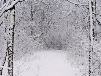 This time we turned right and walked down the yellow trail to the woods road. We walked along the woods road toward the first trail junction. The snow was really clumping now on both feet. Just before the first trail junction, I looked at the remains of the large blowdown I had cut and removed from the trail. Just passed this were the remains of a smaller blowdown I had cut up. This tree had hung over the trail for months but finally came down in the wind. I decided to do another figure 8 but without stopping to take pictures. We turned around at the first trail junction and started back up the woods road. We turned left when the yellow trail started up toward the first junction with the blue trail. We turned left and walked the yellow trail to the next junction with the blue trail. At the next trail junction we turned right on the blue trail and started up the hill. This trail was a little steeper and the spikes helped despite the clumping. We turned right on the switchback and followed it out and back to the main blue trail. We almost immediately turned right on the white crossover trail and followed it along the shoulder of Round Top to the blue trail on the other side. I wanted to make sure there were no blowdowns blocking the trail. We turned right and walked down the other side to the junction with the yellow trail. At the junction with the yellow trail we turned right and again walked along the base of Round Top to the next junction with the blue trail. This time we turned left and continued on the yellow trail passing the "Sitting Rock" to the viewpoint. At the viewpoint we turned left and walked down the steep trail to the first trail junction. This time we continued out to the trailhead. At the trailhead we turned right and walked down the hill to the church parking lot. We crossed the parking lot and Rock Avenue to get to our driveway. When we arrived home, it was 12:15 PM and we had hiked a little more than 2 miles in an hour and 30 minutes including the time to take pictures. I had gotten home just in time to go on the next ambulance call!
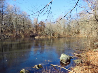
![]()
![]()
![]()
![]()
![]() On Monday, January 16th, I wanted to get in a hike with Cindy somewhere away from Livingston Manor. Whenever I am home, I always respond to ambulance call. If I am near home on a hike, I often interrupt the hike to go on a call. I wanted to go to a new place to hike and chose Stewart State Forest near Newburgh. The area has many multipurpose trail, bike trails and woods roads running through it. In addition there are two roads, Ridge Road and Maple Avenue that run north to south through the area but are closed to traffic. The biggest attraction is a boardwalk over the Great Swamp. Cindy likes short, flat hikes and I thought the route I had planned would be relatively flat but could be around 6 miles. When we got up at around 8:00 AM the temperature was only 15 degrees so we did some chores around the house. We started to get ready at 9:30 AM with the temperature at 26 degrees. Sheila certainly was happy to go hiking but was lying still playing the 'good dog'. I put on my Patagonia long-sleeved wool quarter-zip top with a short-sleeved baselayer. I wore a pair of Bauer First Ascent pants which are insulated against the cold and are slightly water repellant. I don't like the fit of these pants and have been looking for a replacement. It will soon be time to permanently switch to a pair of insulated pants. I decided to put on my Keen Durand hiking boots which fit well and are newer than what I have been wearing. I added a new pair of Xstance insoles in an effort to find the best support and cushioning for my feet. These insoles have shock absorbing gel pads, TPU arch support, and memory foam cushioning all wrapped in a breathable fabric. The insoles have been hyped by their manufacturer and have lived up to that hype. I took my Leki poles with external locks as the internal twist locks sometimes fail. I wore a warm fleecy hat and a pair of light gloves. I packed a warmer pair of gloves, and put on my OR Crocodile gaiters because of the possibility of water and mud. I also donned my Mammut hoody which has enough zippers to dump heat when it is needed. We left the house at 10:00 AM as I drove out to State Route 17 toward Monticello. I continued on the Quickway to exit 116. At the end of the exit I turned left on Route 17K and continued on through Montgomery heading toward Newburgh. After 15 miles, I turned right onto Ridge Road and continued about a mile to the parking area. I turned left on Maple Avenue and the immediately right into the parking area. The parking was beginning to fill up and it seemed that most of the people were bikers. We parked and got ready to hike with the temperature still a cool 35 degrees with a breeze. I put Sheila on her leash and set my GPS. I left my poles in the car as I expected a relatively flat route and I did not know how much I would keep Sheila on her leash. We started the hike by walking out the blue blazed Scofiled Trail at the back left corner of the parking area at 11:05 AM.
On Monday, January 16th, I wanted to get in a hike with Cindy somewhere away from Livingston Manor. Whenever I am home, I always respond to ambulance call. If I am near home on a hike, I often interrupt the hike to go on a call. I wanted to go to a new place to hike and chose Stewart State Forest near Newburgh. The area has many multipurpose trail, bike trails and woods roads running through it. In addition there are two roads, Ridge Road and Maple Avenue that run north to south through the area but are closed to traffic. The biggest attraction is a boardwalk over the Great Swamp. Cindy likes short, flat hikes and I thought the route I had planned would be relatively flat but could be around 6 miles. When we got up at around 8:00 AM the temperature was only 15 degrees so we did some chores around the house. We started to get ready at 9:30 AM with the temperature at 26 degrees. Sheila certainly was happy to go hiking but was lying still playing the 'good dog'. I put on my Patagonia long-sleeved wool quarter-zip top with a short-sleeved baselayer. I wore a pair of Bauer First Ascent pants which are insulated against the cold and are slightly water repellant. I don't like the fit of these pants and have been looking for a replacement. It will soon be time to permanently switch to a pair of insulated pants. I decided to put on my Keen Durand hiking boots which fit well and are newer than what I have been wearing. I added a new pair of Xstance insoles in an effort to find the best support and cushioning for my feet. These insoles have shock absorbing gel pads, TPU arch support, and memory foam cushioning all wrapped in a breathable fabric. The insoles have been hyped by their manufacturer and have lived up to that hype. I took my Leki poles with external locks as the internal twist locks sometimes fail. I wore a warm fleecy hat and a pair of light gloves. I packed a warmer pair of gloves, and put on my OR Crocodile gaiters because of the possibility of water and mud. I also donned my Mammut hoody which has enough zippers to dump heat when it is needed. We left the house at 10:00 AM as I drove out to State Route 17 toward Monticello. I continued on the Quickway to exit 116. At the end of the exit I turned left on Route 17K and continued on through Montgomery heading toward Newburgh. After 15 miles, I turned right onto Ridge Road and continued about a mile to the parking area. I turned left on Maple Avenue and the immediately right into the parking area. The parking was beginning to fill up and it seemed that most of the people were bikers. We parked and got ready to hike with the temperature still a cool 35 degrees with a breeze. I put Sheila on her leash and set my GPS. I left my poles in the car as I expected a relatively flat route and I did not know how much I would keep Sheila on her leash. We started the hike by walking out the blue blazed Scofiled Trail at the back left corner of the parking area at 11:05 AM.
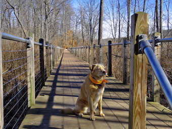 The trail was very dry without and water, ice or mud as we headed south and slightly uphill. The trail remained like this for about a mile as the sun got brighter and we warmed up. The trail was pretty well maintained through a sea of prickers and what look, at times, like Japanese knotweed. I let Sheila off her leash at some point as there were no other hikers on the trail. The small hills helped warm us up and I stopped to open up all the zippers I could on the hoody. Now that Sheila was off her leash and we were hitting a few hills I really missed my poles! After a mile we began to run into some water, mud and ice. Most of these place were easy to navigate without slipping or getting wet. At 1.4 miles we came to a small pond on the right of the trail. The pond was not marked on the map but we stopped so that I could take some pictures. There was a skim of ice on the pond which was formed by an obvious man-made dam. After taking my pictures, we got back on the trail and Sheila alerted as a woman was hiking toward us. I ushered Sheila off the trail and had her sit while the woman passed. At 1.6 miles a yellow trail appeared on the left and I knew this was the trail we needed to take to the swamp boardwalk. We turned and started walking downhill. After .25 miles we were at the beginning of the boardwalk where I stopped to take a few shots. The boardwalk was very impressive and the construction very sturdy. It included steel pipes to anchor it in the swamp, stainless steel cables between pipes, and a composite decking. As we were stopped for some shots, we heard a noise and looked up to see a biker approaching. I ushered Sheila to the side so the biker could pass and he said "Thank you" as he rode slowly passed us. We walked along the boardwalk stopping several times for me to take pictures until we reached the other end. My only regret was that we saw no critters. I knew we would come back during another season to see some wildlife. We continued walking on the trail and were surprised by another section of boardwalk. I took more pictures including some of a beaver or muskrat lodge. At the end of the boardwalk we found a dirt road so we walked it out to Maple Avenue where we turned right. We almost immediately turned left on the Buchanan Hill Trail which again started out downhill.
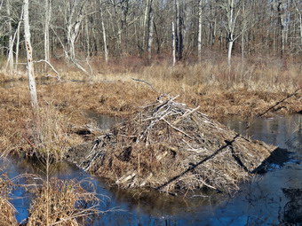 After a short distance we came to another small pond. I tried taking a few shots but the sun was at a really bad angle. We continued our walk passed the end of the pond and came to a fork in the trail. There was a single blue blaze on a tree in the middle of the fork which gave no indication of which way to go! I had studied the map and chose right and soon there was a blue blaze on a tree. The trail began to climb up a small hill and then descended down the other side. The descent was wet and muddy and the mud had been churned up by bikes. Within a short distance, the trail began the long but gentle climb up to the top of Buchanan Hill. The trail here was not as well maintained and had many briars across the path. From 2.9 miles to 3.4 miles we climbed 150 feet along a gentle 6% grade. Before we reached the summit plateau, I stopped to get some pictures of the mountains to the east on the other side of the Hudson. There was a haze present and it was hard to focus to get a good shot. This was another example of being there being better than any picture. There was a wide swathe cut through the tall grass and brush across the top of the hill and we just kept following it. The sun felt warm and it was really a beautiful day. The trail eventually entered the woods again but remained wide and easy to follow. After hiking another.7 miles, we were at Maple Avenue which was 4.1 miles into the hike. Cindy had already let me know she was tired so I reevaluated my planned route. Rather than walk a trail over to Ridge Road and then use a combination of trails and the road to return, Cindy wanted to simply walk north on Maple Avenue. I agreed that this was the shortest way to get back and maybe the easiest but I dreaded what I estimated would be a 2.5 miles walk on the road! Nonetheless, we turned right and started the road walk. Surprisingly, I was now missing my poles even more as my feet and legs were supplying all the power. I stopped a couple times and took pictures just to fight the boredom! I was beginning to get physically tired but my mental attitude was the big problem. With about .4 miles to go the road changed to pavement which Cindy appreciated but I loathed. Finally, at 2:25 PM we were back at the car after hiking 6.7 miles in 3 hours and 20 minutes with 30 minutes of stopped time. The elevation gain was 700 and our overall speed was 2 mph. The bikers who had been in the parking lot were gone replaced by horse trailers. Apparently, owning a horse allows you to park wherever you like including the exit to the parking area!
![]()
![]()
![]()
![]() On Monday, January 9th I wanted get out for a longer hike and decided to head for the Frick Pond area. An overnight ambulance call cut into my time for sleep again so I did not get up until 10:00 AM. I knew I still had time to get the hike in but I had to hurry. Sheila was already prepared to go as she really likes to hike. She was lying on the floor with her front legs spread barking up a storm. It was 35 degrees on the back porch as I started to get dressed. I put on my Mammut long-sleeved crew top with a long-sleeved baselayer. I wore a pair of Bauer First Ascent pants which are insulated against the cold and are bad slightly water repellant. I don't like the fot of these pants and have been looking for a replacement. I put on my Keen Durand hiking boots which fit well and are newer than what I have been wearing. I added a new pair of Xstance insoles in an effort to find the best support and cushioning for my feet. These insoles have shock absorbing gel pads, TPU arch support, and memory foam cushioning all wrapped in a breathable fabric. The insoles have been hyped by their manufacturer and have lived up to that hype. I almost always take my Leki poles with external locks as the internal twist locks sometimes fail. I put on a fleecy orange hat and took a pair of medium-weight gloves. I did don my Mammut hoody as it has enough zippers to dump heat if needed. I put my gear in the back and Sheila in the backseat and headed out the DeBruce Road at 11:00 AM. As I approached DeBruce the Ambulance pager went off for a call in Liberty to mutual aid Mobilemedic. I knew there was no other EMT available so I turned around and started to head back into Livingston Manor. Unfortunately, I had no cell service and could not call in to let anyone know I was coming. By the time I had cell service I could hear the control center canceling us as Mobilemedic had managed to free a crew. I was annoyed as I had changed my plans for no reason! I decided to go back to the house and hike on Round Top. At 11:30 AM I parked the car in the driveway and grabbed Sheila's leash from the car. We walked up the driveway and across the street to the parking lot at the Presbyterian Church. From there we headed to the back of the church to the cemetery hill. We began the ascent of the steepest hill behind the church and continued directly up the hill to the trailhead. The hill is short but gets the circulation pumping and is the steepest and longest climb on the "trail." My goal was to make it all the way up the hill without stopping which seemed easier on this day. At the top of the hill we stopped for minute so that I could observe the skies all around us. We turned left and entered the woods to begin our hike. The trailhead was damp with a layer a leaves and that continued as we entered the woods.
On Monday, January 9th I wanted get out for a longer hike and decided to head for the Frick Pond area. An overnight ambulance call cut into my time for sleep again so I did not get up until 10:00 AM. I knew I still had time to get the hike in but I had to hurry. Sheila was already prepared to go as she really likes to hike. She was lying on the floor with her front legs spread barking up a storm. It was 35 degrees on the back porch as I started to get dressed. I put on my Mammut long-sleeved crew top with a long-sleeved baselayer. I wore a pair of Bauer First Ascent pants which are insulated against the cold and are bad slightly water repellant. I don't like the fot of these pants and have been looking for a replacement. I put on my Keen Durand hiking boots which fit well and are newer than what I have been wearing. I added a new pair of Xstance insoles in an effort to find the best support and cushioning for my feet. These insoles have shock absorbing gel pads, TPU arch support, and memory foam cushioning all wrapped in a breathable fabric. The insoles have been hyped by their manufacturer and have lived up to that hype. I almost always take my Leki poles with external locks as the internal twist locks sometimes fail. I put on a fleecy orange hat and took a pair of medium-weight gloves. I did don my Mammut hoody as it has enough zippers to dump heat if needed. I put my gear in the back and Sheila in the backseat and headed out the DeBruce Road at 11:00 AM. As I approached DeBruce the Ambulance pager went off for a call in Liberty to mutual aid Mobilemedic. I knew there was no other EMT available so I turned around and started to head back into Livingston Manor. Unfortunately, I had no cell service and could not call in to let anyone know I was coming. By the time I had cell service I could hear the control center canceling us as Mobilemedic had managed to free a crew. I was annoyed as I had changed my plans for no reason! I decided to go back to the house and hike on Round Top. At 11:30 AM I parked the car in the driveway and grabbed Sheila's leash from the car. We walked up the driveway and across the street to the parking lot at the Presbyterian Church. From there we headed to the back of the church to the cemetery hill. We began the ascent of the steepest hill behind the church and continued directly up the hill to the trailhead. The hill is short but gets the circulation pumping and is the steepest and longest climb on the "trail." My goal was to make it all the way up the hill without stopping which seemed easier on this day. At the top of the hill we stopped for minute so that I could observe the skies all around us. We turned left and entered the woods to begin our hike. The trailhead was damp with a layer a leaves and that continued as we entered the woods.
Just before the first trail junction we passed the large tree that Brad and I had removed from the trail and it looked bigger than I remembered. At the first trail junction, I followed Sheila as she turned right and started up the woods road which has the gentler approach of the two. We continued up the trail and passing another rather larger tree I had cut by hand and removed from the trail. As we reached the end of the woods road, I looked to my left and saw that the tarps were still in place at the "cave" beneath the rock ledges. Someone had decided to create a camp/shelter/home hear on public and. I did not see anyone nor did I catch the smell of a fire. We turned left up the hill on the trail and continued to the first trail junction with the upper blue trail. We turned left and walked the yellow trail along the base of Round Top to the next junction with the blue trail. The trail was almost completely clear although I did pick up a few stray branches. When we reached the junction, I told Sheila "right" and she turned right on the blue trail and started to climb the hill. We turned right on the switchback in the blue trail which I had constructed to ease the erosion on the main trail and allow people to have a slightly more gentle climb. At the end of the switchback we turned right on the main blue trail and passed the white crossover trail on the way to the summit. We crossed over the summit and started down the blue rail on the other side. We again passed the white crossover trail continuing on to the yellow trail. We had not run into any blowdowns blocking the trail but we had removed a few small branches. We turned right and again walked along the yellow trail to the next junction with the blue trail. This time we turned left and headed down toward the lookout. The trail bed was clear with only a few small branches. When we reached the viewpoint, I took a look and I noticed that the view was very good without the leaves on the trees. We continued to follow the yellow trail as it descended steeply from the lookout to the first trail junction. We immediately turned around and started back up the yellow trail to the lookout. When the yellow trail turned right, we followed it back up through the dead ferns and passed the "sitting rock". At the first junction with the blue trail we turned right and followed the yellow trail along the base of Round Top. At the next junction with the blue trail, we turned left and headed up the hill toward the summit. At the white crossover trail, we turned left and walked along the trail so that I could check for branches and blowdowns. When we hit the blue trail, we turned left and then left immediately to stay on the blue trail. The switchback took us out into the woods and then back to the main blue trail where we turned left. We walked down the hill to the yellow trail where we turned left to walk along the base of Round Top. At the junction with the blue trail, we turned right and walked down the trail to the woods road. We turned right on the woods road that took us downhill to the first trail junction. There was still no activity at the shelter under the ledges. We turned left and walked out to the trailhead. We turned right and walked down the hill to the church parking lot. We crossed the parking lot and Rock Avenue to get to our driveway. When we arrived home, it was 12:40 PM and we had hiked just over 2 miles in an hour and 10 minutes.
![]()
![]()
![]()
![]() On Saturday, January 7th I had planned to go out for a longer hike but slept in to recover from 15 ambulance calls in 7 days! I stuck around the house for a while as there seemed to be a lot of emergency calls in the county. Cindy and I thought about going to someplace like Huggins Lake but I was worried about getting in to the parking area. I finally decided to go across the street to Round Top where I had not hiked for some time. The temperature was 37 degrees so I decided to venture out. I started to get ready at 12:45 PM with Sheila quitely watching my every move. I decided not to overdress as I often do as it seemed warm out except for the light breeze. I decided to put on my Mammut long-sleeved crew top with a long-sleeved baselayer. II wore a pair of RailRiders hiking pants which are expensive but last a long time and have features like deep pockets and a generous cut which I really like. It will soon be time to permanently switch to a pair of insulated pants. I decided to put on my Keen Durand hiking boots which fit well and are newer than what I have been wearing. I added a new pair of Xstance insoles in an effort to find the best support and cushioning for my feet. These insoles have shock absorbing gel pads, TPU arch support, and memory foam cushioning all wrapped in a breathable fabric. The insoles have been hyped by their manufacturer and have lived up to that hype. I almost always take my Leki poles with external locks as the internal twist locks sometimes fail. I put on a fleecy orange hat and took a pair of medium-weight gloves. I did don my Mammut hoody as it has enough zippers to dump heat if needed. At 1:10 PM we walked out the door to start the hike. I looked around and saw that the sky was overcast over Round Top but cloudier to the north and west. I grabbed Sheila's leash from the car and we walked up the driveway. We walked across the street and behind the Presbyterian Church.
On Saturday, January 7th I had planned to go out for a longer hike but slept in to recover from 15 ambulance calls in 7 days! I stuck around the house for a while as there seemed to be a lot of emergency calls in the county. Cindy and I thought about going to someplace like Huggins Lake but I was worried about getting in to the parking area. I finally decided to go across the street to Round Top where I had not hiked for some time. The temperature was 37 degrees so I decided to venture out. I started to get ready at 12:45 PM with Sheila quitely watching my every move. I decided not to overdress as I often do as it seemed warm out except for the light breeze. I decided to put on my Mammut long-sleeved crew top with a long-sleeved baselayer. II wore a pair of RailRiders hiking pants which are expensive but last a long time and have features like deep pockets and a generous cut which I really like. It will soon be time to permanently switch to a pair of insulated pants. I decided to put on my Keen Durand hiking boots which fit well and are newer than what I have been wearing. I added a new pair of Xstance insoles in an effort to find the best support and cushioning for my feet. These insoles have shock absorbing gel pads, TPU arch support, and memory foam cushioning all wrapped in a breathable fabric. The insoles have been hyped by their manufacturer and have lived up to that hype. I almost always take my Leki poles with external locks as the internal twist locks sometimes fail. I put on a fleecy orange hat and took a pair of medium-weight gloves. I did don my Mammut hoody as it has enough zippers to dump heat if needed. At 1:10 PM we walked out the door to start the hike. I looked around and saw that the sky was overcast over Round Top but cloudier to the north and west. I grabbed Sheila's leash from the car and we walked up the driveway. We walked across the street and behind the Presbyterian Church.
We began the ascent of the steepest hill behind the church and continued directly up the hill to the trailhead. The hill is short but gets the circulation pumping and is the steepest and longest climb on the "trail." My goal is always to make it all the way up the hill without stopping which was challenging as I have not been hiking as much as I would like and most of my hikes have been flat. As we neared the top of the hill, two women with a small dog exited the trailhead. The dog was not leashed and began to bark but the owner immediately put it on a leash. At the top of the hill we stopped for minute so that I could take a look at the skies and hills all around us. It looked like there was some snow coming over the hills but I looked Gina and it seemed to be fog. We turned left and entered the woods to begin our hike. The trailhead was a little wet but was free from snow and this continued as we entered the woods. There was a thick layer of wet leaves on the ground. As we entered the woods, snow began to fall as frozen white pellets Just before but this did not last very long. There was a large branch hanging down into the trail but I was able to give it a good pull to dislodge it and pull it off the trail. Just before the first trail junction, we came to the spot where a large tree had fallen across the trail. I had cut one end of the tree with my ax and saw. Brad and I had finished the job when he was staying for Thanksgiving. It was almost 2 feet in diameter and we had to cut it several times to move it off the trail. At the first trail junction, I followed Sheila as she continued straight ahead up the hill toward the lookout. When we reached the top of the trail, I stopped to take a look from the viewpoint. The snow had almost stopped but it was still coming down! We followed the yellow trail as it headed uphill toward the next trail junction. The woods attested to the fact that winter had arrived even though the snow had melted. We passed the "sitting rock" and continued on the yellow trail to the first junction with the blue trail. At the junction we turned right and walked the yellow trail along the base of Round Top to the next junction with the blue trail. I noticed that one of the rock overhangs below the ledges now had several tarps and I thought I could see smoke. I made a note to report this to the Town of Rockland. We turned left on the blue trail and started up the hill. We bypassed the white crossover trail and continued on the blue trail across the summit of Round Top. There were many small branches to clear and a few larger ones on the summit. Fortunately, I was able to remove them all without tools. As we began down the other side, we bypassed the white crossover trail and turned left on the switchback in the blue trail. We continued following the switchback as it took us out into the woods and then turned almost 180 degrees to bring us back to the main blue trail. We turned left and continued downhill on the blue trail. We followed the blue trail to the yellow trail. We turned left and walked on the yellow trail along the base of Round Top to the junction with the blue trail.
This time we turned right and walked down the yellow trail to the woods road. We walked along the woods road toward the first trail junction. I could smell a distinct odor coming from the direction of the "shelter" that someone had constructed. Just before the first trail junction, I looked at the remains of the large blowdown I had cut and removed from the trail. Just passed this were the remains of a smaller blowdown I had cut up. This tree had hung over the trail for months but finally came down in the wind. We turned around at the first trail junction and started back up the woods road. We turned left when the yellow trail started up toward the first junction with the blue trail. We turned left and walked the yellow trail to the next junction with the blue trail. At the next trail junction we turned right on the blue trail and started up the hill. We turned right on the switchback and followed it out and back to the main blue trail. We almost immediately turned right on the white crossover trail and followed it along the shoulder of Round Top to the blue trail on the other side. I wanted to make sure there were no blowdowns blocking the trail. We turned right and walked down the other side to the junction with the yellow trail. At the junction with the yellow trail we turned right and again walked along the base of Round Top to the next junction with the blue trail. This time we turned left and continued on the yellow trail passing the "Sitting Rock" to the viewpoint. At the viewpoint we turned left and walked down the steep trail to the first trail junction. This time we continued out to the trailhead. There was a large SUV parked by the trailhead with its engine running. At the trailhead we turned right and walked down the hill to the church parking lot. We crossed the parking lot and Rock Avenue to get to our driveway. When we arrived home, it was 2:20 PM and we had hiked a little more than 2 miles in an hour and 20 minutes including some trail maintenance.
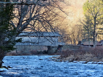
![]()
![]()
![]()
![]()
![]() On Monday, January 2nd, I wanted to get in a hike with Cindy on the second day of the year. Cindy likes short, flat hikes so I chose to go to the Beaverkill Campgrounds to hike along the river. The campground is closed for the winter and I thought it would be quiet. I also hoped the recent rains and snow melt would have swollen the stream to provide some interest. I also knew the route might have some packed snow and ice but was usually not too muddy or wet. We started to get ready at 2:15 PM with the temperature at 50 degrees. Sheila certainly was happy to go hiking two days in a row. I put on my Mammut long-sleeved crew top but decided not to wear a baselayer. I wore a pair of RailRiders hiking pants which are expensive but last a long time and have features like deep pockets and a generous cut which I really like. It will soon be time to permanently switch to a pair of insulated pants. I decided to put on my Keen Durand hiking boots which fit well and are newer than what I have been wearing. I added a new pair of Xstance insoles in an effort to find the best support and cushioning for my feet. These insoles have shock absorbing gel pads, TPU arch support, and memory foam cushioning all wrapped in a breathable fabric. The insoles have been hyped by their manufacturer and have lived up to that hype. I took my Leki poles with external locks as the internal twist locks sometimes fail. I wore a light hat, packed a pair of gloves, and put on my OR Crocodile gaiters because of the possibility of water and mud. I also donned my Mammut hoody which has enough zippers to dump heat when it is needed. We left the house at 2:45 PM as I drove out Old Route 17 toward Roscoe and turned right on Beaverkill Road. As we started the descent into the Beaverkill Valley, I turned left on Campsite Road and followed it down to the parking area near the Beaverkill Covered Bridge. There were no cars parked in the lot. A glance at the river showed that the level was very high leaving almost no "beach" by the covered bridge. I put Sheila on her leash and shouldered my pack as we began our hike.
On Monday, January 2nd, I wanted to get in a hike with Cindy on the second day of the year. Cindy likes short, flat hikes so I chose to go to the Beaverkill Campgrounds to hike along the river. The campground is closed for the winter and I thought it would be quiet. I also hoped the recent rains and snow melt would have swollen the stream to provide some interest. I also knew the route might have some packed snow and ice but was usually not too muddy or wet. We started to get ready at 2:15 PM with the temperature at 50 degrees. Sheila certainly was happy to go hiking two days in a row. I put on my Mammut long-sleeved crew top but decided not to wear a baselayer. I wore a pair of RailRiders hiking pants which are expensive but last a long time and have features like deep pockets and a generous cut which I really like. It will soon be time to permanently switch to a pair of insulated pants. I decided to put on my Keen Durand hiking boots which fit well and are newer than what I have been wearing. I added a new pair of Xstance insoles in an effort to find the best support and cushioning for my feet. These insoles have shock absorbing gel pads, TPU arch support, and memory foam cushioning all wrapped in a breathable fabric. The insoles have been hyped by their manufacturer and have lived up to that hype. I took my Leki poles with external locks as the internal twist locks sometimes fail. I wore a light hat, packed a pair of gloves, and put on my OR Crocodile gaiters because of the possibility of water and mud. I also donned my Mammut hoody which has enough zippers to dump heat when it is needed. We left the house at 2:45 PM as I drove out Old Route 17 toward Roscoe and turned right on Beaverkill Road. As we started the descent into the Beaverkill Valley, I turned left on Campsite Road and followed it down to the parking area near the Beaverkill Covered Bridge. There were no cars parked in the lot. A glance at the river showed that the level was very high leaving almost no "beach" by the covered bridge. I put Sheila on her leash and shouldered my pack as we began our hike.
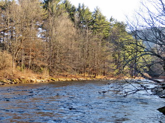 We started out at 3:00 PM by walking out of the parking lot to the bridge with the temperature at 52 degrees. The skies were completely overcast. When we got to the other side, the gate just off the road was closed as the campgrounds had closed September 5. I looked at the trail and saw that it had some packed snow and ice but there were also some spots that were clear. We turned left on a woods road that parallels the river and started down a short hill. We were able to work our way around the ice and packed snow. We passed the spring house and continued on the deserted woods road. We came to an area with a little path down to the river. Just passed this area the trail had been eroding due to the water running down the bank. The DEC had replaced a culvert pipe and installed a second. They had also brought in fill and packed it to reconstruct the path. I found this interesting as the campsites along this path are no longer used and are abandoned. I walked down to the edge of the river very carefully as the rocks were slippery and the water looked deep and cold. I took some pictures downstream and some upstream to the bridge. The light downstream was interesting as the sun was starting to go down in the west. The view of the bridge was almost blocked by the angle I had. When I was done photographing, we got back on the trail and passed several areas with unused picnic tables. The state had plowed the road for reasons I do not understand. Several picnic tables sat unused and rotting along the road, a testimony to better days. We walked by these tables which had not been used in many years. A little later we came to what was once a bathroom for some campsites that had long since disappeared.Further along on the road, there was another area with more picnic tables. There was a path over to the river so I walked over and found the water was sparkling in the sun and was very clear. I took some pictures of the sun reflecting off the water both upstream and downstream.
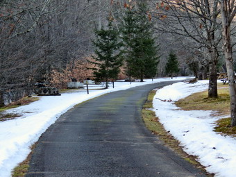 We continue on and at about .7 miles the woods road met the paved road that serves the campsites. We continued on the road through the campsites and along the river. The campsites were all empty and I took pictures of the solitude. The road through the campsite was plowed and there was still some snow covering the ground despite the warm weather and rain. We walked to the last campsite where the road ends and Sheila and I walked down to the edge of the river. I was careful to watch where I was walking as the water was a little high and looked cold. Sheila didn't seem to think the water was too cold as she jumped in to wade. I stopped to take some pictures of the river especially downstream. We continued along the shore a little further passed the last campsite and I took some more shots before walking up to the campsite and back to where Cindy was standing. I stowed my camera and picked up the pack. We walked back from the last campsite, staying to the left of the last bathroom to walk back on the other paved road through the campsites. This road parallels the one we walked out on to make a sort of loop. I stopped to take pictures of the road lined by the remains of some pine trees that had been cut down. I also took some shots of the volleyball net stretched between two posts with a "court" of snow. We retuned the way we had come although at a quicker pace. As we approached the bridge, I saw that there were still no cars in the lot. We walked through the bridge and turned right to go back to the car. Cindy got in the car but Sheila and I walked down to the stream. The water was very high and I had to walk downstream a little to get to the big rock that juts out into the stream. The sun was getting low in the sky but I was able to take some pictures downstream. I turned around and took multiple picture of the bridge and the abutments. I walked back to the car at 4:25 PM having hiked 2.5 miles in 1 hour and 25 minutes. The car's thermometer show the temperature had dropped to 43 degrees as the sun was now completely down behind the trees.
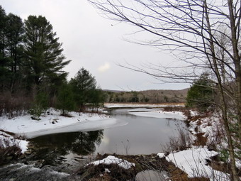
![]()
![]()
![]()
![]()
![]() On Sunday, January 1st I returned from church at 12:30 PM to find a text from Lisa Lyons who had organized a First Day Hike sponsored by the DEC. The hike was the 2.2 miles around Frick Pond and started at 2:00 PM. I was not excited about the short length on a trail that I knew would be wet but decided it was a good way to start the New Year. I started to get ready at 1:15 PM with the temperature at 39 degrees on the back porch. I knew that the trail could have some snow covering with ice but suspected there would be some open water and plenty of mud. I put on my Mammut long-sleeved crew top with a long sleeved baselayer. I wore a pair of RailRiders hiking pants which are expensive but last a long time and have features like deep pockets and a generous cut which I really like. I decided to put on my old Salomon B52 boots which have lasted many seasons but still fit well. I paired these shoes with an old pair of Dahlgren alpaca wool socks as the insulation in the B52s is not what it used to be. These boots had the original insole in them and it is not very supportive for my arch. I solved the problem by putting in a pair of Protalus insoles which offer good support with a low profile. I took my Leki poles with external locks as the internal twist locks sometimes fail. I wore a light hat and a pair of light gloves. I also packed a pair of heavier gloves in case they became necessary. I also donned my Mammut hoody which has enough zippers to dump heat when it is needed. I put on my OR Crocodile gaiters to fend off the water and mud. I had my Silky Sugowaza saw in my pack in case I needed to do any trail work. I put my gear in the back and Sheila in the backseat and headed out the DeBruce Road at 1:40 PM. After 6 miles, at Mongaup Pond Road, I turned left and continued to follow the road bearing left onto Beech Mountain Road at the fork. When we arrived in the parking areas both were almost filled with cars and trucks. I pulled into the larger lot next to Lisa's car and made sure other cars could get out of the lot. Sheila was acting as if she hadn't hiked in a month as she tried to get out of the car and ran around. The temperature was 38 degrees and the skies were overcast with a few blue spots. I put Sheila on her leash and joined the group in front of the map for the Frick Pond area. I knew several of the people standing around and we greeted each other. Lisa was explaining the route for the hike and offered to lend some of the almost 20 people hiking poles. I was beginning to get cold as I was dressed to hike not stand around. Sheila and I headed out the woods road that leads to the Quick Lake Trail. When we got to the register, there were still no hikers in sight so I turned left to walk the Quick Lake Trail back toward the parking area. In a few minutes people started hiking toward us so I turned around and hiked back toward the register.
On Sunday, January 1st I returned from church at 12:30 PM to find a text from Lisa Lyons who had organized a First Day Hike sponsored by the DEC. The hike was the 2.2 miles around Frick Pond and started at 2:00 PM. I was not excited about the short length on a trail that I knew would be wet but decided it was a good way to start the New Year. I started to get ready at 1:15 PM with the temperature at 39 degrees on the back porch. I knew that the trail could have some snow covering with ice but suspected there would be some open water and plenty of mud. I put on my Mammut long-sleeved crew top with a long sleeved baselayer. I wore a pair of RailRiders hiking pants which are expensive but last a long time and have features like deep pockets and a generous cut which I really like. I decided to put on my old Salomon B52 boots which have lasted many seasons but still fit well. I paired these shoes with an old pair of Dahlgren alpaca wool socks as the insulation in the B52s is not what it used to be. These boots had the original insole in them and it is not very supportive for my arch. I solved the problem by putting in a pair of Protalus insoles which offer good support with a low profile. I took my Leki poles with external locks as the internal twist locks sometimes fail. I wore a light hat and a pair of light gloves. I also packed a pair of heavier gloves in case they became necessary. I also donned my Mammut hoody which has enough zippers to dump heat when it is needed. I put on my OR Crocodile gaiters to fend off the water and mud. I had my Silky Sugowaza saw in my pack in case I needed to do any trail work. I put my gear in the back and Sheila in the backseat and headed out the DeBruce Road at 1:40 PM. After 6 miles, at Mongaup Pond Road, I turned left and continued to follow the road bearing left onto Beech Mountain Road at the fork. When we arrived in the parking areas both were almost filled with cars and trucks. I pulled into the larger lot next to Lisa's car and made sure other cars could get out of the lot. Sheila was acting as if she hadn't hiked in a month as she tried to get out of the car and ran around. The temperature was 38 degrees and the skies were overcast with a few blue spots. I put Sheila on her leash and joined the group in front of the map for the Frick Pond area. I knew several of the people standing around and we greeted each other. Lisa was explaining the route for the hike and offered to lend some of the almost 20 people hiking poles. I was beginning to get cold as I was dressed to hike not stand around. Sheila and I headed out the woods road that leads to the Quick Lake Trail. When we got to the register, there were still no hikers in sight so I turned left to walk the Quick Lake Trail back toward the parking area. In a few minutes people started hiking toward us so I turned around and hiked back toward the register.
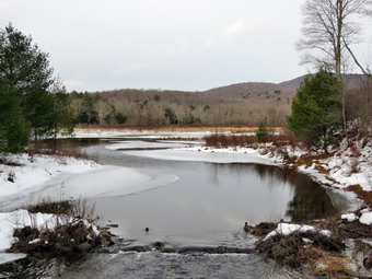 At the register we turned left and started toward Frick Pond on the woods road. The woods road was wet and muddy with patches of frozen snow and ice. I removed a few branches and pushed some away from the trail. I also used my poles to clear some of the leaves out of the small streams that crossed the trail. As we approached Gravestone Junction, I stopped to remove a larger branch and to cut down a small tree that was hanging in the trail. We continued along the trail and I checked that the Lobdell Memorial was still standing. At Gravestone Junction we stayed to the left to follow the Quick Lake Trail down to the bridge at the outlet end of Frick Pond. Sheila and I were passed by a few people as we cleared some branches but passed some people as we were setting a fast pace. We stopped at the bridge and I decided to take a few shots even though the skies were overcast. We continued across the bridge and around the pond crossing the muddy spot where our crew had done some work to improve drainage. I noticed that the two bridges on the west side of the pond needed some repair work before they have to be replaced. At the junction with the Big Rock Trail, we turned right on the Big Rock Trail and continued along the west side of the wetlands at the head of the pond. I was trying to pass a few people as I was concerned that some hikers might not be aware of how slippery the wooden walkways can be. The wooden walkways can the very slippery when wet even when there is no ice. These walkways also need repair, a fact we have mentioned to both the DEC and the NYNJTC. Repairing them now will be much easier than replacing them later!
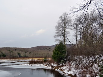 We walked with some other people through the spruce tunnel and across two bridges. I looked to see if there were some photographic opportunities but decided to move on. The north end of the pond was very wet and muddy. We came to a large blowdown across the trail which I had not been able to clear. I decided to cut off a few branches to make it easier for hikers to get over the larger trunk. I took out my saw and began to cut off branches and throw them in a pile. I cut as much as I could and then hiked around the blowdown to meet some other people at Times Square. We turned right to complete the loop around Frick Pond on the Logger's Loop. This trail is a very gentle climb and then a slight descent to Gravestone Junction to complete the loop. This trail had nothing much to remove but it was very wet and muddy. We continue along the trail and came to two small trees hanging into the trail by the primitive campsites. I got out my saw and cut both trees and removing them from the trail. A few people passed us as I was doing the work. I was concerned that a few of the people at the end of the hike had not yet caught up to me. Sheila and I turned around and started to walk back toward Times Square. We soon met the others hiking toward us and turned around to hike with tem back to the parking area. We were soon back at Gravestone Junction where we turned left. I explained the significance of the memorial marker. We walked the Quick Lake Trail back to the trail register. We turned right to stay on the Quick Lake Trail to the large lot where my car was parked. It was 3:45 PM and we had hiked the 2.4 miles in 1 hour and 35 minutes with an elevation gain of 200 feet. Lisa had a few gifts for each f us and we toasted the New Year.
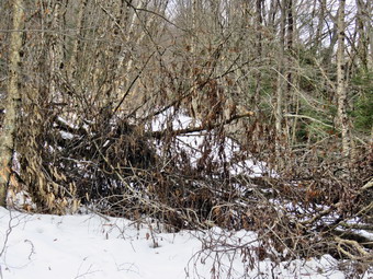
![]()
![]()
![]()
![]()
![]() On Wednesday, December 28th I wanted to get out on another hike with my son-in-law Brad. I had mentioned trimming some trees on the Parksville Rail Trail and he said he thought that would be a good idea. Brad is a monster with the ax and can manhandle even the largest pieces of trees off the trail. We planned to get an early start but the ambulance pager went off sending us to a call north of Roscoe. I was familiar with the patient and knew she would want to go to Garnet Health in Middletown. By the time we returned it was noon and Brad needed to get some lunch. Sheila was excited about hiking two days in a row and she showed it as we were getting dressed! It was 35 degrees when we started to get ready at 1:00 PM and the skies were overcast with a slight breeze. I put on my Mammut long-sleeved crew top with a long sleeved baselayer. I wore a pair of RailRiders hiking pants which are expensive but last a long time and have features like deep pockets and a generous cut which I really like. It will soon be time to permanently switch to a pair of insulated pants. I decided to put on my old Salomon B52 boots which have lasted many seasons but still fit well. I paired these shoes with an old pair of Dahlgren alpaca wool socks as the insulation in the B52s is not what it used to be. These boots had the original insole in them and it is not very supportive for my arch. I solved the problem by putting in a pair of Protalus insoles which offer good support with a low profile. I took my Leki poles with external locks as the internal twist locks sometimes fail. I wore a light hat and a pair of light gloves. I also packed a pair of heavier gloves in case they became necessary. I also donned my Mammut hoody which has enough zippers to dump heat when it is needed. I put my Silky Sugowaza saw in my pack and asked Bard to carry the Friskars pack ax. At 1:15 PM we put my gear in the car and Sheila in the back seat. I headed out Old Route 17 and drove across the Flats. I took Old Route 17 and Service Road to the point where they meet Fox Mountain Road. There were no cars in the parking lot when we started out on the trail at 1:35 PM.
On Wednesday, December 28th I wanted to get out on another hike with my son-in-law Brad. I had mentioned trimming some trees on the Parksville Rail Trail and he said he thought that would be a good idea. Brad is a monster with the ax and can manhandle even the largest pieces of trees off the trail. We planned to get an early start but the ambulance pager went off sending us to a call north of Roscoe. I was familiar with the patient and knew she would want to go to Garnet Health in Middletown. By the time we returned it was noon and Brad needed to get some lunch. Sheila was excited about hiking two days in a row and she showed it as we were getting dressed! It was 35 degrees when we started to get ready at 1:00 PM and the skies were overcast with a slight breeze. I put on my Mammut long-sleeved crew top with a long sleeved baselayer. I wore a pair of RailRiders hiking pants which are expensive but last a long time and have features like deep pockets and a generous cut which I really like. It will soon be time to permanently switch to a pair of insulated pants. I decided to put on my old Salomon B52 boots which have lasted many seasons but still fit well. I paired these shoes with an old pair of Dahlgren alpaca wool socks as the insulation in the B52s is not what it used to be. These boots had the original insole in them and it is not very supportive for my arch. I solved the problem by putting in a pair of Protalus insoles which offer good support with a low profile. I took my Leki poles with external locks as the internal twist locks sometimes fail. I wore a light hat and a pair of light gloves. I also packed a pair of heavier gloves in case they became necessary. I also donned my Mammut hoody which has enough zippers to dump heat when it is needed. I put my Silky Sugowaza saw in my pack and asked Bard to carry the Friskars pack ax. At 1:15 PM we put my gear in the car and Sheila in the back seat. I headed out Old Route 17 and drove across the Flats. I took Old Route 17 and Service Road to the point where they meet Fox Mountain Road. There were no cars in the parking lot when we started out on the trail at 1:35 PM.
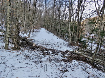 I put Sheila on her leash as we headed out to the road and under the Quickway on Fox Mountain Road. We crossed the bridge over the Little Beaverkill and then turned right to step over the guard rail. There is a definite trail on the right which passes by the trestle supports that carried the trail tracks over the stream. The emblem on the trestle is faint but shows the #28 of Davey Allison and the Texaco Havoline star. We walked up the trail to the top of the trestle. As we entered the shade of the trees, it seemed a little cooler and I was concerned I might be too cold as I had not worn insulated pants. The trail was well defined and stretched ahead for some distance. Like most rail trails it was very straight. Town of Liberty Supervisor Frank DeMayo had told me that this was state land and the town had an agreement from the state to use it. The hope is to connect the Parksville Rail Trail to all the sections that stretch as far as Livingston Manor. We started to walk along the trail and noticed there was quite a bit of traffic on the Quickway! The land dropped off steeply to the Little Beaverkill on the right. On the left were some "cliffs" which were the result of the railroad cutting a path for the tracks. The trail was covered in 2 or 3 inches of frozen snow and we could see no human tracks. We were breaking through the snow which made the walking more difficult but snowshoes would have been overkill. We continued to walk along the well-defined trail. It was a pleasant walk and we picked up small branches along the way. There are two places along the trail where there were piles of garbage. It is hard to determine why they are there. Both piles had tarps over them which seemed to indicate someone once valued the items. Over the bank on the left near the first pile is the remains of a VW bug.
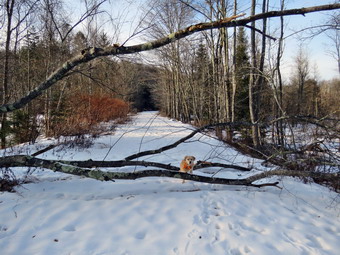 We came to the large blowdown across the trail which we wanted to clear from the trail so that people could more easily walk the trail without finding a way around the blockage. I took some "before" pictures and then we started to work on the bushy blowdown. A large tree had come down taking smaller ones with it causing a real mess. I grabbed the saw and started to clear the many small branches on the near side of the blowdown. Brad took the ax and began to cut some of the larger branches from the other side. The work went rather quickly with Brad chopping away much of the pile. Soon we were left with the larger trunk and a few big branches. Brad cut the largest one near the top and then turned his attentions to the big trunk near the base. I used the saw to cut some of the larger branches near the top. I dragged these out of the way as Brad finished the cut through the trunk. We were able to pivot a very large piece of trunk off the trail. We cleaned up a few stray branches and I took some "after" shots. We picked up our packs and continued on the trail. We came to two more smaller trunks across the trail and quickly removed them. We soon came to a gate on the trail which was odd since it was state land. No one seems to know why the gate is there or who placed it. We walked around the gate and continued on the trail. The snow depth here increased to about 6 inches. The snow was softer as this area is exposed to the sun and kit was like walking through sand. Soon we came to a small pond on the right with a red building behind it. The building looked to be in good shape but the windows were all boarded up. The sun was low in the sky giving the pond and building some interesting lighting. The pond was completely frozen over and we could no longer see the beaver slide across the trail. I took some pictures of the pond and the building before continuing on the trail. We came to another blowdown which was easy to walk through but which I wanted to clear.
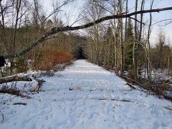 I again took some "before" pictures and then we got to work using much the same method we had used on the other blowdown. This one had far fewer small branches. Brad began to use the ax to cut the thicker part of the trunk near the roots. I used the saw to cut the tops of the trees off. I then made a couple of cuts to create some sections that were easy to remove. Brad and I removed the two larger sections and we were done. I took some "after" shots and then we picked up our gear and continued on the trail. In a short distance we came to a driveway on the left which leads to the Sonoma Falls property. I knew this was private land but two town supervisors had said it was alright to visit it. On this day I decided I wanted to show Brad the buildings that remained. I also wanted to inspect the first falls from behind the main building as I thought it might be frozen. We walked passed the buildings to a viewpoint that let us see the first and second falls farther upstream. Like the falls in the other direction the day before, these were also frozen and very beautiful. I took pictures of the owed falls and the pool in front of. I zoomed out to capture some shots of the second falls and some of both falls in one picture. I also took some shots of the water flowing down the stream under the ice and then decided to shoot a short video. I finished by snapping some pictures of the blue sky and the old cider mill. We decided we were tired and it was getting late so we started back at 3:0f PM setting a quick pace for the conditions. We kept the pace quick but it seemed to me the trail went on forever even though we did not stop. For the 1.6 miles back we averaged well over 2 mph. Hiking with Brad is always fun as we have similar interests and talking makes the walking go faster. We were back at the car at 3:35 PM having hiked 2.6 miles in 2 hours including the time to remove the blowdowns and photograph the falls. I checked my phone and there had been no ambulance calls!
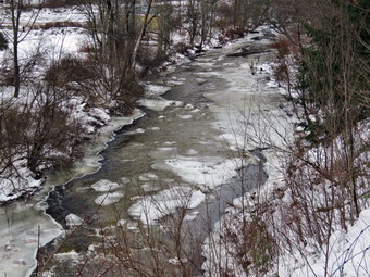
![]()
![]()
![]()
![]()
![]() On Tuesday, December 27th I wanted to get out for my first winter hike after more than two weeks without hiking. Between the weather, a severe cold, planning for Christmas church services and a large number of ambulance calls I had been inside far too long. My son-in-law Brad was at the house and I knew he would go with me. We had planned to hike in the morning but an ambulance all interfered with those plans. We finally started to get ready at 2:00 PM and I knew it would have to be a short hike. I thought this was a good idea anyway as I needed to build myself back up and we still needed to be around for ambulance calls. I decided we would go to the Parksville Rail Trail and hike from Fox Mountain Road to Parksville and back. The hike is less than 3 miles but I was hoping the falls would be frozen and that I could get some shots. Sheila could not contain her excitement as we were getting dressed as if she thought we might not hike again! It was 25 degrees when we started to get ready at 2:00 PM and the skies were overcast with a slight breeze. I knew that the trail would be snow covered and frozen but suspected there might be some open water and mud. I put on my Mammut long-sleeved crew top with a long sleeved baselayer. I wore a pair of Bauer First Ascent pants which are insulated against the cold bad slightly water repellant. I decided to put on my old Salomon B52 boots which have lasted many seasons but still fit well. I paired these shoes with a heavy pair of Teko wool socks as the insulation in the B52s is not what it used to be. The other problem with these boots is that they have the original insole in them and it is not very supportive for my arch. I took my Leki poles with external locks as the internal twist locks sometimes fail. I wore a heavier fleece hat and a pair of light gloves. I also packed a pair of heavier gloves in case they became necessary. I also donned my Mammut hoody which has enough zippers to dump heat when it is needed. At 1:20 PM we put my gear in the car and Sheila in the back seat. I headed out Old Route 17 and drove across the Flats. I took Old Route 17 and Service Road to the point where they meet Fox Mountain Road. There was one car in the parking lot when we started out on the trail at 2:35 PM.
On Tuesday, December 27th I wanted to get out for my first winter hike after more than two weeks without hiking. Between the weather, a severe cold, planning for Christmas church services and a large number of ambulance calls I had been inside far too long. My son-in-law Brad was at the house and I knew he would go with me. We had planned to hike in the morning but an ambulance all interfered with those plans. We finally started to get ready at 2:00 PM and I knew it would have to be a short hike. I thought this was a good idea anyway as I needed to build myself back up and we still needed to be around for ambulance calls. I decided we would go to the Parksville Rail Trail and hike from Fox Mountain Road to Parksville and back. The hike is less than 3 miles but I was hoping the falls would be frozen and that I could get some shots. Sheila could not contain her excitement as we were getting dressed as if she thought we might not hike again! It was 25 degrees when we started to get ready at 2:00 PM and the skies were overcast with a slight breeze. I knew that the trail would be snow covered and frozen but suspected there might be some open water and mud. I put on my Mammut long-sleeved crew top with a long sleeved baselayer. I wore a pair of Bauer First Ascent pants which are insulated against the cold bad slightly water repellant. I decided to put on my old Salomon B52 boots which have lasted many seasons but still fit well. I paired these shoes with a heavy pair of Teko wool socks as the insulation in the B52s is not what it used to be. The other problem with these boots is that they have the original insole in them and it is not very supportive for my arch. I took my Leki poles with external locks as the internal twist locks sometimes fail. I wore a heavier fleece hat and a pair of light gloves. I also packed a pair of heavier gloves in case they became necessary. I also donned my Mammut hoody which has enough zippers to dump heat when it is needed. At 1:20 PM we put my gear in the car and Sheila in the back seat. I headed out Old Route 17 and drove across the Flats. I took Old Route 17 and Service Road to the point where they meet Fox Mountain Road. There was one car in the parking lot when we started out on the trail at 2:35 PM.
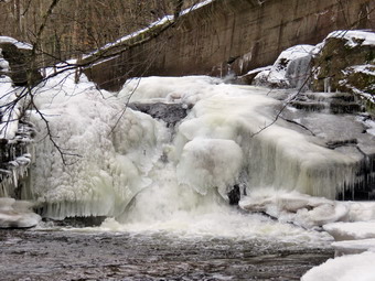 I did not bring my GPS unit as we had hiked the trail so many times before. We had both brought spikes in case they became necessary but had opted not to bother with snowshoes as I did not think they would be necessary The open trail just before the woods was covered in frozen snow and the breeze made it feel even cooler. The frozen snow had been rutted by people who did not wear snowshoes and had frozen that way. Fortunately, there wasn't much snow and the rough surface was manageable. We entered the trees which blocked the breeze. There was no sun to mention so we did not feel colder because we were in the "shade". We immediately encountered some open water, mud and frozen mud. Shortly after this, a large dog came trotting down the trail with no leash and no owner in sight. The dog walked right up to us and began sniffing Sheila who I had on her leash. Sheila did not appreciate the attention but the dog would not back away. We continued to walk on the trail with the dog following behind until we saw a man walking toward us. As we passed we exchanged greetings. I watched as the man caught up to the dog and it seemed like they were together. One look down to the Little Beaverkill showed the stream volume was high from the recent rain. I wondered about the condition of the falls and whether they would be frozen or not. Sheila was taking her own route and following her nose. We were trying to hike quickly but the rough snow and patches of ice were slowing us down. Depending on the ice and snow we were often crossing from one side of the trail to the other to get the best grip. We were soon at the wooden walkways where we stopped so I could take some pictures of the river below. The river had some large expanses of ice and looked very cold. The sky was almost completely overcast. I took some shots of the rivers, the Thailand the walkways before we continued over the walkways. The wooden surface was covered in a thin layer ice with snow over the top making the footing slippery. Beyond the far end of the bridge was some running water and some ice. The problem is that a rock slide has blocked the culvert under the small bridge causing water, mud and stones to be diverted over the walkway. Unblocking the culvert and covering the walkways with some screening would help. We continued on the trail and found a few blowdowns that should be cleared. As we approached the falls, we could hear the sound of the falls roaring.
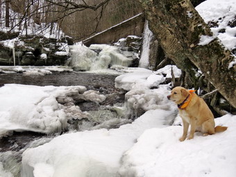 When we arrived at the falls, we found that there was a large mass of ice where the falls had frozen but there was a high volume of very clear and cold water under the ice. I looked at the path down to the base of the falls and found it covered in snow on top of ice. I decided to work my way down the path with my poles in my hands and my pack on my back. I was able to dig in my heels and make it down the path to the water's edge. All but the last few feet was pretty easy. I put down my pack and poles and got out my camera. On some previous trips I was able to walk out onto rocks that were usually covered with water. On this trip these rocks were covered with water leaving a small strip of dry land along the edge of the stream. I took some shots downstream where there were ice shelves with water running beneath them. I then the turned my attention to the falls. I took numerous pictures of the area in front of falls and the falls themselves. The water was rolling over the rocks and under the ice. Sheila posed my sitting on the ground for a few shots. After this, she picked her way or some icy rocks to an area of snow where she sat with the falls in the background. I took some shots before shouldering my pack and starting back up to the trail. Working my way up the bank proved much harder than getting down but I made it with the help of my poles. Sheila, of course, was already up on the trail looking down at me. I took some more shots of the falls from above near the picnic bench and a few of the area upstream. We continued the hike on the trail but walked by the bench where a path leads down to the stream. This area was not that interesting and I just wanted to walk. The trail continued to be covered in frozen snow with large patches of ice frozen solid. We set a quick pace for the rest of the hike toward the Parksville end of the trail. Just after the gate at that end, we stopped at the sign which outlines the milk that the O&W transported. The sign also mentions the large number of hotels that had been in the area. I pointed out some of the more interesting facts to Brad after wiping off a layer of snow. We turned around and headed back to the car. I knew I would not be taking any more pictures and we set a rapid return pace. Brad and I continued back to the car without meeting any other people. We were back at the car at 4:00 PM after hiking 2.8 miles in 1 hour and 35 minutes including the stopped time for pictures. There is virtually no elevation gain on the hike except the short trips down to the streambed. Brad and I headed home. We found we had missed one call that was covered by one of our crews. We were only home for a few minutes until the pager sounded again and we were off on a call.