
What You Missed
Spring 2023
Spring 2023
![]()
![]()
![]()
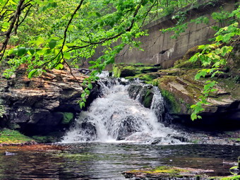
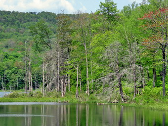
![]() On Thursday, June 15th Sheila and I had returned home from hiking the Parksville rail trail. The skies were no darker than they had been but the breeze had picked up. I thought for a few moments and the decided to go across the street the hike on Round Top. I had grabbed Sheila's leash from my trunk and we walked up the driveway at 2:50 PM. We walked across the street and to the parking lot of the Presbyterian Church. We walked behind the church to get to the road up the hill to the trailhead. We began the ascent of the steepest hill behind the church. The hill is short but gets the circulation pumping and is the steepest and longest climb on the "trail." My goal is always to make it all the way up the hill without stopping which I was able to do by picking the right pace. I was surprised that it seemed easier to hike the hill after already completing 2.5 miles. I am having some trouble founding the right pair of hiking boots that allow me to insert the insoles I like and still fit me feet! At the top of the hill we turned left and entered the woods to begin our hike. The trail was dry and there were no wet spots or muddy places to make it slippery. At the first trail junction, we followed Sheila as she continued straight ahead up the hill toward the lookout. The trail was well-worn as this is the most popular part of the hike. Some people simply hike up to the lookout over town and then back down. When we reached the top of the trail, we walked off the trail to the left to the upper viewpoint. The views down into town and across the valley to the hills were beautiful but the leaves on the trees block some areas. After taking in the view, we followed the yellow trail as it headed uphill toward the next trail junction. As we walked, I removed a few loose branches from the trail. We passed the "sitting rock" and continued on the yellow trail to the first junction with the blue trail. At the junction we turned right and walked on the yellow trail along the base of Round Top. I made note that there were a few branches that were leaning into the trail and needed to be lopped. At the next junction with the blue trail, we turned left and started up toward the summit. Almost immediately we came to a large branch or a small tree that was partly blocking the trail. I tried to remove it but found I would have to come back with a saw. Everything was very green and there were a few branches encroaching on the trail. We bypassed the white crossover trail and walked over the summit to start down the other side. We again bypassed the white crossover trail but turned left on the switchback in the blue trail. The switchback took us out into the woods before turning almost 180 degrees to take us back to the main blue trail. We turned left and walked downhill to the yellow trail where we turned left. We again walked along the base of Round Top on the yellow trail. This time when we reached the trail junction we turned right to head down the trail to the woods road. We continued to follow the yellow blazes back to the first trail junction.
On Thursday, June 15th Sheila and I had returned home from hiking the Parksville rail trail. The skies were no darker than they had been but the breeze had picked up. I thought for a few moments and the decided to go across the street the hike on Round Top. I had grabbed Sheila's leash from my trunk and we walked up the driveway at 2:50 PM. We walked across the street and to the parking lot of the Presbyterian Church. We walked behind the church to get to the road up the hill to the trailhead. We began the ascent of the steepest hill behind the church. The hill is short but gets the circulation pumping and is the steepest and longest climb on the "trail." My goal is always to make it all the way up the hill without stopping which I was able to do by picking the right pace. I was surprised that it seemed easier to hike the hill after already completing 2.5 miles. I am having some trouble founding the right pair of hiking boots that allow me to insert the insoles I like and still fit me feet! At the top of the hill we turned left and entered the woods to begin our hike. The trail was dry and there were no wet spots or muddy places to make it slippery. At the first trail junction, we followed Sheila as she continued straight ahead up the hill toward the lookout. The trail was well-worn as this is the most popular part of the hike. Some people simply hike up to the lookout over town and then back down. When we reached the top of the trail, we walked off the trail to the left to the upper viewpoint. The views down into town and across the valley to the hills were beautiful but the leaves on the trees block some areas. After taking in the view, we followed the yellow trail as it headed uphill toward the next trail junction. As we walked, I removed a few loose branches from the trail. We passed the "sitting rock" and continued on the yellow trail to the first junction with the blue trail. At the junction we turned right and walked on the yellow trail along the base of Round Top. I made note that there were a few branches that were leaning into the trail and needed to be lopped. At the next junction with the blue trail, we turned left and started up toward the summit. Almost immediately we came to a large branch or a small tree that was partly blocking the trail. I tried to remove it but found I would have to come back with a saw. Everything was very green and there were a few branches encroaching on the trail. We bypassed the white crossover trail and walked over the summit to start down the other side. We again bypassed the white crossover trail but turned left on the switchback in the blue trail. The switchback took us out into the woods before turning almost 180 degrees to take us back to the main blue trail. We turned left and walked downhill to the yellow trail where we turned left. We again walked along the base of Round Top on the yellow trail. This time when we reached the trail junction we turned right to head down the trail to the woods road. We continued to follow the yellow blazes back to the first trail junction.
![]()
![]()
![]()
![]()
![]() On Thursday, June 15th I wanted to get out for a hike but had to try to plan around the numerous ambulance calls we had been getting. Overnight we had a cardiac arrest call. There was no advanced life support available but we managed to defibrillate the patient and get them to the hospital alive. I waited for Cindy to get home from church noon and asked her if she would like to go for a walk. I was surprised when she tunred me down but decided I would take Sheila and go for a walk. At 1:00 PM the temperature was 71 degrees and the forecast called for thunderstorms at 2:00 PM. One look outside at the dark skies and gathering clouds seemed to support that forecast. I decided to take a hike on the Parksville Rail Trail which is about 2.5 miles with beautiful waterfalls. This choice would also allow my to respond on an ambulance call even if I was a little delayed. I started to get ready at 1:15 PM with Sheila showing her excitement. We had been hiking more regularly since April but as I was getting dressed it looked as if she thought we might not hike again! I decided to wear my White Sierra long-sleeved crew shirt without a baselayer. I wore my Railriders hiking pants which are expensive but last along time and have features like deep pockets and a generous cut which I really like. The pants have Velcro closures at the ankles. I decided to put on my new Keen Durand hiking boots which I ordered a half size larger than the previous pair. These shoes fit well out of the box but get much tighter when I add a decent insole. Without the third party insole, by feet hurt from the lack of support. I added a new pair of Xstance insoles in an effort to find the best support and cushioning for my feet. These insoles have shock absorbing gel pads, TPU arch support, and memory foam cushioning all wrapped in a breathable fabric. The insoles have been hyped by their manufacturer and they really do seem to deliver. I decided to take my Leki poles with external locks as the internal twist locks sometimes fail. I did not see a reason to wear a jacket with the tempertaure in the low 70's.
On Thursday, June 15th I wanted to get out for a hike but had to try to plan around the numerous ambulance calls we had been getting. Overnight we had a cardiac arrest call. There was no advanced life support available but we managed to defibrillate the patient and get them to the hospital alive. I waited for Cindy to get home from church noon and asked her if she would like to go for a walk. I was surprised when she tunred me down but decided I would take Sheila and go for a walk. At 1:00 PM the temperature was 71 degrees and the forecast called for thunderstorms at 2:00 PM. One look outside at the dark skies and gathering clouds seemed to support that forecast. I decided to take a hike on the Parksville Rail Trail which is about 2.5 miles with beautiful waterfalls. This choice would also allow my to respond on an ambulance call even if I was a little delayed. I started to get ready at 1:15 PM with Sheila showing her excitement. We had been hiking more regularly since April but as I was getting dressed it looked as if she thought we might not hike again! I decided to wear my White Sierra long-sleeved crew shirt without a baselayer. I wore my Railriders hiking pants which are expensive but last along time and have features like deep pockets and a generous cut which I really like. The pants have Velcro closures at the ankles. I decided to put on my new Keen Durand hiking boots which I ordered a half size larger than the previous pair. These shoes fit well out of the box but get much tighter when I add a decent insole. Without the third party insole, by feet hurt from the lack of support. I added a new pair of Xstance insoles in an effort to find the best support and cushioning for my feet. These insoles have shock absorbing gel pads, TPU arch support, and memory foam cushioning all wrapped in a breathable fabric. The insoles have been hyped by their manufacturer and they really do seem to deliver. I decided to take my Leki poles with external locks as the internal twist locks sometimes fail. I did not see a reason to wear a jacket with the tempertaure in the low 70's.
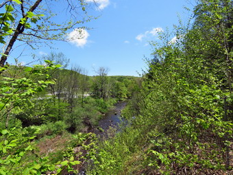
 At 1:30 PM I put my gear in the car and Sheila in the back seat and headed out Old Route 17 and drove across the Flats. I took Old Route 17 and Service Road to the point where they meet Fox Mountain Road. There was one car in the parking lot and I could see the owner returning on the trail with her dog. I set my GPS this time and we started out on the trail at 1:45 PM with the temperature at 71 degrees under skies with gathering dark clouds and a stiff breeze. The open trail just before the woods was dry. Usually as we enter the trees the temperature seems to drop but on this day there was not much change except some protection from the breeze. There had been some rain the previous day so I did not know what to expect on the trail. We immediately ran into some mud pits but they were almost completely dried up. One look down to the Little Beaverkill showed the stream volume was adequate but not much higher than our last visit. I wondered about the condition of the falls and whether they would be as interesting as my last trip. Sheila was taking her own route and following her nose and getting very close to the edge of the trail where a steep drop led down to the river! We were soon at the wooden walkways and I decided I would not take pictures down to the river because of the threat of thunderstorms. We continued over the wooden walkways and bridges which were almost dry. I thought about bringing a rake and a broom next time to clean off the bridges. There were also some small branches that needed lopping or cutting with a small saw. This time the water from the small stream was actually flowing through the culvert under the bridge.
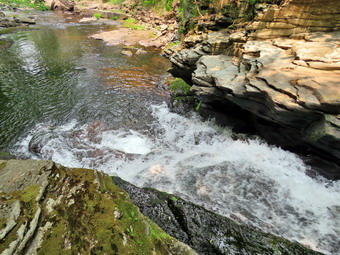
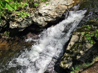
 After crossing the bridge, we ran into another large mud pit that had all but dried up. We continued at a fast pace as the breeze continued to keep us rather cool. As we approached the falls, we could hear the sound of the falls. We arrived at the falls and found that there was a nice flow of crystal-clear water although the volume was still low and seemed unaffected by the rain. I decided to skip taking pictures as the scene was much the same as during the last trip and the clouds were getting darker. I thought about turning around but we continued walking toward Parksville to get a little more distance. We found a few more damp areas on the trail but they were easy to walk around. We continued on to the end of the trail and turned around at the sign detailing the hotels in Parksville. We tunrned around at 2:10 PM and set a fast pace back toward the car passing the falls on the way. When I could get a look at the skies, I could see they were still dark but it did not seem that rain was imminent. We walked back to the car arriving at 2:35 PM after hiking about 2.6 miles in 55 minutes! There is virtually no elevation gain on the hike. I thought about extending the hike by walking rail trail from Fox Mountain Road toward Livingston Manor. This part of the trail is not officially open but is in good shape for hiking. In the end I decided to head home. I drove back home and parked in the driveway.
![]()
![]()
![]()
![]()
![]() On Tuesday, June 6th I wanted to get out for a hike but had to try to plan around the numerous ambulance calls we had been getting. At 7:00 AM, the temperature was 45 degrees and the skies were hazy and overcast from the forest fires burning in Canada. I had some work to do around the house and Cindy needed to do some shopping. When she returned. I asked if she would like to take a hike on the Parksville Rail Trail and she agreed. The hike is about 2.5 miles and the falls are beautiful. We started to get ready at 11:15 AM with Sheila showing her excitement. We had been hiking more regularly in May than in April but as I was getting dressed it looked as if she thought we might not hike again! I decided to wear my White Sierra long-sleeved crew shirt without a baselayer. I wore my Railriders hiking pants which are expensive but last along time and have features like deep pockets and a generous cut which I really like. The pants have Velcro closures at the ankles. I decided to put on my new Keen Durand hiking boots which I ordered a half size larger than the previous pair. These shoes fit well out of the box but get much tighter when I add a decent insole. Without the third party insole, by feet hurt from the lack of support. I added a new pair of Xstance insoles in an effort to find the best support and cushioning for my feet. These insoles have shock absorbing gel pads, TPU arch support, and memory foam cushioning all wrapped in a breathable fabric. The insoles have been hyped by their manufacturer and they really do seem to deliver. I decided to take my Leki poles with external locks as the internal twist locks sometimes fail. I did not see a reason to wear a jacket even though the tempertaure was still only in the high 50's. At 11:40 AM I put our gear in the car and Sheila in the back seat and headed out Old Route 17 and drove across the Flats. I took Old Route 17 and Service Road to the point where they meet Fox Mountain Road. There were no vehicles in the parking lot.
On Tuesday, June 6th I wanted to get out for a hike but had to try to plan around the numerous ambulance calls we had been getting. At 7:00 AM, the temperature was 45 degrees and the skies were hazy and overcast from the forest fires burning in Canada. I had some work to do around the house and Cindy needed to do some shopping. When she returned. I asked if she would like to take a hike on the Parksville Rail Trail and she agreed. The hike is about 2.5 miles and the falls are beautiful. We started to get ready at 11:15 AM with Sheila showing her excitement. We had been hiking more regularly in May than in April but as I was getting dressed it looked as if she thought we might not hike again! I decided to wear my White Sierra long-sleeved crew shirt without a baselayer. I wore my Railriders hiking pants which are expensive but last along time and have features like deep pockets and a generous cut which I really like. The pants have Velcro closures at the ankles. I decided to put on my new Keen Durand hiking boots which I ordered a half size larger than the previous pair. These shoes fit well out of the box but get much tighter when I add a decent insole. Without the third party insole, by feet hurt from the lack of support. I added a new pair of Xstance insoles in an effort to find the best support and cushioning for my feet. These insoles have shock absorbing gel pads, TPU arch support, and memory foam cushioning all wrapped in a breathable fabric. The insoles have been hyped by their manufacturer and they really do seem to deliver. I decided to take my Leki poles with external locks as the internal twist locks sometimes fail. I did not see a reason to wear a jacket even though the tempertaure was still only in the high 50's. At 11:40 AM I put our gear in the car and Sheila in the back seat and headed out Old Route 17 and drove across the Flats. I took Old Route 17 and Service Road to the point where they meet Fox Mountain Road. There were no vehicles in the parking lot.
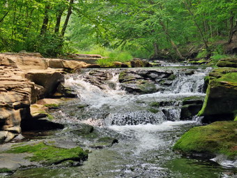
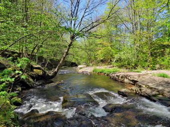
We started out on the trail at 11:55 AM with the temperature at 58 degrees under sunny skies with white clouds but there was also a stiff breeze. The open trail just before the woods was dry. Usually as we enter the trees the temperature seems to drop but on this day there was not much change except some protection from the breeze. We immediately ran into some mud pits but they were almost completely dried up. One look down to the Little Beaverkill showed the stream volume was adequate despite the dry weather we had been having. The water was also very clear. I wondered about the condition of the falls and whether they would be as interesting as my last trip. Sheila was taking her own route and following her nose and getting very close to the edge of the trail where a steep drop led down to the river! Its bothers me only a little but it drives Cindy crazy. We were soon at the wooden walkways and I decided I would not take pictures down to the river because of the haze created by the forest fires. We continued over the wooden walkways and bridges which were dry allowing us to move freely. I thought about bringing a rake and a broom next time to clean off the bridges. There were also some small branches that needed lopping or cutting with a small saw. This time the water from the small stream was actually flowing through the culvert under the bridge. After crossing the bridge, we ran into another large mud pit that had all but dried up. We continued at a fast pace as the breeze continued to keep us rather cool. As we approached the falls, we could hear the sound of the falls.
We arrived at the falls and found that there was a nice flow of crystal-clear water although the volume was the lowest we had seen since last fall. I decided to take some picture from above before descending the path to the streambed. I got out my camera and took some shots of the falls from above. I also took some pictures of the stream below the falls. I packed up and started walking down the path to the streambed. The path was dry and I was soon at the stream. I started to take pictures of the main falls and the rapids at its base. I also took some pictures downstream. Sheila walked upstream and took a swim in the water before posing on the rocks. I took some shots as she posed and then changed poses. The colors were vibrant and I made sure to take some pictures with longer exposures to get a "soft" effect. When I was done, Sheila and I walked back up the path to the picnic able. I grabbed my pack and we all walked on the trail to the next bench. I put down my pack and poles and started down the path that parallels the stream. The rocks on the path were mossy and wet but I did not have a problem walking to the brink of the falls. I stopped and took some pictures over the brink of the falls and then some upstream where there are more rapids. When I was done, Sheila and I walked back along the path to the bench. I stowed the camera and we started walking toward Parksville. We found a few more damp areas on the trail but they were easy to walk around. We continued on to the end of the trail and turned around at the sign detailing the hotels in Parksville. We tunrned around at 12:45 PM and set a fast pace back toward the car passing the falls on the way. A little farther along, we looked up to see a woman with a dog headed back toward the parking area. About half a mile from the parking area my phone sounded indicating an ambulance call. I responded and we all walked as fast as we could to the car. We were back at the car at 1:20 PM after hiking about 2.6 miles in 1 hour and 25 minutes! There is virtually no elevation gain on the hike. I drove directly to the ambulance building where the rig was waiting for me.
![]()
![]()
![]()
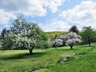
![]() On Tuesday, May 30th I had intended to get up early and do a longer hike before track practice. As often happens, my plans were changed by an early morning ambulance call. I had hoped to hike every day in May but a series of track meets, ambulance calls and church commitments interfered with that plan and continues to do so. I got a text from Lisa asking if I would like to hike on Round Top after she closed her store. I agreed that we would meet in the church parking lot at 5:30 PM. I got some work done around the house and at the ambulance building and was done by 5:00 PM so I could get ready to hike. The temperature was still 70 degrees with some sun, blue skies and white clouds even though the sun was beginning to sink in the sky. Sheila was quitely watching my every move but I knew she was excited as we had not been out for a week! I decided to put on my White Sierra long-sleeved crew top without a baselayer. I wore my Railriders hiking pants which are expensive but last along time and have features like deep pockets and a generous cut which I really like. The pants have Velcro closures at the ankles. I decided to put on a new apir of Keen Durand hiking boots in size 9.5W. The smaller pair that I had were beginning to wear out, a little prematurely I thought. In addition, the shoes were too small to use the better insoles that I like. I decided to wear this pair with the Keen insoles as I was just breaking them in. I have been wearing a new pair of Xstance insoles in an effort to find the best support and cushioning for my feet. These insoles have shock absorbing gel pads, TPU arch support, and memory foam cushioning all wrapped in a breathable fabric. The insoles have been hyped by their manufacturer and they really do seem to deliver. I decided to take my Leki poles with external locks as the internal twist locks sometimes fail. I chose not to wear any jacket as it was a little too warm outside. At 12:00 PM Sheila and I walked out the door to start the hike. I had grabbed Sheila's leash from my trunk and we walked up the driveway. We walked across the street and to the parking lot of the Presbyterian Church. Lisa was already parked and as soon as Sheila saw her she began to pull on her leash. When we finally got to Lisa's car Sheila was energetic but not too crazed. Lisa gave her a few pats and Sheila calmed down. When Lisa finished putting on her shoes, we walked behind the church to get to the road up the hill to the trailhead.
On Tuesday, May 30th I had intended to get up early and do a longer hike before track practice. As often happens, my plans were changed by an early morning ambulance call. I had hoped to hike every day in May but a series of track meets, ambulance calls and church commitments interfered with that plan and continues to do so. I got a text from Lisa asking if I would like to hike on Round Top after she closed her store. I agreed that we would meet in the church parking lot at 5:30 PM. I got some work done around the house and at the ambulance building and was done by 5:00 PM so I could get ready to hike. The temperature was still 70 degrees with some sun, blue skies and white clouds even though the sun was beginning to sink in the sky. Sheila was quitely watching my every move but I knew she was excited as we had not been out for a week! I decided to put on my White Sierra long-sleeved crew top without a baselayer. I wore my Railriders hiking pants which are expensive but last along time and have features like deep pockets and a generous cut which I really like. The pants have Velcro closures at the ankles. I decided to put on a new apir of Keen Durand hiking boots in size 9.5W. The smaller pair that I had were beginning to wear out, a little prematurely I thought. In addition, the shoes were too small to use the better insoles that I like. I decided to wear this pair with the Keen insoles as I was just breaking them in. I have been wearing a new pair of Xstance insoles in an effort to find the best support and cushioning for my feet. These insoles have shock absorbing gel pads, TPU arch support, and memory foam cushioning all wrapped in a breathable fabric. The insoles have been hyped by their manufacturer and they really do seem to deliver. I decided to take my Leki poles with external locks as the internal twist locks sometimes fail. I chose not to wear any jacket as it was a little too warm outside. At 12:00 PM Sheila and I walked out the door to start the hike. I had grabbed Sheila's leash from my trunk and we walked up the driveway. We walked across the street and to the parking lot of the Presbyterian Church. Lisa was already parked and as soon as Sheila saw her she began to pull on her leash. When we finally got to Lisa's car Sheila was energetic but not too crazed. Lisa gave her a few pats and Sheila calmed down. When Lisa finished putting on her shoes, we walked behind the church to get to the road up the hill to the trailhead.
We began the ascent of the steepest hill behind the church. The hill is short but gets the circulation pumping and is the steepest and longest climb on the "trail." My goal is always to make it all the way up the hill without stopping which I was able to do by picking the right pace. At the top of the hill we turned left and entered the woods to begin our hike. The trail was dry and there were no wet spots or muddy places to make it slippery. At the first trail junction, we followed Sheila as she continued straight ahead up the hill toward the lookout. When we reached the top of the trail, we walked off the trail to the left to the upper viewpoint. The views down into town and across the valley to the hills was beautiful and I was a little sorry I had not brought the camera. After taking in the view, we followed the yellow trail as it headed uphill toward the next trail junction. As we walked, we talked. Lisa and I had mot hiked in some time and we had a lot to discuss. We passed the "sitting rock" and continued on the yellow trail to the first junction with the blue trail. At the junction we turned right and walked on the yellow trail along the base of Round Top. At the next junction with the blue trail, we turned left and started up toward the summit. Everything was very green and there were a few branches encroaching on the trail. We bypassed the white crossover trail and walked over the summit to start down the other side. We again bypassed the white crossover trail but turned left on the switchback in the blue trail. The switchback took us out into the woods before turning almost 180 degrees to take us back to the main blue trail. We turned left and walked downhill to the yellow trail where we turned left. We again walked along the base of Round Top on the yellow trail. This time when we reached the trail junction we turned right to head down the trail to the woods road. We continued to follow the yellow blazes back to the first trail junction. I asked Lisa if she would like to do another figure 8. She declined but agreed to do a small loop. We turned around and walked back up the woods road to begin another figure 8. At the junction with the blue trail we turned left and walked along the base of Round Top on the yellow trail. At the trail junction with the blue trail we turned left to do a small loop on the lower yellow trail. We again assed the "Sitting Rock" and headed toward the lookout. At the lookout we turned left and walked down the steep hill to the first trail junction. This time we continued straight ahead and walked out to the trailhead where we turned right. We walked down the hill to the church parking lot. We both said our goodbyes to Lisa. I put Sheila on her leash and we walk out to the street. We crossed the street to the driveway and walked back home. We were back at 6:45 PM after walking not quite two miles in 1 hour and 15 minutes.
![]()
![]()
![]()
![]()
![]() On Tuesday, May 23rd I had planned to get out and hike a longer hike in the Neversink Unique Area but two overnight ambulance calls had me sleeping in until 10:00 AM. The day looked beautiful and I asked Cindy if she wanted to go for a walk. She turned me down immediately so I began to think of places to go that were closer to home. I decided to head for Huggins Lake. This hike is about 4 miles but has some good uphills and is always deserted. I began to get ready at 12:15 PM when the temperature was 77 degrees. As soon as I started to get ready, Sheila began to run around and bark anticipating getting out of the house. I got dressed in my Mammut crew top but decided against a baselayer. I put on a pair of RailRiders hiking pants which are expensive but last along time and have features like deep pockets and a generous cut which I really like. The pants have Velcro closures at the ankles. I decided not to add gaiters. I have not seen as many ticks as in the past but I know they are out there. I decided to put on my Keen Durand hiking boots which fit well and are newer than what I have been wearing. I added a new pair of Xstance insoles in an effort to find the best support and cushioning for my feet. These insoles have shock absorbing gel pads, TPU arch support, and memory foam cushioning all wrapped in a breathable fabric. The insoles have been hyped by their manufacturer and they really do seem to deliver. I grabbed a pair of Leki external lock poles I have been using lately. I got my gear in the car and Sheila in the backseat. We left Livingston Manor at 12:45 PM and drove north on Old Route 17. I turned right on the Beaverkill Road and left on Campsite Road. At the bottom of the hill I turned right and drove down to the campgrounds parking area and across the Beaverkill Covered Bridge. At the end of the road I turned right and followed Berry Brook Road to the trailhead for Huggins Lake. We arrived at the road to the parking area to find it very rough with a lot erosion. I decided to give it a try and was able to get to the parking lot. I got my equipment ready and we started off at 1:05 PM. The sun had been out all day and the sky was a beautiful blue with white clouds. The temperature was 74 degrees as we headed out on the wide woods road to the lake but a slight breeze made it feel cooler. The hike isn't long, less than 4 miles, and the trail is maintained by the DEC and we saw a few blowdowns along the way that had been cleared.
On Tuesday, May 23rd I had planned to get out and hike a longer hike in the Neversink Unique Area but two overnight ambulance calls had me sleeping in until 10:00 AM. The day looked beautiful and I asked Cindy if she wanted to go for a walk. She turned me down immediately so I began to think of places to go that were closer to home. I decided to head for Huggins Lake. This hike is about 4 miles but has some good uphills and is always deserted. I began to get ready at 12:15 PM when the temperature was 77 degrees. As soon as I started to get ready, Sheila began to run around and bark anticipating getting out of the house. I got dressed in my Mammut crew top but decided against a baselayer. I put on a pair of RailRiders hiking pants which are expensive but last along time and have features like deep pockets and a generous cut which I really like. The pants have Velcro closures at the ankles. I decided not to add gaiters. I have not seen as many ticks as in the past but I know they are out there. I decided to put on my Keen Durand hiking boots which fit well and are newer than what I have been wearing. I added a new pair of Xstance insoles in an effort to find the best support and cushioning for my feet. These insoles have shock absorbing gel pads, TPU arch support, and memory foam cushioning all wrapped in a breathable fabric. The insoles have been hyped by their manufacturer and they really do seem to deliver. I grabbed a pair of Leki external lock poles I have been using lately. I got my gear in the car and Sheila in the backseat. We left Livingston Manor at 12:45 PM and drove north on Old Route 17. I turned right on the Beaverkill Road and left on Campsite Road. At the bottom of the hill I turned right and drove down to the campgrounds parking area and across the Beaverkill Covered Bridge. At the end of the road I turned right and followed Berry Brook Road to the trailhead for Huggins Lake. We arrived at the road to the parking area to find it very rough with a lot erosion. I decided to give it a try and was able to get to the parking lot. I got my equipment ready and we started off at 1:05 PM. The sun had been out all day and the sky was a beautiful blue with white clouds. The temperature was 74 degrees as we headed out on the wide woods road to the lake but a slight breeze made it feel cooler. The hike isn't long, less than 4 miles, and the trail is maintained by the DEC and we saw a few blowdowns along the way that had been cleared.
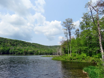
 The first 1.2 miles is all uphill and gains almost 700 feet. Sheila was running up and down the trail following game paths into the woods. I often wonder how many miles she puts on as I plod along the trails. I was deep in thought about pastoring my new church and it seemed that we were setting a fast pace. The ascent has several spots which appear to be the top of the climb but are not. After the initial climb, the trail descends, levels some and then climbs again until the final descent to Huggins Lake. As we continued, the trail made a sharp turn from southeast to north at about 1.6 miles. We enjoyed the downhill trek to the shores of the pond even though we had to walk around some small blowdowns on the trail. I have found the maintenance on the woods road to be spotty at best. I knew we would soon have to turn around and climb back up the hill. When we arrived at the lake, I noticed that the water level was high. I dropped my pack and got out my camera to take pictures of the lake. The sky was almost perfect and the lighting very good. I took some pictures of the lake and the hills that surround it. At the outlet I could immediately see that the beavers had dammed the water flow and that reeds had grown to all but block the outlet flow. Sheila took a dip in the water which was her first of the season. I took some pictures of her as she posed for these shots. I took a few more pictures of the lake before returning to my pack and stowing the camera. Sheila had already taken a dip in the water and had also taken a drink! We spent about 10 minutes at the lake and then packed up at 2:15 PM and started up the hill and back to the car. The only negative point about Huggins Lake is that there is only one trail and so there are no variations available. I had thought about bushwhacking around the lake but the ascent on the other side is very steep. The ascent on the woods road went smoothly for the most part as we climbed the hill back to the highest point on the trail. I was surprised that there were very few muddy spots on the trail. From there we started down the other side of the hill on the trail. Downhill was definitely easier than uphill! Sheila seemed very interested in following game trails off the main trail and I had to keep calling her back. From the highest point it was all downhill to the car. We arrived back at the car at 3:05 PM after hiking 3.9 miles in 2 hours with a total elevation gain of 920 feet.
![]()
![]()
![]()
![]() On Friday, May 19th I decided to get out for a little longer hike as I did not have track practice in the afternoon. My plans were altered by several ambulance calls so I was not back to the house until 1:30 PM. I decided to go to Frick Pond. My first thought was to hike the big loop around Frick and Hodge Ponds but I knew there were many options I could use. As I got my gear together at 1:45 PM the temperature was 65 degrees. Sheila seemed to be in complete agreement with my decision as she followed me around as I was dressing. I got dressed in my Mammut crew top but decided against a baselayer. I put on a pair of RailRiders hiking pants which are expensive but last along time and have features like deep pockets and a generous cut which I really like. The pants have Velcro closures at the ankles. I decided not to add gaiters. I have not seen as many ticks as in the past but I know they are out there. I decided to put on my Keen Durand hiking boots which fit well and are newer than what I have been wearing. I added a new pair of Xstance insoles in an effort to find the best support and cushioning for my feet. These insoles have shock absorbing gel pads, TPU arch support, and memory foam cushioning all wrapped in a breathable fabric. The insoles have been hyped by their manufacturer and they really do seem to deliver. I grabbed a pair of Leki external lock poles I have been using lately. I decided not to put on any kind of jacket but added a pair of OR Bugout gaiters to combat the mud I thought I might find. I had not completely planned a route but thought we would hike out the Quick Lake Trail to Iron Wheel Junction and then make a decision which direction we would go. Sheila was happy to be going anywhere and crouched in the back seat with her head on the console. I drove out DeBruce Road just before 2:00 PM. After 6 miles I turned left on Mongaup Road. Where the road splits, I stayed left on Beech Mountain Road and parked in the smaller lot at 2:10 PM. There were no other cars in the lots which did not surprise me. I set my GPS unit to get ready for the hike. We started out the woods road that becomes the Quick Lake Trail at the register box. Starting at the register the trail was damp but not wet and there was only a little mud but it was clear that the drainage work we had done was helping to direct some of the water off the trail. The woods road out to Frick Pond continued to be samp but we were able to avoid the worst spots. We stayed left at Gravestone Junction to stay on the Quick Lake Trail. When we arrived at the bridge across the outlet, I decided to not to stop and take pictures. I thought I might not take any pictures on the trip as I just wanted to hike! The water level in the pond was moderately high and the outlet stream was flowing freely.Point.
On Friday, May 19th I decided to get out for a little longer hike as I did not have track practice in the afternoon. My plans were altered by several ambulance calls so I was not back to the house until 1:30 PM. I decided to go to Frick Pond. My first thought was to hike the big loop around Frick and Hodge Ponds but I knew there were many options I could use. As I got my gear together at 1:45 PM the temperature was 65 degrees. Sheila seemed to be in complete agreement with my decision as she followed me around as I was dressing. I got dressed in my Mammut crew top but decided against a baselayer. I put on a pair of RailRiders hiking pants which are expensive but last along time and have features like deep pockets and a generous cut which I really like. The pants have Velcro closures at the ankles. I decided not to add gaiters. I have not seen as many ticks as in the past but I know they are out there. I decided to put on my Keen Durand hiking boots which fit well and are newer than what I have been wearing. I added a new pair of Xstance insoles in an effort to find the best support and cushioning for my feet. These insoles have shock absorbing gel pads, TPU arch support, and memory foam cushioning all wrapped in a breathable fabric. The insoles have been hyped by their manufacturer and they really do seem to deliver. I grabbed a pair of Leki external lock poles I have been using lately. I decided not to put on any kind of jacket but added a pair of OR Bugout gaiters to combat the mud I thought I might find. I had not completely planned a route but thought we would hike out the Quick Lake Trail to Iron Wheel Junction and then make a decision which direction we would go. Sheila was happy to be going anywhere and crouched in the back seat with her head on the console. I drove out DeBruce Road just before 2:00 PM. After 6 miles I turned left on Mongaup Road. Where the road splits, I stayed left on Beech Mountain Road and parked in the smaller lot at 2:10 PM. There were no other cars in the lots which did not surprise me. I set my GPS unit to get ready for the hike. We started out the woods road that becomes the Quick Lake Trail at the register box. Starting at the register the trail was damp but not wet and there was only a little mud but it was clear that the drainage work we had done was helping to direct some of the water off the trail. The woods road out to Frick Pond continued to be samp but we were able to avoid the worst spots. We stayed left at Gravestone Junction to stay on the Quick Lake Trail. When we arrived at the bridge across the outlet, I decided to not to stop and take pictures. I thought I might not take any pictures on the trip as I just wanted to hike! The water level in the pond was moderately high and the outlet stream was flowing freely.Point.
We continued on around the pond staying left at the trail junction to stay on the Quick Lake Trail. Surprisingly, the trail was much drier than I expected with only a few damp spots and one wet spot which was easily crossed. We continued on our hike passing through the "Spruce Tunnel." There were several large blowdowns which would be difficult to cut with hand tools. I made a not to call the local ranger who likes to use a chainsaw. The small stream through the woods was running freely but was nit very high. I easily stepped across using some stones while Sheila waded through the water. There were several places on the trail where it was obvious that there had been a large flow of water. A few spots were muddy and there was another large blowdown that should be removed. By 2:50 PM we had walked the 1.5 miles to Iron Wheel Junction. At the trail junction, we turned right of the Loggers' Loop as I wanted to get back before 5:00 PM. The Logger's Loop is mostly downhill in this direction, and we made good time. This trail was also relatively dry and any wet spots were easily bypassed. Just before starting the descent to Times Square, we passed the small pond on the left side of the trail. This pond is seasonal but has been growing in size for several years. On this day it was almost dry with just a small amount of water. We continued down the hill to Times Square. The final descent to the trail junction was wet. At Times Square we had hiked about 2.7 miles and I had to make a choice about what route we would take. The area was damp and will require some major work to fix the situation. I decided I wanted a little more distance and some hill climbing so we made the left turn up the Big Rock Trail. I had really considered simply walking the Logger's Loop back to Gravestone Junction as we were both tired but decided the challenge would be good. The Big Rock Trail gains 600 feet to the Flynn Trail over 1.1 miles. The average grade is only 10%, but the route has three different climbs and can seem long. We set a pretty fast pace on the climb, and I found that although my heart rate was elevated, I felt good. As we ascended the trail I began to tire but Sheila showed no signs of slowing down. We reached the Flynn Trail at 3:55 PM after hiking 3.75 miles, and immediately turned right and began the descent back to the car. Sheila was still excited at this point and was running up the trail and back to me. She was taking a few excursions off the trail to follow animal tracks but was pretty close, so I let her explore. The trip down the Flynn Trail was very dry and the trip, which can seem long, went quickly. I was glad we were going down! We arrived at the gate that blocks Beech Mountain Road and turned left to stay on the Flynn Trail as it continues through the woods. This avoids the private property around the cabin. Some hikers cannot read the signs and have annoyed the property owner by trespassing! There were several large blowdowns on the trail which would require a chainsaw. We continued down to the parking area on the trail. We were back at 4:40 PM having covered 5.4 miles in 2 hours and 25 minutes with a vertical gain of 885 feet.
![]()
![]()
![]()
![]()
![]() On Wednesday 17th I wanted to get out for a hike before track practice. When I got up at 7:00 AM, the temperature was 45 degrees but the skies were clear and the sun was shining. I had some work to do around the house and Cindy needed to do some shopping. When she returned. I asked if she would like to take a hike on the Parksville Rail Trail. I asked Cindy if she would like to hike the Parksville Rail Trail and she agreed. The hike is about 2.5 miles and the falls are beautiful. We started to get ready at 11:30 AM with Sheila showing her excitement. We had been hiking more regularly in May than in April but as I was getting dressed it looked as if she thought we might not hike again! I decided to wear my White Sierra long-sleeved crew shirt without a baselayer. I wore my Railriders hiking pants which are expensive but last along time and have features like deep pockets and a generous cut which I really like. The pants have Velcro closures at the ankles. I decided to put on my Keen Durand hiking boots which fit well and are newer than what I have been wearing. I added a new pair of Xstance insoles in an effort to find the best support and cushioning for my feet. These insoles have shock absorbing gel pads, TPU arch support, and memory foam cushioning all wrapped in a breathable fabric. The insoles have been hyped by their manufacturer and they really do seem to deliver. I decided to take my Leki poles with external locks as the internal twist locks sometimes fail. I did don my Mammut hoody as it has enough zippers to dump heat if needed. At 12:00 PM I put our gear in the car and Sheila in the back seat and headed out Old Route 17 and drove across the Flats. I took Old Route 17 and Service Road to the point where they meet Fox Mountain Road. There were no vehicles in the parking lot.
On Wednesday 17th I wanted to get out for a hike before track practice. When I got up at 7:00 AM, the temperature was 45 degrees but the skies were clear and the sun was shining. I had some work to do around the house and Cindy needed to do some shopping. When she returned. I asked if she would like to take a hike on the Parksville Rail Trail. I asked Cindy if she would like to hike the Parksville Rail Trail and she agreed. The hike is about 2.5 miles and the falls are beautiful. We started to get ready at 11:30 AM with Sheila showing her excitement. We had been hiking more regularly in May than in April but as I was getting dressed it looked as if she thought we might not hike again! I decided to wear my White Sierra long-sleeved crew shirt without a baselayer. I wore my Railriders hiking pants which are expensive but last along time and have features like deep pockets and a generous cut which I really like. The pants have Velcro closures at the ankles. I decided to put on my Keen Durand hiking boots which fit well and are newer than what I have been wearing. I added a new pair of Xstance insoles in an effort to find the best support and cushioning for my feet. These insoles have shock absorbing gel pads, TPU arch support, and memory foam cushioning all wrapped in a breathable fabric. The insoles have been hyped by their manufacturer and they really do seem to deliver. I decided to take my Leki poles with external locks as the internal twist locks sometimes fail. I did don my Mammut hoody as it has enough zippers to dump heat if needed. At 12:00 PM I put our gear in the car and Sheila in the back seat and headed out Old Route 17 and drove across the Flats. I took Old Route 17 and Service Road to the point where they meet Fox Mountain Road. There were no vehicles in the parking lot.
 We started out on the trail at 12:15 PM with the temperature at 58 degrees under sunny skies with white clouds but there was also a stiff breeze. The open trail just before the woods was dry. Usually as we enter the trees the temperature seems to drop but on this day there was not much change except some protection from the wind. We immediately ran into some mud pits but we were able to walk along the side of the trail without any problems. One look down to the Little Beaverkill showed the stream volume was adequate and the water was very clear. I wondered about the condition of the falls and whether they would be as interesting as my last trip. Sheila was taking her own route and following her nose and getting very close to the edge of the trail where a steep drop led down to the river! We were soon at the wooden walkways and I decided I would take some pictures down to the river. I was disappointed there were only a few clouds in the sky. We continued over the wooden walkways and bridges which were dry allowing us to move freely. This time the water from the small stream was actually flowing through the culvert under the bridge. After crossing the bridge, we ran into another large mud pit and I began to form a plan to remediate the mud problem. It seems that most of the mud forms when water drains off the Quickway into small streams that run across the rail trail. One solution would be to dig some trenches across the trail to allow the water to drain rather than to pool to form mud pits. As we walked, we saw a couple coming toward us and I put Sheila on her leash. As the couple approached, we could see they also had a dog but they were carrying it! We passed by each other with a "Hello". Shortly after this we met a young man walking with his earbuds in place. I said "Hello" but he passed by as if we were not there. We continued at a fast pace as the breeze continued to keep us rather cool. As we approached the falls, we could hear the sound of the falls.
 We arrived at the falls and found that there was a nice flow of crystal-clear water. I decided to take some picture from above without following the path down to the stream. I got out my camera and took some shots of the falls from above. I also took some pictures of the stream above Stewart State Forest Swamp 8 below the falls. I packed up and we started walking toward Parksville but I decided to stop at the next bench where a path goes down to the stream above the falls. I took out my camera and snapped some shots of the water from different angles. I put my camera away and decided we had enough time to continue to Parksville. We found a few more wet areas on the trail but they were easy to walk around. We continued on to the end of the trail and turned around at the sign detailing the hotels in Parksville. As we started back toward the car, we met the couple with the dog. They let the dog walk for a hundred feet and then picked him up to carry him. We also met the other young man who passed right by us again. We made quick work of the rest of the trail. We were back at the car at 1:25 PM after hiking about 2.6 miles in 1 hour and 10 minutes! This time was much quicker than I expected and even included the time to take pictures. There is virtually no elevation gain on the hike.
![]()
![]()
![]()
![]() On Monday, May 15th I had intended to get up early and do a longer hike before track practice. As often happens, my plans were changed by an early morning ambulance call. I had hoped to hike every day in May but a series of track meets, ambulance calls and church commitments interfered with that plan and continues to do so. By the time I got home it was 11:30 AM and I decided to once again head across the street to Round Top to get some exercise with Sheila. The temperature was up to 60 degrees with bright sun, blue skies and white clouds. Sheila was quitely watching my every move but I knew she was excited as we had not been out for a couple of days. I decided to put on my Mammut long-sleeved crew top without a baselayer. I wore my Railriders hiking pants which are expensive but last along time and have features like deep pockets and a generous cut which I really like. The pants have Velcro closures at the ankles. I decided to put on my Keen Durand hiking boots which fit well and are newer than what I have been wearing. I added a new pair of Xstance insoles in an effort to find the best support and cushioning for my feet. These insoles have shock absorbing gel pads, TPU arch support, and memory foam cushioning all wrapped in a breathable fabric. The insoles have been hyped by their manufacturer and they really do seem to deliver. I decided to take my Leki poles with external locks as the internal twist locks sometimes fail. I chose not to don my Mammut hoody as it was a little too warm outside. At 12:00 PM we walked out the door to start the hike. I had grabbed Sheila's leash from my trunk and we walked up the driveway. We walked across the street and to the parking lot of the Presbyterian Church. We walked behind the church to get to the road up the hill to the trailhead.
On Monday, May 15th I had intended to get up early and do a longer hike before track practice. As often happens, my plans were changed by an early morning ambulance call. I had hoped to hike every day in May but a series of track meets, ambulance calls and church commitments interfered with that plan and continues to do so. By the time I got home it was 11:30 AM and I decided to once again head across the street to Round Top to get some exercise with Sheila. The temperature was up to 60 degrees with bright sun, blue skies and white clouds. Sheila was quitely watching my every move but I knew she was excited as we had not been out for a couple of days. I decided to put on my Mammut long-sleeved crew top without a baselayer. I wore my Railriders hiking pants which are expensive but last along time and have features like deep pockets and a generous cut which I really like. The pants have Velcro closures at the ankles. I decided to put on my Keen Durand hiking boots which fit well and are newer than what I have been wearing. I added a new pair of Xstance insoles in an effort to find the best support and cushioning for my feet. These insoles have shock absorbing gel pads, TPU arch support, and memory foam cushioning all wrapped in a breathable fabric. The insoles have been hyped by their manufacturer and they really do seem to deliver. I decided to take my Leki poles with external locks as the internal twist locks sometimes fail. I chose not to don my Mammut hoody as it was a little too warm outside. At 12:00 PM we walked out the door to start the hike. I had grabbed Sheila's leash from my trunk and we walked up the driveway. We walked across the street and to the parking lot of the Presbyterian Church. We walked behind the church to get to the road up the hill to the trailhead.
We began the ascent of the steepest hill behind the church. The hill is short but gets the circulation pumping and is the steepest and longest climb on the "trail." My goal is always to make it all the way up the hill without stopping which I was able to do by picking the right pace. At the top of the hill we turned left and entered the woods to begin our hike. The trail was dry and there were no wet spots or muddy places to make it slippery. At the first trail junction, I followed Sheila as she continued straight ahead up the hill toward the lookout. When we reached the top of the trail, we walked off the trail to the left to the upper viewpoint. The views down into town and across the valley to the hills was beautiful and I was a little sorry I had not brought the camera. After taking in the view, we followed the yellow trail as it headed uphill toward the next trail junction. We passed the "sitting rock" and continued on the yellow trail to the first junction with the blue trail. At the junction we turned right and walked on the yellow trail along the base of Round Top. At the next junction with the blue trail, we turned left and started up toward the summit. We bypassed the white crossover trail and walked over the summit to start down the other side. We again bypassed the white crossover trail but turned left on the switchback in the blue trail. The switchback took us out into the woods before turning almost 180 degrees to take us back to the main blue trail. We turned left and walked downhill to the yellow trail where we turned left. We again walked along the base of Round Top on the yellow trail. This time when we reached the trail junction we turned right to head down the trail to the woods road. We continued to follow the yellow blazes back to the first trail junction.
We turned around and walked back up the woods road to begin another figure 8. At the junction with the blue trail we turned left and walked along the base of Round Top on the yellow trail. At the trail junction with the blue trail we turned right and started up toward the summit. I had several options but decided just to do another figure 8. We turned right on the switchback and followed it out and back to the main trail. We bypassed the white crossover trail and continued on the blue trail over the summit of Round Top. On the way back down the blue trail we passed by the white crossover trail and came to the junction with the Yellow trail. We turned right and followed the yellow trail along the base of Round Top. At the next junction, we turned left and walked downhill along the yellow trail toward the viewpoint. We passed the "Sitting Rock" and continued to the lookout. We followed the yellow trail as it turned left and headed down to the first trail junction. We continued straight ahead and walked out to the trailhead where we turned right. We walked down the hill to the church parking lot. I put Sheila on her leash and we walk out to the street. We crossed the street to the driveway and walked back home. We were back at 1:15 PM after walking over two miles in 1 hour and 15 minutes.
![]()
![]()
![]()
![]() On Saturday, May 13th, I wanted to get out for a longer hike after sticking to Round Top and trail near home for several walks. I had an overnight ambulance call and slept in unit 8:30 AM. I knew that we only had an EMT available until 11:00 AM so I ate a quick breakfast and started to get ready to hike. Rather than travel too far I decided to go to Frick Pond and hike the Flynn Trail where I could hike some uphill miles. This would give me some choices of how far I wanted to hike and the route I would take. I also wanted to see if there were any trees that needed trimming to make hiking easier. As I started to get ready at 9:15 AM, the temperature on the back porch was 75 degrees with a slight breeze! I put on my Mammut long-sleeved crew top without a baselayer as it was fairly warm. I put on a pair of RailRiders hiking pants which are expensive but last along time and have features like deep pockets and a generous cut which I really like. I decided to put on my Keen Durand hiking boots which fit well and are newer than what I have been wearing. I added a new pair of Xstance insoles in an effort to find the best support and cushioning for my feet. These insoles have shock absorbing gel pads, TPU arch support, and memory foam cushioning all wrapped in a breathable fabric. The insoles have been hyped by their manufacturer and they really do seem to deliver. I decided to take my Leki poles with external locks as the internal twist locks sometimes fail. I did not think I would need my Mammut hoody as the temperature at the trailhead would be warm. I did where my OR brimmed hat as it acts as a base for insect repellant. I thought about putting my Silky Sugowaza saw in my pack but decided against it as I did not think I would have enough time. I put my gear in the back and Sheila in the backseat and headed out the DeBruce Road at 9:30 AM. After 6 miles, at Mongaup Pond Road, I turned left and continued to follow the road bearing left onto Beech Mountain Road at the fork. When we arrived in the parking area there was one car parked in the larger lot but the small lot was empty. I pulled into the smaller lot with Sheila acting as if she hadn't hiked in a month as she ran around and headed for the trail. The temperature was 72 degrees and the skies were blue with white clouds with a slight breeze blowing. I could see the gnats swarming so I sprayed some insect repellant on my hat and exposed skin. I set my GPS as we got ready to head out on the Flynn Trail. We crossed the road and began our hike at 9:50 AM.
On Saturday, May 13th, I wanted to get out for a longer hike after sticking to Round Top and trail near home for several walks. I had an overnight ambulance call and slept in unit 8:30 AM. I knew that we only had an EMT available until 11:00 AM so I ate a quick breakfast and started to get ready to hike. Rather than travel too far I decided to go to Frick Pond and hike the Flynn Trail where I could hike some uphill miles. This would give me some choices of how far I wanted to hike and the route I would take. I also wanted to see if there were any trees that needed trimming to make hiking easier. As I started to get ready at 9:15 AM, the temperature on the back porch was 75 degrees with a slight breeze! I put on my Mammut long-sleeved crew top without a baselayer as it was fairly warm. I put on a pair of RailRiders hiking pants which are expensive but last along time and have features like deep pockets and a generous cut which I really like. I decided to put on my Keen Durand hiking boots which fit well and are newer than what I have been wearing. I added a new pair of Xstance insoles in an effort to find the best support and cushioning for my feet. These insoles have shock absorbing gel pads, TPU arch support, and memory foam cushioning all wrapped in a breathable fabric. The insoles have been hyped by their manufacturer and they really do seem to deliver. I decided to take my Leki poles with external locks as the internal twist locks sometimes fail. I did not think I would need my Mammut hoody as the temperature at the trailhead would be warm. I did where my OR brimmed hat as it acts as a base for insect repellant. I thought about putting my Silky Sugowaza saw in my pack but decided against it as I did not think I would have enough time. I put my gear in the back and Sheila in the backseat and headed out the DeBruce Road at 9:30 AM. After 6 miles, at Mongaup Pond Road, I turned left and continued to follow the road bearing left onto Beech Mountain Road at the fork. When we arrived in the parking area there was one car parked in the larger lot but the small lot was empty. I pulled into the smaller lot with Sheila acting as if she hadn't hiked in a month as she ran around and headed for the trail. The temperature was 72 degrees and the skies were blue with white clouds with a slight breeze blowing. I could see the gnats swarming so I sprayed some insect repellant on my hat and exposed skin. I set my GPS as we got ready to head out on the Flynn Trail. We crossed the road and began our hike at 9:50 AM.
The Flynn Trail is sited along what used to be Beech Mountain Road which was the access for the Beech Mountain Boy Scout Camp. We walked the trail through the woods which was mostly dry. I immediately noticed that although my Achilles tendons were still aching with every step I was keeping up a good pace. After a short walk we came to the first blowdown that I knew was present. The problem was that a large tree had fallen across the trail and its 2 foot diameter was more than I could handle, at least on this day. I had cut and removed the other trees that had been brought down and were encroaching on the trail or hanging over it. We continued on the Flynn Trail and turned right on the woods road and continued to set a good pace up the hill. The trail gains a little over 600 feet in 1.7 miles to the highest point at the junction with the Big Rock Trail. We passed the hemlock that used to form a tunnel but was cleared by the DEC. Just after this there were several medium sized trees down across the trail. These would require hand tools to cut and remove but I knew I would get to them as they were so close to the trailhead. I began to find some small branches on the trail which I removed. I was surprised that there weren't more large branches or trees across the trail as we have had several storms with high winds. As we approached and the clearing to the right of the trail, we passed by some rock ledges on the right side of the trail. It was a beautiful day and the sun was shining in the rocks and the trail. I decided I was not going to stop to take pictures at all unless there was something remarkable. Most of the trees were sporting leaf buds or full-fledged leaves which made the forest very green. I noticed that I was very relaxed and decided I needed to get out more as the other things that I do can be stressful. I thought about visiting the clearing but decided I wanted to stay on the main trail. We kept walking uphill and we were soon at the junction with the Big Rock Trail. We turned left to walk down the Big Rock Trail. The trail continued to be dry. The hike down the trail went well and more quickly than I expected. It was definitely easier than the uphill hike. This trail can be tricky as there are several levels that make it seem like the bottom of the hill.
We were soon at Times Square and I thought about turning right to hike up and around the Logger's Loop to add some distance to our hike. I decided against this as it was getting late and we continued our hike by walking straight across Times Square to stay on the Big Rock Trail. This trail can be very wet and on this day it was damp with a few very muddy spots. There was a very large blowdown across the trail which I had trimmed but will require a chainsaw to eliminate. I was able to step across or skirt the mud but Sheila was just walking through these spots! We crossed the two small bridges over the inlets to the pond and this time I decided not to stop to take pictures. The water under the first bridge was backed up from the wetlands perhaps due to a beaver dam. The area under the second bridge had a stream fowling but the volume was low. The sun was working its way up in the sky giving a warm feeling to the setting. When we got to the area that was covered by tall evergreens, I pushed on through as I had taken pictures here many times before. The wooden boardwalks continue to show wear with many boards loose and other beginning to rot. Much of the boardwalk now "floats" in midair as the supports are rotting. The rest of the trail was damp with several wet and muddy spots. At the next trail junction we turned left on the Quick Lake Trail to head for the bridge across the outlet of Frick Pond. We walked along the west side of Frick Pond to the bridge across the outlet of the pond. The mudhole was wet and muddy but the drainage work and the stepping stones did their job. I heard voices near the bridge at the outlet of Frick Pond so I made sure Sheila was near me. As we crossed the bridge, we met a family of three headed toward us. They mentioned the metal bunk beds along the trail and I told them the story of the Lobdells. The father of this family was the caretaker for the Frick popery and the family lived in a cabin along what is now the Quick Lake Trail, One night the cabin caught fire. The parents were able to get out but their two children were trapped inside and died in the flames. Gravestone Junction is named for their memorial marker. I also gave the hiking family some tips on the trail system before we headed in opposite directions. I did not stop at the bridge to take photographs as I just wanted to hike. before we walked up the hill toward Gravestone Junction. We continued to Gravestone Junction and passed the Lobdell memorial marker. The trail back to the register was wet and muddy in spots. Most of the water was ground water seeping up from below. We passed the trail register heading toward the parking area. We continued straight ahead to follow the woods road out to the car in the small lot. We arrived at the car at 11:35 AM having hiked 4.1 miles in 1 hour and 45 minutes with an elevation gain of 690 feet. The temperature was 74 degrees. We had encountered relatively few insects and I suspected the breeze helped. As we passed Mongaup Pond Road, I thought about stopping to go to Mongaup Falls but kept driving instead!
![]()
![]()
![]()
![]()
![]() On Friday, May 12th I wanted to get out for a longer hike than the one on Round Top. As often happens I had to do some work at church but that was interrupted by an ambulance call. I finished everything I had to do and was ready to hike at 2:30 PM with the temperature at 83 degrees. I balked a little as it was late and hot but decided I would go anyway. I took a chance and asked Cindy if she would like to hike and she declined. I decided to hike the Parksville Rail Trail from Parksville toward Livingston Manor. I started to get ready at 2:30 PM. I got dressed in my White Sierra light crew top with a short-sleeved baselayer. I wore my Railriders hiking pants which are expensive but last along time and have features like deep pockets and a generous cut which I really like. The pants have Velcro closures at the ankles. I decided to put on my Keen Durand hiking boots which fit well and are newer than what I have been wearing. I added a new pair of Xstance insoles in an effort to find the best support and cushioning for my feet. These insoles have shock absorbing gel pads, TPU arch support, and memory foam cushioning all wrapped in a breathable fabric. The insoles have been hyped by their manufacturer and they really do seem to deliver. I decided to take my Leki poles with external locks as the internal twist locks sometimes fail. At 2:45 PM I put my gear in the car and Sheila in the back seat. I headed out Old Route 17 across the Flats and then took Old Route 17 and Service Road to the point where they meet Fox Mountain Road. Just after this intersection is the western parking area for the rail trail. The parking lot was empty as I put Sheila on her leash for the short road walk to the beginning of the trail.
On Friday, May 12th I wanted to get out for a longer hike than the one on Round Top. As often happens I had to do some work at church but that was interrupted by an ambulance call. I finished everything I had to do and was ready to hike at 2:30 PM with the temperature at 83 degrees. I balked a little as it was late and hot but decided I would go anyway. I took a chance and asked Cindy if she would like to hike and she declined. I decided to hike the Parksville Rail Trail from Parksville toward Livingston Manor. I started to get ready at 2:30 PM. I got dressed in my White Sierra light crew top with a short-sleeved baselayer. I wore my Railriders hiking pants which are expensive but last along time and have features like deep pockets and a generous cut which I really like. The pants have Velcro closures at the ankles. I decided to put on my Keen Durand hiking boots which fit well and are newer than what I have been wearing. I added a new pair of Xstance insoles in an effort to find the best support and cushioning for my feet. These insoles have shock absorbing gel pads, TPU arch support, and memory foam cushioning all wrapped in a breathable fabric. The insoles have been hyped by their manufacturer and they really do seem to deliver. I decided to take my Leki poles with external locks as the internal twist locks sometimes fail. At 2:45 PM I put my gear in the car and Sheila in the back seat. I headed out Old Route 17 across the Flats and then took Old Route 17 and Service Road to the point where they meet Fox Mountain Road. Just after this intersection is the western parking area for the rail trail. The parking lot was empty as I put Sheila on her leash for the short road walk to the beginning of the trail.
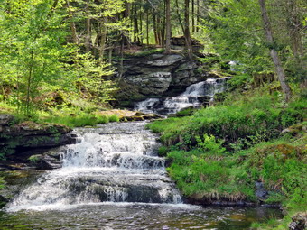 We started out at 3:05 PM with the temperature right at 82 degrees. A slight breeze was blowing but the skies were bright and sunny. We walked on Service Road toward Fox Mountain Road when a car pulled up next to us. It was Alex Rau returning home. We talked briefly and then parted. We turned left on Fox Mountain Road an walked under the Quickway. As we approached the trailhead and Benton Hollow Road, Alex returned and said that we had an ambulance call. Sheila and I got in his car so that I could go on the call with him. He took me to my car and as I got out the call was cancelled. Alex returned home and Sheila and I went back to hiking! We walked back to the intersection of Fox Mounatin Road and Benton Hollow Road and hopped the guard rail and immediately came to what was left of the trestle supports that carried the trail tracks over the stream. I noticed what remained of a painting on the trestle. I had seen this painting before but had not realized it was a memorial to NASCAR driver Davey Allison #28 who drove the Texaco-Havoline Ford car. Allison died in a helicopter crash in 1993. We walked up the trail to left to the top of the trestle. As we entered the shade of the trees, it immediately seemed a little cooler. The trail was well defined and stretched ahead for some distance. Like most rail trails it is very straight. Town of Liberty Supervisor Frank DeMayo had told me that this was state land and the town had an agreement from the state to use it during the summer. The hope is to connect the Parksville Rail Trail to all the sections that stretch as far as Livingston Manor. We started to walk along the trail and I noticed there was quite a bit of traffic on the Quickway! The land dropped off steeply to the Little Beaverkill on the right. On the left were some "cliffs" which were the result of the railroad cutting a path for the tracks. We continued to walk along the well-defined trail. It was a pleasant walk without many insects which surprised me. There were a few small blowdowns on the trail which could be removed with hand tools. I walked over or around these and removed some small branches on the trail as we walked. There are two places along the trail where there are piles of garbage. It is hard to determine why they were there. Both piles have tarps over them which seemed to indicate someone once valued the items. A VW bug was just over the bank on the right after the first pile of debris. We soon came to a gate on the trail which was odd since it was state land. No one seems to know why the gate is there or who placed it. We walked around the gate and continued on the trail. There was a path to the left just after the gate. It looked interesting but we stayed on the rail trail.
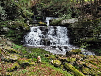 Soon we came to a small pond on the right with a red building behind it. The building looked to be in good shape but the windows were all boarded up. There was a definite path between the pond on the right and the wetlands on the left of the trail. It looked like a beaver trail to me but I could not see any dam, lodge, or even any trees that the beavers had cut. We continued to walk and I spotted some trees that the beavers had felled. The volume of the pond on the left was greatly reduced and the wetlands in the left were dying out. I thought that someone may have removed the beaver dams farther down the stream that were impounding the water. After hiking about 1.3 miles, we came to a driveway on the left which leads to the Sonoma Falls property. I knew this was private land but two town supervisors had said it was alright to visit it. At one time there was a campground on the property. Some local business people bought the property and built a cider mill and market. They took the time to construct some hiking trails along the stream. I remember that the falls were very nice with at least five separate drops which increased in height the farther upstream one ventured. The business closed when not enough people would go out of their way to visit. I took some pictures of the flowering trees on the property. We walked to the stream just behind the building and I got my first look at the falls. They had not changed much! There was a falls right in front and one visible farther upstream. I started taking the first of what would be a large number of pictures. I perched on some rocks and got a nice shot of three sets if falls. We walked the trail up to the second falls and I found a way to get a clear shot. There are several areas where there is laid up stone which made me think there had been mills along the stream at some point. We walked a little farther upstream to the third set of falls and I again found a spot where I could get some shots. We continue to walk and came to a small pond at the base of the highest falls so far. I took some wide angle shots and some that were zoomed in. The sun was at just the right angle to illuminate the falls but not to spoil the pictures. I wanted to get some shots of the upper falls so we walked up the path a short way.
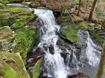 I took some shots and of the lower falls and a few of the upper. We walked back to a path that continued uphill and I thought I remembered it from visits long ago. We turned right and followed the road to a junction with another woods road. There was a sign with colored markers in red, yellow, and blue indicating the different trails. We turned right as I wanted to get to the top of the last falls. A short walk brought us to the top of the falls where there was a bridge across the stream! Beyond this was a small pond with a dam but it was marked with "No Trespassing" signs. We walked to the top of the last falls and I got out my camera to take pictures from the edge of the high bank. Sheila likes to get right to the edge and it drives me crazy. I took some pictures and the walked over to the wide, flat rocks that make ho the brink of the falls. I was careful as the rocks were wet and covered in moss. I took pictures of the brink of the falls and then some downstream. I decided not to walk down to the base of these falls. I did walk along the edge of the chasm and found a way too take some pictures of the falls. When I had exhausted all the possible shots, I packed up and walked back to bridge. I took a few pictures of the bridge and the small falls that were formed by the dam above the bridge. We turned around and continued to the sign at the trail junction. Instead of turning left to follow the trails back the way we had come, we continued straight ahead following yellow markers. The markers followed another woods road and were pretty clear until I looked ahead and could not see the anymore. I followed Sheila who seemed to be able to find the rail. We came to a point where another woods road turned left and also where I could find yellow markers. The yellow markers continued for a short distance down the hill until the woods road ended at another woods road. We had the choice of going left or right. I knew that turning left would take us back to the cider mill. I decided to turn right as I thought it might lead out to the rail trail. It wasn't very long before I found out that I was right as the path led to the rail trail at the point near the gate. This was the trail I had thought about exploring earlier! We turned right on the rail trail and began a fast-paced walk back to the car. We were back at the car at 4:45 PM having hiked 3.5 miles in 1 hour and 45 minutes with some stopped time for photography. The ascent was 330 feet almost all of which was the climb to the waterfalls. I do hope the plans to connect the sections of the rail trails are successful! I also hope that someone reopens Sonoma Falls as it is a beautiful setting.
![]()
![]()
![]()
![]() On Thursday, May 11th I had intended to get up early and do a longer hike before track practice. As often happens, my plans were changed by an early morning ambulance call. I had hoped to hike every day in May but a series of track meets, ambulance calls and church commitments interfered with that plan. By the time I got home it was 11:30 AM and I decided to again head across the street to Round Top to get some exercise with Sheila. The temperature was up to 65 degrees with bright sun, blue skies and white clouds. Sheila was quitely watching my every move but I knew she was excited as we had not been out for a couple of days. I decided to put on my light White Sierra long-sleeved crew top without a baselayer. I wore my Railriders hiking pants which are expensive but last along time and have features like deep pockets and a generous cut which I really like. The pants have Velcro closures at the ankles. I decided to put on my Keen Durand hiking boots which fit well and are newer than what I have been wearing. I added a new pair of Xstance insoles in an effort to find the best support and cushioning for my feet. These insoles have shock absorbing gel pads, TPU arch support, and memory foam cushioning all wrapped in a breathable fabric. The insoles have been hyped by their manufacturer and they really do seem to deliver. I decided to take my Leki poles with external locks as the internal twist locks sometimes fail. I chose not to don my Mammut hoody as it has too warm outside. At 12:00 PM we walked out the door to start the hike. I had grabbed Sheila's leash from the closet and we walked up the driveway. We walked across the street and to the parking lot of the Presbyterian Church. We walked behind the church to get to the road up the hill to the trailhead.
On Thursday, May 11th I had intended to get up early and do a longer hike before track practice. As often happens, my plans were changed by an early morning ambulance call. I had hoped to hike every day in May but a series of track meets, ambulance calls and church commitments interfered with that plan. By the time I got home it was 11:30 AM and I decided to again head across the street to Round Top to get some exercise with Sheila. The temperature was up to 65 degrees with bright sun, blue skies and white clouds. Sheila was quitely watching my every move but I knew she was excited as we had not been out for a couple of days. I decided to put on my light White Sierra long-sleeved crew top without a baselayer. I wore my Railriders hiking pants which are expensive but last along time and have features like deep pockets and a generous cut which I really like. The pants have Velcro closures at the ankles. I decided to put on my Keen Durand hiking boots which fit well and are newer than what I have been wearing. I added a new pair of Xstance insoles in an effort to find the best support and cushioning for my feet. These insoles have shock absorbing gel pads, TPU arch support, and memory foam cushioning all wrapped in a breathable fabric. The insoles have been hyped by their manufacturer and they really do seem to deliver. I decided to take my Leki poles with external locks as the internal twist locks sometimes fail. I chose not to don my Mammut hoody as it has too warm outside. At 12:00 PM we walked out the door to start the hike. I had grabbed Sheila's leash from the closet and we walked up the driveway. We walked across the street and to the parking lot of the Presbyterian Church. We walked behind the church to get to the road up the hill to the trailhead.
We began the ascent of the steepest hill behind the church. The hill is short but gets the circulation pumping and is the steepest and longest climb on the "trail." My goal is always to make it all the way up the hill without stopping which proved more challenging than I thought it would be. At the top of the hill we turned left and entered the woods to begin our hike. The trail was dry and there were no wet spots or muddy places to make it slippery. Just before the first trail junction, we came to the spot where a large tree had fallen across the trail. I had cut one end of the tree with my ax and saw. Brad and I had finished the job. It was almost 2 feet in diameter and we had to cut it several times to move it off the trail. At the first trail junction, I followed Sheila as she continued straight ahead up the hill toward the lookout. When we reached the top of the trail, we walked off the trail to the left to the upper viewpoint. The views down into town and across the valley to the hills was beautiful and I was a little sorry I had not brought the camera. After taking in the view, we followed the yellow trail as it headed uphill toward the next trail junction. I was already beginning to get warm and was glad I had worn the lighter top. We passed the "sitting rock" and continued on the yellow trail to the first junction with the blue trail. At the junction we Turned right and walked on the Yellow trail along the base of Round Top. At the next junction with the blue trail, we turned left and started up toward the summit. We bypassed the white crossover trail and walked over the summit to start down the other side. We again bypassed the white crossover trail but turned left on the switchback in the blue trail. The switchback took us out into the woods before turning almost 180 degrees to take us back to the main blue trail. We turned left and walked downhill to the yellow trail where we turned left. We again walked along the base of Round Top on the yellow trail. This time when we reached the trail junction we turned right to head down the trail to the woods road. We continued to follow the yellow blazes back to the first trail junction.
We turned around and walked back up the woods road to begin another figure 8. At the junction with the blue trail we turned left and walked along the base of Round Top on the yellow trail. At the trail junction with the blue trail we turned right and started up toward the summit. I had several options but decided just to do another figure 8. We turned right on the switchback and followed it out and back to the main trail. We bypassed the white crossover trail and continued on the blue trail over the summit of Round Top. On the way back down the blue trail we passed by the white crossover trail and came to the junction with the Yellow trail. We turned right and followed the yellow trail along the base of Round Top. At the next junction, we turned left and walked downhill along the yellow trail toward the viewpoint. We passed the "Sitting Rock" and continued to the lookout. We followed the yellow trail as it turned left and headed down to the first trail junction. We continued straight ahead and walked out to the trailhead where we turned right. We walked down the hill to the church parking lot. I put Sheila on her leash and we walk out to the street. We crossed the street to the driveway and walked back home. We were back at 1:15 PM after walking over two miles in 1 hour and 15 minutes.
![]()
![]()
![]()
![]() On Friday, May 5th I did not have afternoon track practice so I had planned to take a longer hike. The weather forecast was for a sunny afternoon but it was still raining in the morning when I awoke for our first ambulance call. When I returned it was still raining so I headed for the church to do some preparation for Sunday service. I spent a few hours at the church and then returned home for the next two ambulance calls. By the time we were done and I got home it was 4:00 PM. I decided just to go across the street and gain hike on Round Top. I wanted to keep my streak going even if it was a short hike. The temperature was 48 degrees as I started to get ready. Sheila was keeping a careful eye on me as I dressed. I put on my Mammut long-sleeved crew shirt without a baselayer. I wore my Railriders hiking pants which are expensive but last along time and have features like deep pockets and a generous cut which I really like. The pants have Velcro closures at the ankles. I decided to put on my Keen Durand hiking boots which fit well and are newer than what I have been wearing. I added a new pair of Xstance insoles in an effort to find the best support and cushioning for my feet. These insoles have shock absorbing gel pads, TPU arch support, and memory foam cushioning all wrapped in a breathable fabric. The insoles have been hyped by their manufacturer and they really do seem to deliver. I decided to take my Leki external lock poles as the ones with internal locks sometimes fail. I did don my Mammut hoody as it has enough zippers to dump heat if needed. I also put on a light hat. At 4:15 PM we walked out the door to start the hike. I put Sheila's leash on as we walked up the driveway. Sheila was happy to get out as we headed down the driveway and across the street. We crossed the street and walked to the parking lot next to the Presbyterian Church. We walked to the back of the church and began the ascent of the steepest hill behind the church. The hill is short but gets the circulation pumping and is the steepest and longest climb on the "trail." The skies were now cloudy with some blue patches and a lot of overcast. So far the weather had included rain, hail, wind and sun! The trees all around us were beginning to turn green and some were sporting flowers. We started on the trail by turning left at the trailhead. The trail was bare but damp in places making some areas very slippery. There were a few large puddles.
On Friday, May 5th I did not have afternoon track practice so I had planned to take a longer hike. The weather forecast was for a sunny afternoon but it was still raining in the morning when I awoke for our first ambulance call. When I returned it was still raining so I headed for the church to do some preparation for Sunday service. I spent a few hours at the church and then returned home for the next two ambulance calls. By the time we were done and I got home it was 4:00 PM. I decided just to go across the street and gain hike on Round Top. I wanted to keep my streak going even if it was a short hike. The temperature was 48 degrees as I started to get ready. Sheila was keeping a careful eye on me as I dressed. I put on my Mammut long-sleeved crew shirt without a baselayer. I wore my Railriders hiking pants which are expensive but last along time and have features like deep pockets and a generous cut which I really like. The pants have Velcro closures at the ankles. I decided to put on my Keen Durand hiking boots which fit well and are newer than what I have been wearing. I added a new pair of Xstance insoles in an effort to find the best support and cushioning for my feet. These insoles have shock absorbing gel pads, TPU arch support, and memory foam cushioning all wrapped in a breathable fabric. The insoles have been hyped by their manufacturer and they really do seem to deliver. I decided to take my Leki external lock poles as the ones with internal locks sometimes fail. I did don my Mammut hoody as it has enough zippers to dump heat if needed. I also put on a light hat. At 4:15 PM we walked out the door to start the hike. I put Sheila's leash on as we walked up the driveway. Sheila was happy to get out as we headed down the driveway and across the street. We crossed the street and walked to the parking lot next to the Presbyterian Church. We walked to the back of the church and began the ascent of the steepest hill behind the church. The hill is short but gets the circulation pumping and is the steepest and longest climb on the "trail." The skies were now cloudy with some blue patches and a lot of overcast. So far the weather had included rain, hail, wind and sun! The trees all around us were beginning to turn green and some were sporting flowers. We started on the trail by turning left at the trailhead. The trail was bare but damp in places making some areas very slippery. There were a few large puddles.
At the first trail junction, I followed Sheila as she turned right and started up the woods road which has the gentler approach of the two. There were a few branches on the trail from the winds that had passed through the area. I removed these branches either by dragging them off the trail or by using my poles on the smaller ones. It was a pleasure to walk on the trails which were now free of snow and ice. We reached the end of the woods road and turned left up the hill on the trail. We continued up the trail to the first trail junction with the upper blue trail and turned left to follow the yellow trail along the base of Round Top. There were only a few new branches here and there on the trail. I stopped to remove the branches or used my poles to flick the smaller ones aside. I was getting warmer as we hiked so I opened all the zippers on my hoody. At the next junction with the blue trail we turned right and headed up the blue trail toward the summit. When we got to the switchback, we turned right and followed it until it came back to the main blue trail. The fact that the switchback sidehills in places made the walk a little more difficult. We turned right and then continued straight ahead and up the hill toward the summit of Round Top bypassing the white crossover trail. We continued over the summit and down the blue trail toward the junction with the yellow trail. We bypassed the white crossover trail again and continued down to the yellow trail. At the junction with the yellow trail we turned right and walked the yellow trail along the base of Round Top to the next junction with the blue trail. We turned left and started slightly downhill toward the lookout over town. We followed the yellow trail as it turned left and descended the steep hill back to the first trail junction. The descent went quickly even though the leaves were damp and slippery. When we got to the first trail junction, I checked my watch. I decided we would return home as supper would be ready and the rain had returned. It was 5:00 PM and we had hiked a little over 1 mile in 45 minutes.
![]()
![]()
![]()
![]() On Thursday, May 4th I had intended to get up early and do a longer hike before track practice. As often happens, my plans were changed by an early morning ambulance call. When I returned from the call, I got a few more hours of sleep. I finally got up at 9:00 AM and did some work for church and for the ambulance corps. I finished what I needed to accomplish by 11:00 AM and contemplated where I could go for a shorter hike. I decided I wanted to go across the street to Round Top to get some exercise with Sheila. The temperature was up to 48 degrees but there was still some rain in the air. I decided to continue my recently instituted "No Excuses" policy. Sheila was quitely watching my every move but I knew she was excited as we had not been out for a couple of days. I decided to put on my Mammut crew top without a baselayer. I wore my Railriders hiking pants which are expensive but last along time and have features like deep pockets and a generous cut which I really like. The pants have Velcro closures at the ankles. I decided to put on my Keen Durand hiking boots which fit well and are newer than what I have been wearing. I added a new pair of Xstance insoles in an effort to find the best support and cushioning for my feet. These insoles have shock absorbing gel pads, TPU arch support, and memory foam cushioning all wrapped in a breathable fabric. The insoles have been hyped by their manufacturer and they really do seem to deliver. I decided to take my Leki poles with external locks as the internal twist locks sometimes fail. I did don my Mammut hoody as it has enough zippers to dump heat if needed. The hoody is also at least partly water resistant. I put on a light hat. At 11:35 PM we walked out the door to start the hike. I looked around and saw the sky was overcast with some dark clouds. There was also a light rain falling. I grabbed Sheila's leash from the car and we walked up the driveway. We walked across the street and to the parking lot of the Presbyterian Church. We walked behind the church to get to the road up the hill to the trailhead.
On Thursday, May 4th I had intended to get up early and do a longer hike before track practice. As often happens, my plans were changed by an early morning ambulance call. When I returned from the call, I got a few more hours of sleep. I finally got up at 9:00 AM and did some work for church and for the ambulance corps. I finished what I needed to accomplish by 11:00 AM and contemplated where I could go for a shorter hike. I decided I wanted to go across the street to Round Top to get some exercise with Sheila. The temperature was up to 48 degrees but there was still some rain in the air. I decided to continue my recently instituted "No Excuses" policy. Sheila was quitely watching my every move but I knew she was excited as we had not been out for a couple of days. I decided to put on my Mammut crew top without a baselayer. I wore my Railriders hiking pants which are expensive but last along time and have features like deep pockets and a generous cut which I really like. The pants have Velcro closures at the ankles. I decided to put on my Keen Durand hiking boots which fit well and are newer than what I have been wearing. I added a new pair of Xstance insoles in an effort to find the best support and cushioning for my feet. These insoles have shock absorbing gel pads, TPU arch support, and memory foam cushioning all wrapped in a breathable fabric. The insoles have been hyped by their manufacturer and they really do seem to deliver. I decided to take my Leki poles with external locks as the internal twist locks sometimes fail. I did don my Mammut hoody as it has enough zippers to dump heat if needed. The hoody is also at least partly water resistant. I put on a light hat. At 11:35 PM we walked out the door to start the hike. I looked around and saw the sky was overcast with some dark clouds. There was also a light rain falling. I grabbed Sheila's leash from the car and we walked up the driveway. We walked across the street and to the parking lot of the Presbyterian Church. We walked behind the church to get to the road up the hill to the trailhead.
We began the ascent of the steepest hill behind the church. The hill is short but gets the circulation pumping and is the steepest and longest climb on the "trail." My goal is always to make it all the way up the hill without stopping which proved more challenging than I thought it would be. At the top of the hill we stopped so that I could take a look around. Directly across the valley from Round Top is Beer Mountain next to the Upward Brewery. I reminded myself that I should go and hike there sometime. We turned left and entered the woods to begin our hike. The trail was wet and muddy in places which made it slippery. Just before the first trail junction, we came to the spot where a large tree had fallen across the trail. I had cut one end of the tree with my ax and saw. Brad and I had finished the job. It was almost 2 feet in diameter and we had to cut it several times to move it off the trail. At the first trail junction, I followed Sheila as she continued straight ahead up the hill toward the lookout. When we reached the top of the trail, we walked off the trail to the left to the upper viewpoint. The views down into town and across the valley to the hills were poor due to the mist and rain that was falling. After taking in the view, we followed the yellow trail as it headed uphill toward the next trail junction. I was already beginning to get warm so I stopped and opened all the zippers I could. We passed the "sitting rock" and continued on the yellow trail to the first junction with the blue trail. At the junction we continued straight ahead up the blue trail. When we reached the switchback in the blue trail, I decided to continue straight up to the summit. We also bypassed the white crossover trail on the way. At the summit there was a muddy puddle which was easy to avoid. Some of the trees along the trail were leaning into the trail and I knew they would require some trimming. We walked down the blue trail bypassing the white crossover trail. At the junction with the blue trail, we continued straight ahead on the yellow trail. We walked down to the woods road and continued out to the first trail junction to complete a big loop.
We turned around and walked back up the woods road to begin another large loop. At the junction with the blue trail we continue straight up to the summit bypassing the white crossover trail. The sun had come out and the rain had stopped falling which elevated my mood. We started down the other side and I again decided to go straight down the blue trail. We bypassed the white crossover trail and the switchback in the blue trail. At the junction with the yellow trail we continued straight ahead on the yellow trail. We walked downhill passed the "Sitting Rock" to the overlook. We followed the yellow trail as it turned left and headed down to the first trail junction.It had started to rain again but I decided we would do at least one small loop. We turned around and headed back up to the viewpoint. We followed the yellow trail as it turned right and headed up to the junction with the blue rail. We turned right here and walked along the base of Round Top on the yellow trail. At the junction with the blue trail we turned right and headed down the yellow trail. We hit the woods road and continued down to the first trail junction. By now I was pretty wet so I decided we would return home. We turned left and walked out to the trailhead where we turned right. We walked down the hill to the church parking lot. I put Sheila on her leash and we walk out to the street. We crossed the street to the driveway and walked back home. We were back at 12:45 PM after walking a little over two miles in 1 hour and 10 minutes.
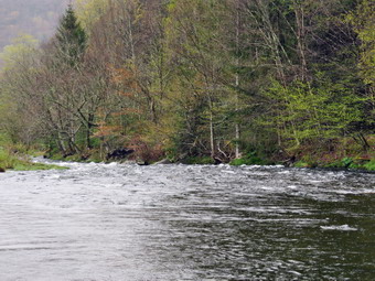
![]()
![]()
![]()
![]()
![]() On Wednesday, May 3rd, I wanted to extend my days of consecutive hikes to three. This may not seem like much but my excuses piled up in April so that I only got in 4 days of hiking. I decided I had to correct this problem and make room in my schedule for as many walks and hikes as I could. Getting away even for an hour improves my mood and my physical health. When I got up it was raining and 40 degrees and I knew the day would not get much better. I called the girls track coach and we decided to postpone the track meet to another day. This gave me some leeway to schedule a hike. I had gone on one ambulance call in the evening and one in the early morning and hoped there would not be another until I got back from hiking. At 1:00 PM the sky was overcast and there were some rain drops falling, I decided to get out and not make excuses even though the temperature was 45 degrees! I chose to go to the Beaverkill Campgrounds to hike along the river. The campground is closed and I thought it would be quiet. I also hoped the recent rain would have increased the level of the Beaverkill to make for some interesting pictures. I started to get ready at 1:00 PM with the temperature at 46 degrees. Sheila certainly was happy to go hiking anywhere at any time. I put on my Mammut long-sleeved crew shirt without a baselayer. I wore my Railriders hiking pants which are expensive but last along time and have features like deep pockets and a generous cut which I really like. The pants have Velcro closures at the ankles. I decided to put on my Keen Durand hiking boots which fit well and are newer than what I have been wearing. I added a new pair of Xstance insoles in an effort to find the best support and cushioning for my feet. These insoles have shock absorbing gel pads, TPU arch support, and memory foam cushioning all wrapped in a breathable fabric. The insoles have been hyped by their manufacturer and they really do seem to deliver. I decided to take my Leki poles with external locks as the internal twist locks sometimes fail. I did don my Mammut hoody as it has enough zippers to dump heat if needed. I wore my OR Crocodile gaiters in case there was any show or mud. I did put on a light hat. We left the house at 1:15 PM as I drove out Old Route 17 toward Roscoe and turned right on Beaverkill Road. As I drove up Johnson Mountain the rain began to fall and I wondered if I had the motivation to hike and get wet. As we started the descent into the Beaverkill Valley, I turned left on Campsite Road and followed it down to the parking area near the Beaverkill Covered Bridge. There was one car parked in the lot and that was a fisherman. A glance at the river showed that the level was high enough to be interesting. The temperature was 39 degrees and the light rain continued to fall.
On Wednesday, May 3rd, I wanted to extend my days of consecutive hikes to three. This may not seem like much but my excuses piled up in April so that I only got in 4 days of hiking. I decided I had to correct this problem and make room in my schedule for as many walks and hikes as I could. Getting away even for an hour improves my mood and my physical health. When I got up it was raining and 40 degrees and I knew the day would not get much better. I called the girls track coach and we decided to postpone the track meet to another day. This gave me some leeway to schedule a hike. I had gone on one ambulance call in the evening and one in the early morning and hoped there would not be another until I got back from hiking. At 1:00 PM the sky was overcast and there were some rain drops falling, I decided to get out and not make excuses even though the temperature was 45 degrees! I chose to go to the Beaverkill Campgrounds to hike along the river. The campground is closed and I thought it would be quiet. I also hoped the recent rain would have increased the level of the Beaverkill to make for some interesting pictures. I started to get ready at 1:00 PM with the temperature at 46 degrees. Sheila certainly was happy to go hiking anywhere at any time. I put on my Mammut long-sleeved crew shirt without a baselayer. I wore my Railriders hiking pants which are expensive but last along time and have features like deep pockets and a generous cut which I really like. The pants have Velcro closures at the ankles. I decided to put on my Keen Durand hiking boots which fit well and are newer than what I have been wearing. I added a new pair of Xstance insoles in an effort to find the best support and cushioning for my feet. These insoles have shock absorbing gel pads, TPU arch support, and memory foam cushioning all wrapped in a breathable fabric. The insoles have been hyped by their manufacturer and they really do seem to deliver. I decided to take my Leki poles with external locks as the internal twist locks sometimes fail. I did don my Mammut hoody as it has enough zippers to dump heat if needed. I wore my OR Crocodile gaiters in case there was any show or mud. I did put on a light hat. We left the house at 1:15 PM as I drove out Old Route 17 toward Roscoe and turned right on Beaverkill Road. As I drove up Johnson Mountain the rain began to fall and I wondered if I had the motivation to hike and get wet. As we started the descent into the Beaverkill Valley, I turned left on Campsite Road and followed it down to the parking area near the Beaverkill Covered Bridge. There was one car parked in the lot and that was a fisherman. A glance at the river showed that the level was high enough to be interesting. The temperature was 39 degrees and the light rain continued to fall.
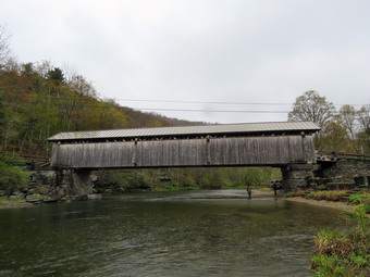 I got out my camera and walked over to the river with Sheila right behind me. The river was high but I was able to get to a spit of land where I could take a few shots of the bridge and the river. The river is deep in this area so there were no whitecaps as there were downstream. After taking my sots, we returned to the car where I stowed my camera. It was still cold and raining. I decided we would just walk along the near side of the river to a large stone bench and them return. I did not take my pack as I did not want it to get wet and I did not intend to get my camera out again. We walked the length of the parking lot and passed a gate. Just after the gate was some concrete pavement which seemed to be in an odd spot. I remember when an arm of the river flowed across this area and access to the campsites was by driving your car through the water. The concrete ford helped support the cars! As we walked along a woods road that paralleled the river, I was pleased to see that all of the blowdowns that had fallen were now cut and cleaned up. The tall grass was mowed. We walked along the river to the large stone bench where and area had been mowed and some picnic tables had been added. We took a slightly different route back which had also been cleared. We walked back to the car after only about 15 minutes. It was still raining but I decided we would walk to the other side the river and turn around after hiking a short distance. I again left my pack in the car knowing I might regret not having my camera. We walked out of the parking lot to the bridge and crossed over to the other side. When we got to the other side, the gate just off the road was closed as the campgrounds were closed. I looked at the trail and saw that it was wet but that there were no large puddles. We turned left on a woods road that parallels the river and started down a short hill. We passed the spring house and continued on the deserted woods road. The water was filled with duck weed which was very green. We came to the area where a little path down to the river but there was no reason for me to go down to the river so we continued on the road. We passed several areas with unused picnic tables looking the worse for wear. Several picnic tables sat unused and rotting along the road, a testimony to better days. We walked by these tables which had not been used in many years. A little later we came to what was once a bathroom for some campsites that had long since disappeared. Further along on the road, there was another area with more picnic tables. There was a path over to the river so I walked over and found the water was churning and full of whitecaps. I wished that I had brought my camera as the rain had now almost stopped. I made due with enjoying the view before returning to the road.
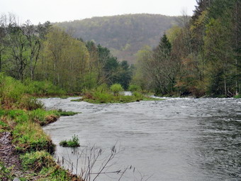 We continued on and at about .7 miles the woods road met the paved road that serves the campsites. This area was wet and a little slippery but we continued on the road through the campsites along the river. It was obvious that the crew responsible for the campsite had been at work cutting up blowdowns and removing smaller branches ROM the roads. The campsites completely empty and the picture of solitude. We walked to the last campsite where the road ends and Sheila and I walked down to the edge of the river. I was careful to watch where I was walking as the water was a little high and looked cold. Sheila also avoided the cold clear water. I stopped to take a look upstream where there were some whitecaps on downstream where the river goes around a bend. We continued along the shore a little further passed the last campsite and then walked back up to the road. We started back to the car staying to the left of the last bathroom to walk back on the other paved road through the campsites. This road parallels the one we walked out on to make a sort of loop. We continued back on the same woods road we had walked out on at a much faster pace. We walked through the bridge and turned right to go back to the car. There were now two other cars in the lot but we did not see any people. We were back to the car at 2:30 PM having hiked 2.8 miles in an hour we very little gain in elevation. On the drive back to town the rain began to fall again.
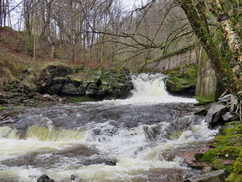
![]()
![]()
![]()
![]()
![]() On Tuesday, May 2nd I wanted to get out for a hike before track practice. When I got up at 7:00 AM the temperature was 40 degrees and it was raining. I decided to wait to see if the rain stopped. In addition, I was one of the only EMTs around to respond on calls. As luck would have it a call came in and we responded to the Roscoe Nursing Home. I returned home at 11:00 AM. The skies were still overcast and I had a nagging cold but I was tired of making excuses. I began to get ready to go with drizzle in the air and overcast skies wit the raptures at 47 degrees. I asked Cindy if she would like to hike the Parksville Rail Trail and she declined. The hike is about 2.5 miles and I was hoping the falls would be flowing freely from the recent rains as they are beautiful. I started to get ready at 11:05 AM with Sheila showing her excitement. We had hiked the day before but as I was getting dressed it looked as if she thought we might not hike again! I put on my Mammut long-sleeved crew shirt without a baselayer. I wore my Railriders hiking pants which are expensive but last along time and have features like deep pockets and a generous cut which I really like. The pants have Velcro closures at the ankles. I decided to put on my Keen Durand hiking boots which fit well and are newer than what I have been wearing. I added a new pair of Xstance insoles in an effort to find the best support and cushioning for my feet. These insoles have shock absorbing gel pads, TPU arch support, and memory foam cushioning all wrapped in a breathable fabric. The insoles have been hyped by their manufacturer and they really do seem to deliver. I decided to take my Leki poles with external locks as the internal twist locks sometimes fail. I did don my Mammut hoody as it has enough zippers to dump heat if needed. I wore my OR Crocodile gaiters in case there was any show or mud. I did put on a light hat. At 11:20 AM I put my gear in the car and Sheila in the back seat and headed out Old Route 17 and drove across the Flats. I took Old Route 17 and Service Road to the point where they meet Fox Mountain Road. There were no vehicles in the parking lot which was as I expected because of the weather.
On Tuesday, May 2nd I wanted to get out for a hike before track practice. When I got up at 7:00 AM the temperature was 40 degrees and it was raining. I decided to wait to see if the rain stopped. In addition, I was one of the only EMTs around to respond on calls. As luck would have it a call came in and we responded to the Roscoe Nursing Home. I returned home at 11:00 AM. The skies were still overcast and I had a nagging cold but I was tired of making excuses. I began to get ready to go with drizzle in the air and overcast skies wit the raptures at 47 degrees. I asked Cindy if she would like to hike the Parksville Rail Trail and she declined. The hike is about 2.5 miles and I was hoping the falls would be flowing freely from the recent rains as they are beautiful. I started to get ready at 11:05 AM with Sheila showing her excitement. We had hiked the day before but as I was getting dressed it looked as if she thought we might not hike again! I put on my Mammut long-sleeved crew shirt without a baselayer. I wore my Railriders hiking pants which are expensive but last along time and have features like deep pockets and a generous cut which I really like. The pants have Velcro closures at the ankles. I decided to put on my Keen Durand hiking boots which fit well and are newer than what I have been wearing. I added a new pair of Xstance insoles in an effort to find the best support and cushioning for my feet. These insoles have shock absorbing gel pads, TPU arch support, and memory foam cushioning all wrapped in a breathable fabric. The insoles have been hyped by their manufacturer and they really do seem to deliver. I decided to take my Leki poles with external locks as the internal twist locks sometimes fail. I did don my Mammut hoody as it has enough zippers to dump heat if needed. I wore my OR Crocodile gaiters in case there was any show or mud. I did put on a light hat. At 11:20 AM I put my gear in the car and Sheila in the back seat and headed out Old Route 17 and drove across the Flats. I took Old Route 17 and Service Road to the point where they meet Fox Mountain Road. There were no vehicles in the parking lot which was as I expected because of the weather.
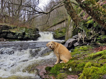 We started out on the trail at 11:35 AM PM with the temperature at 48 degrees under overcast skies and some drizzle in the air. The open trail just before the woods was drier than I expected after several days of rain. Usually as we enter the trees the temperature seems to drop but on this day there was not much change except some protection from the rain. We immediately ran into some puddles but I was able to walk along the side of the trail without any problems. We passed a medium-sized trunk that had been across the trail but Brad and I had cleared it completely. One look down to the Little Beaverkill showed the stream volume was high and the water was slightly muddy. I wondered about the condition of the falls and whether they would be frozen or not. Sheila was taking her own route and following her nose and getting very close to the edge of the trail where a steep drop led down to the river! We came across another place where there had been a blowdown that Brad and I had removed with hand tools. We were soon at the wooden walkways and I decided I would skip the pictures until we got to the falls. We continued over the wooden walkways and bridges taking our time as they were very slippery from several days of rain. I thought I might suggest to the Town of Liberty that some hardware cloth be placed OM the walkways to improve the grip. This time the water from the small stream was actually flowing through the culvert under the bridge. After crossing the bridge, we continued at a fast pace as the rain showers continue. As we walked along the trail we found a few more blowdowns that Brad and I had cleared. At this point there was quite a bit of water on the trail but it was not deep and I either walked through it or around. Sheila was not phased by the water and simply walked through the bubbles. As we approached the falls, we could hear the sound of the falls roaring.
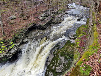 We arrived at the falls at 11:55 AM, we found that there was an incredible flow of water. I immediately started down the path to the stream. The path was wet and a little slippery but Sheila and I both negotiated our way down to the streambed. I set down my pack to get out my camera. I positioned myself and took pictures of the falls and the rapids below. I also took some shots downstream before shooting a few more of the falls. Sheila sat in a rock and I took some shots of her posing. When I was done, I put the camera back in my pack, shouldered the pack, and climbed up the path to the main trail. I once again got out my camera and took some more shots of the falls from above. I also took some pictures of the stream above the falls. I packed up and decided I had enough time to continue to Parksville. I decided to continue the hike on the trail but walked by the bench where a path leads down to the stream. This area was not that interesting and I just wanted to walk. We found more and more water on the trail extending across the entire width of the trail. The water was easy enough to avoid so we continued on to the end of the trail. As we approached the end of the trail, hail began to fall. The hail soon turned to hail and rain and them all rain. We immediately turned around at 12:10 PM and started back to the car. The rain continued until we passed the falls when it let up and eventually ended. I put my head down and decided I did not need any more pictures. We made quick work of the rest of the trail. We were back at the car at 12:35 PM after hiking about 2.6 miles in 1 hour! This time was much quicker than I expected and even included the time to take pictures. there is virtually no elevation gain on the hike.
![]()
![]()
![]()
![]() On Monday, May 1st I planned to get out for a hike before afternoon track practice. April was my worst month for hiking ever due to ambulance calls, track meets, weather and church work; not necessarily in that order. I am trying to rearrange my schedule so I can get out more often and for longer hikes. On this morning I was out on an ambulance call in Liberty at 5:30 AM and another in Roscoe at 11:00 AM. When I got home from the second call, I found that my grandson Lukas was at the house. He had not felt well enough to go to school in the morning but was now ready to go on a hike. The temperature was 48 degrees when we decided to go across the street to Round Top. Sheila and I had not been out for almost two weeks due so she was more than ready to go. She was keeping a careful eye on me as I dressed. I put on my Mammut long-sleeved crew shirt without a baselayer. I wore my Railriders hiking pants which are expensive but last along time and have features like deep pockets and a generous cut which I really like. The pants have Velcro closures at the ankles. I had on my Vasque Talus hiking boots which fit well but have a minimal replacement insole. I decided to take my Leki external lock poles as the ones with internal locks sometimes fail. I did don my Mammut hoody as it has enough zippers to dump heat if needed. I also put on a light hat. At 12:25 PM we walked out the door to start the hike. I gave Lukas Sheila's leash and he put it on her as we walked up the driveway. I aimed to hike for about an hour depending on how difficult the slippery terrain might be from the rain from the day before. Sheila was happy to get out as we headed down the driveway and across the street with Lukas trying to stay with her. We crossed the street and walked to the parking lot next to the Presbyterian Church. We walked to the back of the church and began the ascent of the steepest hill behind the church. The hill is short but gets the circulation pumping and is the steepest and longest climb on the "trail." Even though I had not been hiking much, I made it to the top without stopping. We noticed another hiker and his dog ahead of us on the road. The hiker and the dog turned left onto the trail as we were coming up the hill. At the top of the hill we paused for a minute so I could look around at the hills that surround the hamlet of Livingston Manor. The skies were cloudy with some blue patches and some sun with a few white clouds. So far the weather had included rain, hail, wind and sun! The trees all around us were beginning to turn green and some were sporting flowers. I had decided not to bring my pack just to carry my camera. I was a little sorry I did not have the camera as there were some good photographic opportunities. I stopped to talk to the workers digging a grave in the cemetery and then continued the hike We started on the trail by turning left at the trailhead. The trail was bare but damp in places making some areas very slippery. There were a few large puddles.
On Monday, May 1st I planned to get out for a hike before afternoon track practice. April was my worst month for hiking ever due to ambulance calls, track meets, weather and church work; not necessarily in that order. I am trying to rearrange my schedule so I can get out more often and for longer hikes. On this morning I was out on an ambulance call in Liberty at 5:30 AM and another in Roscoe at 11:00 AM. When I got home from the second call, I found that my grandson Lukas was at the house. He had not felt well enough to go to school in the morning but was now ready to go on a hike. The temperature was 48 degrees when we decided to go across the street to Round Top. Sheila and I had not been out for almost two weeks due so she was more than ready to go. She was keeping a careful eye on me as I dressed. I put on my Mammut long-sleeved crew shirt without a baselayer. I wore my Railriders hiking pants which are expensive but last along time and have features like deep pockets and a generous cut which I really like. The pants have Velcro closures at the ankles. I had on my Vasque Talus hiking boots which fit well but have a minimal replacement insole. I decided to take my Leki external lock poles as the ones with internal locks sometimes fail. I did don my Mammut hoody as it has enough zippers to dump heat if needed. I also put on a light hat. At 12:25 PM we walked out the door to start the hike. I gave Lukas Sheila's leash and he put it on her as we walked up the driveway. I aimed to hike for about an hour depending on how difficult the slippery terrain might be from the rain from the day before. Sheila was happy to get out as we headed down the driveway and across the street with Lukas trying to stay with her. We crossed the street and walked to the parking lot next to the Presbyterian Church. We walked to the back of the church and began the ascent of the steepest hill behind the church. The hill is short but gets the circulation pumping and is the steepest and longest climb on the "trail." Even though I had not been hiking much, I made it to the top without stopping. We noticed another hiker and his dog ahead of us on the road. The hiker and the dog turned left onto the trail as we were coming up the hill. At the top of the hill we paused for a minute so I could look around at the hills that surround the hamlet of Livingston Manor. The skies were cloudy with some blue patches and some sun with a few white clouds. So far the weather had included rain, hail, wind and sun! The trees all around us were beginning to turn green and some were sporting flowers. I had decided not to bring my pack just to carry my camera. I was a little sorry I did not have the camera as there were some good photographic opportunities. I stopped to talk to the workers digging a grave in the cemetery and then continued the hike We started on the trail by turning left at the trailhead. The trail was bare but damp in places making some areas very slippery. There were a few large puddles.
At the first trail junction, we followed Sheila as she turned right and started up the woods road which has the gentler approach of the two. There were a few branches on the trail from the winds that had passed through the area. I removed these branches either by dragging them off the trail or by using my poles on the smaller ones. It was a pleasure to walk on the trails which were now free of snow and ice. We reached the end of the woods road and turned left up the hill on the trail. I pointed out the frame and tarps that covered the mouth of one of the "caves" To Lukas. They were looking ragged as if no one had used them for some time. We continued up the trail to the first trail junction with the upper blue trail and turned left to follow the yellow trail along the base of Round Top. There were only a few new branches here and there on the trail. I stopped to remove the branches or used my poles to flick the smaller ones aside. I was getting warmer as we hiked so I opened all the zippers on my hoody. At the next junction with the blue trail we turned right and headed up the blue trail toward the summit. When we got to the switchback, we turned right and followed it until it came back to the main blue trail. The fact that the switchback sidehills in places made the walk a little more difficult. We turned right and then continued straight ahead and up the hill toward the summit of Round Top bypassing the white crossover trail. As we walked over the high point, Lukas removed a couple of branches off the trail. We continued over the summit and down the blue trail toward the junction with the yellow trail. We bypassed the white crossover trail again and continued down to the yellow trail. At the junction with the yellow trail we turned right and walked the yellow trail along the base of Round Top to the next junction with the blue trail. We turned left and started slightly downhill toward the lookout over town.
Again, I regretted leaving my camera home as there were some pretty views down to town and the school from the viewpoint. There were also some nice views of the hills around town. We followed the yellow trail as it turned left and descended the steep hill back to the first trail junction. The descent went quickly even though the leaves were damp and slippery. When we got to the first trail junction, I checked my watch. I decided we had time to turn around to do another loop. Sheila seemed pleased as she dashed ahead of us up the hill. For me, the ascent was definitely more difficult than the descent! At the top of the hill we followed the trail as it turned right and headed uphill toward the junction with the blue trail. We hiked up a short but steep little hill and arrived at the trail junction. We turned right to follow the trail along the base of Round Top. Sheila was some distance ahead when she came roaring back at me at full speed. She passed me, made a 180 degree turn, and came running back. She repeated this several times before I called her off. At the next junction with the blue trail we turned left and walked the blue trail toward the summit. We turned left at the white crossover tail as I wanted to check the blowdowns on all the trails. There was one large branch that was partly blocking the trail. I asked Lukas to drag the large branch off the trail and he did a great job of removing the obstruction. There were a few other places that needed some trimming. At the main blue trail we turned left and then left again on the switchback. We followed it out into the forest and then back to the main trail. We turned left and walked downhill to the yellow trail where a left turn again took us along the base of Round Top. At the junction, we turned right and walked down the trail to the woods road. We followed the woods road downhill with the ledges to the right. At the first trail junction, we turned left and walked straight out to the trailhead. We turned right and walked downhill crossing the road and walking through the church parking lot. We waited to cross the road as several cars went by and then crossed to the driveway to the house. It was 1:35 PM and we had hiked a little over 2 miles in a an hour and 10 minutes.
![]()
![]()
![]()
![]() On Tuesday, April 18th I planned to get out for a hike before afternoon track practice. The temperature when I got up ay 7:00 AM was only 38 degrees so I decided to wait some time before going across the street to Round Top. Sheila and I had not been out for a week due to a brutal string and ambulance calls and my usual commitments to the track team. When I checked the thermometer at 11:30 AM it was 47 degrees. Sheila was ready to go as she really likes to hike and we had not been out for a few days. She was keeping a careful eye on me as I dressed. I put on my Mammut long-sleeved crew shirt without a baselayer. I wore my Railriders hiking pants which are expensive but last along time and have features like deep pockets and a generous cut which I really like. The pants have Velcro closures at the ankles. I decided to put on my Keen Durand hiking boots which fit well and are newer than what I have been wearing. I added a new pair of Xstance insoles in an effort to find the best support and cushioning for my feet. These insoles have shock absorbing gel pads, TPU arch support, and memory foam cushioning all wrapped in a breathable fabric. The insoles have been hyped by their manufacturer and they really do seem to deliver. I decided to take my Leki external lock poles as the ones with internal locks sometimes fail. I did don my Mammut hoody as it has enough zippers to dump heat if needed. I put on a light hat and put a pair of light gloves in my pocket. At 11:50 AM we walked out the door to start the hike. I grabbed Sheila's leash from the car and put it on her as we walked up the driveway. I aimed to hike for about an hour depending on how difficult the slippery terrain might be. Sheila was happy to get out as we headed down the driveway and across the street with me trying to stay on the snow covered surfaces. We crossed the street and walked to the parking lot next to the Presbyterian Church. We walked to the back of the church and began the ascent of the steepest hill behind the church. The hill is short but gets the circulation pumping and is the steepest and longest climb on the "trail." Even though I had not been hiking much, I made it to the top without stopping. At the top of the hill we paused for a minute so I could look around at the hills that surround the hamlet of Livingston Manor. The skies were cloudy with some blue patches and some sun with a few white clouds. The trees all around us were beginning to turn green and some were sporting flowers. I had decided not to bring my pack just to carry my camera. I was a little sorry I did not have the camera as there were some good photographic opportunities. We started on the trail by turning left at the trailhead. The trail was bare but damp in places making some areas very slippery.
On Tuesday, April 18th I planned to get out for a hike before afternoon track practice. The temperature when I got up ay 7:00 AM was only 38 degrees so I decided to wait some time before going across the street to Round Top. Sheila and I had not been out for a week due to a brutal string and ambulance calls and my usual commitments to the track team. When I checked the thermometer at 11:30 AM it was 47 degrees. Sheila was ready to go as she really likes to hike and we had not been out for a few days. She was keeping a careful eye on me as I dressed. I put on my Mammut long-sleeved crew shirt without a baselayer. I wore my Railriders hiking pants which are expensive but last along time and have features like deep pockets and a generous cut which I really like. The pants have Velcro closures at the ankles. I decided to put on my Keen Durand hiking boots which fit well and are newer than what I have been wearing. I added a new pair of Xstance insoles in an effort to find the best support and cushioning for my feet. These insoles have shock absorbing gel pads, TPU arch support, and memory foam cushioning all wrapped in a breathable fabric. The insoles have been hyped by their manufacturer and they really do seem to deliver. I decided to take my Leki external lock poles as the ones with internal locks sometimes fail. I did don my Mammut hoody as it has enough zippers to dump heat if needed. I put on a light hat and put a pair of light gloves in my pocket. At 11:50 AM we walked out the door to start the hike. I grabbed Sheila's leash from the car and put it on her as we walked up the driveway. I aimed to hike for about an hour depending on how difficult the slippery terrain might be. Sheila was happy to get out as we headed down the driveway and across the street with me trying to stay on the snow covered surfaces. We crossed the street and walked to the parking lot next to the Presbyterian Church. We walked to the back of the church and began the ascent of the steepest hill behind the church. The hill is short but gets the circulation pumping and is the steepest and longest climb on the "trail." Even though I had not been hiking much, I made it to the top without stopping. At the top of the hill we paused for a minute so I could look around at the hills that surround the hamlet of Livingston Manor. The skies were cloudy with some blue patches and some sun with a few white clouds. The trees all around us were beginning to turn green and some were sporting flowers. I had decided not to bring my pack just to carry my camera. I was a little sorry I did not have the camera as there were some good photographic opportunities. We started on the trail by turning left at the trailhead. The trail was bare but damp in places making some areas very slippery.
At the first trail junction, I followed Sheila as she turned right and started up the woods road which has the gentler approach of the two. There were a few branches on the trail from the winds that had passed through the area. I removed these branches either by dragging them off the trail or by using my poles on the smaller ones. It was a pleasure to walk on the trails which were now free of snow and ice. We reached the end of the woods road and turned left up the hill on the trail. The frame and tarps that covered the mouth of one of the "caves" were looking ragged as if no one had used them for some time. We continued up the trail to the first trail junction with the upper blue trail and turned left to follow the yellow trail along the base of Round Top. There were only a few new branches here and there on the trail. I stopped to remove the branches or used my poles to flick the smaller ones aside. I was getting warmer as we hiked so I opened all the zippers on my hoody. At the next junction with the blue trail we turned right and headed up the blue trail toward the summit. When we got to the switchback, we turned right and followed it until it came back to the main blue trail. The fact that the switchback sidehills in places made the walk a little more difficult. We turned right and then continued straight ahead and up the hill toward the summit of Round Top bypassing the white crossover trail. As we walked over the high point, I moved a couple of large branches and trunks off the trail. We continued over the summit and down the blue trail toward the junction with the yellow trail. We bypassed the white crossover trail again and continued down to the yellow trail. At the junction with the yellow trail we turned right and walked the yellow trail along the base of Round Top to the next junction with the blue trail. We turned left and started slightly downhill toward the lookout over town.
Again, I regretted leaving my camera home as there were some pretty views down to town and the school from the viewpoint. There were also some nice views of the hills around town. We followed the yellow trail as it turned left and descended the steep hill back to the first trail junction. The descent went quickly even though the leaves were damp and slippery. When we got to the first trail junction, I checked my watch and it was 12:20 PM. I decided I had time to turn around to do another loop. Sheila seemed pleased as she dashed ahead of me up the hill. For me, the ascent was definitely more difficult than the descent! At the top of the hill we followed the trail as it turned right and headed uphill toward the junction with the blue trail. We hiked up a short but steep little hill and arrived at the trail junction. We turned right to follow the trail along the base of Round Top. Sheila was some distance ahead when she came roaring back at me at full speed. She passed me, made a 180 degree turn, and came running back. She repeated this several times before I called her off. At the next junction with the blue trail we turned left and walked the blue trail toward the summit. We turned left at the white crossover tail as I wanted to check the blowdowns on all the trails. I didn't find much blocking the trail and at the main blue trail we turned left and then left again on the switchback. We followed it out into the forest and then back to the main trail. We turned left and walked downhill to the yellow trail where a left turn again took us along the base of Round Top. At the junction, we turned right and walked down the trail to the woods road. We followed the woods road downhill with the ledges to the right. At the first trail junction, we turned left and walked straight out to the trailhead. We turned right and walked downhill crossing the road and walking through the church parking lot. We waited to cross the road as several cars went by and then crossed to the driveway to the house. It was 1:00 PM and we had hiked a little over 2 miles in a an hour and 10 minutes. My legs were now pretty sore but I was glad we got to hike.
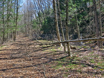
![]()
![]()
![]()
![]()
![]() On Monday, April 10th I wanted to get out to clear the blowdowns on the Parksville Rail Trail. I had talked to the Town of Liberty Supervisor Frank DeMayo who gave me permission to do the work. He did not know and he could not tell me who was responsible for clearing the rail trail. My son-in-law Brad was at our house for spring break and I knew his help would be invaluable in doing the work. I had hoped to start early but three overnight ambulance calls stood in the way! When we returned from the last call at 7:00 AM the temperature was 45 degrees but the forecast was for highs in the 60s. Brad and I decided to see if we could get some more rest. I fell asleep quickly and woke up at 11:00 AM with bright blue skies and plenty of sun with the thermometer reading 55 degrees. We ate lunch and then started to get ready at 12:45 PM. We knew the trail might be wet and muddy but I hoped most of the snow and ice would be gone. The hike is about 2.5 miles band I was hoping the falls would be flowing nicely. I did not intend to go further than the falls as there were no blowdowns after that. Sheila could not contain her excitement as we were getting dressed as if she thought we might not hike again! I put on my Mammut long-sleeved crew shirt without a baselayer. I wore my Railriders hiking pants which are expensive but last along time and have features like deep pockets and a generous cut which I really like. The pants have Velcro closures at the ankles. I decided to put on my Keen Durand hiking boots which fit well and are newer than what I have been wearing. I added a new pair of Xstance insoles in an effort to find the best support and cushioning for my feet. These insoles have shock absorbing gel pads, TPU arch support, and memory foam cushioning all wrapped in a breathable fabric. The insoles have been hyped by their manufacturer and they really do seem to deliver. I decided to leave my Leki poles behind as we would be carrying tools to clear the rail. I did don my Mammut hoody as it has enough zippers to dump heat if needed. I wore my OR Crocodile gaiters in case there was any show or mud. I put on a light hat but did not pack gloves. I put my Silky Sugowaza saw in my pack along with two plastic felling wedges. I asked Brad to carry the Friskars pack ax and Silky KatanaBoy 500 saw. At 1:10 PM I put our gear in the car and Sheila in the back seat and headed out Old Route 17 and drove across the Flats. I took Old Route 17 and Service Road to the point where they meet Fox Mountain Road. There was one vehicle in the parking lot which was completely free of snow and ice.
On Monday, April 10th I wanted to get out to clear the blowdowns on the Parksville Rail Trail. I had talked to the Town of Liberty Supervisor Frank DeMayo who gave me permission to do the work. He did not know and he could not tell me who was responsible for clearing the rail trail. My son-in-law Brad was at our house for spring break and I knew his help would be invaluable in doing the work. I had hoped to start early but three overnight ambulance calls stood in the way! When we returned from the last call at 7:00 AM the temperature was 45 degrees but the forecast was for highs in the 60s. Brad and I decided to see if we could get some more rest. I fell asleep quickly and woke up at 11:00 AM with bright blue skies and plenty of sun with the thermometer reading 55 degrees. We ate lunch and then started to get ready at 12:45 PM. We knew the trail might be wet and muddy but I hoped most of the snow and ice would be gone. The hike is about 2.5 miles band I was hoping the falls would be flowing nicely. I did not intend to go further than the falls as there were no blowdowns after that. Sheila could not contain her excitement as we were getting dressed as if she thought we might not hike again! I put on my Mammut long-sleeved crew shirt without a baselayer. I wore my Railriders hiking pants which are expensive but last along time and have features like deep pockets and a generous cut which I really like. The pants have Velcro closures at the ankles. I decided to put on my Keen Durand hiking boots which fit well and are newer than what I have been wearing. I added a new pair of Xstance insoles in an effort to find the best support and cushioning for my feet. These insoles have shock absorbing gel pads, TPU arch support, and memory foam cushioning all wrapped in a breathable fabric. The insoles have been hyped by their manufacturer and they really do seem to deliver. I decided to leave my Leki poles behind as we would be carrying tools to clear the rail. I did don my Mammut hoody as it has enough zippers to dump heat if needed. I wore my OR Crocodile gaiters in case there was any show or mud. I put on a light hat but did not pack gloves. I put my Silky Sugowaza saw in my pack along with two plastic felling wedges. I asked Brad to carry the Friskars pack ax and Silky KatanaBoy 500 saw. At 1:10 PM I put our gear in the car and Sheila in the back seat and headed out Old Route 17 and drove across the Flats. I took Old Route 17 and Service Road to the point where they meet Fox Mountain Road. There was one vehicle in the parking lot which was completely free of snow and ice.
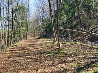 We could see only open dirt and gravel on the trail so we decided to wait until we needed our spikes to put them on. We started out on the trail at 2:15 PM with the temperature at 65 degrees under blue skies with no clouds. On my last hike here, as soon as we entered the trees there was a thick layer of packed snow and ice. Today the trail was wet and muddy in a few spots but there was no ice or snow. I was warm so I made sure I opened all the zippers I could to dump heat. We found a medium-sized trunk across the trail that had been there for some time. We decided to wait until the return trip to remove this one and continued on our way. One look down to the Little Beaverkill showed the stream volume was high but the water was very clear. I wondered about the condition of the falls and whether they would be frozen or not. Sheila was taking her own route and following her nose and getting very close to the edge of the trail where a steep drop led down to the river! A two men came walking toward us with their dog, so I put Sheila on her leash. We said "Hello" as we passed. We came across the first blowdown that was small and could easily be removed with hand tools. We stopped and I took some before pictures. We made a few cuts with the small saw to top out the tree and dragged the branches off the trail. I took some pictures to show the work we had done. As we continued on the trail, we came to two small saplings hanging over the trail. I took my before pictures and the we got to work. It took just two cuts to sever both of the small trunks, We dragged them off the trail and I took some after shots.
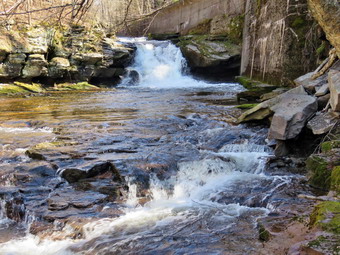 We were soon at the wooden walkways and I decided the views were nice enough to take a few shots. I decided to take a few pictures down to the stream and some of the skies which, unfortunately, had no white clouds. We continued over the wooden walkways and bridges which had no ice remaining. There was some water on the bridge and some mud on the other side. The problem comes from a rock slide that has blocked the culvert under the small bridge causing water, mud and stones to be diverted over the walkway. Unblocking the culvert and covering the walkways with some screening would help. After crossing the bridge, I stopped to shoot a few pictures of the bridge and walkways before continuing on the trail. As we walked along the trail, we had to avoid some wet and muddy areas. We found a nice bench that had a few branches in front of it so we cleared out the area. I took some shots before and afterwards. As we were finishing a father and his children came walking toward us with a stroller. He also had a small dog on a leash. I had Brad leash Sheila and we waited until he passed by us. Not very far after the bench, we found two trunks dipping down into the trail. The problem was they formed a high arch from the bank on the other side of the fence, Brad and I decided the only way to cut the smaller one was to do so from the other side of the fence. I made sure to take some pictures before the work began. We jumped the fence and Brad and I used the ax to cut the tree at its base. As we were finishing the cut, the base of the tree took a wrong turn and hit me in my right shin. I was not knocked down but there was an abrasion from my ankle to my knee and it did smart some. We jumped back over the fence and removed the small trunk we had just cut. We decided to cut the larger trunk as high up as possible. Brad made the cut and which eventually brought down the trunk. We threw the trunk over the bank on the other side and I took some pictures. We continued on the trail to another single but larger trunk that had broken off and was hanging into the trail. I took some shots beforehand then we assessed the job. We decided to cut off the top of the tree with the saw and it went quickly. We turned our attention to the remaining trunk and found we were able to lift and pivot it off the trail. As we finished, it crashed to the ground. Some of the trunk was still lying on the side of the trail so we made a cut ad shoved it over the bank. I took some pictures and then we moved on.
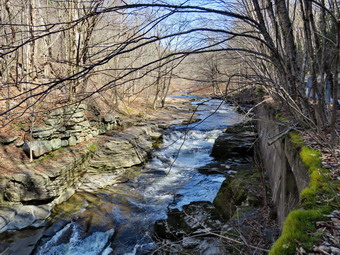 When we arrived at the falls, we found that there was a good flow of water but no ice. We both decided to walk down the path to the streambed at the base of the falls. The last time I was at the falls the path was too icy to descend the whole way. Now the trail was clear of ice and snow and was almost dry. We worked our way down to the streambed where I dropped my pack to take some pictures. I positioned myself and took pictures of the falls and the rapids below the falls. I tried some different angles and zoom levels. When I ws done, I put the camera back in my pack, shouldered the pack, and climbed up the path to the main trail. I put my pack on the bench and once again got out my camera and took some more shots of the falls from above. I also took some pictures of the stream above the falls. I packed up and we turned around and started back toward the car. We set a quick pace and were soon at the first blowdown just before the point where the trail opened. This tree was the largest trunk but it seemed rotten with some cracks. I took my shots and Brad took the ax and easily cut off a section. We moved that section off the side of the trail. Brad spotted another crack and cut off another section which we quickly moved. A man and woman with a dog came walking toward us and I took Sheila by the collar. They passed by us with a greeting. The section that was left was long and solid. We though about cutting it with the KanataBoy which was possible but tiring. I suggested we try to lift the section over the fence. It was a heavy piece of wood but we were able to get it over the fence. I took my final after pictures and we headed for the car. Back at the car I knew I had not missed any ambulance calls as I had my phone with me. There usually aren't other EMTs to cover calls during the day. We were back at the car at 3:20 PM after hiking about 2.0 miles in 2 hours with much of the time being devoted to clearing the trail. There is virtually no elevation gain on the hike.
![]()
![]()
![]()
![]() On Tuesday, April 4th I had intended to get up early and do a longer hike. As often happens, my plans were changed by a rather serious overnight ambulance call. I finally got up at 10:00 AM and did some work for church and for the ambulance corps. I finished what I needed to accomplish by 2:00 PM and contemplated where I could go for a shorter hike. I decided I wanted to go across the street to Round Top to get some exercise with Sheila. The temperature was up to 68 degrees which was as warm as it had been for some time. Sheila was quitely watching my every move but I knew she was excited as we had not been out for a couple of days. I decided to put on a light crew top that I usually wear as a baselayer. I wore my Railriders hiking pants which are expensive but last along time and have features like deep pockets and a generous cut which I really like. The pants have Velcro closures at the ankles. I decided to put on my Keen Durand hiking boots which fit well and are newer than what I have been wearing. I added a new pair of Xstance insoles in an effort to find the best support and cushioning for my feet. These insoles have shock absorbing gel pads, TPU arch support, and memory foam cushioning all wrapped in a breathable fabric. The insoles have been hyped by their manufacturer and they really do seem to deliver. I decided to take my Leki poles with external locks as the internal twist locks sometimes fail. I did don my Mammut hoody as it has enough zippers to dump heat if needed. I put on a light hat and put a light pair of gloves in my pockets. At 2:35 PM we walked out the door to start the hike. I looked around and saw bright blue with puffy white clouds. I grabbed Sheila's leash from the car and we walked up the driveway. We walked across the street and to the parking lot of the Presbyterian Church. We walked behind the church to get to the road up the hill to the trailhead.
On Tuesday, April 4th I had intended to get up early and do a longer hike. As often happens, my plans were changed by a rather serious overnight ambulance call. I finally got up at 10:00 AM and did some work for church and for the ambulance corps. I finished what I needed to accomplish by 2:00 PM and contemplated where I could go for a shorter hike. I decided I wanted to go across the street to Round Top to get some exercise with Sheila. The temperature was up to 68 degrees which was as warm as it had been for some time. Sheila was quitely watching my every move but I knew she was excited as we had not been out for a couple of days. I decided to put on a light crew top that I usually wear as a baselayer. I wore my Railriders hiking pants which are expensive but last along time and have features like deep pockets and a generous cut which I really like. The pants have Velcro closures at the ankles. I decided to put on my Keen Durand hiking boots which fit well and are newer than what I have been wearing. I added a new pair of Xstance insoles in an effort to find the best support and cushioning for my feet. These insoles have shock absorbing gel pads, TPU arch support, and memory foam cushioning all wrapped in a breathable fabric. The insoles have been hyped by their manufacturer and they really do seem to deliver. I decided to take my Leki poles with external locks as the internal twist locks sometimes fail. I did don my Mammut hoody as it has enough zippers to dump heat if needed. I put on a light hat and put a light pair of gloves in my pockets. At 2:35 PM we walked out the door to start the hike. I looked around and saw bright blue with puffy white clouds. I grabbed Sheila's leash from the car and we walked up the driveway. We walked across the street and to the parking lot of the Presbyterian Church. We walked behind the church to get to the road up the hill to the trailhead.
We began the ascent of the steepest hill behind the church. The ground was completely clear with no ice or snow. The hill is short but gets the circulation pumping and is the steepest and longest climb on the "trail." My goal is always to make it all the way up the hill without stopping which proved less challenging than I thought it would be. At the top of the hill we stopped so that I could take a look around. Directly across the valley from Round Top is Beer Mountain next to the Upward Brewery. I reminded myself that I should go and hike there sometime. We turned left and entered the woods to begin our hike. The trail was completely free of snow and ice which made it look like late spring or early summer. A short distance in from the trailhead there was a small tree that had come down in the recent winds. We easily stepped over the small trunk. I new that I would have to come back to remove this blowdown as soon as possible. Just before the first trail junction, we came to the spot where a large tree had fallen across the trail. I had cut one end of the tree with my ax and saw. Brad and I had finished the job. It was almost 2 feet in diameter and we had to cut it several times to move it off the trail. At the first trail junction, I followed Sheila as she continued straight ahead up the hill toward the lookout. When we reached the top of the trail, we walked off the trail to the left to the upper viewpoint. The views down into town and across the valley to the hills beyond were still good as there were no leaves on the trees. After taking in the view, we followed the yellow trail as it headed uphill toward the next trail junction. I was already beginning to get warm so I stopped and opened all the zippers I could. We passed the "sitting rock" and continued on the yellow trail to the first junction with the blue trail. At the junction we turned right and walked the yellow trail along the base of Round Top to the next junction with the blue trail. Some of the trees along the trail were leaning into the trail and I knew they would require some trimming. I noticed that one of the rock overhangs below the ledges still had several tarps forming a shelter. We turned left at the next junction and began climbing the hill. On the way up the hill, we bypassed the white crossover trail and continued on the blue trail across the summit of Round Top. As we began down the other side, we bypassed the white crossover trail and turned left on the switchback in the blue trail. The switchback trail sidehills a little which can make it even harder to negotiate when it is slippery. We continued following the switchback as it took us out into the woods and then turned almost 180 degrees to bring us back to the main blue trail. We turned left and continued downhill on the blue trail. We followed the blue trail to the yellow trail. We turned left and walked on the yellow trail along the base of Round Top to the junction with the blue trail.
This time we turned right and walked down the yellow trail to the woods road. We walked along the woods road toward the first trail junction. Just before the first trail junction, I looked at the remains of the large blowdown I had cut and removed from the trail. Just passed this were the remains of a smaller blowdown I had cut up. This tree had hung over the trail for months but finally came down in the wind. I decided to do another figure 8 but without stopping. We turned around at the first trail junction and started back up the woods road. We turned left when the yellow trail started up toward the first junction with the blue trail. We turned left and walked the yellow trail to the next junction with the blue trail. At the next trail junction we turned right on the blue trail and started up the hill. This trail was a little steeper but it was not very slippery. We turned right on the switchback and followed it out and back to the main blue trail. We almost immediately turned right on the white crossover trail. I wanted to make sure to check out all the trails for blowdowns from the numerous high winds that had come through lately. We continued out to the main blue trail where we turned right. We walked down to the junction with yellow trail where we turned right and again walked along the base of Round Top to the next junction with the blue trail. This time we turned left and continued on the yellow trail passing the "Sitting Rock" to the viewpoint. At the viewpoint we turned left and walked down the steep trail to the first trail junction. This time we continued out to the trailhead. At the trailhead we turned right and walked down the hill to the church parking lot. We crossed the parking lot and Rock Avenue to get to our driveway. When we arrived home, it was 3:50 PM and we had hiked around 2 miles in an hour and 15 minutes. I took Sheila inside and grabbed my Silky Sugowaza saw. I jumped in the car and drove over to the cemetery and up the hill to the trailhead. I parked the car and grabbed my saw. I walked out the trail to the small blowdown across the trail. I made a cut near the top of the blowdown on the right side of the trail. When I was done, I moved to the left side of the trail where the blowdown was larger in diameter. The wood seemed pretty hard as it took me some time to cut through the trunk. To finish the removal, I grabbed the section I cut and flipped it off the trail. I returned to the car and drove back home.
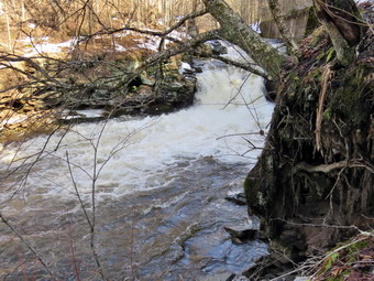
![]()
![]()
![]()
![]()
![]() On Saturday, April 1st I wanted to get out for the first hike of April. When I got up at 7:00 AM the temperature was 55 degrees but it was raining. I decided to wait to see if the rain stopped. In addition, I was one of the only EMTs around to respond on calls. I did some work at home and then went to the ambulance building to do some work there. I returned home at 1:00 PM and decided to get out for the hike as the rain had stopped. I asked Cindy if she would like to hike the Parksville Rail Trail and after some initial reticence she said 'Yes'. We knew the trail might be wet from the rains and would probably still have some snow and ice under the cover of the trees. The hike is about 2.5 miles but I was hoping the falls would be flowing from the recent rains as they are beautiful. We started to get ready at 1:45 PM with the temperature at 65 degrees and a slight warm breeze blowing! Sheila could not contain her excitement as we were getting dressed as if she thought we might not hike again! The skies were blue with some sun and white clouds. I put on my Mammut long-sleeved crew shirt without a baselayer. I wore my Railriders hiking pants which are expensive but last along time and have features like deep pockets and a generous cut which I really like. The pants have Velcro closures at the ankles. I decided to put on my Keen Durand hiking boots which fit well and are newer than what I have been wearing. I added a new pair of Xstance insoles in an effort to find the best support and cushioning for my feet. These insoles have shock absorbing gel pads, TPU arch support, and memory foam cushioning all wrapped in a breathable fabric. The insoles have been hyped by their manufacturer and they really do seem to deliver. I decided to take my Leki poles with external locks as the internal twist locks sometimes fail. I did don my Mammut hoody as it has enough zippers to dump heat if needed. I wore my OR Crocodile gaiters in case there was any show or mud. I did put on a light hat and packed a light pair of gloves. At 2:00 PM I put our gear in the car and Sheila in the back seat and headed out Old Route 17 and drove across the Flats. I took Old Route 17 and Service Road to the point where they meet Fox Mountain Road. There were no vehicles in the parking lot which was completely free of snow and ice.
On Saturday, April 1st I wanted to get out for the first hike of April. When I got up at 7:00 AM the temperature was 55 degrees but it was raining. I decided to wait to see if the rain stopped. In addition, I was one of the only EMTs around to respond on calls. I did some work at home and then went to the ambulance building to do some work there. I returned home at 1:00 PM and decided to get out for the hike as the rain had stopped. I asked Cindy if she would like to hike the Parksville Rail Trail and after some initial reticence she said 'Yes'. We knew the trail might be wet from the rains and would probably still have some snow and ice under the cover of the trees. The hike is about 2.5 miles but I was hoping the falls would be flowing from the recent rains as they are beautiful. We started to get ready at 1:45 PM with the temperature at 65 degrees and a slight warm breeze blowing! Sheila could not contain her excitement as we were getting dressed as if she thought we might not hike again! The skies were blue with some sun and white clouds. I put on my Mammut long-sleeved crew shirt without a baselayer. I wore my Railriders hiking pants which are expensive but last along time and have features like deep pockets and a generous cut which I really like. The pants have Velcro closures at the ankles. I decided to put on my Keen Durand hiking boots which fit well and are newer than what I have been wearing. I added a new pair of Xstance insoles in an effort to find the best support and cushioning for my feet. These insoles have shock absorbing gel pads, TPU arch support, and memory foam cushioning all wrapped in a breathable fabric. The insoles have been hyped by their manufacturer and they really do seem to deliver. I decided to take my Leki poles with external locks as the internal twist locks sometimes fail. I did don my Mammut hoody as it has enough zippers to dump heat if needed. I wore my OR Crocodile gaiters in case there was any show or mud. I did put on a light hat and packed a light pair of gloves. At 2:00 PM I put our gear in the car and Sheila in the back seat and headed out Old Route 17 and drove across the Flats. I took Old Route 17 and Service Road to the point where they meet Fox Mountain Road. There were no vehicles in the parking lot which was completely free of snow and ice.
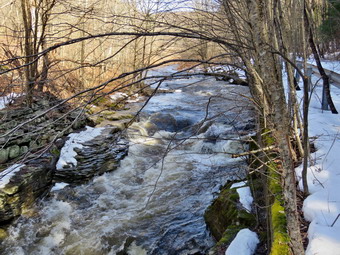 We decided to wait until we needed our spikes to put them on as the trail leading out of parking lot was clear. We started out on the trail at 2:15 PM with the temperature at 68 degrees under blue skies with white clouds. The open trail just before the woods was clear of ice and snow. As soon as we entered the trees there was a thick layer of packed snow and ice. Cindy and I were able to walk along the snow on the side of the trail without any problems. I was warm so I made sure I opened all the zippers I could to dump heat. We found a medium-sized trunk across the trail that had been there for some time. The tree looked like I could cut it with a hand saw and ax to get it off the trail. One look down to the Little Beaverkill showed the stream volume was high and the water was slightly muddy. I wondered about the condition of the falls and whether they would be frozen or not. Sheila was taking her own route and following her nose and getting very close to the edge of the trail where a steep drop led down to the river! We came across another blowdown that was small and could easily be removed with hand tools. We were soon at the wooden walkways and I decided the views were nice enough to take a few shots. I decided to take a few pictures down to the stream and some of the skies. We continued over the wooden walkways and bridges taking our time as they were covered in ice with water on top! The ice problem comes from a rock slide that has blocked the culvert under the small bridge causing water, mud and stones to be diverted over the walkway. Unblocking the culvert and covering the walkways with some screening would help. This time it was a lot of water that had frozen on the bridge, the walkways, and the trail. After crossing the bridge, I stopped to shoot a few pictures of the bridge and walkways before contending on the trail. As we walked along the trail and found a few blowdowns that should be cleared. At this point there was quite a bit of water on the trail. Some of the water was on top of the ice while some of it was under the ice. Both situations made walking along the trail challenging. As we approached the falls, we could hear the sound of the falls roaring.
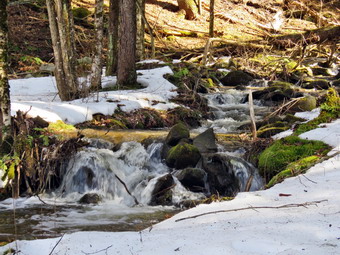 When we arrived at the falls, we found that there was an incredible flow of water but no ice. We both decided to sit on the bench and put on our spikes. After looking at the path down to the stream, I almost decided to forgo the attempt. The path looked frozen solid and I knew Sheila would follow me. I changed my mind and started to work my way down the path by breaking the frozen snow ahead of me with my spikes while anchoring myself with the poles. I worked my way down to the last few feet and saw the ice that covered the rest of the way down to the stream. I decided I had gone far enough and set down my pack to get out my camera. I positioned myself and took pictures of the falls and the rapids below. When I ws done, I put the camera back in my pack, shouldered the pack, and climbed up the path to the main trail.I once again got out my camera and took some more shots of the falls from above. I also took some pictures of the stream above the falls. I packed up and we started toward Parksville. We decided to continue the hike on the trail but walked by the bench where a path leads down to the stream. This area was not that interesting and I just wanted to walk. We found more and more water on the trail extending across the entire width of the trail. We decided we would turn around as the rest of the trail is short and not that interesting. Wearing our spikes allowed us to set a quick pace as we started back toward the car. At one point I looked off to the left of the trail and saw a small stream with some interesting rapids and small falls. I had not noticed this stream before and decided to investigate. Cindy decided she would stay on the main trail. I found a way down the steep bank and a narrow spot in the stream to cross. I thought it was interesting that water was flowing in two different directions in the stream. I noticed that there was a culvert leading under the rail trail and stopped to take some pictures. There were actually two culverts dating to the time when the rail line ran through the area. Sheila was already ahead of me picking a way toward the rapids to avoid the network of streams that ran under the frozen snow. We finally worked our way up to a spot where I could get an angle to take my pictures. I would have liked to cross the stream for a better angle but it was a little too deep and a little too wide. I took various shots and then repositioned for some more. When I was done, I packed up and followed my tracks back to the path up the bank to the main trail. I hopped the stream and scrambled up the bank to the main trail. Cindy and I made quick work of the rest of the trail. We stopped as we came out of the trees so that I could remove my spikes. Cindy decided to keep hers on. Back at the car I knew I had not missed any ambulance calls as I had my phone with me. There usually aren't other EMTs to cover calls during the day. We were back at the car at 3:30 PM after hiking about 2.4 miles in 1 hour and 45 minutes. There is virtually no elevation gain on the hike.
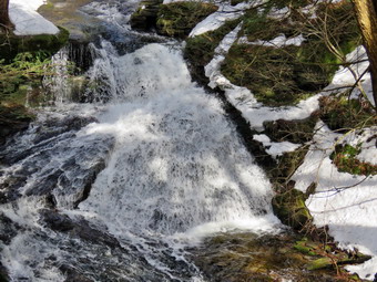
![]()
![]()
![]()
![]()
![]() On Friday, March 24th I wanted to get out for a longer hike than I had been doing lately. I knew I might be the only EMT around but hoped I could get the hike in without missing a call. I had been avoiding Trout Pond for most of the winter as the parking situation is poor. Russell Brook Road is not maintained in the winter so the only parking is along the side of Morton Hill Road which only works when there are no snowplows working. When I got up at 8:00 AM it was already 30 degrees. I knew Sheila would be happy to go and that Cindy was not interested. Sheila and I were on our own. I started to get ready at 10:45 AM and Sheila was especially excited as I began to dress so she watched every move I made. I put on my Mammut long-sleeved crew top with a long-sleeved baselayer since the temperature was cool. I wore a pair of Bauer First Ascent pants which are insulated against the cold and are slightly water repellant. I don't like the fit of these pants and have been looking for a replacement. I wore my Solomon B-52 winter hiking boots as I did not know how much snow and ice to expect. These boots are old and beginning to show some wear but I replaced the insoles with a pair of Protalus insoles to provide arch support. I grabbed my Leki external lock poles which I have been using since the spring since twist locks have proved unreliable. I also donned my Mammut hoody which was enough zippers to dump heat when needed. I put on a light hat and wore a light pair of gloves. I also put on my OR Crocodile gaiters which some almost to my knee to deal with the snow and to keep my lower legs warm. I decided not to take snowshoes as I knew the recent increasing temperatures and rain would have reduced the amount of snow. I made sure I had a heavier pair of gloves in my pack and that I had my Kahtoola Microspikes. I put my gear in the back of the car and Sheila in the backseat and headed for Roscoe on the Quickway at 10:10 AM. I got off at exit 94, turned left and drove out the Rockland Flats on Route 206. Just after the Roscoe Nursing Home I turned left on Morton Hill Road and followed it for 3 miles to the intersection with Russell Brook Road. I took a look at Russell Brook Road Stewart State Forest Swamp 8 found it completely covered in ice and a significant amount of snow! I turned around and parked on the shoulder of the road to avoid parking in the private lot. The temperature was 37 degrees with some blue skies, clouds and a touch of sun. There were no other cars parked.
On Friday, March 24th I wanted to get out for a longer hike than I had been doing lately. I knew I might be the only EMT around but hoped I could get the hike in without missing a call. I had been avoiding Trout Pond for most of the winter as the parking situation is poor. Russell Brook Road is not maintained in the winter so the only parking is along the side of Morton Hill Road which only works when there are no snowplows working. When I got up at 8:00 AM it was already 30 degrees. I knew Sheila would be happy to go and that Cindy was not interested. Sheila and I were on our own. I started to get ready at 10:45 AM and Sheila was especially excited as I began to dress so she watched every move I made. I put on my Mammut long-sleeved crew top with a long-sleeved baselayer since the temperature was cool. I wore a pair of Bauer First Ascent pants which are insulated against the cold and are slightly water repellant. I don't like the fit of these pants and have been looking for a replacement. I wore my Solomon B-52 winter hiking boots as I did not know how much snow and ice to expect. These boots are old and beginning to show some wear but I replaced the insoles with a pair of Protalus insoles to provide arch support. I grabbed my Leki external lock poles which I have been using since the spring since twist locks have proved unreliable. I also donned my Mammut hoody which was enough zippers to dump heat when needed. I put on a light hat and wore a light pair of gloves. I also put on my OR Crocodile gaiters which some almost to my knee to deal with the snow and to keep my lower legs warm. I decided not to take snowshoes as I knew the recent increasing temperatures and rain would have reduced the amount of snow. I made sure I had a heavier pair of gloves in my pack and that I had my Kahtoola Microspikes. I put my gear in the back of the car and Sheila in the backseat and headed for Roscoe on the Quickway at 10:10 AM. I got off at exit 94, turned left and drove out the Rockland Flats on Route 206. Just after the Roscoe Nursing Home I turned left on Morton Hill Road and followed it for 3 miles to the intersection with Russell Brook Road. I took a look at Russell Brook Road Stewart State Forest Swamp 8 found it completely covered in ice and a significant amount of snow! I turned around and parked on the shoulder of the road to avoid parking in the private lot. The temperature was 37 degrees with some blue skies, clouds and a touch of sun. There were no other cars parked.
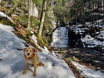 I set my Garmin GPS unit and we started down Russell Brook Road as I planned to make the upper falls our first stop. Russell Brook Road was worse than it looked. It was a frozen mess of snow and ice and deep ruts where someone had thought they could drive. I did see some snowmobile tracks which I knew would make walking easier. Once we were passed the deep ruts the snow was for a long time and frozen solid. I was slipping and sliding all over the place so we stopped next to a big tree where I put on my spikes. We continued down the road and I could not see any other tracks from hikers. With the spikes, the frozen snow allowed me to make good time hiking downhill. Sheila always makes good time. We continued to walk quickly downhill to the path down to the viewpoint above the falls. Sheila headed down the path and I could see her slip and slip on the frozen snow and ice. I considered abandoning the plans to take pictures here but the falls were just too nice to miss. I turned down the path to the upper falls and got to a place where I had a good angle to take pictures. I did not feel safe going ay further to the spot where I usually take shots. I called Sheila away from the edge of the gorge and put down my pack and got out the camera. There was more water going over the falls than I thought there might be as I took several shots with differing settings. Once I finished the photography, I packed up, and we walked back up to the road with some difficulty. We walked down to the parking area walking around a large tree that was across the road. The parking area was empty but there were snowmobile tracks across it which headed down toward Russell Brook. There was another large tree down in the lot near the kiosk. We walked down the woods road to cross Russell Brook. We crossed the bridge and found that the Japanese knotweed was completely dead. It was so dead it looked like it could never come back but it does every year. I took a few shots. We turned right on the informal path to the falls and walked the path until we came to the path down the bank. Since this area was exposed to the sun, there was little or no snow. The path down to the streambed was covered with a combination of hard packed snow and ice. I started down the path but was having trouble getting any grip. At the point where I was about to try to get down to the streambed, I noticed it was solid ice. I decided to take pictures from where I was standing which offered a view almost as good as from lower down. The falls were flowing with a good volume as high as I had seen it in some time. I took some pictures of the falls and then some of the stream. I took a few more pictures of the falls and a few of Sheila with the falls in the background. When I was done I stowed the camera and we carefully walked back up the stream bank and out to the main trail.
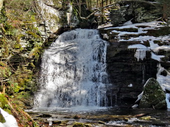 We turn right to walk to the trail register and found that the trail was almost bare but with some water and mud. We stayed to the right at the trail junction just after the register and continued straight ahead to walk up to Trout Pond. There were a few places where the snow was thin and where small streams crossed the trail or ran down it. We continued our walk up the trail and I began to feel warm. When we arrived at the pond, we turned left and walked out to the "beach" at the outlet end of the pond. The snow here was deeper where it had drift off the pond. The level of the pond was high enough to allow water to pass over the outlet even though the pond was still covered with ice. There was open water near the shore and a small beaver dam at the outlet helped raise the level. The skies were blue with some white clouds. I got out my camera and took pictures of the pond, the outlet and some along the shoreline. Sheila was smart enough to aroid going near the pond. I took some pictures of the whole scene and then zoomed in on different parts. After getting a drink and a snack, I packed up and we headed back to the main trail through some deep snow. I was beginning to feel tired and wondered whether I wanted to complete the whole loop. We turned left and continued on the main trail on the east side of Trout Pond walking toward the inlet end and the lean-tos. The trail was snow covered and well-packs in most places by snowmobiles with a only few open spots. We crossed the small stream just before the lower lean-to. No one was camping at the large campsite on the right side of the trail before the lean-tos or at the lean-tos themselves. As we crossed the bridge at the inlet end of the pond, I noticed that the inlet stream was high. I decided to stop to take pictures of the pond from the bridge as I was not on a schedule. I was surprised that the snowmobiles had continued on the trail over the shoulder of Cherry Ridge. This helped convince me to continue the loop. We continued on the trail by turning right and starting up a hill which is the shoulder of Cherry Ridge. I had been worried that I would have to break trail here but the snowmobile tracks continued all the way up and over the shoulder of Cherry Ridge. We easily walked up the hill and I noticed it was easier walking on the smooth packed trail than over the rocks and roots that are usually there. In places the snow was soft and I was sinking in some places which was tiring. I hoped the snow would continue to support me as my inner thighs were beginning to burn. As we continued to hike, we ran into a few blowdowns from the recent winds but these were relatively small. Soon we were at the highest point on Cherry Ridge and starting down the other side.
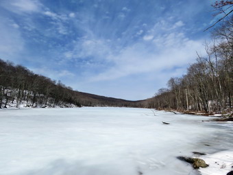 I anticipated that the trail would have some open areas with water and I was right. There were places that had some standing water and some flowing like a stream. Of course, in these areas I tried to walk on the side of the trail. We passed by several spots where I had cleared blowdowns previously. We continued on the trail to the point where we were ascending to the area where there is a forest of small birch trees. Sooner than I thought we were at the woods road and snowmobile trail that runs by Mud Pond. We turned left and started the short walk uphill. This part of the trail had a covering of snow alternating with slush, water and mud. At the top of the hill, we began the long descent back to the trail junction where we had started. The descent lasts for .7 miles and drops 385 feet to a bridge that crosses the outlet stream from Trout Pond. From the top of the hill to the bottom there was almost no snow on the trail and I even considered taking off my spikes. There was plenty of water on the trail and some mud. In places, streams crossed the trail including a rather large one near the bottom. On the other side of the stream, there was a very large blowdown blocking the trail. Sheila and I bushwhacked around the blowdown and rejoined the trail on the other side. The campsite at the bottom of the hill on the left side of the trail was also empty but by this time there was more snow on the trail. We continued on the trail crossing the bridge over the stream and walking back out to the trail register. We turned right and headed back toward the lower parking area on the main trail. It was obvious there was less now on the trail then when we started the hike. We walked up the short path to the lower parking area and continued up the road to the car. The hike up the hill to the car proved to be challenging for me as I am not in shape. As we neared Morton Hill Road it was clear that one or more vehicles had tried to make it down the road. It seemed they had some problems that required some tree branches to give them traction. As we came to Morton Hill Road, I was surprised to see that none of those cars had stayed around. We arrived back at the car at 3:25 PM after hiking 5.7 miles in 3 hours and 55 minutes with a 1130 foot total ascent. Our moving speed was 1.6 mph which is slow but not bad for the shape I am in and the trail conditions. The temperature on the car thermometer was 47 degrees.